Atlas
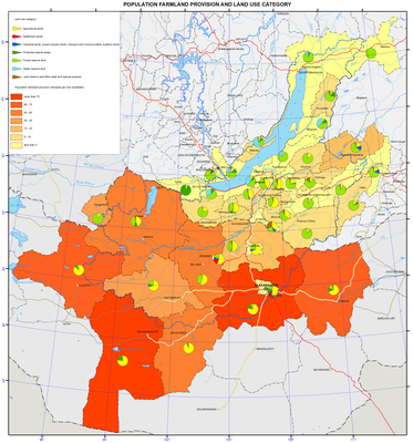
Population farmland provision and land use category map
Land resources and their use
Land resources are the main spatial basis, a store of various types of mineral resources for many branches of industry, as well as a basic means of production for agriculture and forestry. For the latter branches land resources and soil fertility are important means of growing crops and forest stands. For other types of land use (residential, transport, etc.) the role of land resources is reduced mainly to the role of the operational basis for spatial location of specific objects inherent to these types of land use.
Under the working legislation and established practice state land registration in the Russian Federation is carried out on land categories and agricultural lands, forms of ownership and types of land rights, as well as their use for agricultural production and other needs. Land registration in Mongolia is carried out similarly (with minor changes).
On the basic map the land fund structure on agricultural lands is presented as a quality background. The latter ones are defined as land, systematically used or usable for specific economic purposes and different in their natural and historical features. Land carries material properties typical of land use as an economic phenomenon.
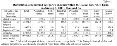
The second map and the Table represent the layout of the land fund on land categories and the index of availability of agricultural land. Land categories are land plots distinguished according to their intended use (agricultural land, settlements, industry, energy, transport, communication, defense and security, etc., forest, water resources, reserves, etc.). Mongolia is characterized by the absence of the concept of "land reserve". However, a large share of the land fund structure there belongs to public land for special purposes, which consists not only of lands of defense and security and protected areas, but lands, used in ways uncharacteristic of Russia. Therefore, in the map legend the category "lands of state and special purpose" applies only to Mongolia, excluding the land of specially protected natural areas and defense and security lands. The latter ones are included in the respective land categories.
The availability index of farmland is the ratio of agricultural land area (in hectares) belonging to the agricultural land to the number of residents living in the municipality. Farmland is an essential part of land, which is a potential resource for the formation of local food base. The average area of agricultural land per capita (within Russian territory, except Tere-Khol district of the Republic of Tyva) amounts to 3.7 hectares; it ranges from 0.06 ha within Sludyansky district of Irkutsk oblast to 22.9 ha in the Eravninsky district of the Republic of Buryatia. Within the Mongolian territory the indicators of the agricultural land per aimak inhabitant, is on the average significantly higher than in the Russian part of the basin as it amounts to about 45 hectares. Minimum rates are found in the Ulaanbaatar, Darkhan, and Orkhon aimaks, which is connected, first of all, with the high population numbers in these aimaks and relatively smaller areas of agricultural land compared to other aimaks.
In 1990 – 2010 the reduction of agricultural area for most municipalities is registered in the Russian part of the basin, which is directly linked to their withdrawal from agricultural use. The main reason of the reduction of such agricultural areas was shutdown of many agricultural enterprises, organizations, and farms and transfer of the withdrawn lands, for the most part, to the land redistribution fund. Another reason is the expiration of the land leasehold (or temporary use) and non renewal of its agricultural productivity. The agricultural land reduction is caused by negative processes became widespread due to the sharp reduction of valuable land protection measures from water and wind erosion, flooding, bogging, waterlogging and other processes. It should be noted that the actual outflow of productive land is much higher. Previously transferred farmland reserves are overgrown with shrubs and low forests and lose their agricultural value.
In Mongolia problems of agricultural lands reduction are currently not registered because of their significant amount due to natural factors and historical specific features of agriculture.
Document Actions
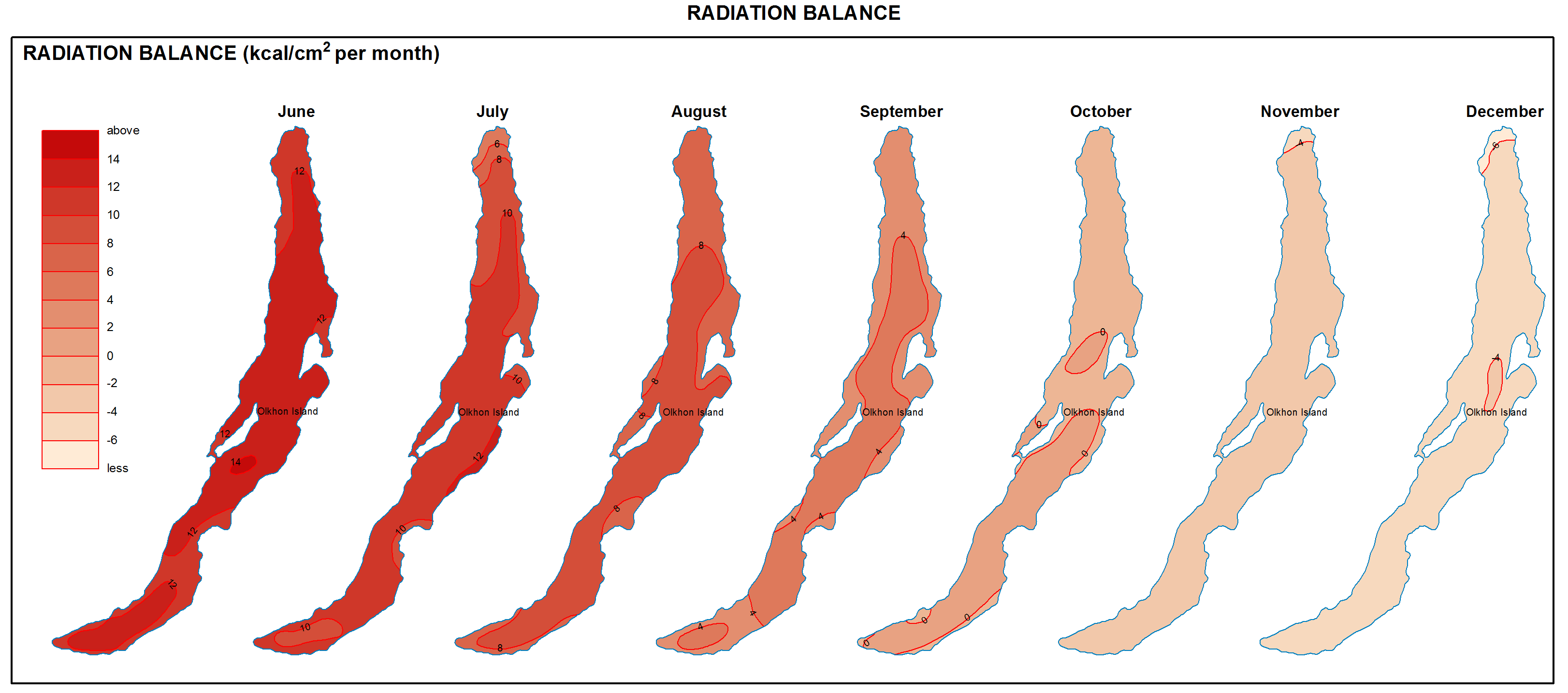
Radiation balance map

Radiation and thermal balance of water surface
Absorbed solar radiation is the main thermal source of the lake water column. It depends on incident solar radiation and the ratio of reflected radiation (albedo). Thus, it has a well-defined seasonal trend. Radiation balance of the Lake Baikal water surface is a sum of absorbed solar radiation and effective radiation of water surface. This balance is positive from April to September and negative from October to March. In general, radiation balance of the lake is positive throughout the year, changing from 1,900 MJ/m2 in the Selenga river area to 700-800 MJ/m2 in the northern part of the lake. Spatial distribution of radiation balance of the lake surface depends on cloud regime during warm period. Radiation balance varies insignificantly because of inconsiderable changes of the cloud cover. In cold period, the distribution of radiation balance is influenced not only by the cloud cover but also by the difference in the albedo of water and snow. Therefore, the radiation balance in Northern Baikal is much lower than that in Central and Southern Baikal. Radiation balance of the water surface is a determining element in the thermal regime of the lake. Because of high water heat capacity, constant time lag is recorded in the seasonal trend of temperature parameters in comparison with radiation characteristics. Therefore, maximal accumulated radiation and radiation balance are recorded at Lake Baikal in June and the highest air and water temperatures in August.
Document Actions
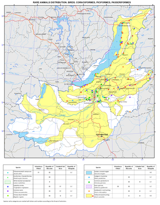
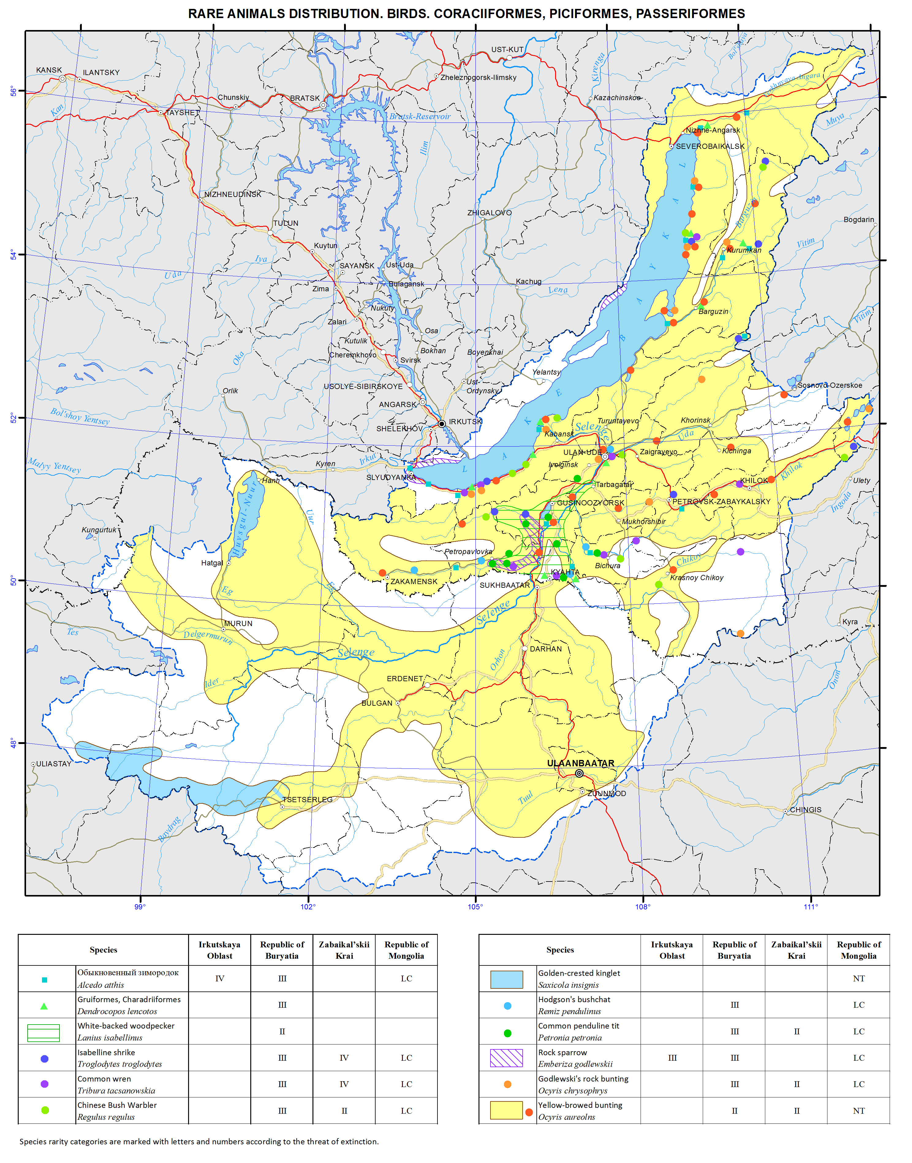
Rare animals distribution. Birds. Coraciiformes, piciformes, passeriformes map
Rare species of fauna
The animal kingdom of the Baikal basin is rich and diverse. The basin’s fauna is unique due to a peculiar geographic location of this region, which explains the extreme diversity of the species composition including many genetically and environmentally heterogeneous elements. In this region, the contact and overlapping of many systemically and ecologically close species and subspecies take place. A large number of forms is represented by the periphery and even isolated populations preserved in the local refugiums since the last glacial period. As a rule, all these species are relatively rare and small in number, and their habitats cover a small territory. Therefore, all of them have been listed in the Red Books and require special protection.
A series of maps of this section provides an insight about the spread of rare species of animals grouped according to their systematic features into separate categories: fish, amphibians and reptiles, birds and mammals. The maps show the main habitats of rare species based on the literature and museum collection research, as well as personal observations of the authors. The maps also show home ranges of certain species.
More than 60 species of fish live in rivers and water bodies of the Baikal basin with half of them being endemic or relict species. The indigenous ichthyofauna of the Baikal basin’s rivers and lakes formed on the basis of the species of the boreal piedmont, boreal lowland, and arctic freshwater complexes; only the Siberian sturgeon and tench are remnants of the ancient late Tertiary faunal complex. Species representing other faunal complexes got into these water bodies as a result of introduction or invasion. In Lake Baikal, the level of endemism reaches 55% of all fish species, which is indicative of the autochthonous nature of the formation of the nucleus of the lake’s ichthyofauna. Only 10 species of fish are found in Lake Khovsgol, with half of them being valuable commercial fishery species. More than a half of the fish species listed in the regional Red Books of the Russian Federation and Mongolia are valuable commercial fishery species. However, their number has been significantly reduced due to the intensive human economic activities over the past 100 years. Overfishing, construction of hydro-technical facilities, and water body pollution negatively impacted their population and resulted in the partial loss of habitat. Today, 15 fish species in the Baikal basin require protection and artificial breeding in order to restore their number.
The Baikal basin is characterized by a low diversity of species of the herpetofauna (altogether about 20 species) due to harsh weather conditions in the region and the history of faunal formation. On the other hand, the basin is a place of contact of the habitats of the Western and Eastern Palearctic species, while representatives of the Central Asian and Daur-Mongolian fauna are wedging in from the south. Half of the species inhabiting this area are located on the periphery of their habitats. Anthropogenic transformation of habitats, drainage and contamination of water bodies, frequent fires, high recreational stress, and extermination by humans decrease the number and fragment the habitats of many herpetofauna species. At present, four amphibian species and six reptile species need protection.
Peculiarity of natural landscapes, climatic and geomorphological conditions, and the historical process of the formation of the ornithofauna resulted in its species diversity. The nucleus of the structure of the population of the basin’s ornithofauna is composed by representatives of the Siberian, Mongolian, Chinese, European and Arctic types of fauna. Transpalearctic species also make up a sizable proportion. Species of the Tibetan and Mediterranean types of fauna make up only a small share of species. Modern ornithofauna of the Baikal basin includes over 400 species; about 100 of them need protection. Human economic activity ambiguously impacts the structure of the ornithofauna. Transformation of the environment as a result of logging, fires, overgrazing, or steppe ploughing may decrease the number of some species, but, on the other hand, it may expand the habitats or the number of other species. Stenobiontic species are affected by economic activity the most. Transformation of habitats, changes in the hydrological regime of certain rivers and Lake Baikal, poaching, logging, fires, and technogenic emissions, all against the backdrop of fluctuations of environmental and climatic conditions, result in the decrease of diversity and number of the majority of bird species.
The fauna of mammals is quite specific and diverse including over 90 species. Many of these species are located on the periphery of their ranges. The modern mammal fauna of the basin is represented by almost 20 faunulas, the largest of which in terms of the number of species are the following: the Holarctic arctic boreal, taiga Palearctic, western Palearctic taiga, Holarctic tundra and golets, steppe southern Palearctic, and Central Asian elements, as well as the East Asian and southern Palearctic flying mammals. A small number of species of the basin either acclimatized or followed the humans. Compared to other animals, mammals are more affected by the direct anthropogenic impact. Thus, the majority of mammals listed as rare species in the near past were or still are considered as game animals, but their population was sharply reduced due to unregulated hunting and poaching. It is not uncommon that the activities aimed at preventing zoonotic infectious diseases led to a sharp decrease of infection hosts – rodents. Logging, steppe ploughing, overgrazing, frequent fires, and the fragmentation of natural territories devastatingly impacted the majority of mammalian species inhabiting the Baikal basin. Therefore, over 30 species now require special protection and reproduction.
The Red Books of the Russian Federation (2008) and Mongolia (1997), as well as regional Red Books of Irkutsk oblast (2010), Republic of Buryatia (2013), and Zabaikalsky krai (2012) were created to protect rare and endangered species. The categories set forth in the Red Book of the Russian Federation (2008) were used as a basis for the development of the regional categories of rarity and the degree of endangerment. Minor amendments were introduced to reflect regional characteristics of the biota. In particular, two regional categories (VI) and (VII) were included due to geographic features of the Republic of Buryatia (location near state border, existence of major biogeographic boundaries and important migration routes, and so on). The categories of the IUCN were used for rare species of vertebrate animals in Mongolia.
References
The Red Book of Zabaikalsky krai: Animals. (2012). Novosibirsk: Novosibirsk Publishing. p 344.
The Red Book of Irkutsk oblast (2010). Irkutsk: Wind of Travel Publishing. p 480.
The Red Book of the Republic of Buryatia: Rare and endangered species of animals, plants, and mushrooms. (2013). Ulan-Ude: BSC SB RAS Publishing. p 688.
The Red Book of the Russian Federation: Animals. (2001). Moscow: Astrel. p 862.
Mongolian Red List of birds. (2006). Ulaanbaatar: ADMON Printing. p 1036.
Mongolian Red List of fish. (2006). Ulaanbaatar: ADMON Printing. p 68.
Mongolian Red List of mammals. (2006). Ulaanbaatar: ADMON Printing. p 96.
Mongolian Red List of reptiles and amphibians. (2006). Ulaanbaatar: ADMON Printing. p 68.
