Atlas
Recreation on Lake Baikal shores map
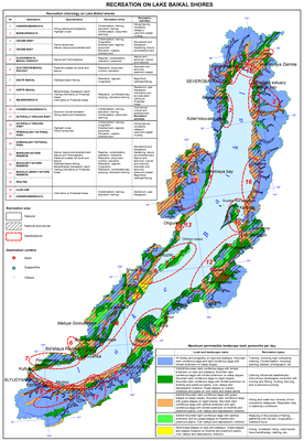
Recreation on Lake Baikal
Recreation as an essential type of human activity is mapped as an integral phenomenon. The degree of territorial development of recreational activities is reflected through the use of zoning (natural and natural-social recreation zones). The zones' borders correspond to the isohypse of 1500 m. The contours are defined by a natural and landscape differentiation. Five levels of maximum permissible density (people/ha/day) have been identified.
The main point in the explanatory note is the district and settlement zoning of recreation territories (the main and supplemental recreation centers) with due consideration to the typology of destinations and their specialization by forms and types of recreational activities.
Assessment of the coastal landscapes for recreational activities.
Natural landscapes untouched by human activity directly and comprehensively satisfy the requirements of the physiologically needed recreation (unconscious-reflectory), such as contemplation, solace, relaxation, and so on. These landscapes (groups of landscapes) must be protected. The most accessible part of the Baikal coast demonstrates a certain degree of environmental transformation. Social and specific (purposeful and deliberate) forms of recreation dominate recreation activities on these territories. The accumulation of the problems connected to the anthropogenic impact leads to the digression of landscapes and even to the loss of landscape diversity and total uselessness of the territory in terms of meeting the needs of recreation.
The map shows the types and subtypes of natural landscapes within the Central Ecological Zone of Lake Baikal. It also shows the zones of natural resources management, where integrated targets of the landscape and territorial planning should be achieved (preservation, improvement, development), and the territories that should be protected and recultivated
Document Actions
Recreational resources of climate map
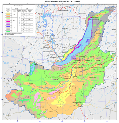
Recreational climate resources
A complex of several climatic factors, such as high sunshine duration (from 2800 hours per annum in the south of the basin to 1500 hours per annum in the north), wide range of heat supply (the sum of mean daily temperatures above 10° C varies from 2400 in the south of the basin to 244 in the highlands), sustained low temperatures in the hollow land forms, and predominantly low wind velocities contribute to the formation of local climates with highly varied suitability for seasonal recreation. Background climatic characteristics of diverse territories, such as hollow, valley, low-, mid-, and high-altitude vary considerably. Their main features in this case are characterized by a number of differently directed indices, whose combined impact on humans can have a similar effect. The same air temperature has a dissimilar thermal effect on a human body in the case of different wind velocities and different air humidity.
Normal-equivalent-effective temperature (NEET) method is often used to take into consideration their combined influence upon the thermal state of man. The levels of comfortable perception of heat according to the NEET scale vary within a broad range depending on the degree of man’s adaptation to environmental conditions. The use of the duration of NEET values above 8 °C for the background assessment of contrasting territories demonstrated its validity [Bashalkhanova et al., 2012].
Reduced temperature (Qred) indicates heat losses from the open surface of human body in the wintertime under a combined effect of air temperature and wind velocity [Khairulin and Karpenko, 2005]. With Qred below −32 °C, the risk of frostbite increases, so recreation in the open air is limited.
In the total form the complex of the most important characteristics of climatic resources favorable for recreation is represented by the duration of periods with NEET above 8 °C and those limiting it – by Qred below −32 °C.
Spatial distribution of indicators under study is dependent on a complex interaction of the main climate forcing factors, such as radiative and circulatory ones as well as the underlying surface properties, which provide a variety of mesoclimatic conditions, manifestation of latitudinal and altitudinal zonality elements and local patterns for recreational activity
In summer the variety of landscape conditions exerts considerable influence on climatic regimes formation alongside with the latitudinal factor. The plain-valley mesoclimates combining the steppe, steppificated, and subtaiga piedmont pine landscapes of slopes, plains and river valleys are characterized by the broadest possibilities for recreation and treatment of the population [Landscapes…, 1977; National…1990]. The duration of days with the NEET above 8 °C is highest. Recreational resources of the climate of uplands and mountainous territories are substantially lower; they are characterized by a shorter duration of the favorable period. The duration decreases dramatically depending on the latitudinal and altitudinal location of natural complexes. For instance, for the dark coniferous landscapes of uplands, dark coniferous and larch piedmont and intermontane depressions as well as bogged larch depressions on the plains its duration is from 40 to 70 days. In the mountain-taiga landscapes of flat (sometimes slope) surfaces as well as in dark coniferous landscapes of high slopes and plateaus, this period is less than 40 days. In high mountains with goletz, subgoletz and, partly, mountain-taiga larch forests, the mean monthly NEETs do not reach 8 °C.
The low recreational potential of the climate in winter is conditioned by circulation and astronomical factors. In the subtypes of climates weakly differing in summer (plain-valley, narrow valley and highlands) elements of latitudinal zonality are clearly traced. The period of possible limitation of recreation in the open air in the northern and southern parts of the basin can differ nearly twofold. Meanwhile the stagnant phenomena in orographically isolated intermontane depressions and closed river valleys are accompanied by the longest period of Qred below −32 °C, which reveals more favorable conditions on their slopes. The severity of winters for open surfaces of slopes and summits obeys the wind regime.
Quite special conditions occur on the shores of Lake Baikal. The warming (in winter) and cooling (in summer) influence of the lake’s water masses showed a shift toward a decrease in climatic-physiological comfort of landscapes when compared with their counterparts outside the influence zone. This is largely due to the large horizontal temperature gradients between land and lake, which are often the cause of strong winds, the exceptional variety, unpredictability and velocity of which are well known. For that reason, on certain parts of the shore, especially in the west, in the mountain-taiga pine and larch landscapes the number of days with the NEET above 8 °C is lowest (less than 40 days). Meanwhile, in the wind-proof parts of the shore (Peschanaya Bay, the Kuchelga river valley, etc.) the conditions for recreation are optimal. In winter the dependence of the climatic-recreational potential on the location grows even further. In some shore areas relatively favorable in the summer season, the length of the period of reduced temperature below −32 °C differs substantially.
On the whole, the recreation resources of the climate across the territory are relatively varied. Given the availability of mud-bath resources in the depressions and broad river valleys with a shorter length of the limiting period, there is a possibility of launching the sanatorium-and-spa treatment. Of considerable interest are the middle mountains of Khangai and the interfluves of the Selenga and Orkhon rivers. The climatic resources of other territories are more suitable for extensive development and promotion of tourism and stationary recreation. Because of the low heat availability and abrupt fluctuations in the temperature-wind regime, the shores of Lake Baikal and Lake Hovsgol are favorable for recreation of healthy people only. Obviously, depending on the characteristics of heat and moisture exchange and on the regime of the local circulation, the period for different kinds of recreation is variable. Thus, the slopes of the Khamar-Daban on the southern shores of Lake Baikal are most favorable for the winter kinds of recreation due to the abundance of snow, and the appropriate combination of temperature and wind regimes. The shores of Middle Baikal characterized by a long duration of sunshine are more favorable for summer recreation.
The experience of the cartographic analysis and multiscale assessment of recreational resources of the climate showed that in a number of cases climate resources essential for the recreation of people and conditioned by microclimatic differences may considerably exceed their latitudinal background parameters. Thus, a comprehensive expert examination of the recreational resources of the climate is important when a certain area is selected for implementation of investment projects.
References
Bashalkhanova, L.B., Veselova, V.N. and Korytny, L.M. (2012). Resource Dimension of Social Conditions for the Life of the Population of East Siberia, Novosibirsk: Geo, 221 p. [in Russian].
Landscapes of the South of East Siberia (1:1 500 000 Map). (1977). V.S. Mikheev and V.A. Ryashin, Moscow: GUGK, 4 sh. [in Russian].
Mongol ulsyn undesnii atlas. (2009). Ulaan-Baatar: SHUA. Gazarzuin khurzelen. - 248 p. [in Mongolian].
Document Actions
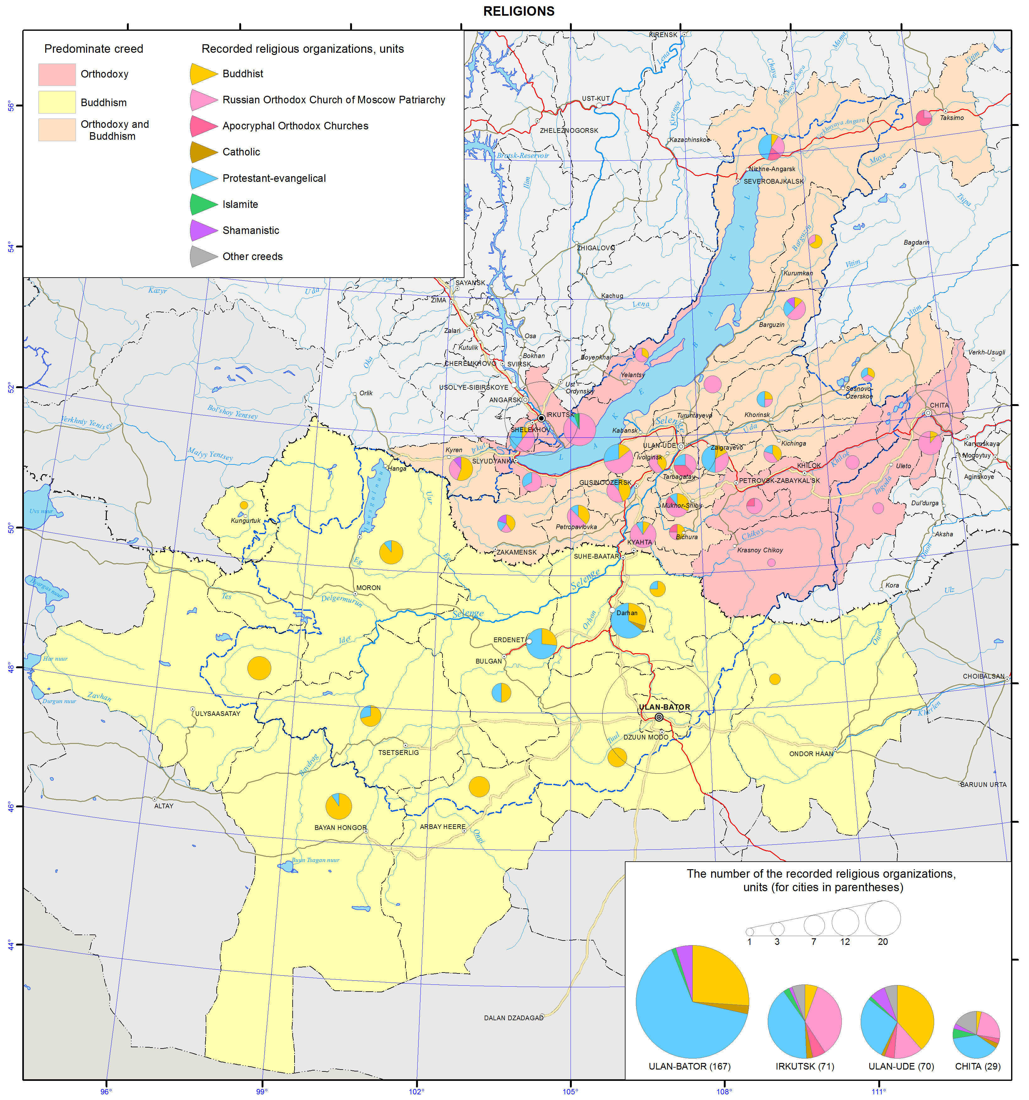
Religions map
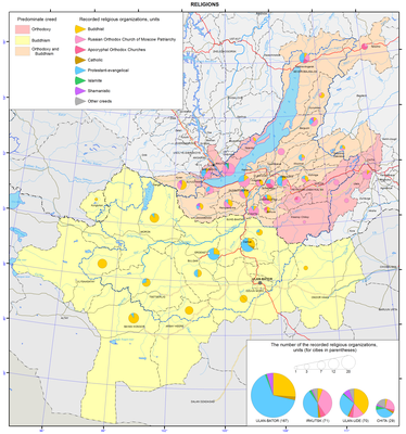
Religions
Traditional religions in the Baikal basin include Shamanism, Buddhism in the form of Lamaism, and Russian Orthodox Christianity. Current religious situation is, to a large measure, determined by political reforms that were carried out in Mongolia and Russia in the 1990s. Now, there are a plethora of religious denominations and practices.
The majority of the population is religious. In most cases, undecided and non-believers still associate themselves with a particular traditional religion. In Mongolia, for example, about 90% of the population identify themselves with Buddhism, while 6% - with Shamanism. On the other hand, according to the 2010 census, 61.4% of the population 15 years of age or older identified themselves as believers. Buddhists, Muslims, Shamanists, Christians and adherents of other religions constituted 53, 3, 3, 2, and <1%, respectively. In Buryatia, the most widespread self-identifications are with two religions: Buddhism and Russian Orthodox Christianity. In Zabaikalsky krai and Irkutsk oblast, the overwhelming majority of the people identify themselves as Russian Orthodox Christians, whereas Buddhism holds the lead in Tuva. According to the opinion poll data collected in 2012 by the Nonprofit Research Service “Sreda”, the proportion of residents professing Buddhism in the aforementioned regions constituted, respectively, 20; 6; <1; 62; Christianity: 32; 32; 48; 2 (including Russian Orthodox: 27; 25; 41; 1), Islam: <1; <1; 7; ; <1; Shamanism: 2; <1; 1; 8; and other religions: <1; <1;<1; <1%.
Although religious organizations must register, there are some unregistered groups. They steadily grow in number with the fastest growth among Protestant and Evangelical groups.
The population is tolerant toward different religions. Contradictory and mixed religious views often coexist.
Buddhism in the Baikal basin (its concepts, rites, rituals, mythology, and spirits) was influenced by the religious customs that had existed before it was introduced in this region.
Buddhist monasteries take an important place in the social (and ecological) life. They organize the dialog with science and education. Not only Buddhist monks, but also secular specialists are invited to give lectures at monasteries. Publishing is a major activity of monastic centers. Much attention is given to the formation and preservation of the cultural memory of the people, as well as to the issues related to the adjustment of the Buddhist teaching to current conditions and its further development, including among the ethnically Russian population.
Christianity in the Russian part of the Baikal basin is mostly represented by the Russian Orthodox Church. In the Mongolian part of the basin, it is mainly Protestant and Evangelical organizations (90% Protestants, mainly Evangelicals and Baptists, 9% Mormons, 1% Catholics and Russian Orthodox believers).
Christianity views the resolution of environmental issues as a component of the ministerial and missionary services to God. According to the Bible, everything on Earth was created by God. Nature was created to satisfy human needs. However, it is not just a reservoir of resources for egoistic and irresponsible consumption, but a temple, in which an individual serves God. The individual is responsible for his/her thoughts and acts and must treat the nature with care. Life in all its different manifestations has a sacred character; its destruction or disturbance is a challenge to God.
According to Christianity, ecological problems are the consequences of egoistic and consumer impulses. Therefore, ecological activity will fail to reach the desired results, unless people begin to live by Christian commandments.
Islam (mostly Sunni Islam) has an ethnic character. In the Russian territory, the majority of Muslims are ethnic Tatars. In Mongolia, they are the not-so-numerous Kazakhs, Uzbeks, Uighurs, Tatars, and other Muslim ethnicities.
According to the Quran, the Man and the Nature are the great sacred creations of Allah. People are responsible for the preservation, purity, and beauty of the nature. All living beings on Earth are like the Man. Torturing them is absolutely prohibited. Any good done to an animal is equally beneficial as any good done to the Man. The efforts of the Man to do good to the nature is regarded as a virtue, which helps him or her gain blessings and Paradise in the future life.
Islam pays much attention to the improvement in the condition of Earth with human hands. It poses the question about the union of science and religion in dealing with environmental problems.
Shamanism is the oldest religion of Siberia and Central Asia. It is thought to be originated on Olkhon Island (on Lake Baikal), which is considered to be a sacred place. According to the concepts of Shamanism, there are three worlds: upper (heavenly), middle (terrestrial), and lower (subterranean). Nowadays, Shamanism also includes the followers of Tengrism, a global religion, which demonstrates a tendency towards a philosophical-metaphysical monotheism practiced by early nomadic communities in Mongolia.
A careful use of natural resources is based on the cultural and religious traditions. Local natural sites play an important role in the concepts of the universe. Previously, Shamanism “served” the communal-tribal sphere, and each tribe and clan had their own sacred places, where rituals were conducted. In such places, they built ovoos and tied ribbons to tree branches.
The ecological concepts of other religions in the Baikal basin are also directed towards nature conservation.
According to all religions, the resolution of environmental problems must begin with the spiritual and moral improvement of human beings.
