Atlas
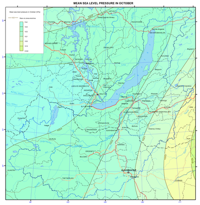
016. Mean sea level pressure in October map
Climate
Observational data of meteorological stations on the air temperature and precipitation in the period of 1961 to 2008 serve as initial data for climate maps here. Mean monthly and annual values are considered.
Atmospheric pressure
A primary role in shaping climate is played by atmospheric circulation - one of the main climate factors. Atmospheric circulation is presented in the maps of pressure fields in the central months of seasons. The maps are compiled based on the monthly mean pressure values reduced to sea level (NCEP / NCAR reanalysis base). In winter, the main pressure system at the surface is Asian (Siberian) anticyclone centered on the north-west of Mongolia, reaching maximum development in January. In spring, the action of the Asian maximum weakens. Differences in the properties of the underlying surface of the continent and ocean reduce dramatically, thereby the zonal circulation factors begin to dominate, that determine the west-east transport. Together with the transfer of pressure formations from west to east the cyclones outputs from Central Asia and Kazakhstan are observed in spring. Summer circulation processes are characterized by the weakening of the west-east transport. The pressure field of low pressure dominates at the earth's surface. Circulation processes are characterized by the weakening of the west-east transport. At the earth's surface the pressure field of low pressure with light winds dominates. When the blocking warm anticyclone locates over the central regions of Yakutia, south cyclones from Mongolia move to the Baikal region and then they slowly travel to the west or northwest. Central forms of summer circulation, which are characterized by blockage of the zonal flow and split of planetary altitude frontal zone (PAFZ) of temperate latitudes, occur conditioned upon intensive development of the typical summer tall crests and troughs. Circulation conditions of the autumn period are characterized by the development of general west-east transport, which is interrupted by meridional invasions of cold air masses from the north. Siberian anticyclone is in its formation stage. Compared with the spring season the autumn west-east movement of pressure systems is slower. Final transition to winter conditions of circulation takes place around the middle of November, when the Siberian anticyclone is sufficiently stable.
Document Actions
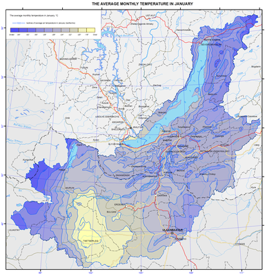
017. The average monthly temperature in January map
Air temperature
Lake Baikal influences the climate of the surrounding area within the Baikal hollow. The climate of inland areas of Irkutsk oblast, Republic of Buryatia, Zabaikalsky krai, and Mongolia may be called sharply continental, and the climate of the shore of Lake Baikal is close to the coastal one. Winter month’s temperature on the shores of southern Baikal is on average 5°C higher than in the central areas, and summer month’s temperature is lower at the same rate. In summer temperature inversions are observed over the cold lake surface that impedes upward motions. The set of radiation and circulating factors and local conditions determine the features of the thermal regime.
In winter, due to the predominance of anticyclonic weather, the air temperature depends mainly on the radiation conditions, and the air cools over the underlying surface. In summer, radiation factors also play a dominant role in the temperature regime formation.
Long-term mean annual temperature is almost everywhere negative. At stations located on the shores of Lake Baikal, air temperature is higher than on the continental stations located at the same latitudes. The coldest month is January, and the warmest one is July.
Document Actions
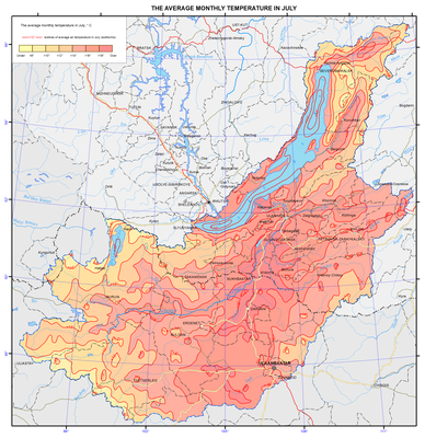
018. The average monthly temperature in July map
Air temperature
Lake Baikal influences the climate of the surrounding area within the Baikal hollow. The climate of inland areas of Irkutsk oblast, Republic of Buryatia, Zabaikalsky krai, and Mongolia may be called sharply continental, and the climate of the shore of Lake Baikal is close to the coastal one. Winter month’s temperature on the shores of southern Baikal is on average 5°C higher than in the central areas, and summer month’s temperature is lower at the same rate. In summer temperature inversions are observed over the cold lake surface that impedes upward motions. The set of radiation and circulating factors and local conditions determine the features of the thermal regime.
In winter, due to the predominance of anticyclonic weather, the air temperature depends mainly on the radiation conditions, and the air cools over the underlying surface. In summer, radiation factors also play a dominant role in the temperature regime formation.
Long-term mean annual temperature is almost everywhere negative. At stations located on the shores of Lake Baikal, air temperature is higher than on the continental stations located at the same latitudes. The coldest month is January, and the warmest one is July.
