Atlas
007. Seismic risk zoning map
Seismic zoning. Epicenters of strong earthquakes
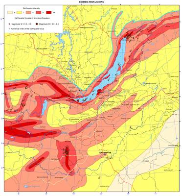
Seismic zoning implies mapping of seismic risk due to maximum seismic impact, which might originate over this area and be exceeded with a certain probability during the assigned time interval [Ulomov and Bogdanov, 2013].
Total seismic zoning (TSZ) is implemented on the basis of studying regional and global seismicity-generating structures (SGS), determining recent geodynamics, seismicity and seismic regime over territories of states. TSZ serves as the foundation for a rational land use and securing the antiseismic construction. To specify the degree of seismic risk in appropriate regions and over the local areas the supplementary field surveys are performed, including instrumental surveys.
The map of seismic zoning over the territory of the Lake Baikal catchment area depicts the materials collected through a systematic study of active faults within the territories of Cisbaikalia and Mongolia, where the strongest earthquakes might be the case. This type of mapping is methodologically based on the geological and geophysical evidence specifying the features of seismic and tectonic development of the territory including the elements of historic-structural, tectonophysic and paleo-seismic approaches applied for recognizing the zones of probable earthquake foci (PEF). The main goal of identified PEF zones is a maximally reality-approached reflection of projections of future focal zones of earthquakes of varying magnitude (М) occurring with a certain repeatability. Construction of PEF zones also includes extrapolation of possible M of earthquakes occurred in known geologic-geophysical environs onto the morphology-structural fault complexes with similar conditions, but in which the respective earthquakes have not taken place yet. This seismotectonic approach proposed by I.E. Gubin (1950) is applicable so far. On the map of seismic zoning from PEF zones with a certain seismic potential (М of an earthquake), according to a decay of seismic waves from quake epicenters, seismic zones are outlined following the MSK-64 intensity scale units [New map …., 1996; Recent geodynamics…, 1996].
The map of seismic zoning may be regarded as the long-term prognosis of strong earthquakes during 1000 years. The map was based on seismic statistical data on the seismicity recorded over the regional territory for over 100 years period of observations, as well as seismogeological evidence and maps of active faults [Smekalin et al., 2011].
The main goal of the map of seismic zoning is to reflect the realistic level of seismic risk as a magnitude in each point of the surveyed territory considering the quantification of the boundaries of regions with different seismic risk measured in probabilistic values.
The map representing modern concepts of seismogeological analysis developed by seismologists of Irkutsk [Seismic zoning…, 1977] distinctly displays a linear elongated mode of isolines with different seismic risk expressed in magnitude. This is because configuration of all these lines lies upon seismic lineaments. They represent the axes of the upper edges of 3D seismically active fault structures, related structured seismicity and framework of the lineament-domain-focal (LDF) model applied in this study.
The entire area of the Baikal basin is outlined by the intensity 7 to 9 isolines of seismic risk. As this takes place, the narrow linear zones of possible quakes with intensity 10 (on the map intensity >9) are common for the southern termination of the lake basin, and they are associated with the Main Sayan fault and numerous paleo-seismic dislocations located nearby. The paleo events, they are related to, could generate quakes with intensity 10 to 11. The other similar spot of quakes with intensity 10 is located in the north of the lake, in the region of the Kichera paleo dislocations occurring within the Kichera seismically active faults capable to generate earthquakes with magnitude М= 7.0 – 7.5. The third spot in the Selenga river delta is linked with the Delta seismically active fault, its plane comprising the focus of the catastrophic Tsagan earthquake of 1862 with М=7.5 (with the M=10 effects observed on the surface). All the water area of Lake Baikal is contoured by the M=9 isoseism.
The isoline of M=8 intensity turns over M=9 isoseisms and extends in the north-eastern direction on both sides from Lake Baikal. This area includes such large populated localities as the cities of Irkutsk, Ulan-Ude and Ulaanbaatar. Over the Mongolian territory, to the south of Lake Khovsgol, there is a sublatitudinal zone of M=10 quakes (intensity > 9 on the map), associated with the area of two faults, in which planes the foci of the Bolnay and Tsetserleg earthquakes of 1905 occur. These seismic events are referred to the strongest intra-continent earthquakes on the Earth of instrumental period (М=8.5, intensity 11-12). Lake Khovsgol and adjacent territories lie within the zone of intensity-9 quakes.
The city of Ulaanbaatar sits within the zone with seismic effect of intensity-8 quakes. This zone is contoured on both sides by M=7 isoseisms stretching northeastward to the city of Chita. The area of possible intensity-7 quakes extends from Ulan-Ude in the north to Sukhe-Baatar (Mongolia) in the south.
These materials were used as the basis to construct a new map of seismic zoning over the RF territory TSZ-2012, which in the future will become the normative and reference document for all research and design project organizations of Russia [Ulomov, Bogdanov, 2013].
References
Gubin, I. Е. (1950). Seismotectonic approach of seismic zoning. Moscow-Leningrad: Izd-vo AN SSSR, 63 p.
New map of seismic zoning of the North Eurasia territory. (1996) // V. S. Khromovskikh, V. V. Nikolaev, М.G.. Dem’yanovich, А. V. Chipizubov, R. М. Semenov, S. P. Serebrennikov, S. G.. Arzhannikov, О. P. Smekalin, and Е. А. Del’yanskii. In: Geophysical Research in Eastern Siberia at the turn of the 21st century. Novosibirsk: Nauka, pp. 94-99.
Seismic zoning of Eastern Siberia and its geologo-geophysical fundamentals. (1977). Ed. Solonenko V. P. Novosibirsk: Nauka,.
Smekalin, О. P., Imaev, V. S., and Chipizubov, А. V. (2011). Paleoseismology of Eastern Siberia. Irkutsk: Izd-vo IZK SO RAN, 98 p.
Recent geodynamics: seismotectonics, earthquake prognosis, seismic risk (fundamental and applied aspects) (1996) // Levi, K. G., Khromovskikh, V. S., Kochetkov, V. М., Nikolaev, V. V., Semenov, R. М., Serebrennikov, S. P., Chipizubov, А. V., Dem’yanovich, М. G., Arzhannikov, S. G., Zhel’yanskii, E. A., Smekalin, O. P., Ruzhich, V. V., Buddo, V. Yu., Massal’skii, O. K., Potapov, V. А., Berzhinskii, Yu. A., Radziminovich, Ya. B. In: Lithosphere of Central Asia. Irkutsk: Izd-vo IZK SO RAN, pp. 150-183.
Ulomov, V. I. and Bogdanov, M. I. (2013). New set of maps of total seismic zoning on the RF territory TSZ-2012, Inzhenernye izyskaniya, , no. 8, pp. 8-17.
Document Actions
008. Relief map
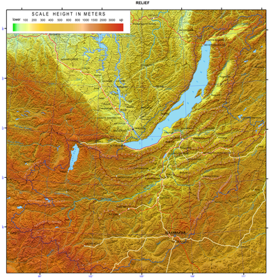
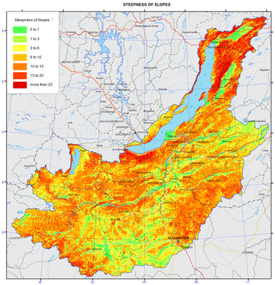
Geomorphology
The Baikal basin is located in the center of Eurasia, which determines its specific traits as well as the main features of nature. Paleogeography and geology of the region govern its peculiar landforms.
Vertical tectonic movements of the Late Mesozoic and the Cenozoic developed a mountain-basin type of topography.
The orographic structure of the Baikal basin is rather complex. The topography as a whole is a unified Pliocene-Quaternary formation [Ecosystems, 2005]. Significant subsidence of individual blocks in the midst of general uplift developed grabens of two types. The first type (the Baikal type) is associated with the intensification of tectonic activity in the inland Baikal Rift Zone. The amplitude of vertical neotectonic movements, as well as the thickness of loose deposits reach their maximum here. Crustal movements in this area are still quite intense; they cause a high seismic activity with frequent and sometimes strong earthquakes. The second type (the Transbaikalian type) is represented by wide intermountain lowlands, which are very common in the Selenga river basin. They formed as a result of recent deep-seated tectonic dislocations superimposed on the rejuvenated Mesozoic depressions.
Intermountain basins are separated by mountain ranges varying in height and geological structure. They are noticeably dissected by exogenous processes of erosion.
In the Quaternary, the highest orographic units (the Baikalsky, Verkhneangarsky, Barguzinsky, Khamar-Daban, Khangai and other mountain ranges), especially their north-western and northern slopes, were exposed to glaciation, which is indicated by the presence of the alpine landforms (cirques, avalanche chutes, through valleys, moraines, etc.)
Both positive and negative landforms within the Selenga river catchment area basin and up to the Uda river mouth are generally directed northeastward with a dominant altitude lowering northward. The mountains surrounding of three Baikal intermountain basins (Barguzin, Verkhneangarsk and Khovsgol lowlands) are characterized by higher absolute altitudes and deeply cut river valleys. These factors predetermine a wide range of elements typical of mountain landform, or plain landform in the wide intermountain basins.
According to the geomorphological zoning [Highlands…, 1974; National Atlas of the Mongolian People’s Republic, 1990] the area of the Baikal basin is made up of the following features: Khangai and Khentei-Dauria highlands, Khovsgol mountains, Orkhon-Selenga middle mountains and its continuation in the north - Selenga (Selenginskaya Dauria) middle mountains, mountain systems of the Dzhidinsky mountainous region, mountain ranges of Khamar-Daban, Ulan-Burgasy, Ikatsky, Barguzinsky, Verkhneangarsky, Severomuisky, Baikalsky, and Primorsky, and the western side of the Vitim Plateau. Minimum absolute altitude is the Lake Baikal waterline; since it is regulated, it is subjected to slight fluctuations at around 460 m a.s.l. Maximum absolute altitude is 3,539 m a.s.l. (the Khangai Highland).
The highest mountain range in the area is the Khangai Highland located in the south-western part of the basin; it has generally subdued delineation and slight changes of relative altitudes. The mountains become more prominent towards the central part of the basin due to Alpine landforms. Tarbagatai and Telin-Tsagan are the largest northern spurs of Khangai Highlands with individual peaks reaching 2,500 m.
The maximum altitudes of the Khentei Highland mountains go up to 2,200-2,400 m a.s.l. Their wide and long spurs stretch westward and eastward, forming a large highland, gradually descending to low hills in the west and in the south, and joining the mountains of Transbaikalia in the north. Generally, this is a gently sloping landscape with wide-spread residual hills, rocks, and scattered stones. Traces of ancient glaciation are preserved to a limited extent.
The Orkhon-Selenga middle mountains are located in the central part of the watershed basin between the ranges of the Dzhida river basin in the north and the Khentei Highlands in the south. It features a flattened relief and its spatial configuration resembles a huge amphitheater descending towards the northeast.
The Selenga middle mountains consist of sublatitudinal medium-altitude mountain ranges with rounded summits (Tsagan-Daban, Borgoisky, Chikoysky, Tsagan-Khurteisky, Zagansky, and others) separated by wide intermountain valleys distinctly stretching along the main riverbeds. The valley bottoms are drained by the Selenga tributaries (Chikoy, Khilok, Uda, Dzhida) and composed of alluvial and proluvial deposits of different age arranged in terraces and wide piedmont plains. The Selenga river valley lies among low hills with granite residuals, rocks, and cliffs.
The Khovsgol area relief has a complex structure. Its west side features sharp-crested, steep-sided, and hard to access ridges of Bayan-Ula and Khoridol-Saryag. The outlines of the mountains to the east of Lake Khovsgol resemble those of the northern Khentei with altitudes over 2,000 m. Extensive Late Cenosoic lava plateaus are specific features of these mountains.
The Dzhida and Khamar-Damban Mountain Ranges have a lot in common. They stretch from the south-west to the north-east. In the west, they are relatively flattened and marked by bald peaks, gradually turning into the alpinotype middle mountains of the Big Khamar-Daban Mountain Range, which drops steeply to the shores of Lake Baikal. In the east, the mountains have a lower altitude. The Selenga river cuts through their spurs.
The northern part of Lake Baikal and the Verkhneangarskaya basin are surrounded by Alpine landforms with harsh outlines of the axial and piedmont parts of the Baikalsky, Verkhneangarsky, Severomuisky, and Barguzinsky mountain ranges. In spite of the relatively moderate elevations, there are many glacial traces here, and in some places there are small vanishing mountain glaciers (e.g. the Chersky Glacier – about 0.4 km2) The Vekhneangarsky basin relief shows little elevation changes at the bottom. It is formed by the alluvial deposits of the Verkhnyaya Angara (the Upper Angara) river, and by lacustrine alluvial deposits of paleobasins. Extensive proluvial and fluvioglacial piedmont plains are typical of the basin.
The structure of the Barguzinskya basin is typical of the Baikal-type depressions: large swampy plain areas at the basin bottom, and relatively uplifted ancient alluvial lacustrine terraces made of sandstone deposits. The presence of large areas of sandstone deposits predetermines high eolian activity.
In the south, the Barguzinskaya depression is framed by massive, but relatively flat landforms of the Ikatsky range. The highest summits of the Ikatsky range as well as those of the ranges lying further south (Ulan-Burgasy and Kurbinsky ranges) are treeless and flat with mountain terraces.
References
Logachev, N.A., Antoshchenko-Olenev, I.V., Bazarov, D.B. et al. (1974). Highlands of Cisbaikalia and Transbaikalia. Moscow: Nauka, 360 p.
Ecosystems of the Selenga basin (Biological Resources and Natural Conditions of Mongolia: Proceedings of the Joint Russian-Mongolian Complex Biological Expedition; vol. 44), (2005). Executive Editors: E.A. Vostokova and P.D. Gunin. Moscow: Nauka, 359 p.
Document Actions
009. Steepness of slopes map
Geomorphology map. Orographic scheme
The Baikal basin is located in the center of Eurasia, which determines its specific traits as well as the main features of nature. Paleogeography and geology of the region govern its peculiar landforms.
Vertical tectonic movements of the Late Mesozoic and the Cenozoic developed a mountain-basin type of topography.
The orographic structure of the Baikal basin is rather complex. The topography as a whole is a unified Pliocene-Quaternary formation [Ecosystems, 2005]. Significant subsidence of individual blocks in the midst of general uplift developed grabens of two types. The first type (the Baikal type) is associated with the intensification of tectonic activity in the inland Baikal Rift Zone. The amplitude of vertical neotectonic movements, as well as the thickness of loose deposits reach their maximum here. Crustal movements in this area are still quite intense; they cause a high seismic activity with frequent and sometimes strong earthquakes. The second type (the Transbaikalian type) is represented by wide intermountain lowlands, which are very common in the Selenga river basin. They formed as a result of recent deep-seated tectonic dislocations superimposed on the rejuvenated Mesozoic depressions.
Intermountain basins are separated by mountain ranges varying in height and geological structure. They are noticeably dissected by exogenous processes of erosion.
In the Quaternary, the highest orographic units (the Baikalsky, Verkhneangarsky, Barguzinsky, Khamar-Daban, Khangai and other mountain ranges), especially their north-western and northern slopes, were exposed to glaciation, which is indicated by the presence of the alpine landforms (cirques, avalanche chutes, through valleys, moraines, etc.)
Both positive and negative landforms within the Selenga river catchment area basin and up to the Uda river mouth are generally directed northeastward with a dominant altitude lowering northward. The mountains surrounding of three Baikal intermountain basins (Barguzin, Verkhneangarsk and Khovsgol lowlands) are characterized by higher absolute altitudes and deeply cut river valleys. These factors predetermine a wide range of elements typical of mountain landform, or plain landform in the wide intermountain basins.
According to the geomorphological zoning [Highlands…, 1974; National Atlas of the Mongolian People’s Republic, 1990] the area of the Baikal basin is made up of the following features: Khangai and Khentei-Dauria highlands, Khovsgol mountains, Orkhon-Selenga middle mountains and its continuation in the north - Selenga (Selenginskaya Dauria) middle mountains, mountain systems of the Dzhidinsky mountainous region, mountain ranges of Khamar-Daban, Ulan-Burgasy, Ikatsky, Barguzinsky, Verkhneangarsky, Severomuisky, Baikalsky, and Primorsky, and the western side of the Vitim Plateau. Minimum absolute altitude is the Lake Baikal waterline; since it is regulated, it is subjected to slight fluctuations at around 460 m a.s.l. Maximum absolute altitude is 3,539 m a.s.l. (the Khangai Highland).
The highest mountain range in the area is the Khangai Highland located in the south-western part of the basin; it has generally subdued delineation and slight changes of relative altitudes. The mountains become more prominent towards the central part of the basin due to Alpine landforms. Tarbagatai and Telin-Tsagan are the largest northern spurs of Khangai Highlands with individual peaks reaching 2,500 m.
The maximum altitudes of the Khentei Highland mountains go up to 2,200-2,400 m a.s.l. Their wide and long spurs stretch westward and eastward, forming a large highland, gradually descending to low hills in the west and in the south, and joining the mountains of Transbaikalia in the north. Generally, this is a gently sloping landscape with wide-spread residual hills, rocks, and scattered stones. Traces of ancient glaciation are preserved to a limited extent.
The Orkhon-Selenga middle mountains are located in the central part of the watershed basin between the ranges of the Dzhida river basin in the north and the Khentei Highlands in the south. It features a flattened relief and its spatial configuration resembles a huge amphitheater descending towards the northeast.
The Selenga middle mountains consist of sublatitudinal medium-altitude mountain ranges with rounded summits (Tsagan-Daban, Borgoisky, Chikoysky, Tsagan-Khurteisky, Zagansky, and others) separated by wide intermountain valleys distinctly stretching along the main riverbeds. The valley bottoms are drained by the Selenga tributaries (Chikoy, Khilok, Uda, Dzhida) and composed of alluvial and proluvial deposits of different age arranged in terraces and wide piedmont plains. The Selenga river valley lies among low hills with granite residuals, rocks, and cliffs.
The Khovsgol area relief has a complex structure. Its west side features sharp-crested, steep-sided, and hard to access ridges of Bayan-Ula and Khoridol-Saryag. The outlines of the mountains to the east of Lake Khovsgol resemble those of the northern Khentei with altitudes over 2,000 m. Extensive Late Cenosoic lava plateaus are specific features of these mountains.
The Dzhida and Khamar-Damban Mountain Ranges have a lot in common. They stretch from the south-west to the north-east. In the west, they are relatively flattened and marked by bald peaks, gradually turning into the alpinotype middle mountains of the Big Khamar-Daban Mountain Range, which drops steeply to the shores of Lake Baikal. In the east, the mountains have a lower altitude. The Selenga river cuts through their spurs.
The northern part of Lake Baikal and the Verkhneangarskaya basin are surrounded by Alpine landforms with harsh outlines of the axial and piedmont parts of the Baikalsky, Verkhneangarsky, Severomuisky, and Barguzinsky mountain ranges. In spite of the relatively moderate elevations, there are many glacial traces here, and in some places there are small vanishing mountain glaciers (e.g. the Chersky Glacier – about 0.4 km2) The Vekhneangarsky basin relief shows little elevation changes at the bottom. It is formed by the alluvial deposits of the Verkhnyaya Angara (the Upper Angara) river, and by lacustrine alluvial deposits of paleobasins. Extensive proluvial and fluvioglacial piedmont plains are typical of the basin.
The structure of the Barguzinskya basin is typical of the Baikal-type depressions: large swampy plain areas at the basin bottom, and relatively uplifted ancient alluvial lacustrine terraces made of sandstone deposits. The presence of large areas of sandstone deposits predetermines high eolian activity.
In the south, the Barguzinskaya depression is framed by massive, but relatively flat landforms of the Ikatsky range. The highest summits of the Ikatsky range as well as those of the ranges lying further south (Ulan-Burgasy and Kurbinsky ranges) are treeless and flat with mountain terraces.
References
Logachev, N.A., Antoshchenko-Olenev, I.V., Bazarov, D.B. et al. (1974). Highlands of Cisbaikalia and Transbaikalia. Moscow: Nauka, 360 p.
Ecosystems of the Selenga basin (Biological Resources and Natural Conditions of Mongolia: Proceedings of the Joint Russian-Mongolian Complex Biological Expedition; vol. 44), (2005). Executive Editors: E.A. Vostokova and P.D. Gunin. Moscow: Nauka, 359 p.
