<?xml version="1.0" encoding="utf-8" ?>
<rdf:RDF xmlns:rdf="http://www.w3.org/1999/02/22-rdf-syntax-ns#" xmlns:dc="http://purl.org/dc/elements/1.1/" xmlns:syn="http://purl.org/rss/1.0/modules/syndication/" xmlns="http://purl.org/rss/1.0/">


<channel rdf:about="http://bic.iwlearn.org/en/search_rss">
  <title>English</title>
  <link>http://bic.iwlearn.org</link>

  <description>
    
            These are the search results for the query, showing results 21 to 35.
        
  </description>


  <image rdf:resource="http://bic.iwlearn.org/logo.png"/>

  <items>
    <rdf:Seq>
      
        <rdf:li rdf:resource="http://bic.iwlearn.org/en/documents/documents/papers/groundwater-use-in-the-selenge-river-basin-mongolia-english"/>
      
      
        <rdf:li rdf:resource="http://bic.iwlearn.org/en/documents/documents/papers/hydrological-regime-analysis-of-the-selenge-river-basin-mongolia-english"/>
      
      
        <rdf:li rdf:resource="http://bic.iwlearn.org/en/documents/documents/complex-reports/bic-conception-for-mongolia-english"/>
      
      
        <rdf:li rdf:resource="http://bic.iwlearn.org/en/documents/documents/complex-reports/reports-of-the-un-experts-mission-to-khongor-sum-darkhan-uul-aimag-mongolia-english"/>
      
      
        <rdf:li rdf:resource="http://bic.iwlearn.org/en/documents/documents/complex-reports/2013/baikal-basin-transboundry-diagnostic-analysis"/>
      
      
        <rdf:li rdf:resource="http://bic.iwlearn.org/en/atlas/atlas/03-lake-baikal-basin-borders-and-structure-map/lake-baikal-basin-borders-and-structure-map"/>
      
      
        <rdf:li rdf:resource="http://bic.iwlearn.org/en/atlas/atlas/about-the-project/about-the-project-1"/>
      
      
        <rdf:li rdf:resource="http://bic.iwlearn.org/en/atlas/atlas/142-aesthetic-image-of-the-baikal-shore-map/aesthetic-image-of-the-baikal-shore-map"/>
      
      
        <rdf:li rdf:resource="http://bic.iwlearn.org/en/atlas/atlas/142-aesthetic-image-of-the-baikal-shore-map"/>
      
      
        <rdf:li rdf:resource="http://bic.iwlearn.org/en/atlas/atlas/141-natural-managment-and-environmental-condition-of-central-ecological-zone-map/natural-managment-and-environmental-condition-of-central-ecological-zone-map"/>
      
      
        <rdf:li rdf:resource="http://bic.iwlearn.org/en/atlas/atlas/141-natural-managment-and-environmental-condition-of-central-ecological-zone-map"/>
      
      
        <rdf:li rdf:resource="http://bic.iwlearn.org/en/atlas/atlas/140-recreation-on-lake-baikal-shores-map/recreation-on-lake-baikal-shores-map"/>
      
      
        <rdf:li rdf:resource="http://bic.iwlearn.org/en/atlas/atlas/140-recreation-on-lake-baikal-shores-map"/>
      
      
        <rdf:li rdf:resource="http://bic.iwlearn.org/en/atlas/atlas/139-distribution-omul-map/distribution-omul-map"/>
      
      
        <rdf:li rdf:resource="http://bic.iwlearn.org/en/atlas/atlas/139-distribution-omul-map"/>
      
    </rdf:Seq>
  </items>

</channel>


  <item rdf:about="http://bic.iwlearn.org/en/documents/documents/papers/groundwater-use-in-the-selenge-river-basin-mongolia-english">
    <title>Groundwater use in the Selenge river basin, MONGOLIA (English)</title>
    <link>http://bic.iwlearn.org/en/documents/documents/papers/groundwater-use-in-the-selenge-river-basin-mongolia-english</link>
    <description></description>
    
    <dc:publisher>No publisher</dc:publisher>
    <dc:creator>puntsagsurenchoimpog@yahoo.com</dc:creator>
    <dc:rights></dc:rights>
    <dc:date>2014-12-26T07:12:22Z</dc:date>
    <dc:type>File</dc:type>
  </item>


  <item rdf:about="http://bic.iwlearn.org/en/documents/documents/papers/hydrological-regime-analysis-of-the-selenge-river-basin-mongolia-english">
    <title>Hydrological regime analysis of the Selenge River basin, Mongolia (English)</title>
    <link>http://bic.iwlearn.org/en/documents/documents/papers/hydrological-regime-analysis-of-the-selenge-river-basin-mongolia-english</link>
    <description></description>
    
    <dc:publisher>No publisher</dc:publisher>
    <dc:creator>puntsagsurenchoimpog@yahoo.com</dc:creator>
    <dc:rights></dc:rights>
    <dc:date>2014-12-26T01:31:51Z</dc:date>
    <dc:type>File</dc:type>
  </item>


  <item rdf:about="http://bic.iwlearn.org/en/documents/documents/complex-reports/bic-conception-for-mongolia-english">
    <title>BIC Conception for Mongolia (English)</title>
    <link>http://bic.iwlearn.org/en/documents/documents/complex-reports/bic-conception-for-mongolia-english</link>
    <description></description>
    
    <dc:publisher>No publisher</dc:publisher>
    <dc:creator>puntsagsurenchoimpog@yahoo.com</dc:creator>
    <dc:rights></dc:rights>
    <dc:date>2014-12-25T02:10:14Z</dc:date>
    <dc:type>File</dc:type>
  </item>


  <item rdf:about="http://bic.iwlearn.org/en/documents/documents/complex-reports/reports-of-the-un-experts-mission-to-khongor-sum-darkhan-uul-aimag-mongolia-english">
    <title>Reports of the UN experts' mission to Khongor sum, Darkhan-Uul aimag, MONGOLIA (English)</title>
    <link>http://bic.iwlearn.org/en/documents/documents/complex-reports/reports-of-the-un-experts-mission-to-khongor-sum-darkhan-uul-aimag-mongolia-english</link>
    <description></description>
    
    <dc:publisher>No publisher</dc:publisher>
    <dc:creator>puntsagsurenchoimpog@yahoo.com</dc:creator>
    <dc:rights></dc:rights>
    <dc:date>2014-12-25T01:52:47Z</dc:date>
    <dc:type>File</dc:type>
  </item>


  <item rdf:about="http://bic.iwlearn.org/en/documents/documents/complex-reports/2013/baikal-basin-transboundry-diagnostic-analysis">
    <title>Baikal basin transboundry diagnostic analysis</title>
    <link>http://bic.iwlearn.org/en/documents/documents/complex-reports/2013/baikal-basin-transboundry-diagnostic-analysis</link>
    <description></description>
    
    <dc:publisher>No publisher</dc:publisher>
    <dc:creator>puntsagsurenchoimpog@yahoo.com</dc:creator>
    <dc:rights></dc:rights>
    <dc:date>2014-12-21T13:37:48Z</dc:date>
    <dc:type>File</dc:type>
  </item>


  <item rdf:about="http://bic.iwlearn.org/en/atlas/atlas/03-lake-baikal-basin-borders-and-structure-map/lake-baikal-basin-borders-and-structure-map">
    <title>003. Lake Baikal basin borders and structure map</title>
    <link>http://bic.iwlearn.org/en/atlas/atlas/03-lake-baikal-basin-borders-and-structure-map/lake-baikal-basin-borders-and-structure-map</link>
    <description></description>
    <content:encoded xmlns:content="http://purl.org/rss/1.0/modules/content/"><![CDATA[<p><img class="image-inline" src="../../../../resolveuid/2a4350aa556d461fbd3f1cf4e29c0f43/@@images/image/preview" /></p>
<p><a href="http://bic.iwlearn.org/en/photos/copy_of__03_LakeBaikalbasinbordersandstructure.png" class="internal-link">Open full size</a></p>
<p class="a" style="text-align: justify; ">
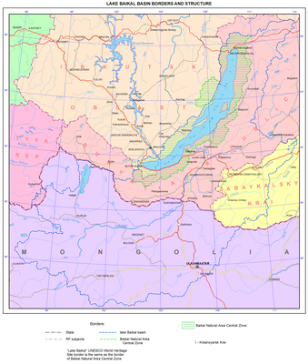
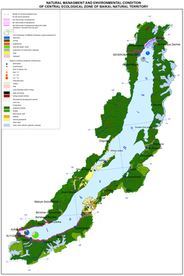
Patterns of territorial combinations of conditions and factors of the development of environmental problems in the Baikal basin are, to a large extent, determined by the basin’s location in the northern temperate latitudes of Eurasia, in its inner ultracontinental sector, and by its natural isolation from adjacent territories. The Baikal basin has all the features of the landscape and ecological integrity and economic and cultural unity. The region is home to one of the world's major watershed divides between the catchment areas of the Arctic Ocean (the Yenisei and Lena basins), Pacific Ocean (the Amur basin), and the drainless region of Central Asia. It is precisely here, on orographic barriers, where airflows from the Atlantic and Pacific Oceans, the Arctic, and southern territories subside.</p>
<p class="a" style="text-align: justify; ">
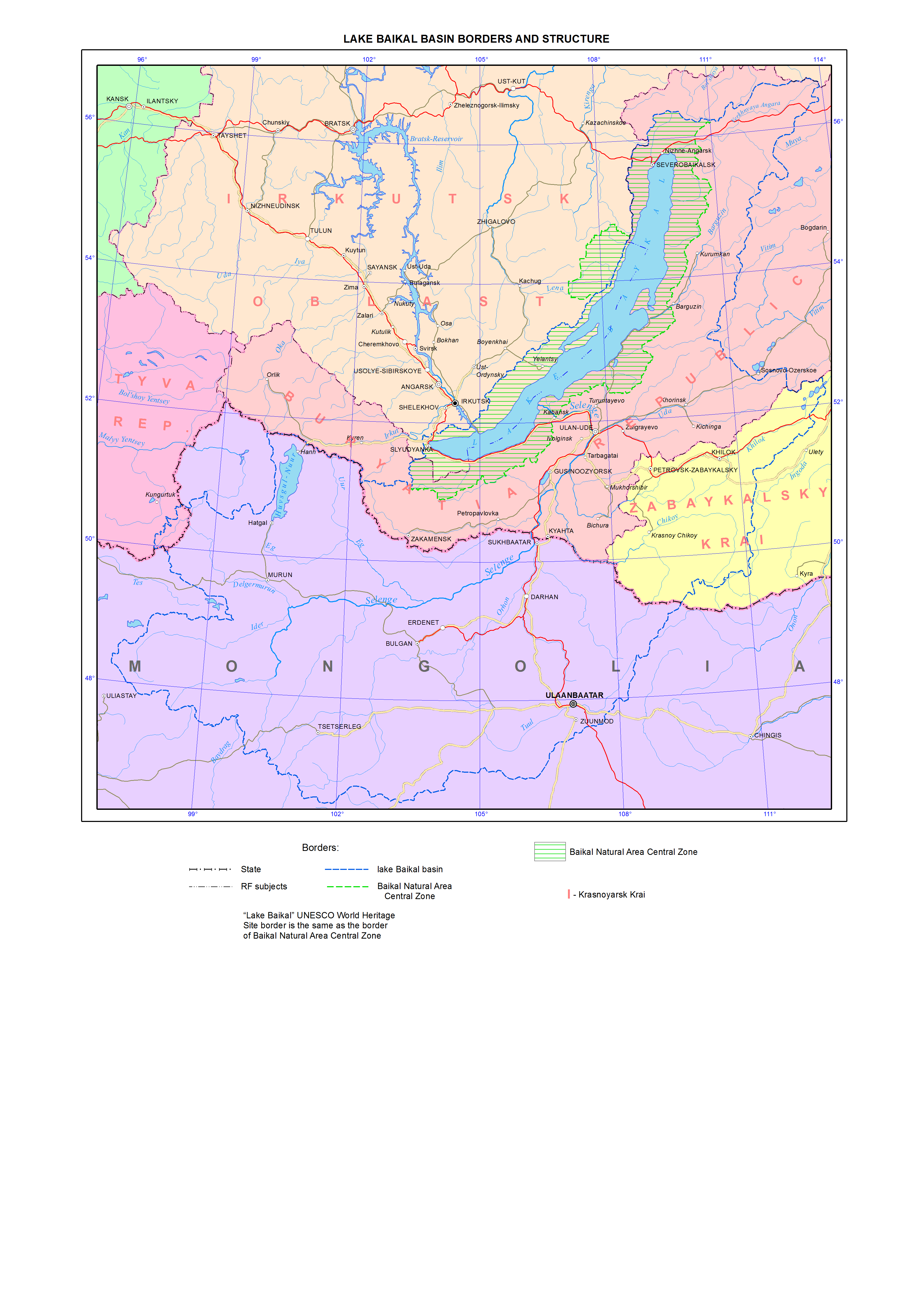
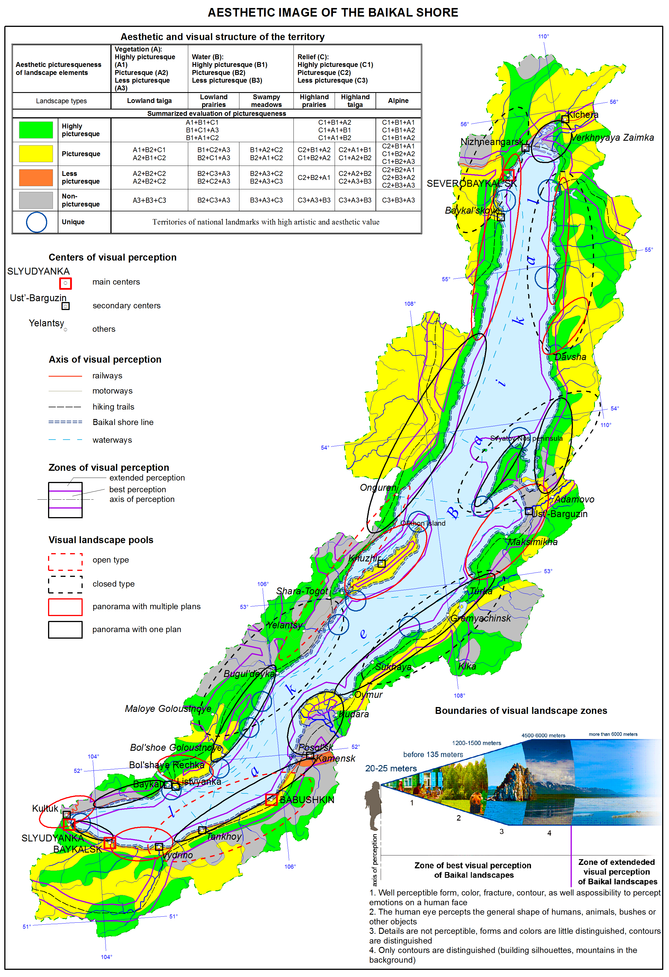
Lake Baikal is the oldest, deepest, and largest by volume lake among the great rift lakes of the world. The lake is situated at an elevation of 455.5 meters above sea level, between 51°28’ - 55°47’N and 103°43’ - 109°58’E. The Baikal basin's catchment area is located in the heart of Asia on the territory of two states – Russia and Mongolia - between 46°20’ - 56°40’N and 96°50’ - 114°10’E. It has an elongated shape stretching from southwest to northeast. The total area of the Baikal basin is 576.5 sq. km, including the water area of Lake Baikal - 31.7 sq. km. 44.6 % of the catchment area is located in the Russian Federation (31.8 % in the Republic of Buryatia, 10.2 % in Zabaikalsky krai, 2.2 % in Irkutsk oblast, and 0.4 % in the Republic of Tuva) and 55.4 % in Mongolia. About 53 % of the volume of river water is formed in Buryatia, 27 % in Mongolia, 16 % in Zabaikalsky krai, and 4 % in Irkutsk oblast.</p>
<p style="text-align: justify; ">
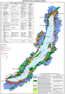
In general, due to its geographical and geopolitical location, as well as natural, resource, economic, ethnic, cultural, and human resources potential and the lake itself, the Baikal basin represents a key strategic region in eastern Russia and northern Mongolia - a major foothold for social and economic development of the two countries. However, such development has its own peculiarities, because the Baikal basin has a special regime of natural resources management. The fact that Lake Baikal and its surrounding territory was listed as a UNESCO World Heritage Site has attracted attention of the global community. It also underlined the role of the great lake as both a unique natural phenomenon and a place for establishing a recreation zone of the planetary significance, as well as a source of the exclusively eco-oriented land management and business in the future. Over the long term, in the context of the growing deficit of freshwater in the world, Lake Baikal’s water will become the most important strategic resource of the world. Therefore, the water factor of development is a priority. Reproduction and recovery of the lake’s water take place on the territory of the whole Baikal basin, which predetermines a particular attention towards nature protection in this region and dictates the prohibition of numerous types of production in order to prevent environmental pollution and preserve the Baikal water for humankind. Presently, the necessity of nature protection activities for maintaining the unmatched biological and landscape diversity of the lake's basin has emerged as a result of the intensive use of natural resources in different parts of the basin, where anthropogenic impact of varying degree and type is observed. Only responsible use of the complex of adaptive techniques and methods of organization of economic activity with due consideration to the special environmental and resource-related role and strategic importance of the Baikal region can make it, as early as in the first third of the 21st century, one of the full-fledged subjects of economic, geopolitical, and geo-demographic processes and relations of global significance. The Ecological Atlas of the Baikal Basin will be quite helpful in this endeavor. For the first time ever, the maps of this Atlas will reflect spatial patterns of the development of the environmental situation within the whole catchment basin of Lake Baikal and its water area, which makes it possible to define and substantiate the directions of environmentally balanced and sustainable territorial development of Russia and Mongolia in the future.</p>]]></content:encoded>
    <dc:publisher>No publisher</dc:publisher>
    <dc:creator>Alexander Ayurzhanaev</dc:creator>
    <dc:rights></dc:rights>
    <dc:date>2014-12-08T07:25:00Z</dc:date>
    <dc:type>Page</dc:type>
  </item>


  <item rdf:about="http://bic.iwlearn.org/en/atlas/atlas/about-the-project/about-the-project-1">
    <title>   About the project</title>
    <link>http://bic.iwlearn.org/en/atlas/atlas/about-the-project/about-the-project-1</link>
    <description></description>
    <content:encoded xmlns:content="http://purl.org/rss/1.0/modules/content/"><![CDATA[<p><img class="image-inline" src="../../../../resolveuid/919a5f09931346e38d46061930c14f29/@@images/image/preview" /></p>
<p><a href="http://bic.iwlearn.org/en/photos/0.png" class="internal-link">Open full size</a></p>
<p class="a"><strong>Editorial Council</strong></p>
<p class="a">N. S. KASIMOV</p>
<p class="a">M. V. SLIPENCHUK</p>
<p class="a">A. K. TULOKHONOV (Chair)</p>
<p class="a">V. M. PLYUSNIN (Deputy Chair)</p>
<p class="a">S. V. KUDELYA (Deputy Chair)</p>
<p class="a">S. ENKH-AMGALAN</p>
<p class="a">D. DORZHGOTOV</p>
<p class="a">S. OYUN</p>
<p class="a">B. TULGA</p>
<p class="a">Z. BATBOLD</p>
<p class="a">R. R. GIZATULIN</p>
<p class="a">A. M. AMIRKHANOV</p>
<p class="a">B. O. MAMAEV</p>
<p class="a">Z. TSOGTBAATAR</p>
<p class="a">O. E. KRAVCHUK</p>
<p class="a">O. A. POLYAKOV</p>
<p class="a">Y. P. SAFYANOV</p>
<p class="a">A. V. LBOV</p>
<p class="a">A. N. BESHENTSEV (Executive Secretary)</p>
<p class="a"> </p>
<p class="a"><strong>Editorial Board</strong></p>
<p class="a">V. M. PLYUSNIN, Dr.Sc. Geogr., (Co-chair, Editor-in-Chief)</p>
<p class="a">D. DORZHGOTOV, Academician of the Mongolian Academy of Sciences, (Co-chair)</p>
<p class="a">A. R. BATUEV, Dr.Sc. Geogr., (Deputy Chair, Executive Editor)</p>
<p class="a">E. Z. GARMAEV, Dr.Sc. Geogr., (Deputy Chair)</p>
<p class="a">L. M. KORYTNY, Dr.Sc. Geogr., (Deputy Chair, Executive Editor)</p>
<p class="a">Z. OYUUNGEREL, Dr.Sc. Geogr., (Deputy Chair, Executive Editor)</p>
<p class="a">V. S. TIKUNOV, Dr.Sc. Geogr., (Deputy Chair)</p>
<p class="a">D. ENKHTAIVAN, Dr.Sc. Geogr., (Deputy Chair, Executive Editor)</p>
<p class="a">V. N. BOGDANOV, Cand.Sc. Geogr., (Executive Secretary)</p>
<p class="a">A. V. ARGUCHINTSEVA, Dr.Sc. Tech.</p>
<p class="a">A. N. BESHENTSEV, Dr.Sc. Geogr.</p>
<p class="a">S. R. CHALOV, Cand.Sc. Geogr.</p>
<p class="a">I. A. BELOZERTSEVA, Cand.Sc. Geogr.</p>
<p class="a">G. DAVAA, Dr.Sc. Geogr.</p>
<p class="a">T. I. ZABORTSEVA, Dr.Sc. Geogr.</p>
<p class="a">E. E. KONONOV, Cand.Sc. Geogr.</p>
<p class="a">T. I. KUZNETSOV, Cand.Sc. Geogr.</p>
<p class="a">K. G. LEVI, Dr.Sc. Geol.</p>
<p class="a">T. V. KHODZHER, Dr.Sc. Geogr.</p>
<p class="a">S. SHIYREV-ADYA, Dr.Sc. Geogr.</p>
<p class="a">M. N. SHIMARAEV, Dr.Sc. Geogr.</p>
<p class="a"> </p>
<p class="a" style="text-align: justify; "><i>Dear Reader </i><i> </i></p>
<p class="a" style="text-align: justify; "><i> </i></p>
<p class="a" style="text-align: justify; "><i>Geographical maps offering a clear picture of how great and at the same time how tiny our world of Planet Earth is accompany one's life journey for the most of its part. Earth still has places, where wonderful landscapes of untouched nature have been preserved. Among them is Lake Baikal - one of the most beautiful places attracting tourists from all over the world.</i><i> </i></p>
<p class="a" style="text-align: justify; "><i>In 1996, by UNESCO’s decision Lake Baikal was listed as a World Heritage Site. In doing so, Russia and Mongolia jointly with the international community took responsibility to protect its nature. However, both the lake itself and its surrounding territory, where over three million people live, cannot be turned into a nature reserve. In our plans, here there should be a modern, high-tech, and environmentally friendly economy ensuring the necessary living standards for the local community.</i><i> </i></p>
<p class="a" style="text-align: justify; "><i>A poor and deprived individual cannot protect the environment. He or she is more concerned about providing food, clothes, and other necessary resources for oneself and family. From this perspective, the Baikal basin has all the riches to have spiritually and materially affluent people living on its shores.</i><i> </i></p>
<p class="a" style="text-align: justify; "><i>In order to achieve this, both local residents and visitors should have ample information to develop the economy and address social issues. This Atlas has been created precisely for this purpose. It includes data about the structure and wealth of mineral resources, flora, and fauna, climate, and hydrosphere. Some of the maps feature information, which helps understand the impact of the anthropogenic activity on the environment.</i><i> </i></p>
<p class="a" style="text-align: justify; "><i> </i></p>
<p class="a" style="text-align: justify; "><i>A. K. Tulokhonov, Chair of Editorial Council </i><i> </i></p>
<p class="a" style="text-align: justify; "><i> </i></p>
<p class="a" style="text-align: justify; "> </p>
<p class="a" style="text-align: justify; "><i>About the Project</i><i> </i></p>
<p class="a" style="text-align: justify; "><i> </i></p>
<p class="a" style="text-align: justify; "><i>The Project "The Ecological Atlas of the Baikal Basin" has been commissioned by and implemented with the support of the Global Environment Facility. It aims to integrate current information and knowledge about the key factors driving the development of the environmental situation in the Baikal basin and the existing state of natural environment. It presents this information in a form, which is adequate for addressing the issues of economically and environmentally balanced development of the region. </i><i> </i></p>
<p class="a" style="text-align: justify; "><i>The Atlas considers the Baikal basin as a special trans-border and inter-regional development system and part of the all-Russian and all-Mongolian territorial development systems. Therefore, the creation of the Atlas required an integrated study of environmental problems from both territorial and content-related perspectives. From the territorial perspective, the formed structure of the Atlas </i><i><br /> </i><i>database comprehensively localizes municipalities of the second level (city and municipal districts) on the Russian part of the Baikal basin and aimags on the Mongolian part. In terms of the content, the combination of economic, social, demographic, natural resource, and biotic factors of the development of the environmental situation became possible thanks to a purposefully developed and integrated program of environmental mapping. The state-of-the-art developments in the thematic atlas mapping, GIS-technologies, remote sensing techniques, and constantly supplemented and updated databases of the research organizations-executing agencies of the Project, such as the V.B. Sochava Institute of Geography SB RAS, Limnological Institute SB RAS, Institute of the Earth's Crust SB RAS, Irkutsk State University (Irkutsk), Baikal Institute of Nature Management SB RAS (Ulan-Ude), Institute of Natural Resources, Ecology and Cryology SB RAS (Chita), and the Sh. Tsegmid Institute of Geography of the Mongolian Academy of Sciences (Ulaanbaatar) were used to create this Atlas.</i><i> </i></p>
<p class="a" style="text-align: justify; "><i>The mapping of the Baikal basin was carried out using two main scale levels: 1:5 000 000 for physical maps and 1: 6 000 000 for the maps showing social and economic factors of the development of the environmental situation. The thematic database of the map series had the following requirements: it must be contemporaneous, i.e. its quantitative data on all variables must belong to the same point in time; sufficiently detailed; positionally accurate; completely compatible with other data; adequately reflect the nature of phenomena; and be available to users. When developing the content of the maps, even when referring to individual topics, not to mention complex characteristics, the task was not just to show the actual state of the mapped phenomenon or process, but also to emphasize the patterns in their development and highlight the dynamic aspects as far as possible. For the first time ever, the Atlas reflects spatial patterns of the development of the environmental situation within the whole catchment basin of Lake Baikal and its water area, which makes it possible to define and substantiate the directions for environmentally balanced and sustainable territorial development in the future. </i><i> </i></p>
<p class="a" style="text-align: justify; "><i>Structurally, the Atlas consists of eight blocs, including an introduction and seven thematic sections: 1) Natural conditions of the development of the environmental situation; 2) Resource factors of the development of the environmental situation; 3) Socio-economic factors of the development of the environmental situation; 4) Environmental transformation; 5) Medico-ecological situation, 6) Environmental protection; and 7) Ecological state of Lake Baikal. </i><i> </i></p>
<p class="a" style="text-align: justify; "><i>The Atlas is published in digital and hard-copy formats. A digital copy of the Atlas will be incorporated as an electronic resource with a database into the Geoportal of the Baikal Region, which is being created by the Global Environment Facility. A hard-copy of the Atlas will be released as a fundamental reference atlas.</i><i> </i></p>
<p class="a" style="text-align: justify; "><i>The Atlas is a collective work of many scientists who are experts in various fields of knowledge. The maps were created using library and published statistical materials provided not only by research institutions, but also by government authorities of the regions of the Russian Federation: Irkutsk oblast, Republic of Buryatia and Zabaikalsky krai, as well as research organizations and government authorities of Mongolia, and the authors of the Atlas are </i><i><br /> </i><i>deeply grateful for it.</i><i> </i></p>
<p class="a" style="text-align: justify; "><i> </i></p>
<p class="a" style="text-align: justify; "><i>V. M. Plyusnin, Chair of Editorial Board</i><i> </i></p>
<p align="center"> </p>
<p align="center"><span>List of Creators</span></p>
<p style="text-align: left; "><img class="image-inline" src="../../../../resolveuid/04c1f8f55c82417bb037939ae3d545be/@@images/image/preview" /></p>
<p style="text-align: left; "><a href="http://bic.iwlearn.org/en/photos/1.png" class="internal-link">Open full size</a></p>
<p style="text-align: left; "><img class="image-inline" src="../../../../resolveuid/a8db3187025f414aa113f089f8348298/@@images/image/preview" /></p>
<p style="text-align: left; "><a href="http://bic.iwlearn.org/en/photos/copy_of_2.png" class="internal-link">Open full size</a></p>
<p style="text-align: left; "><img class="image-inline" src="../../../../resolveuid/8a95db494775414787e70359d25b53de/@@images/image/preview" /></p>
<p style="text-align: left; "><a href="http://bic.iwlearn.org/en/photos/copy_of_3.png" class="internal-link">Open full size</a></p>
<p style="text-align: left; "><img class="image-inline" src="../../../../resolveuid/7d20d2ffe061475286eb49d4651c4782/@@images/image/preview" /></p>
<p style="text-align: left; "><a href="http://bic.iwlearn.org/en/photos/copy_of_4.png" class="internal-link">Open full size</a></p>
<p style="text-align: left; "><img class="image-inline" src="../../../../resolveuid/1ab7fb7b8cd64ed19af7cf004284bc5f/@@images/image/preview" /></p>
<p style="text-align: left; "><a href="http://bic.iwlearn.org/en/photos/copy_of_5.png" class="internal-link">Open full size</a></p>
<p style="text-align: left; "><img class="image-inline" src="../../../../resolveuid/c2faf8c328bc4c37bf6b2e3da4908b9a/@@images/image/preview" /></p>
<p style="text-align: left; "><a href="http://bic.iwlearn.org/en/photos/copy_of_6.png" class="internal-link">Open full size</a></p>
<p style="text-align: left; "><a href="http://bic.iwlearn.org/en/photos/copy_of_6.png" class="internal-link"></a><img class="image-inline" src="../../../../resolveuid/d32432c42ca243389126e305c8d209a1/@@images/image/preview" /></p>
<p style="text-align: left; "><a href="http://bic.iwlearn.org/en/photos/copy_of_7.png" class="internal-link">Open full size</a></p>]]></content:encoded>
    <dc:publisher>No publisher</dc:publisher>
    <dc:creator>Alexander Ayurzhanaev</dc:creator>
    <dc:rights></dc:rights>
    <dc:date>2014-10-24T02:05:00Z</dc:date>
    <dc:type>Page</dc:type>
  </item>


  <item rdf:about="http://bic.iwlearn.org/en/atlas/atlas/142-aesthetic-image-of-the-baikal-shore-map/aesthetic-image-of-the-baikal-shore-map">
    <title>Aesthetic image of the Baikal shore map</title>
    <link>http://bic.iwlearn.org/en/atlas/atlas/142-aesthetic-image-of-the-baikal-shore-map/aesthetic-image-of-the-baikal-shore-map</link>
    <description></description>
    <content:encoded xmlns:content="http://purl.org/rss/1.0/modules/content/"><![CDATA[<p><img class="image-inline" src="../../../../resolveuid/3b706d3bc9bc4e7092fe3dbd6318a455/@@images/image/preview" /></p>
<p><a href="http://bic.iwlearn.org/en/photos/copy2_of__142_AESTHETICIMAGEOFTHEBAIKALSHORE.png" class="internal-link">Open full size</a></p>
<p class="a" style="text-align: center; "><b>The Aesthetic Image of the Baikal Coastal Area</b></p>
<p class="a">Riviera - an aesthetically holistic coastal territory, where, provided that the specifics of visual perception are duly considered, the integrity, beauty, and picturesqueness of spatial processes of interaction between settlements and the coast is reflected through the development of cultural recreation landscapes.</p>
<p class="a">The map of the coastal organization is created as a result of the landscape and architectural assessment that evaluated not only functional and utilitarian requirements reflecting current transportation, communication, and settlement situations, but also aesthetic, architectural, and artistic (scenic) qualities of landscapes and conditions of their development within the belt of the best visual perception.</p>
<p>Structurally, this map represents a system of landscape and architectural centers, axes, zones, and basins. Two zones are identified in the belt of visual perception (approx. 8 km wide): the zone of the best visual perception and the zone for developing visual perception (inset) that include the main types of natural landscapes assessed by their aesthetic value. Segments of the Baikal coastal area are considered as the landscape and architectural basins. Visually, they are relatively homogeneous and located within the open or closed angles of view from recreation centers and settlements and from some segments of highways.</p>]]></content:encoded>
    <dc:publisher>No publisher</dc:publisher>
    <dc:creator>Alexander Ayurzhanaev</dc:creator>
    <dc:rights></dc:rights>
    <dc:date>2014-10-15T08:05:00Z</dc:date>
    <dc:type>Page</dc:type>
  </item>


  <item rdf:about="http://bic.iwlearn.org/en/atlas/atlas/142-aesthetic-image-of-the-baikal-shore-map">
    <title>142. Aesthetic image of the Baikal shore map</title>
    <link>http://bic.iwlearn.org/en/atlas/atlas/142-aesthetic-image-of-the-baikal-shore-map</link>
    <description></description>
    
    <dc:publisher>No publisher</dc:publisher>
    <dc:creator>Alexander Ayurzhanaev</dc:creator>
    <dc:rights></dc:rights>
    <dc:date>2014-10-15T08:02:48Z</dc:date>
    <dc:type>Folder</dc:type>
  </item>


  <item rdf:about="http://bic.iwlearn.org/en/atlas/atlas/141-natural-managment-and-environmental-condition-of-central-ecological-zone-map/natural-managment-and-environmental-condition-of-central-ecological-zone-map">
    <title>Natural managment and environmental condition of central ecological zone map</title>
    <link>http://bic.iwlearn.org/en/atlas/atlas/141-natural-managment-and-environmental-condition-of-central-ecological-zone-map/natural-managment-and-environmental-condition-of-central-ecological-zone-map</link>
    <description></description>
    <content:encoded xmlns:content="http://purl.org/rss/1.0/modules/content/"><![CDATA[<p><img class="image-inline" src="../../../../resolveuid/21728bd36dac488cb470339c94e9a1b1/@@images/image/preview" /></p>
<p><a href="http://bic.iwlearn.org/en/photos/copy_of__141_NaturalmanagmentandenvironmentalconditionofCEZ.png" class="internal-link">Open full size</a></p>
<p align="center"><strong>Ecological state of the Central Ecological Zone of the Baikal Natural Territory</strong></p>
<p>The Central Ecological Zone of the Baikal Natural Territory (CEZ BNT) includes Lake Baikal itself with its islands, the adjacent water protection zone, and specially protected natural areas (SPNA) (Federal Law No. 94-FZ “On Protection of Lake Baikal” dated May 1, 1999). Its boundaries coincide with the boundary of the World Natural Heritage site “Lake Baikal” and follow the outer boundaries of the Baikal-Lena, Barguzinsky, and Baikalsky reserves (zapovedniks), Pribaikalsky, Zabaikalsky, and Tunkinsky national parks, Frolikhinsky, Pribaikalsky, Enkhaluksky, and Snezhinsky nature-sanctuaries (zakazniks), as well as the main watersheds of the Primorsky, Baikalsky, Verkhne-Angarsky, Barguzinsky, Golondinsky, Ulan-Burgasy, Morskoy, and Khamar-Daban ridges. The main function of the central ecological zone is to preserve the unique ecological system of Lake Baikal and to prevent the negative impact of economic and other activity on its state.</p>
<p class="BodyTextIndent2">The main sources of the atmospheric impact on Lake Baikal are industrial enterprises located in the basin and on the shores of the lake, and sections of the Trans-Siberian Railway and Baikal-Amur Mainline. Air emissions from industrial enterprises and boiler stations of the towns of Baikalsk, Slyudyanka, Severobaikalsk, and Nizhneangarsk and villages located in the Baikal basin have the highest probability of falling into the lake. Air transport products from the Irkutsk-Cheremkhovo agglomeration constitute a much smaller part of the total air pollution over Lake Baikal because of the remoteness and a large number of calms and fogs. Emissions of sulfur dioxide, nitrogen oxides, hydrogen sulphide and hydrocarbon, methyl mercaptan, formaldehyde, and phenol, produced by coastal enterprises have a negative impact on the ecological situation.</p>
<p>On the northern shore of Lake Baikal a single zone of the atmospheric pollution distribution, stretched along Lake Baikal, is formed. Its area for the town of Severobaikalsk amounts to approximately 150 km, and for Nizhneangarsk – to 60 km. Despite the fact that the content of certain impurities tends to decrease, the level of air pollution remains high.</p>
<p>The snow cover, having a high sorption capacity, is the most informative object in identifying the technogenic pollution of the atmosphere. According to the data of the Irkutsk Territorial Administration for Hydrometeorology and Environmental Monitoring, in the CEZ BNT there are several zones of technogenic pollution with the solids concentration in snow ranging from 0.5 to 10 g/kg. Mineralization of snow waters near the sources may exceed the background one by 10 times. The maximum amount of solids in snow reaches 200 g/m<sup>2</sup>. Zones with increased concentration of calcium, magnesium, sodium, and potassium were identified. Concerning the cations, which are soluble in snow, the predominance of sodium and potassium was revealed. The maximum values ​​of the insoluble residue of snow associated with the operation of CHP plants, boiler stations, and stove heating, are registered in the vicinity of Kultuk and Sludyanka; as regards the soluble residue, its maximum values are recorded in the area around Baikalsk. The total area of snow pollution with chemical elements extends 60 km from the southeast to the northwest with a width of 10-15 km.</p>
<p>In connection with the spontaneous development of tourism on the shores of Lake Baikal in the CEZ BNT, one of the most pressing issues is the problem of collecting, processing, and recycling of solid household wastes. Most of the garbage goes to disposal sites, both approved and unauthorized.</p>
<p>Within the CEZ BNT, cement and quartz raw materials, facing and ornamental stones, and different kinds of building materials are produced with local environmental disturbances. Significant anthropogenic changes of the natural environment (felled and burnt areas, etc.) are also observed near settlements, roads, and tourist centers and camps.</p>
<p>In order to establish a long-term strategy for the organization of the use of the CEZ BNT, which would ensure a sustainable development and preservation of the unique ecological system of Lake Baikal through reducing the anthropogenic impact and preventing the damage, a technique and scheme of territorial planning of the CEZ BNT was developed [Plyusnin and Vladimirov, 2013].<b> </b></p>
<p align="center"><b> </b></p>
<p align="center">References</p>
<p>Plyusnin, V. M., Vladimirov, I. N. (2013). <i>Territorial planning of the Central Ecological Zone of the Baikal Natural Territory</i>. Novosibirsk: Geo. p 407.</p>]]></content:encoded>
    <dc:publisher>No publisher</dc:publisher>
    <dc:creator>Alexander Ayurzhanaev</dc:creator>
    <dc:rights></dc:rights>
    <dc:date>2014-10-15T08:00:00Z</dc:date>
    <dc:type>Page</dc:type>
  </item>


  <item rdf:about="http://bic.iwlearn.org/en/atlas/atlas/141-natural-managment-and-environmental-condition-of-central-ecological-zone-map">
    <title>141. Natural managment and environmental condition of central ecological zone map</title>
    <link>http://bic.iwlearn.org/en/atlas/atlas/141-natural-managment-and-environmental-condition-of-central-ecological-zone-map</link>
    <description></description>
    
    <dc:publisher>No publisher</dc:publisher>
    <dc:creator>Alexander Ayurzhanaev</dc:creator>
    <dc:rights></dc:rights>
    <dc:date>2014-10-15T07:57:30Z</dc:date>
    <dc:type>Folder</dc:type>
  </item>


  <item rdf:about="http://bic.iwlearn.org/en/atlas/atlas/140-recreation-on-lake-baikal-shores-map/recreation-on-lake-baikal-shores-map">
    <title>Recreation on Lake Baikal shores map</title>
    <link>http://bic.iwlearn.org/en/atlas/atlas/140-recreation-on-lake-baikal-shores-map/recreation-on-lake-baikal-shores-map</link>
    <description></description>
    <content:encoded xmlns:content="http://purl.org/rss/1.0/modules/content/"><![CDATA[<p><img class="image-inline" src="../../../../resolveuid/e16a12eb95bf4995a746b50dff491e9b/@@images/image/preview" /></p>
<p><a href="http://bic.iwlearn.org/en/photos/copy_of__140_RECREATIONONLAKEBAIKALSHORES.png" class="internal-link">Open full size</a></p>
<p class="a" style="text-align: center; "><b>Recreation on Lake Baikal</b></p>
<p class="a">Recreation as an essential type of human activity is mapped as an integral phenomenon. The degree of territorial development of recreational activities is reflected through the use of zoning (natural and natural-social recreation zones). The zones' borders correspond to the isohypse of 1500 m. The contours are defined by a natural and landscape differentiation. Five levels of maximum permissible density (people/ha/day) have been identified.</p>
<p class="a">The main point in the explanatory note is the district and settlement zoning of recreation territories (the main and supplemental recreation centers) with due consideration to the typology of destinations and their specialization by forms and types of recreational activities.  <i></i></p>
<p class="a"><i>Assessment of the coastal landscapes for recreational activities.</i></p>
<p class="a">Natural landscapes untouched by human activity directly and comprehensively satisfy the requirements of the physiologically needed recreation (unconscious-reflectory), such as contemplation, solace, relaxation, and so on.  These landscapes (groups of landscapes) must be protected. The most accessible part of the Baikal coast demonstrates a certain degree of environmental transformation. Social and specific (purposeful and deliberate) forms of recreation dominate recreation activities on these territories. The accumulation of the problems connected to the anthropogenic impact leads to the digression of landscapes and even to the loss of landscape diversity and total uselessness of the territory in terms of meeting the needs of recreation.</p>
<p>The map shows the types and subtypes of natural landscapes within the Central Ecological Zone of Lake Baikal. It also shows the zones of natural resources management, where integrated targets of the landscape and territorial planning should be achieved (preservation, improvement, development), and the territories that should be protected and recultivated</p>]]></content:encoded>
    <dc:publisher>No publisher</dc:publisher>
    <dc:creator>Alexander Ayurzhanaev</dc:creator>
    <dc:rights></dc:rights>
    <dc:date>2014-10-15T07:55:00Z</dc:date>
    <dc:type>Page</dc:type>
  </item>


  <item rdf:about="http://bic.iwlearn.org/en/atlas/atlas/140-recreation-on-lake-baikal-shores-map">
    <title>140. Recreation on Lake Baikal shores map</title>
    <link>http://bic.iwlearn.org/en/atlas/atlas/140-recreation-on-lake-baikal-shores-map</link>
    <description></description>
    
    <dc:publisher>No publisher</dc:publisher>
    <dc:creator>Alexander Ayurzhanaev</dc:creator>
    <dc:rights></dc:rights>
    <dc:date>2014-10-15T07:44:34Z</dc:date>
    <dc:type>Folder</dc:type>
  </item>


  <item rdf:about="http://bic.iwlearn.org/en/atlas/atlas/139-distribution-omul-map/distribution-omul-map">
    <title>Distribution omul map</title>
    <link>http://bic.iwlearn.org/en/atlas/atlas/139-distribution-omul-map/distribution-omul-map</link>
    <description></description>
    <content:encoded xmlns:content="http://purl.org/rss/1.0/modules/content/"><![CDATA[<p><img class="image-inline" src="../../../../resolveuid/d21a970aef1f4c1e8a53d18ce0a39d10/@@images/image/preview" /></p>
<p><a href="http://bic.iwlearn.org/en/photos/copy_of__139_Distributionomul.png" class="internal-link">Open full size</a></p>
<p class="a" style="text-align: center; "><b>Hydroacoustic measurement of the Baikal omul resources</b></p>
<p class="a">In 2011, the assessment of the number and biomass of the Baikal omul Coregonus migratorius was carried out using the hydroacoustic method [1].</p>
<p class="a">The results of the assessment are shown in Tables 1 and 2. The distribution of the number and biomass of the Baikal omul in the water area of Lake Baikal is uneven. Amassments with the density above average take less than a quarter of the examined area. However, they contain almost two thirds of the Baikal omul reserves. A general picture of the spatial distribution of the omul in the lake's water area corresponds with trawling and acoustic measurements. Our work confirmed the necessity of conducting such measurements immediately after ice clearance, but before the start of feeding migrations of the Baikal omul. During this period, the omul forms dense shoals that are easy to register using the hydroacoustic technique, which improves the accuracy of measurements. The derived number and biomass figures of the Baikal omul, especially in the Selenga shallow water area and Northern Baikal, correspond quite well with the forecast of the long-term dynamics based on the peculiarities of the size- and age-related composition of the fish population[2].</p>
<p class="a">We confirmed the findings about the presence of a significant part of the omul population in the deep-water zones of the lake.</p>
<p align="center" class="a">References:</p>
<p class="a">Makarov, M. M., Degtev, A. I., Kucher, K. M., Mamontov, A. M., Nebesnykh, I. A., Khanaev, I. V. &amp; Dzyuba, E. B. (2012). Assessment of the number and the biomass of the Baikal omul using trawling and acoustic techniques. <i>DAN, 447</i>(3). p 343-346.</p>
<p>Melnik, N. G., Smirnova-Zalumi, N. S., Smirnov, V. V., et al. (2009). <i>Hydroacoustic measurement of the Baikal omul resources</i>. Novosibirsk: Nauka. p 244.</p>
<p><img class="image-inline" src="../../../../resolveuid/9046812ec12c496393f9107a426d3f2a/@@images/image/preview" /></p>
<p><a href="http://bic.iwlearn.org/en/photos/139.jpg" class="internal-link">Open full size</a></p>]]></content:encoded>
    <dc:publisher>No publisher</dc:publisher>
    <dc:creator>Alexander Ayurzhanaev</dc:creator>
    <dc:rights></dc:rights>
    <dc:date>2014-10-15T05:10:00Z</dc:date>
    <dc:type>Page</dc:type>
  </item>


  <item rdf:about="http://bic.iwlearn.org/en/atlas/atlas/139-distribution-omul-map">
    <title>139. Distribution omul map</title>
    <link>http://bic.iwlearn.org/en/atlas/atlas/139-distribution-omul-map</link>
    <description></description>
    
    <dc:publisher>No publisher</dc:publisher>
    <dc:creator>Alexander Ayurzhanaev</dc:creator>
    <dc:rights></dc:rights>
    <dc:date>2014-10-15T04:51:24Z</dc:date>
    <dc:type>Folder</dc:type>
  </item>


</rdf:RDF>
