
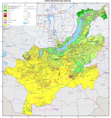
Forest resources and their use
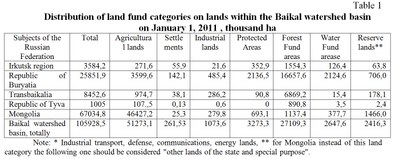
The Baikal basin is a truly enormous treasury of "green gold." As of January 1, 2011 the forest area is 32103.6 thousand hectares in the Russian part of the basin and 10354.3 thousand hectares in Mongolia. Total timber reserves in the Russian part of the basin are 2,795,800,000 m3, with a stock of the conifers 2.443.000.000 m3 (87.4 %). In Mongolia the total timber reserves is 1.373.100.000 m3.
The basic map shows the forests of nature conservation and other preservation patterns, as well as merchantable and other forests, suitable for commercial use, and reserved forests. It should be said that the division of forest lands into protected, merchantable and reserved is characteristic only of the Russian Federation. However, in the territory of Mongolia forests of special importance and in need of protection are distinguished, such as forest areas up to 100 hectares, forests on the slopes of the mountain areas of more than 30 degrees, etc.
Protected forests in Russia include forests subject to reclamation in order to maintain environmental, water protection, safety, sanitation, health and other useful features while using these forests providing compatibility with their intended purpose. Within the Baikal basin there is a high proportion of protected forests, due their ecosystemic, environment protection and water protection functions, as well as the important ecological role of montane forests. Merchantable forests are those which should be developed for the purposes of sustainable, maximum-efficiency rate production of high quality wood and other forest resources, as well as their conversion products ensuring the preservation of beneficial functions of forests. As far as the reserved forests are concerned, those are the forests not planned for logging for next twenty years. These forests are mostly located in the northern part of the region, in the permafrost zone, off-road area and are unattractive for development.
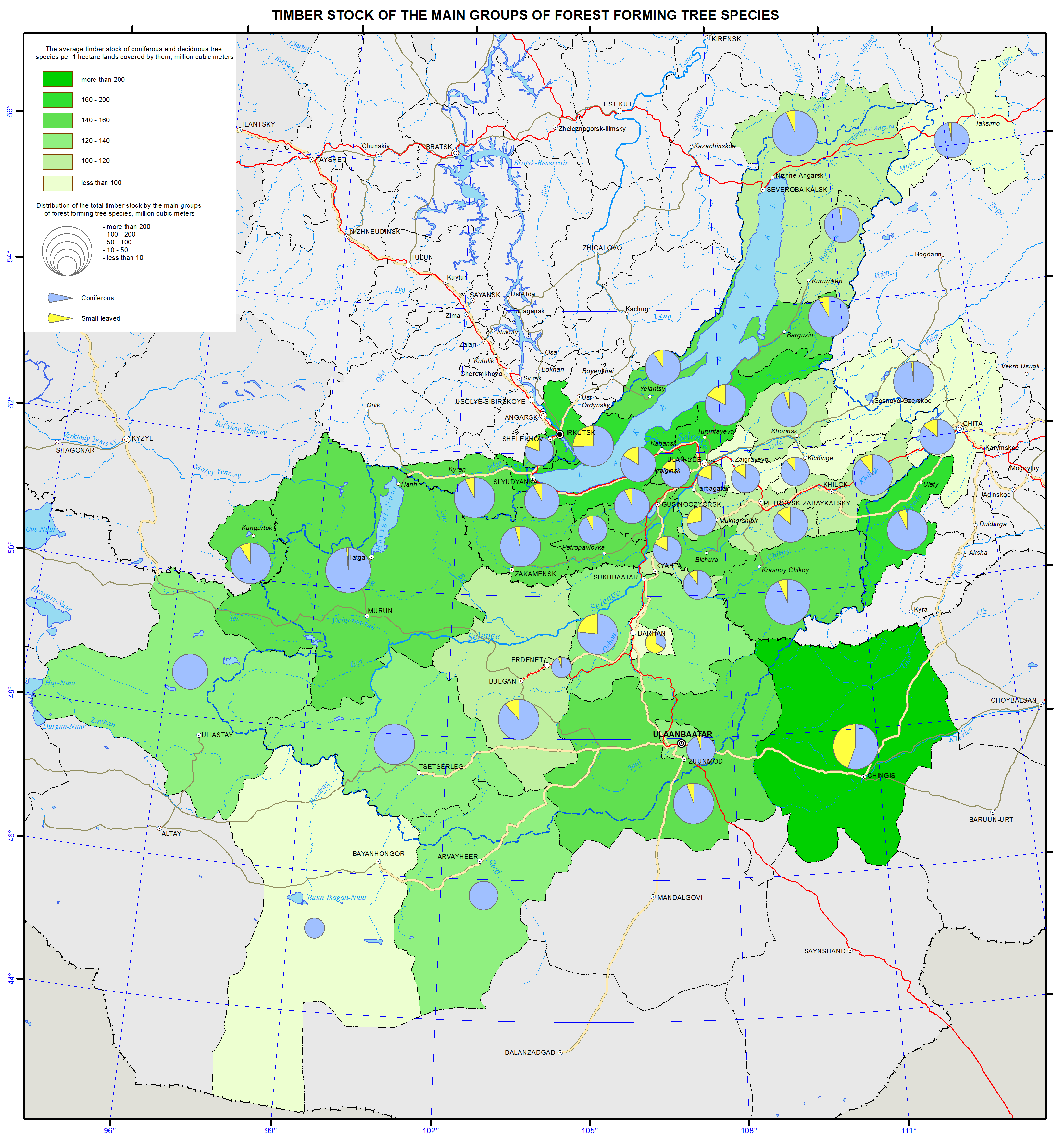
The insert map "Timber reserves by groups of the major forest forming species" shows the average reserves of softwood and hardwood forests (m3) per hectare of land covered by them. The average stand of timber per unit of the covered area is one of the indicators characterizing the productivity of forests, depending on growing conditions of stands, their species, and stands sparsity. The average stand of conifers and deciduous trees per hectare in the Russian part of the Baikal basin is 132.5 m3 (the global average is 100 m3/ha ), and it is fluctuating from 79-82 m3/ha (mostly in the steppe regions of Zabaikalsky krai, the Republic of Buryatia (Zaigraevsky, Chita districts) to 160 -170 m3/ha and up in the mid- and north areas (Uletovsky district of Transbaikalia, Kabansky and Severobaikalsky districts of the Republic of Buryatia, Irkutsky and Slyudyansky districts of Irkutsk oblast). Within the Mongolian part of the basin the average reserve of coniferous and deciduous tree stands is 126.6 m3 per one hectare with fluctuations in the aimaks from 81 to 205 m3 per ha. The highest average stand of timber per unit of forest area is characteristic of the northern mountainous areas of Mongolia.
Also this map shows the distribution of the total stand of timber by major groups of forest forming species (in million m3) with the method of cartodiagram. This index demonstrates forest-resource security area, which varies significantly in the districts of the Russian part of the basin and Mongolian aimaks (from 1.5 to 481 million m3). For correct depiction of the amount of total stand of timber within municipalities a conventional stepped scale for the circular cartodiagram was worked out, which enables to judge about the stands of timber for each group using the percentage between the major groups of forest forming species (coniferous, deciduous and shrubs).
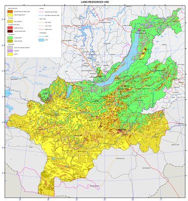
Forest use is determined by the activities that have priority development within the forest vegetation areas. Timber harvesting is most developed among all kinds of forest utilization in the Russian part of the Baikal basin regulated by allowable cutting rates. Forests are actively used for recreation, hunting activities, etc.
In the analysis of forest utilization the following trends for all forests of the Baikal basin are revealed in recent years. They are reduction of coniferous stands, mostly maturing and mature stands; replacement of coniferous species by deciduous ones; widespread illegal logging, reduction of forested area due to fires, forest damage by pests, deforestation, and insufficient reforestation.
]]>

