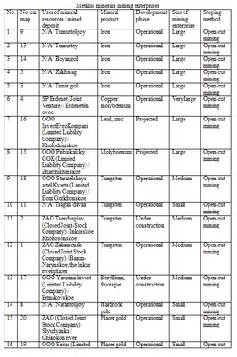
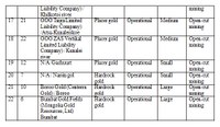
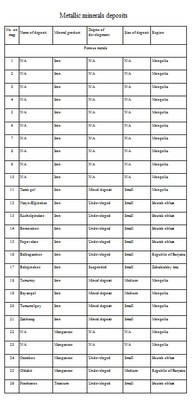
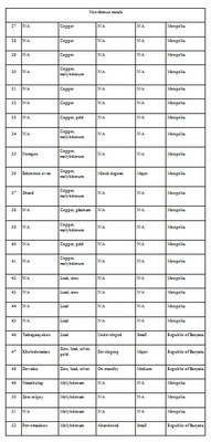
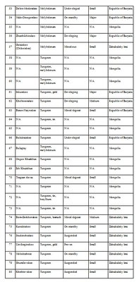
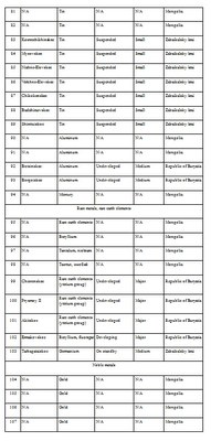
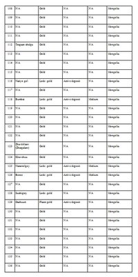
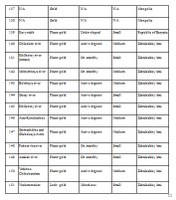
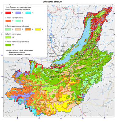
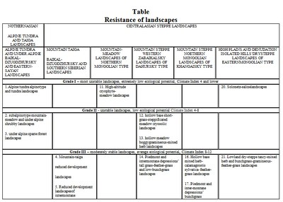
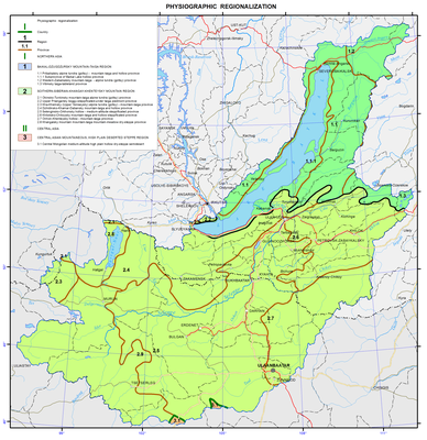
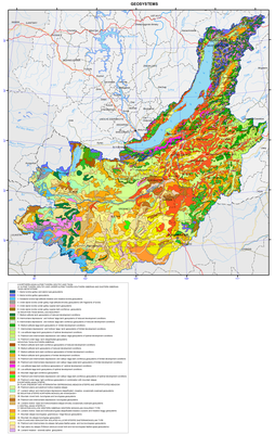
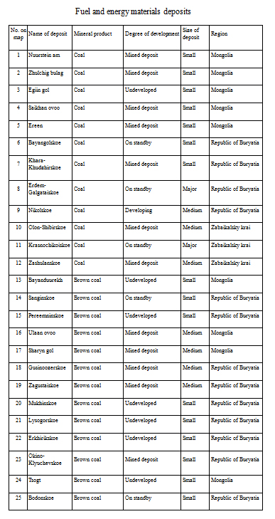
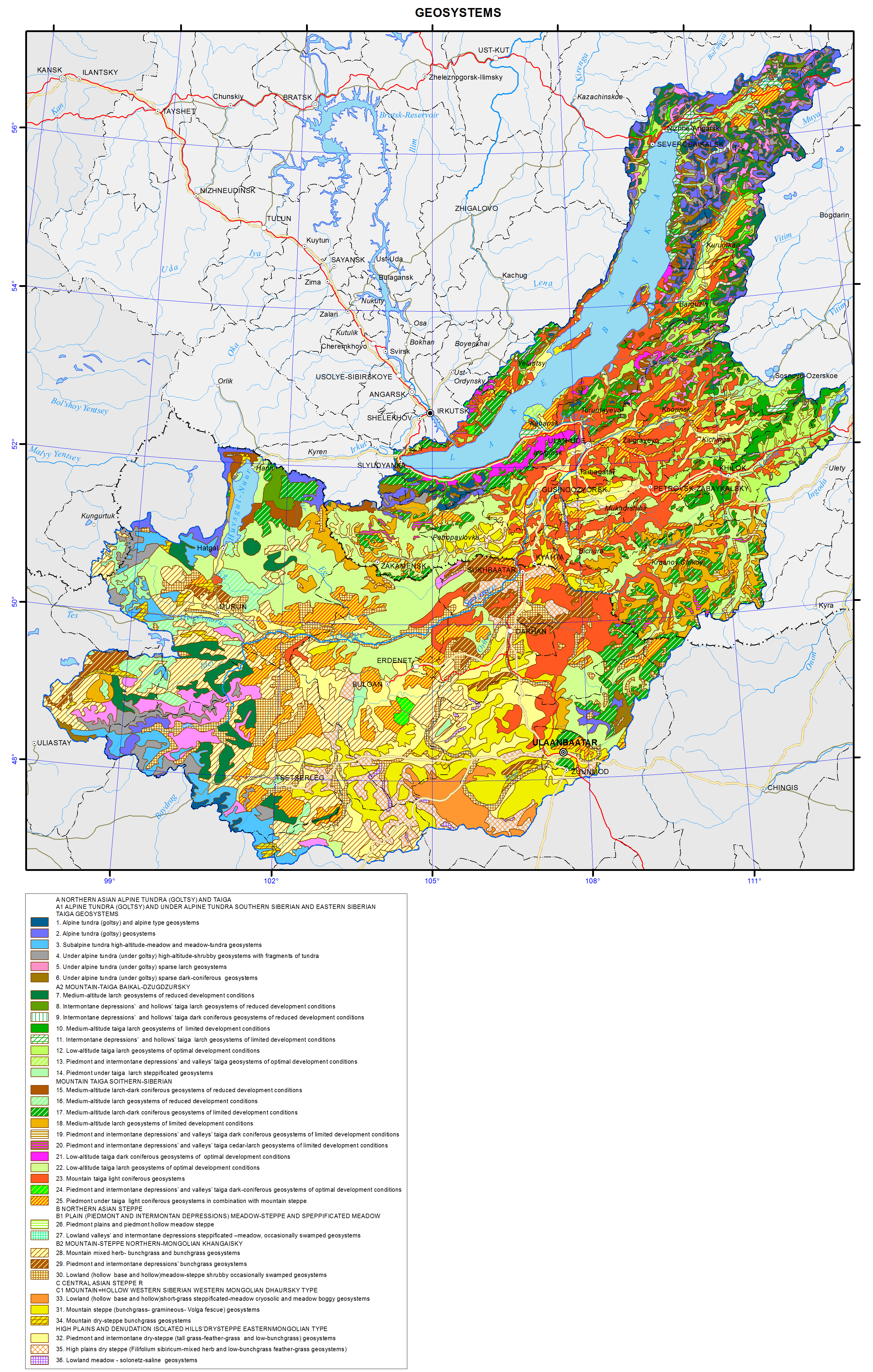
<?xml version="1.0" encoding="utf-8" ?>
<rdf:RDF xmlns:rdf="http://www.w3.org/1999/02/22-rdf-syntax-ns#" xmlns:dc="http://purl.org/dc/elements/1.1/" xmlns:syn="http://purl.org/rss/1.0/modules/syndication/" xmlns="http://purl.org/rss/1.0/">


<channel rdf:about="http://bic.iwlearn.org/en/search_rss">
  <title>English</title>
  <link>http://bic.iwlearn.org</link>

  <description>
    
            These are the search results for the query, showing results 211 to 225.
        
  </description>


  <image rdf:resource="http://bic.iwlearn.org/logo.png"/>

  <items>
    <rdf:Seq>
      
        <rdf:li rdf:resource="http://bic.iwlearn.org/en/atlas/atlas/49-recreational-resources-of-climate-map"/>
      
      
        <rdf:li rdf:resource="http://bic.iwlearn.org/en/atlas/atlas/48-mineral-waters-map/mineral-waters-map"/>
      
      
        <rdf:li rdf:resource="http://bic.iwlearn.org/en/atlas/atlas/48-mineral-waters-map"/>
      
      
        <rdf:li rdf:resource="http://bic.iwlearn.org/en/atlas/atlas/47-natural-resources-of-the-ground-waters-map/natural-resources-of-the-ground-waters-map"/>
      
      
        <rdf:li rdf:resource="http://bic.iwlearn.org/en/atlas/atlas/47-natural-resources-of-the-ground-waters-map"/>
      
      
        <rdf:li rdf:resource="http://bic.iwlearn.org/en/atlas/atlas/46-water-resources-and-consumptive-water-use-map/water-resources-and-consumptive-water-use-map"/>
      
      
        <rdf:li rdf:resource="http://bic.iwlearn.org/en/atlas/atlas/46-water-resources-and-consumptive-water-use-map"/>
      
      
        <rdf:li rdf:resource="http://bic.iwlearn.org/en/atlas/atlas/45-main-types-of-non-metallic-materials-map/main-types-of-non-metallic-materials-map"/>
      
      
        <rdf:li rdf:resource="http://bic.iwlearn.org/en/atlas/atlas/44-ferrous-nonferrous-rare-and-precious-metal-resources-and-their-extraction-map/ferrous-nonferrous-rare-and-precious-metal-resources-and-their-extraction-map"/>
      
      
        <rdf:li rdf:resource="http://bic.iwlearn.org/en/atlas/atlas/43-energy-resources-and-their-development-map/energy-resources-and-their-development-map"/>
      
      
        <rdf:li rdf:resource="http://bic.iwlearn.org/en/atlas/atlas/42-landscape-stability-map/landscape-stability-map"/>
      
      
        <rdf:li rdf:resource="http://bic.iwlearn.org/en/atlas/atlas/41-physiographic-regionalization-map/physiographic-regionalization-map"/>
      
      
        <rdf:li rdf:resource="http://bic.iwlearn.org/en/atlas/atlas/40-geosystems-map/geosystems-map"/>
      
      
        <rdf:li rdf:resource="http://bic.iwlearn.org/en/atlas/atlas/39-ichthyogeographical-complexes-map/copy_of_39-ichthyogeographical-complexes-map"/>
      
      
        <rdf:li rdf:resource="http://bic.iwlearn.org/en/atlas/atlas/38-taxonomic-diversity-map/taxonomic-diversity-map"/>
      
    </rdf:Seq>
  </items>

</channel>


  <item rdf:about="http://bic.iwlearn.org/en/atlas/atlas/49-recreational-resources-of-climate-map">
    <title>049. Recreational resources of climate map</title>
    <link>http://bic.iwlearn.org/en/atlas/atlas/49-recreational-resources-of-climate-map</link>
    <description></description>
    
    <dc:publisher>No publisher</dc:publisher>
    <dc:creator>Alexander Ayurzhanaev</dc:creator>
    <dc:rights></dc:rights>
    <dc:date>2014-10-08T07:25:00Z</dc:date>
    <dc:type>Folder</dc:type>
  </item>


  <item rdf:about="http://bic.iwlearn.org/en/atlas/atlas/48-mineral-waters-map/mineral-waters-map">
    <title>Mineral waters map</title>
    <link>http://bic.iwlearn.org/en/atlas/atlas/48-mineral-waters-map/mineral-waters-map</link>
    <description></description>
    <content:encoded xmlns:content="http://purl.org/rss/1.0/modules/content/"><![CDATA[<p><img class="image-inline" src="../../../resolveuid/c6afd68e36b64110bdddd43d637b238c/@@images/image/preview" /></p>
<p><a href="http://bic.iwlearn.org/en/atlas/photos/copy_of__48_Mineralwaters.png" class="internal-link">Open full size</a></p>
<p align="center"><strong>Mineral springs</strong></p>
<p align="center"><strong> </strong></p>
<p>The map is based on generalizing monographs, maps of mineral waters and field research data obtained by the authors.</p>
<p>The map depicts mineral springs, the water of which can be used for balneological purposes according to its physical and chemical properties. These characteristics include: water temperature (hot springs); radon content (cold radon springs), content of free carbon dioxide (carbonic cold springs), content of sulphate sulfur (cold hydrogen sulfide springs) and iron (ferrous cold springs).</p>
<p>This map can be used for the organization of sanatorium-and-spa construction, as well as for planning of underground thermal water use in thermal engineering.<b> </b></p>
<p align="center">References</p>
<p>Borisenko, I.M., Zamana, L. (1978). <i>Mineral water of Buryatia</i>. - Ulan-Ude: Buryat kn. izd-vo. - 163 p.</p>
<p>Map of the Republic of Tyva (tourism objects, objects of nature, arzhaans, photos).(2012). - M1:1000000, Kyzyl.</p>
<p>Lomonosov, I.S., Kustov, Yu.I., Pinneker, E.V. (1977). <i>Mineral water in Baikal region</i>. – Irkutsk: Vost. Sib . kn. izd-vo. - 224 p.</p>
<p><i>Mineral water of southern part of Eastern Siberia.</i> Vol.II. (1962) – M.-L.: Izd. AN USSR. - 199 p.</p>
<p>Pissarsky, B.I., Nambar, B, Ariyadagva, B. (2003). <i>Map of mineral waters in Mongolia</i>. 1:2500000, - Ulaanbaatar.</p>]]></content:encoded>
    <dc:publisher>No publisher</dc:publisher>
    <dc:creator>Alexander Ayurzhanaev</dc:creator>
    <dc:rights></dc:rights>
    <dc:date>2014-10-08T05:50:00Z</dc:date>
    <dc:type>Page</dc:type>
  </item>


  <item rdf:about="http://bic.iwlearn.org/en/atlas/atlas/48-mineral-waters-map">
    <title>048. Mineral waters map</title>
    <link>http://bic.iwlearn.org/en/atlas/atlas/48-mineral-waters-map</link>
    <description></description>
    
    <dc:publisher>No publisher</dc:publisher>
    <dc:creator>Alexander Ayurzhanaev</dc:creator>
    <dc:rights></dc:rights>
    <dc:date>2014-10-08T05:45:00Z</dc:date>
    <dc:type>Folder</dc:type>
  </item>


  <item rdf:about="http://bic.iwlearn.org/en/atlas/atlas/47-natural-resources-of-the-ground-waters-map/natural-resources-of-the-ground-waters-map">
    <title>Natural resources of the ground waters map</title>
    <link>http://bic.iwlearn.org/en/atlas/atlas/47-natural-resources-of-the-ground-waters-map/natural-resources-of-the-ground-waters-map</link>
    <description></description>
    <content:encoded xmlns:content="http://purl.org/rss/1.0/modules/content/"><![CDATA[<p><img class="image-inline" src="../../../resolveuid/91d7cbf115014934aa1883b1a2596bb2/@@images/image/preview" /></p>
<p><a href="http://bic.iwlearn.org/en/atlas/photos/copy_of__47_Naturalresourcesofthegroundwaters.png" class="internal-link">Open full size</a></p>
<p align="center"><strong>Natural groundwater resources</strong></p>
<p align="center"><strong> </strong></p>
<p>The map is based on the monograph by B.I. Pisarsky (1987) using medium-scale hydrogeological maps for Irkutsk oblast, the Republic of Buryatia and Tyva, Transbaikalia and Mongolia. The area principle of mapping of natural groundwater resources (in units of groundwater flow) was applied, as the complex hydrological and geochemical method of partitioning the hydrograph of the total stream flow was the principal one in the course of its comprehensive assessment. Mapping was carried out by the reference catchments located within the same aquifer system and characterized by the homogeneity of geological and hydrogeological conditions and sufficiently long series of runoff observations. For part of the territory where information was either not available or sparse, the mapping method was based on hydrological and hydrogeological analogy.</p>
<p>The color map is based on the energy principle. Cold colors correspond to low values of the rate of subsurface water flow, warm colors to the high values. Extremes of the spectrum of white correspond to the extreme values of the intensity of subsurface flow. Ranking of values of natural groundwater resources and class gradation are brought into compliance with that existing in this area [Natural Resources..., 1976]. A more fractional division of low classes is caused by the low values of rate of subsurface water flow in the territory of Mongolia, occupying a significant part of the Baikal basin.</p>
<p>Distribution of natural groundwater resources in the Baikal basin is extremely uneven; nevertheless it is generally subject to the vertical zonation and latitudinal zonality. Anomalous values of the rate of subsurface water flow are confined to the basins with complex hydrogeological conditions.<b> </b></p>
<p align="center">References</p>
<p><i>Natural groundwater resources in southern East Siberia</i>. (1976). - Novosibirsk: Nauka. - 127 p.</p>
<p>Pisarsky, B.I. (1987). <i>Laws of formation of subsurface drainage basin of Lake Baikal</i>. - Novosibirsk: Nauka,- 158 p.</p>]]></content:encoded>
    <dc:publisher>No publisher</dc:publisher>
    <dc:creator>Alexander Ayurzhanaev</dc:creator>
    <dc:rights></dc:rights>
    <dc:date>2014-10-08T03:35:00Z</dc:date>
    <dc:type>Page</dc:type>
  </item>


  <item rdf:about="http://bic.iwlearn.org/en/atlas/atlas/47-natural-resources-of-the-ground-waters-map">
    <title>047. Natural resources of the ground waters map</title>
    <link>http://bic.iwlearn.org/en/atlas/atlas/47-natural-resources-of-the-ground-waters-map</link>
    <description></description>
    
    <dc:publisher>No publisher</dc:publisher>
    <dc:creator>Alexander Ayurzhanaev</dc:creator>
    <dc:rights></dc:rights>
    <dc:date>2014-10-08T03:30:00Z</dc:date>
    <dc:type>Folder</dc:type>
  </item>


  <item rdf:about="http://bic.iwlearn.org/en/atlas/atlas/46-water-resources-and-consumptive-water-use-map/water-resources-and-consumptive-water-use-map">
    <title>Water resources and consumptive water use map</title>
    <link>http://bic.iwlearn.org/en/atlas/atlas/46-water-resources-and-consumptive-water-use-map/water-resources-and-consumptive-water-use-map</link>
    <description></description>
    <content:encoded xmlns:content="http://purl.org/rss/1.0/modules/content/"><![CDATA[<p><img class="image-inline" src="../../../resolveuid/86495cfb5da141959b6184ef5070c772/@@images/image/preview" /></p>
<p><a href="http://bic.iwlearn.org/en/atlas/photos/copy_of__46_Waterresourcesandconsumptivewateruse.png" class="internal-link">Open full size</a></p>
<p align="center"><strong>Water resources and water consumption</strong></p>
<p>The river network of the Baikal basin comprises about 10.4 thousand streams. The catchment area of Lake Baikal is asymmetrical; large river systems drain the south-eastern and north-eastern parts of the basin. The most significant river systems are the Selenga river and its right tributaries, namely, the Chikoy, Khilok, and Uda rivers, as well as the Barguzin and Upper Angara rivers. About 53% of river waters are formed in the territory of the Republic of Buryatia, 27% ​​- in the territory of Mongolia, 16% - in the territory of Zabaikalsky krai, and 4% - in Irkutsk oblast. Annually about 60 km<sup>3</sup>of water flow in and out of Lake Baikal with water streams and through the Angara river.</p>
<p>The origins of most rivers are located on slopes of mountain ranges at altitudes of 1200-1400 m. Therefore, in the upper reaches, and for many rivers along their entire length, they are of mountain character. Riverbeds with deep erosional incisions are rocky. Within the greater part of their valleys a floodplain is almost absent. Only large rivers in the middle and lower reaches have a character close to the plain one [Hydroclimate… , 2013].</p>
<p>The most ancient river systems drain the western slopes of the mountains surrounding Lake Baikal; they are the Sarma, Buguldeika, and Anga rivers. The class of such systems also includes basins of the largest Selenga and Barguzin rivers. The river systems of the south-eastern and northern macroslopes of Lake Baikal, namely, the Utulik, Tyya, Upper Angara, Turka, etc., are relatively young.</p>
<p>Methods of structural hydrography were used to compile a map of the rate of stream flow. Calculations of the river flow were made for the entire river network of the basin and were based on the close connection between the structure of the river network and its average rate of stream flow at any point of the system [Amosova, Ilyicheva, and Korytny, 2012]. Based on topographic maps, a graph of the river network was constructed, and then structural parameters for each point of the confluence of streams were calculated. Structural modules, representing the ratio of the water flow rate (Q, m<sup>3</sup>/s) to the structural measure at the given point, were determined. Data of reference materials on all hydrometeorological sections on the average long-term runoff from 105 gauges served as initial hydrological information [Surface water resources ..., 1972; Hydrological ..., 1977].</p>
<p>The rate of stream flow of the river systems is shown as an along-riverbed scale band (curve). This technique is usually called the method of localized diagrams, which is a method of cartographic representation of phenomena that have a continuous or linear (band) distribution. In the present case, the curves are referred to a linear element of the space, i.e. to a riverbed. The curves are drawn on both sides of the riverbed; they are proportional to the stream flow. The width of the curves varies along the length of a river and at the points of confluence with tributaries, depending on their rate of stream flow. Three gradations of the rate of stream flow are distinguished due to the large range of water flow rates (more than 500 m<sup>3</sup>/s, 50-500 m<sup>3</sup>/s, and 5-50 m<sup>3</sup>/s), which largely corresponds to the division of rivers according to their size. The mapping starts with the average long-term water flow rate of at least 5 m<sup>3</sup>/s, as values of lower rate of stream flow are difficult to represent [Korytny, 2001].</p>
<p>Within the boundaries of the administrative units, the volumes of local and general stream flow are calculated. Available water supply of the territory with the local stream flow is shown using five gradations. Mountain areas with the river systems of the northern and southern parts of the Baikal depression are characterized by the largest water supply. Administrative units of the Mongolian part of the Selenga river basin are generally poorly provided with local resources of river flow (less than 0.05 and 0.05-0.15 km<sup>3</sup> per year).</p>
<p>The structure of water consumption is displayed using pie charts, the diameter of which corresponds to the volume of water consumption, and the area of sectors corresponds to the water use for various purposes, expressed as a percentage. On the whole, for the Baikal basin water consumption amounted to 502.050 thousand m<sup>3</sup> in 2011, of which 56.440 thousand m<sup>3 </sup>were taken for drinking and household purposes, 389.170 thousand m<sup>3</sup> - for production, and 56.440 thousand m<sup>3</sup>– for agricultural purposes. The main share of the river waters is drawn from the rivers of the Selenga basin. The largest consumers in the basin are the cities of Ulan-Ude and Severobaikalsk.<b></b></p>
<p align="center">References</p>
<p>Amosova, I.Yu., Ilyicheva, E.A., and Korytny, L.M. (2012). <i>Structural-and-hydrographic patterns of the river network structure of the Baikal Natural Territory.</i> www.channel2012.ru. Tomsk.</p>
<p><i>Hydrological regime of the Selenga basin rivers and methods of its calculation.</i> (1977). Ed. by V.A. Semenov and B. Myagmarzhav. Leningrad: Gidrometeoizdat, 237 p.</p>
<p><i>Hydroclimate studies of the Baikal Natural Territory.</i> (2013). Ed. by L.M. Korytny.  Novosibirsk: Akademicheskoe izd-vo “GEO”, 186 p.</p>
<p>Korytny, L.M. (1972). <i>The basin concept in nature management.</i> Irkutsk: Izd-vo IG SB RAS, 2001, 163 p.</p>
<p><i>Surface water resources of the USSR.</i> Vol. 16, issue 3. Leningrad: Gidrometeoizdat, 595 p.</p>]]></content:encoded>
    <dc:publisher>No publisher</dc:publisher>
    <dc:creator>Alexander Ayurzhanaev</dc:creator>
    <dc:rights></dc:rights>
    <dc:date>2014-10-08T03:20:00Z</dc:date>
    <dc:type>Page</dc:type>
  </item>


  <item rdf:about="http://bic.iwlearn.org/en/atlas/atlas/46-water-resources-and-consumptive-water-use-map">
    <title>046. Water resources and consumptive water use map</title>
    <link>http://bic.iwlearn.org/en/atlas/atlas/46-water-resources-and-consumptive-water-use-map</link>
    <description></description>
    
    <dc:publisher>No publisher</dc:publisher>
    <dc:creator>Alexander Ayurzhanaev</dc:creator>
    <dc:rights></dc:rights>
    <dc:date>2014-10-08T03:15:00Z</dc:date>
    <dc:type>Folder</dc:type>
  </item>


  <item rdf:about="http://bic.iwlearn.org/en/atlas/atlas/45-main-types-of-non-metallic-materials-map/main-types-of-non-metallic-materials-map">
    <title>Main types of nonmetallic materials map</title>
    <link>http://bic.iwlearn.org/en/atlas/atlas/45-main-types-of-non-metallic-materials-map/main-types-of-non-metallic-materials-map</link>
    <description></description>
    <content:encoded xmlns:content="http://purl.org/rss/1.0/modules/content/"><![CDATA[<p><img class="image-inline" src="../../../resolveuid/e609421c005a4d33a8cad29965afb9ce/@@images/image/preview" /></p>
<p><a href="http://bic.iwlearn.org/en/atlas/photos/copy_of__45_Maintypesofnonmetallicmaterials.png" class="internal-link">Open full size</a></p>
<p><img class="image-inline" src="../../../../resolveuid/b1d7d06c2c2f41659de254b9f3dcf0e7/@@images/image/preview" /></p>
<p><a href="http://bic.iwlearn.org/en/photos/copy_of__45_Table_Legend_Maintypesofnonmetallicmaterials.png" class="internal-link">Open full size</a></p>
<p align="center"><strong>The main types of nonmetallic raw materials: resources and development</strong></p>
<p>Nonmetallic mineral resources of the region are of great industrial importance. Within the Baikal basin there are deposits of mining-chemical, thermo-chemical, and optical raw materials, construction materials, mineral fertilizers, ornamental and precious stones.</p>
<p>Deposits of <i>raw quartz </i>belong to strategic types of mineral resources. The region has a large raw materials base explored and prepared for industrial development: there are deposits of especially pure granular quartz (Chulbonskoe, Nadyozhnoe, Goudzhekitskoe, and others) and quartzites (Cheremshanskoe and Goloustenskoe). The vast majority of deposits are located in the territory of Buryatia; there are all prerequisites for creating a large complex of plants for deep processing of raw quartz for high-tech industries. In prospect, the republic can become the largest producer and exporter of polysilicon and total energy systems. Currently, there is a development project of the Chulbonskoe granular quartz deposit in the Severobaikalsky municipal district to get the end-product in the form of photovoltaic systems.</p>
<p>Quartzites of the mined Cheremshanskoe deposit are of exceptionally high raw materials quality meeting industrial requirements for the production of industrial silicon, silicon carbide and ferrosilicon; in recent years, research is carried out on the purest varieties to produce high-purity silicon for  helioenergetics and growing of single crystals of piezoelectric quartz. The deposit has been mined since 1992 by ZAO (Closed Joint Stock Company) “Cheremshansky quartsit” with an annual output of about 200 thousand tons and is a mineral resource base of ZAO (Closed Joint Stock Company) “Kremniy” of the OK (United Company) RUSAL, one of the most cutting edge silicon production facilities in Russia and the country's only producer of refined silicon .</p>
<p>Quartzites of the Goloustenskoe deposit can be used in metallurgy, and in the production of silica bricks. Sources of high-quality abrasive raw materials are microquartzites of two large deposits, located in the Olkhonsky municipal district on the eastern slope of the Baikal Range, namely, Srednekedrovoe and Zavorotninskoe. The latter was developed from 1975 till 1993 by “Baikalkvartssamotsvety”; currently, the deposits are on the governmental standby.</p>
<p>Considerable reserves of raw <i>fluorspar </i>were explored in the Baikal basin in the Republic of Buryatia. Currently, one deposit is mined here. It is the medium Egitinskoe deposit in the Eravninsky district; extracted ore is processed at the ore-dressing plant of the Zabaikalsky mining complex. The Naranskoe deposit in the Selenginsky district was prepared for operation and was mined for some time. The Kyakhtinskaya fluorspar factory operated near the settlement of Khoronkhoy from 1966; first it worked on local raw materials, and then on raw materials imported from Mongolia. Currently, the factory is out of operation.</p>
<p>The region possesses large reserves of chemically pure <i>limestone</i>s: in the Olkhonsky municipal district there is the Ust-Anginskoe deposit, and in the Zaigraevsky district there is the Bilyutinskoe deposit developed for the production of calcium carbide and the Tatarsky Klyuch for the paint and coatings industry. Dolomites of the Tarabukinskoe deposit are used as a raw material for glass and metallurgical production.</p>
<p>Deposits of <i>phosphate</i> raw materials are known in Cisbaikalia. They are the Sarminskoe phosphorite deposit in the Olkhon municipal district and the Slyudyanskoe apatite deposit in the Sludyansky municipal district; in northern Mongolia large reserves of formation phosphorites in the Khovsgol phosphorite basin were discovered and previously explored. The main deposits of the basin are located in the immediate vicinity of Lake Khovsgol, which is an obstacle to their development. The large Oshurkovskoe apatite deposit is prepared for exploitation near the city of Ulan-Ude. On the basis of the approved ready reserves the Zabaikalsky apatite plant was under construction; it was closed down at the building phase of an ore-dressing plant because of possible deterioration of the environmental situation in the Baikal basin. Currently, there is a project of the deposit’s development based on environmentally friendly technologies for the extraction and beneficiation of ores. Taking into account a sustained deficit of phosphate raw materials in the country, an increase of the raw materials base for the production of phosphate fertilizers is a matter of economic security of Russia. The planned standard of production of apatite concentrate is 500 thousand tons per annum. Breakstone will be produced as a by-product in the same amount of 500 thousand tons per annum.</p>
<p>Considering the <i>ceramic and fire-resisting raw materials</i>, deposits of Irkutsk oblast should be pointed out. They are the Naryn-Kuntinskoe microcline pegmatite deposit, developed earlier for the needs of the “Sibfarfor” factory, the Kharginskoe glass sands deposit, on the basis of which the Taltsy plant was established in 1784 producing a variety of glass products for 170 years, and the Asyamovskoe deposit of wollastonite, a relatively new kind of mineral products with a number of unique properties and a growing range of applications. In the south of Buryatia a sillimanite (high-alumina) shales deposit named Chyornaya Sopka is known; its ores have simple mineral composition and are easily dressed. On the basis of the deposit a non-waste production with the release of sillimanite and quartz as commercial products can be created. All the above mentioned deposits are currently on the governmental standby.<i> </i></p>
<p><i>Phlogopite mica</i> deposits in the south of Lake Baikal have been known since the second half of the 18<sup>th</sup> century. Its regular commercial production using a ramified system of underground (tunnels, mines) and open (open pits) mine openings began in 1924 with the development of the electrical engineering industry in the country and lasted until 1973. From four to seven thousand tons of high-quality raw materials were mined annually in the Sludyansky district.<i></i></p>
<p><i>Graphite </i>is represented in the region by two large deposits, namely, the Bezymyannoe (the Slyudyansky municipal district) and Boyarskoe (the Kabansky municipal district) deposits. Ores of the Bezymyannoe deposit are high quality and free-milling according to the manufacturer's tests, but the deposit is located in close proximity to Lake Baikal. The Boyarskoe deposit has the largest reserves. Economic efficiency of its development in compliance with all environmental requirements can be quite high despite low average graphite content in the ore, thanks to its favorable transportation and geographical location.</p>
<p>In the past, a considerable part of the Baikal basin experienced intense volcanic activity, the product of which is <i>pearlite</i> deposits, among which the largest ones are Mukhor-Talinskoe, Zakultinskoe, and Kholinskoe. Currently, this raw material is produced by OAO (Joint Stock Company) “Perlit” on the Mukhor-Talinskoe deposit with the production output amounting to 1-10 thousand m<sup>3</sup> of raw material per annum over the last three years. The Kholinskoe pearlite and zeolite deposit is located on the border of the Republic of Buryatia and Zabaikalsky krai; the mining OOO (Limited Liability Company) “Kholinskie tseolity” develops the deposit. Nowadays, the capacity of the company mining such a valuable kind of mineral product as zeolites is small and amounts to only about 0.8 thousand tons.</p>
<p>Within the region there are a number of deposits of <i>precious and ornamental stones</i>. In Zabaikalsky krai, ZAO (Closed Joint Stock Company) “Turmalkhan” develops a unique deposit of jewelry tourmaline, which is the only one in Russia to date. In the Republic of Buryatia, OOO (Limited Liability Company) “Kaskad” exploits the Khargantinskoe deposit with an annual production of 20 tons of raw jade; ZAO (Closed Joint Stock Company) “MS Holding” started to develop the Khamarkhudinskoe jade deposit, where 510 tons were produced in 2012.</p>
<p>To meet the needs of the construction industry the region possesses significant resources of <i>mineral construction materials</i>: numerous deposits of cement, brick, sand and gravel raw materials, building and facing stone are explored in the area. The raw materials base of the Angarsky cement plant is the large Slyudyanskoe deposit of cement marbles, being developed by the OOO (Limited Liability Company) “Karyer Pereval” with an annual output of about 900 thousand tons. The Tarakanovskoe deposit of cement limestone and Timlyuiskoe deposit of loam supply the Timlyuisky cement plant with raw materials. OOO (Limited Liability Company) “Timlyuitsement” produces 250-400 thousand tons of limestone and 20-35 thousand tons of loam annually.</p>
<p>Facing stone deposits are located on the western and south-eastern shores of Lake Baikal; they are Burovshchina and Novo-Burovshchinskoe deposits of pink marbles and Buguldeiskoe deposit of highly-ornamental statuary marble of various color shades: from snow-white to smoky-gray. Currently, stone is not produced on any of these deposits. Among building stone deposits AO (Joint Stock Company) RZhD exploits two: one of them is the medium Angasolskoe deposit in Irkutsk oblast and the other is the large Zhipkhegenskoe deposit in Zabaikalsky krai forming the raw materials base of the same-name crushed stone plants. Several deposits of building stone are situated in the coastal zone of Lake Baikal, namely, Baikalskoe, Ermolaevskoe, Dinamitnoe and others, rendering their development impossible.</p>
<p>The following deposits of brick and keramzite claysand loams were discovered: the Murinskoe and Khuzhirskoe deposits in Cisbaikalia and Irkaninskoe deposit in the Severobaikalsky municipal district, deposits of sand-gravel mix, including the Utulikskoe deposit of high-quality raw materials, the Pankovskoe deposit of building sands, and so on.</p>
<p>Among <i>other</i> mineral resources of the region, the Zangodinskoe and Kalinishenskoe deposits of mineral paints, Khayanskoe deposit of drilling clays, several deposits of raw materials for stone casting, as well as deposits of mineral salts (sodium sulfate) should be mentioned. All deposits of these raw materials are small in terms of reserves and are on the governmental standby.</p>
<p>In Mongolia small deposits of asbestos, gypsum, graphite, talcum, magnesite, bentonite, ornamental stones (nephrite, serpentinite, lapis lasuli, ophicalcite, chalcedony, etc.), raw quartz, and mineral salts are known within the Baikal basin. As for construction materials there are deposits of building sand, brick, keramzite and ceramic clays, sand-gravel mix, building stone, etc.</p>
<p>The map presents the main nonmetallic mineral raw materials deposits, depending on their size and type of mineral product, as well as mining companies using symbols. The size of the symbol designating a company depends on the average production output over the recent three to five years or on the planned capacity of the objects designed and under construction; gradation is presented in the summary table. The color of the symbol corresponds to the operational phase of an enterprise. The Khubsugulsky phosphorite basin is shown with an areal.</p>
<p>Map construction required the use of the materials of the Regional Funds of Geological Information, maps of mineral resources of the A.P. Karpinsky Russian Geological Research Institute; materials of State Reports “On the Condition of Lake Baikal and Measures of its Protection” for 2010–2012; “National Atlas of the Mongolian People's Republic” (1990), “Atlas of Mongolia” in the Mongolian language (2010), and “Atlas of Socioeconomic Development of Russia” (2009). Information on deposits according to the types of raw materials and on mining companies is presented in the summary table.</p>
<p><img class="image-inline" src="../../../../resolveuid/d284b6f61e4c44f8ad43d46a668322d3/@@images/image/preview" /></p>
<p><a href="http://bic.iwlearn.org/en/photos/45.jpg" class="internal-link">Open full size</a></p>
<p><img class="image-inline" src="../../../../resolveuid/98bbb5cc2eef41158328f7f0eeb57425/@@images/image/preview" /></p>
<p><a href="http://bic.iwlearn.org/en/photos/451.jpg" class="internal-link">Open full size</a></p>
<p><img class="image-inline" src="../../../../resolveuid/a62eb843c052454cb3739df217414e92/@@images/image/preview" /></p>
<p><a href="http://bic.iwlearn.org/en/photos/452.jpg" class="internal-link">Open full size</a></p>
<p><img class="image-inline" src="../../../../resolveuid/6a6a2fd6be0d47ea9f98156bdefaf7d7/@@images/image/preview" /></p>
<p><a href="http://bic.iwlearn.org/en/photos/453.jpg" class="internal-link">Open full size</a></p>
<p><img class="image-inline" src="../../../../resolveuid/ae9af4a5656a4070a90f7207e47a3c60/@@images/image/preview" /></p>
<p><a href="http://bic.iwlearn.org/en/photos/454.jpg" class="internal-link">Open full size</a></p>
<p><img class="image-inline" src="../../../../resolveuid/dd33f181df6e436c924598b054fbd494/@@images/image/preview" /></p>
<p><a href="http://bic.iwlearn.org/en/photos/455.jpg" class="internal-link">Open full size</a></p>
<p><img class="image-inline" src="../../../../resolveuid/17b13986651f47f7bbddb28738053f17/@@images/image/mini" /></p>
<p><a href="http://bic.iwlearn.org/en/photos/456.jpg" class="internal-link">Open full size</a></p>]]></content:encoded>
    <dc:publisher>No publisher</dc:publisher>
    <dc:creator>Alexander Ayurzhanaev</dc:creator>
    <dc:rights></dc:rights>
    <dc:date>2014-10-08T01:50:00Z</dc:date>
    <dc:type>Page</dc:type>
  </item>


  <item rdf:about="http://bic.iwlearn.org/en/atlas/atlas/44-ferrous-nonferrous-rare-and-precious-metal-resources-and-their-extraction-map/ferrous-nonferrous-rare-and-precious-metal-resources-and-their-extraction-map">
    <title>Ferrous, nonferrous, rare and precious metal resources and their extraction map</title>
    <link>http://bic.iwlearn.org/en/atlas/atlas/44-ferrous-nonferrous-rare-and-precious-metal-resources-and-their-extraction-map/ferrous-nonferrous-rare-and-precious-metal-resources-and-their-extraction-map</link>
    <description></description>
    <content:encoded xmlns:content="http://purl.org/rss/1.0/modules/content/"><![CDATA[<p><img class="image-inline" src="../../../resolveuid/c0893da58701459699e0f5004007f3b0/@@images/image/preview" /></p>
<p><a href="http://bic.iwlearn.org/en/atlas/photos/copy_of__44_Ferrousnonferrousrareandpreciousmetalresourcesandtheirextraction.png" class="internal-link">Open full size</a></p>
<p><img class="image-inline" src="../../../../resolveuid/086337cddf4549b08338fd489baddd69/@@images/image/preview" /></p>
<p><a href="http://bic.iwlearn.org/en/photos/copy_of__44_Table.png" class="internal-link">Open full size</a></p>
<p align="center"><strong>Resources of ferrous, nonferrous and rare metals and their mining</strong></p>
<p>Geological exploration exposed over 150 deposits of metallic minerals within the Baikal basin.<b> </b></p>
<p><b>Ferrous metals</b> are represented by a number of iron ore deposits of different genetic types, including two small magnetite deposits, namely, Balbagarskoe in the territory of the Khorinsky municipal district of the Republic of Buryatia and Baleginskoe in the Petrovsk-Zabaikalsky district of Zabaikalsky krai. In the 18<sup>th</sup>-19<sup>th</sup> centuries the Baleginsky mine supplied iron ore to the Petrovsky plant to procure iron and steel for the mines of the Nerchinsky district. In the Olkhonsky municipal district of Irkutsk oblast small iron ore deposits are known; they are mainly represented by brown iron ore deposits (Borsoiskoe, Kuchelginskoe, etc.). In the first half of the 18<sup>th</sup> century, ore from these deposits was used for the needs of the Anginsky (Laninsky) ironworks. The most promising iron ore deposits of Mongolia are the skarn type deposits such as Tumurtolgoy, Bayangol, and Tumurtey, forming the Bayangol iron ore zone in the north of the country. Currently, iron ore deposits in the region are developed only in the territory of Mongolia: small scale extraction of iron ore is underway on the Zakhtsag and Tamir gol deposits; over the recent years, the production on the deposits of the Bayangolskaya iron ore zone amounted to more than five million tons; primary processing is performed at the cleaning plants near the deposits; iron-ore concentrate is exported to China.</p>
<p>The Oldakit manganese deposit, medium in terms of reserves, is located in the Severobaikalsky municipal district less than 30 km from the Baikal-Amur Mainline. Given the fact that Russia is currently experiencing shortage of this raw material, the deposit may be of some interest. Moreover, several small deposits of manganese are known within the boundaries of the Baikal basin, including the Ozerskoe deposit (Olkhonsky district) developed in the 19<sup>th</sup> century for the needs of the Nikolaevsky ironworks.<b></b></p>
<p><b>Nonferrous metals</b>. Almost all reserves and resources of copper ores of the region are concentrated in complex copper-molybdenum and molybdenum-tungsten deposits of Mongolia, located within the Selenginsky volcanoplutonic belt. From 1978 to present a large deposit Erdenetiyn ovoo has been developed; on its basis a joint Soviet-Mongolian venture, the Erdenet Mining Company was established. The plant is engaged in open-pit mining and primary processing of copper-molybdenum ores and is one of the world leaders in the production of copper concentrate. Currently, the production output amounted to more than 25 million tons of ore, while the production of copper concentrate is about 350 thousand tons. In a globalizing world economy, the company faces the challenge of marketability of its products, which necessitates the construction of a copper-smelting plant. At present, the Erdenet Mining Company comprises a pilot plant for the production of pure cathode copper from off-balance and storage ore dump piles of KOO (Limited Liability Company) “Erdmin”, which is a joint venture of Erdenet Mining Company and the American company RCM.</p>
<p>Within the Baikal basin, the largest Kholodninskoe deposit of lead-zinc sulfide ores is explored and prepared for industrial development; its reserves amount to 11.2% of Russia’s total lead reserves and 34.1% of Russia’s total zinc reserves. Based on the economic indicators of development, the deposit is on par with the best world analogues. According to the feasibility study of final mining parameters, the annual production of the underground mine at the deposit should amount to three million tons of ore, 504 thousand tons of zinc concentrate, and 60.3 thousand tons of lead concentrate. In order to ensure environmental safety of production, provision is made for a circulating water supply system, transportation of wastes of the ore-dressing plant outside the catchment area of Lake Baikal using pipelines, and a number of other environmental measures. However, due to the fact that the deposit is located in the Central Ecological Zone of the Baikal Natural Territory (BNT), where mining activity is banned, the production license, owned by the KOO (Limited Liability Company) “InvestEuroCompany” was suspended until 2015. Among other objects of polymetallic raw materials in the region, the medium Davatkinskoe deposit, discovered and assessed in the Khorinsky municipal district of the Republic of Buryatia, should be pointed out.</p>
<p>In Buryatia there are two large deposits of molybdenum ores, namely, Zharchikhinskoe and Malo-Oinogorskoe, and small Pervomaiskoe (abandoned) and Dolon-Modonskoe (undeveloped) deposits. There is a project of the construction of the Pribaikalsky mining and processing plant on the basis of the Zharchikhinskoe deposit, located 40 km to the south of Ulan-Ude in close proximity to the highway and railway, with the molybdenum content in the ore of more than 0.1% and high technological and technical-economic indicators. Its effective development is possible, provided that all necessary environmental requirements are observed.</p>
<p>Tungsten in the region belongs to widespread elements. In the territory of the Zakamensky municipal district there is the Inkurskoe deposit of the stockwork geological-industrial type, which is comparable to the largest similar deposits of the world in terms of its reserves and tungsten content. The Kholtosonskoe deposit, located to the west of the Inkurskoe one, is the largest deposit of the vein type in Russia, and is considered to be unique not only in Russia but also in the world as to its characteristics. The Dzhidinsky tungsten-molybdenum mill operated from 1934 to 1996 on the basis of these two deposits as well as the Pervomaiskoe molybdenum deposit. After the closure of the mill, the tailings pond remained over the area of more than ​​one km<sup>2</sup>, forming the man-made Barun-Narynskoe deposit, the development of which has been started by OAO (Open Joint Stock Company) “Zakamensk” since 2010. A reclamation plant recycling the mill’s waste was built 1.5 km from the town of Zakamensk; the concentrate production amounts to about 300 tons per annum. ZAO (Closed Joint Stock Company) “Tverdosplav” is engaged in the construction of mining sites at the Inkurskoe and Kholtosonskoe deposits. It is planned to build a modern ore-dressing plant and a hydrometallurgical workshop for the processing of tungsten concentrates to produce commercial refined tungsten compounds. In the Petrovsk-Zabaikalsky municipal district of Zabaikalsky krai the prospectors' artel “Kvarts” mines the medium Bom-Gorkhonskoe tungsten deposit by the underground mining method. In recent years, the concentrate production amounted to around 600 tons. The remaining tungsten deposits within the territory of the Russian part of the Baikal basin are temporarily abandoned or are on the governmental standby.</p>
<p>A number of tungsten deposits are known in Mongolia. A small tungsten refinery plant was built on the Tsagaan davaa deposit; the concentrate production amounts to about 40 tons per annum; the final production is exported to the United States and China.</p>
<p>Tin deposits located in the Krasnochikoysky district are small in terms of reserves and are currently mothballed.</p>
<p>In the Dzhidinsky district of Buryatia the medium Borgoiskoe (Al2O3 – 19.8% on average) and Botsinskoe (21.44%) deposits of nepheline-bearing rocks are prospectively explored; currently they remain undeveloped.<b></b></p>
<p><b>Rare metals.</b> In the Kizhinginsky municipal district of the Republic of Buryatia there is the Ermakovskoe deposit of beryllium ores containing 80% of the total beryllium reserves of Russia and unique as to the grade of ore. From 1978 the deposit was developed by the Zabaikalsky mining and processing plant; in 1990 the enterprise was mothballed. Beryllium is a strategic metal essential for the development of nuclear, aerospace, and aviation industry, and instrument engineering; it is used in the manufacture of telecommunications equipment. Currently, Russia’s demand of this metal is met through imports. Whereas it is necessary to restore the raw material and production independence of the country in beryllium, it is expected to resume the production of ore on the deposit, and create production on primary processing of ore, as well as hydrometallurgical production, the end product of which – beryllium hydroxide – will be delivered to the Ulbinsky metallurgical plant in Kazakhstan for processing and producing beryllium alloying compositions and metal. The work to create the beryllium production is included in the Federal Target Program on rare metals of paramount importance.</p>
<p>In the Severobaikalsky municipal district within the Central Ecological Zone of the BNT, three subsoil plots of the Federal importance with large prognostic resources of rare earth elements of the yttrium group are on the governmental standby. They are the Chestenskoe, Akitskoe and Pryamoy-II deposits.<b></b></p>
<p><b>Noble metals. </b>Within the Russian part of the Baikal basin there are no lode gold deposits (except the mined-out Voskresenskoe deposit in the Krasnochikoysky municipal district). Placer gold deposits are small or medium and are grouped into the gold-placer regions, namely: Dzhidinsky, Namaminsky, Yambuy-Tolutaisky, Chikoysky, and Baldzhikansky. In the Republic of Buryatia within the territory under consideration gold practically has not been produced over the recent three years (economically advantageous deposits are mined-out, and exploration and appraisal works require substantial expenditures); in the Krasnochikoysky district of the ​​Zabaikalsky krai, four prospectors' artels produce 300-400 kg of gold annually using the open-pit hydromechanical method.</p>
<p>Gold is the second most significant mineral resource of Mongolia after copper. The industrial mining of gold ores in the country was launched in the early 20<sup>th</sup> century by the Russian-Mongolian joint-stock company “Mongolor” in the Iro-Gol river basin, in the Khovsgol region and in the Boroo area. Primary deposits are usually of the vein type, more rarely – mineralized zones. The most significant primary deposits in terms of reserves include the Boroo deposit in the Boroo-Zuunmod region and the Bumbat deposit in the Zaamarsky gold field. The metal content in individual layers reaches 10 g/t. The deposits are developed by Canadians with the annual production of five and 1.5 tons of metal, respectively. Moreover, gold is currently mined on the Narantolgoy and Nariyn gol deposits.</p>
<p>Among the placers small and medium ones predominate, and only single ones are large placers in terms of reserves. Most placers are shallow single-layer, rarely double-layer; in rare cases deep placers occur. Dredging and separate production techniques are applied at the placer deposits. After mining by large companies, the remaining gold is mined by individual prospectors, whose number exceeded 10 thousand people according to the official data alone. In river valleys, where mining is possible, huge settlements are formed. As a result, in recent years the country faced an intensive shallowing and pollution of rivers, shrinking of grazing lands for cattle, and a process of desertification of the southern territory, and drinking water shortages for population occur. This is largely due to huge volumes of gold mining in the river valleys, illegal use of mercury and cyanides, and almost total lack of reclamation.</p>
<p>The map symbols show metallic mineral deposits depending on their size and type of commercial minerals. Mining companies are also shown with symbols. The size of a symbol corresponds to the production output. The group of large companies include ferrous, nonferrous and rare metals producing enterprises with production ranging from 1 to 10 million tons of ore per annum, the group of medium ones comprises the production output of 0.1-1 million tons per annum,</p>
<p><img class="image-inline" src="../../../../resolveuid/b5bd74556d5045bcac18238e545cd3c4/@@images/image/preview" /></p>
<p><a href="http://bic.iwlearn.org/en/photos/44.jpg" class="internal-link">Open full size</a></p>
<p><img src="http://bic.iwlearn.org/en/photos/441.jpg/@@images/9854ac0a-f6fc-46c7-b910-b40a35514466.jpeg" alt="" class="image-inline" title="" /></p>
<p><a href="http://bic.iwlearn.org/en/photos/441.jpg" class="internal-link">Open full size</a></p>
<p>and small ones produce less than 0.1 million tons per annum. The Erdenet Mining Company is highlighted as a very large enterprise with an annual production of more than 20 million tons. The following gradation is accepted for gold mining: large companies are gold mines with the production of more than one ton per annum, medium companies are those producing 0.1-1 ton, and small ones are those with less than 0.1 tons produced. The color of the symbol corresponds to the exploitation phase of an enterprise: operating or projected and under construction; additional outline corresponds to the underground mining method. Gold-placer regions of the given territory are depicted by areals.</p>
<p>Table 1</p>
<p><img class="image-inline" src="../../../../resolveuid/f4a37e81d4d7431fbf95f7265a1b458e/@@images/image/preview" /></p>
<p><a href="http://bic.iwlearn.org/en/photos/442.jpg" class="internal-link">Open full size</a></p>
<p><img class="image-inline" src="../../../../resolveuid/1441b8be04934550bc0ebb4c83b9c44e/@@images/image/preview" /></p>
<p><a href="http://bic.iwlearn.org/en/photos/443.jpg" class="internal-link">Open full size</a></p>
<p><img class="image-inline" src="../../../../resolveuid/98c96c25632e4b9dba75b2fc82411706/@@images/image/preview" /></p>
<p><a href="http://bic.iwlearn.org/en/photos/444.jpg" class="internal-link">Open full size</a></p>
<p><img class="image-inline" src="../../../../resolveuid/1daaaef9f0114fa981b1592254b6aace/@@images/image/preview" /></p>
<p><a href="http://bic.iwlearn.org/en/photos/445.jpg" class="internal-link">Open full size</a></p>
<p><img class="image-inline" src="../../../../resolveuid/447e28e1422745858950a3147aee5e36/@@images/image/preview" /></p>
<p><a href="http://bic.iwlearn.org/en/photos/446.jpg" class="internal-link">Open full size</a></p>
<p><img class="image-inline" src="../../../../resolveuid/27ce7f6bf2034632ac0fd4ae1948ce81/@@images/image/mini" /></p>
<p><a href="http://bic.iwlearn.org/en/photos/447.jpg" class="internal-link">Open full size</a></p>]]></content:encoded>
    <dc:publisher>No publisher</dc:publisher>
    <dc:creator>Alexander Ayurzhanaev</dc:creator>
    <dc:rights></dc:rights>
    <dc:date>2014-10-08T01:20:00Z</dc:date>
    <dc:type>Page</dc:type>
  </item>


  <item rdf:about="http://bic.iwlearn.org/en/atlas/atlas/43-energy-resources-and-their-development-map/energy-resources-and-their-development-map">
    <title>Energy resources and their development map</title>
    <link>http://bic.iwlearn.org/en/atlas/atlas/43-energy-resources-and-their-development-map/energy-resources-and-their-development-map</link>
    <description></description>
    <content:encoded xmlns:content="http://purl.org/rss/1.0/modules/content/"><![CDATA[<p><img class="image-inline" src="../../../resolveuid/50171d236c784a0294d0db6b59dcfef5/@@images/image/preview" /></p>
<p><a href="http://bic.iwlearn.org/en/atlas/photos/copy_of__43_Energyresourcesandtheirdevelopment.png" class="internal-link">Open full size</a></p>
<p><img class="image-inline" src="../../../../resolveuid/b5f9ed0e07694b01987111cd68ecb502/@@images/image/preview" /></p>
<p><a href="http://bic.iwlearn.org/en/photos/copy_of__43_Table.png" class="internal-link">Open full size</a></p>
<p align="center"><strong>Fuel and energy resources and their development</strong></p>
<p>Fuel and energy resources of the Baikal basin are represented by deposits of solid fossil fuels (black and brown coals of different ranks), oil shales and uranium.<i></i></p>
<p><i>Coal deposits</i> are confined to the Upper-Mesozoic depressions of the Transbaikalian type, the most significant of which are the Tugnuiskaya, Gusinoozerskaya, Udinskaya, Chikoiskaya and others. The main reserves of black coals within the territory under consideration are concentrated in the Erdem-Galgataiskoe, Krasnochikoyskoe, Nikolskoe, Olon-Shibirskoe, and Zashulanskoe deposits, while the reserves of brown coals are localized in the Gusinoozerskoe, Zagustaiskoe, Taseiskoe, Sharyngol, and Ulaan-Ovoo deposits. The largest deposits are located in economically developed regions with an extended infrastructure, including the presence of traffic arteries in the form of railways and auto-roads. Out of 33 coal deposits, located within the territory of the Baikal basin, sixteen are currently under development.</p>
<p>To date the largest coal producer not only in this area, but in the entire East Siberia and the Far East is the Tugnuisky open-pit coal mine, which mines the Olon-Shibirskoe deposit (97% of the reserves occur within the Petrovsk-Zabaikalsky municipal district of Zabaikalsky krai, and 3% are deposited in the Mukhorshibirsky district of the Republic of Buryatia). Due to the introduction of the cutting-egde high-efficiency equipment produced by the world-renowned manufacturers, coal extraction here more than doubled in three years reaching about 13 million tons in 2012.A coal-preparation plant equipped with unique technologies was built in order to increase marketability of the produced coal. Currently, the capacity of this plant has reached nine million tons. Coal is mainly exported to Japan, Korea, China and other APAC countries.</p>
<p>The coal industry of Buryatia experienced a significant decline after closing in the early 1990s of the major coal producers of the time such as the Kholboldzhinsky open-pit mine and the Gusinoozerskaya mine (Selenginsky district). Currently, the OAO (Open Joint Stock Company) “Ugolnaya kompaniya Bain-Zurkhe” holds licenses for the Bain-Zurkhe and Kholboldzhinsky sites of the Gusinoozerskoe deposit. This company has resumed the coal feed from the deposit to the Gusinoozerskaya state district power plant. A radically new development technology – a highwall mining complex is applied. There is a gradual growth in coal production (932 thousand tons in 2012).</p>
<p>Over the recent years, the OOO (Limited Liability Company) “Ugolny razrez” mining the Okino-Klyuchevskoe brown coal deposit in the Bichursky municipal district of the Republic of Buryatia has expanded its production capacities. It is expected to increase the capacity of this enterprise to five million tons per annum and continue the construction of the railway spur to the Khoronkhoy station for coal conveying to the Gusinoozerskaya state district power plant. Besides, in order to provide the thermal energy facilities of the Republic of Buryatia with the locally produced coal, a construction of a large Nikolsky open-pit mine along with a coal-preparation plant on the basis of the balance reserves of the same-name coal deposit is planned. In the Selenginsky municipal district the OOO (Limited Liability Company) ”Buryatugol” currently develops the Zagustaiskoe deposit. It produces more than 200 thousand tons of brown coal per annum.</p>
<p>The remaining coal producers of Zabaikalsky krai and the Republic of Buryatia within the territory of the Baikal basin mine small volumes (10-50 thousand tons per annum), mainly for housing and public utility sector needs. They are the Daban-Gorkhonsky, Khara-Khuzhirsky, Zashulansky, and Burtuisky open-pit mines. An exception is the OOO (Limited Liability Company) “Razrez Tigninsky” developing the Tarbagataisky deposit in the Petrovsk-Zabaikalsky district. In 2012 it produced 260 thousand tons of brown coal significantly exceeding the level of 2010-2011. All coal is extracted by open-cut mining.</p>
<p class="a">Mongolia's oldest coal producer is the “Nalaikha” mine where small scale extraction was launched in 1912. After the reconstruction in the 1950s the capacity of the mine was brought up to 600-800 thousand tons of brown coal per annum. The mine is the economic mainstay of the town of Nalaikh and was originally the only source of fuel for thermal power plants under construction in Ulaanbaatar. After the official mine shutdown due to the impossibility of its safe operation the former professional miners became engaged in artisanal mining on the facility.</p>
<p>The Sharyngol brown coal deposit was discovered by Soviet geologists in the 1930s, but the development of the deposit began only in 1961, after additional exploration. In the 1980s, the open pit capacity reached the maximum values ​​of 2.5 million tons per annum. Currently, the company is privatized; in 2010 the production was about one million tons and open-cut mining is used.</p>
<p>In the Selenge aimak, the Ulaan-Ovoo high-energy brown coal deposit is currently developed. At the moment the Canadian company “Prophessy Coal” holds the development license of this deposit. Coal mining began in 2010.</p>
<p>Small scale coal mining is underway on Zhulchig bulag, Nuurestein am (Khuvsgel aimak), Saikhan ovoo and Ereen (Bulgan aimak) deposits.</p>
<p>Nowadays two small deposits of <i>uranium raw material</i> (Slantsevoe in the Dzhidinsky municipal district and Zhuravlinoe in the Mukhorshibirsky municipal district of the Republic of Buryatia; both deposits belong to the Selenginsky uranium ore region; a preliminary exploration was conducted on the deposits), and two medium ones, namely, Buyanovskoe in the Eravninsky district of Buryatia (Eravninsky uranium ore region; the deposit is on government standby) and Gornoe in the Krasnochikoysky municipal district of Zabaikalsky krai (Chikoysky uranium ore region) are known within the boundaries of the Baikal basin. The latter deposit is prepared for industrial development to produce natural uranium concentrate. It is planned to construct an underground mine and a heap leach pad for processing mined uranium ore.</p>
<p>Besides solid fuel the territory of the Baikal basin, was recognized as promising for the discovery of commercial deposits of <i>raw hydrocarbons</i>, especially natural gas within the Selenginskaya and Ust-Barguzinskaya rift troughs. According to the results of the prospecting and evaluation works carried out in the Ust-Selenginskaya depression in 1955, 1962, and in the 1990s, its prospective hydrocarbon resources were estimated at 364 million tons of oil, and 520 billion m<sup>3 </sup>of natural gas (C3 category). Prospect assessment works on the Barguzinskaya depression are in progress.</p>
<p>Due to their small scale and low resin content (8-10%) oil shale deposits are of no commercial interest.</p>
<p>The map “Fuel and energy resources and their development” displays deposits of solid fossil fuels (black coal, brown coal and uranium) designated by various symbols. The symbol size is determined by the size of a deposit. Mining companies are also shown using symbols. The symbol size depends on the average production output over the last 3-5 years (for operating enterprises), or on the design capacity (for companies projected or under construction). The following ranking of enterprises was adopted: large ones with the production of over one million tons, medium ones – from 100 thousand tons to one million tons, and small ones – less than 100 thousand tons per annum for coal mining enterprises; the projected uranium mining company “Gornoe” is a small one with the production of less than one thousand tons of uranium per annum. Circled symbols show the underground mining method, while color indicates the operational stage of an enterprise (operating or projected and constructed). Areals depict the Upper-Mesozoic depressions - potential and actual coal-bearing regions and prospective oil and gas areas.</p>
<p><img class="image-inline" src="../../../../resolveuid/686dfb9933e34ef7a69f3c0727b357aa/@@images/image/preview" /></p>
<p><a href="http://bic.iwlearn.org/en/photos/43.jpg" class="internal-link">Open full size</a></p>
<p><img class="image-inline" src="../../../../resolveuid/f4063718ac984d178283097fb461c83c/@@images/image/mini" /></p>
<p><a href="http://bic.iwlearn.org/en/photos/432.jpg" class="internal-link">Open full size</a></p>]]></content:encoded>
    <dc:publisher>No publisher</dc:publisher>
    <dc:creator>Alexander Ayurzhanaev</dc:creator>
    <dc:rights></dc:rights>
    <dc:date>2014-10-08T01:15:00Z</dc:date>
    <dc:type>Page</dc:type>
  </item>


  <item rdf:about="http://bic.iwlearn.org/en/atlas/atlas/42-landscape-stability-map/landscape-stability-map">
    <title>Landscape stability map</title>
    <link>http://bic.iwlearn.org/en/atlas/atlas/42-landscape-stability-map/landscape-stability-map</link>
    <description></description>
    <content:encoded xmlns:content="http://purl.org/rss/1.0/modules/content/"><![CDATA[<p><img class="image-inline" src="../../../../resolveuid/def380b90f9b43e4b12b647035d988e2/@@images/image/preview" /></p>
<p><a href="http://bic.iwlearn.org/en/photos/copy2_of__42_LandscapeStability.png" class="internal-link">Open full size</a></p>
<p><img class="image-inline" src="../../../../resolveuid/145d45f9d03741aa8547a78a340e3803/@@images/image/preview" /></p>
<p><img class="image-inline" src="../../../../resolveuid/e1c273139cad4e6d90a1922fc5d06091/@@images/image/preview" /></p>
<p align="center"><strong>Landscapes stability </strong></p>
<p align="center"><strong> </strong></p>
<p>Landscape stability is one of the most important parameters determining the state of the environment and changes occurring in it under the influence of natural and anthropogenic factors. The nature of landscape changes depends on the location in the geographical environment, their properties, and type and extent of the anthropogenic impact. Of particular importance is the estimation of landscapes stability of the Baikal basin, which is an environmentally critical area.</p>
<p>Landscape stability is a property of a geosystem to maintain its structure and the mode of functioning under changing conditions of its environment [Protection of landscapes..., 1982]. An assessment and mapping of landscapes stability are made according to the complex of natural and anthropogenic factors of influence. The natural factor is mainly determined by the influence of climate (indicators of heat-moisture supply) and the properties of lithological-and-geomorphological basis. The anthropogenic influencing factor is associated with the background nature management, which is based on spatially extensive use of natural resources, and lands, closely related to the zonal-belt features of natural landscapes. The background types of nature management in the study area include agriculture, mainly in steppe landscapes, forestry in taiga landscapes, as well as recreation.</p>
<p>Stability is considered in relation to landscapes of two levels: regional (geoms) and topological (groups of facies). A landscape map, compiled by the authors on the basis of landscape maps of the territory under consideration [Landscapes..., 1977; Landscapes..., 1990], was used for its mapping.</p>
<p>Stability of landscapes of the regional level – geoms – is determined based on the level of natural ecological potential of a landscape (EPL), the main indicator of which is the index of biological effectiveness of climate (TK) according to N.N. Ivanov [Ecological..., 2007, Ecological..., 2007]. Characterization and comparative assessment of this indicator is based on the ratio of heat and moisture, on which the biological productivity of a landscape and ecological capacity primarily depend. At the same time, the influence of latitudinal and altitudinal zonality on their distribution is traced. A single and continuous process of moisture and heat exchange not only forms the spatial differentiation and a type of a landscape, but also determines its stability. Landscapes with high values of TK and EPL are the most stable, while low values ​​of these parameters characterize unstable landscapes.</p>
<p>Twenty-two geoms are represented in the landscape structure of the territory under consideration. Mountain terrain predominates in the catchment area of ​​Lake Baikal. Therefore, this territory is characterized by the altitudinal belt differentiation of landscapes, which determines the degree of their stability.</p>
<p>At the regional level, according to the values ​​of these indicators, landscapes are subdivided into five ecological groups of geoms, to which the corresponding values ​​of stability, ranged on a five-point scale, are assigned. These values ​​are considered as the starting point, or background stability.</p>
<p>A geom unites groups of facies similar in structural-dynamic characteristics [Sochava, 1978]. This taxonomic unit is important in generalization of geotopological works. Inside a geom, stability was readjusted in respect of groups of facies with different dynamic categories. A set of variable states of these categories includes indigenous, pseudo-indigenous, serial and derivative geosystems under one epifacie. The highest natural and anthropogenic stability characterizes indigenous landscapes with well-established intrasystemic and external relations; many of them are notable for durability. Pseudo-indigenous landscapes, unlike indigenous ones, are modified as a result of hypertrophy of one of the components of the system. Serial facies in most cases are nondurable, quickly alternating with each other spontaneous geosystems, formed under the significant hypertrophy influence of various natural factors. In a range of transformation of geosystems they are characterized by the greatest variability and are prone to damage, and therefore they are classified as landscapes unstable to anthropogenic impacts. Derivative landscapes are variable states of geosystems caused by human influence. They are characterized by different degrees of stability.</p>
<p>The highest values ​​of stability, considered as the initial point corresponding to the background rate of stability of a geom, are set for indigenous facies. Further on, the initial point is reduced to three gradations, namely, for pseudo-indigenous, serial and derivative facies. For pseudo-indigenous facies a decrease in the stability by 1 point in relation to the initial point is possible; for serial facies it can amount to 1-2 points. For derivative facies deviations from the norm can reach 1-2 points towards an increase or decrease in the stability depending on the type of succession, namely, progressive stabilizing or digressive destabilizing.</p>
<p>To assess the anthropogenic stability of landscapes an analysis was made of disturbances of natural environment, arising under the influence of various types of human activities related to the background land use. According to the predominant nature of the background land use, the following types of functional load on the environment were distinguished: agricultural arable and grazing (mainly for steppe and forest-steppe landscapes), and forestry (for taiga landscapes) and recreation.</p>
<p>Stability of arable lands was largely determined by the intensity of erosion loss, soil deflation and pesticide pollution, and natural self-purification potential of soils. Stability of natural-forage lands was determined in respect of plant communities to grazing and haymaking and was assessed according to the degree of degradation of hayfields and pastures, susceptibility to erosion and deflation, and recoverability of vegetation and soils.</p>
<p>The most significant impact on the state of forests is made by commercial logging using the clear felling approach. Stability of forest landscapes was determined according to the degree of disturbance of forests by felling and fires, recreation, and agricultural use. Reforestation is influenced by changing temperature conditions, hydrophysical properties of soils, evolving erosion and cryogenic processes, deflation and waterlogging in felled and burnt areas. An important criterion for stability, i.e. forest bonitet, is an indicator of productivity and environmental growth conditions, evaluated by richness (trophicity) and moisture content of soil. Environmental factors, spontaneous and associated with the human activity, prevent natural reforestation; their progressive successions do not reach the original state. Such landscapes fall in the category of the most unstable.</p>
<p>Recreational stability is assessed referring to the mass recreation and tourist-excursion activities. Indicators of the degree of recreational digression of landscapes, depending on the type and intensity of recreational influence, sensitivity and recoverability of landscapes, which together define their recreational potential, served as stability criteria. Stability of landscapes is a key indicator, based on which the regulation of recreational loads is made.</p>
<p>The compiled map reflects the territorial diversity of landscape stability, characteristics of which is presented in the table.</p>
<p>The lowest and low (I-II points) stability characterize goletz and sub-goletz landscapes presented in major mountain ranges in the north-eastern and south-western parts of the territory. In the north-east, they are goletz and sub-goletz landscapes of the Baikalsky, Verkhne-Angarsky, Barguzinsky, and Ikatsky ridges in the framing of the Severo-Baikalskaya, Verkhne-Angarskaya and Barguzinskaya depressions. In the Khovsgol region and in Southern Cisbaikalia they include the Eastern Sayan mountain structures. In the south-west, alpine meadows, and subalpinotype and subgoletz landscapes of the Khangai and Khentei uplands are characterized by low stability.</p>
<p>Ecological potential of these landscapes is very low; TK is less than 8. The structure of geoms is dominated by serial groups of facies. They are characterized by severe climatic conditions and dissected mountainous terrain, active development of exogenous geological processes, and lack of heat and excess of moisture. The same values ​​of stability are assigned to steppe landscapes of depressions and valley bottoms, characterized by the excess of heat together with the lack of moisture, with manifestations of cryomorphism, waterlogging, water erosion and deflation, and soil salinization.</p>
<p>In general, the Baikal basin is dominated by moderately stable and stable landscapes (III-IV points), distributed mainly in the central part of the territory. They are characterized by medium and relatively high ecological potential; the index of biological effectiveness of climate amounts to 8-16. Pseudo-indigenous geosystems with a relatively stable landscape structure predominate.</p>
<p>Landscapes of reduced development of mountain-taiga and taiga intermountain depressions and valleys, having dispersed distributional pattern and occurring in the Selenga-Vitim interfluve and to the north of the Khangai upland, are referred to the stability of III points.</p>
<p>The stability of III points also characterizes piedmont and plain relatively dry and arid steppes. They are located in the Barguzinskaya depression, in hollows of the Trans-Baikal type, to the north of the Khangai upland, and in the surroundings of the Khentei upland.</p>
<p>The group of geoms with the stability of IV points includes mountain-taiga landscapes of restrictive and optimal development, taiga piedmont landscapes of intermontane depressions and valleys of restrictive development, mountain low-bunchgrass and forbs-bunchgrass, and mountain dry steppes. The main areas of development of taiga landscapes of this stability group are low- and middle mountains to the south of the Eastern Sayan, the Primorsky ridge, Selenginskoe middle mountains, Vitimskoe plateau, Olekminsky Stanovik, Khentei-Chikoy upland, and others. Mountain steppes with IV points of stability are most commonly found in the Selenge-Orkhon interfluve.</p>
<p>Landscapes with the highest ecological potential for the region, and TK amounting to 16-20, are classified as the most stable (V points). In the Russian part of the territory, they are landscapes of piedmont and intermountain depressions of optimal development, as well as piedmont subtaiga landscapes. They are found in the Verkhne-Angarskaya and Barguzinskaya depressions, in the Selenga river delta, and in depressions of the Trans-Baikal type. In Mongolia they are represented by mountain subtaiga landscapes, the large area of which is middle and low mountains lying to the north of the Khangai upland in the central part of the basin of the Selenge and Orkhon rivers. The structure of geoms is dominated by pseudo-indigenous and indigenous geosystems. They are the nuclei of the ecological stability and reproduction of the environment [Mikheev, 2001]. In the landscape structure of the region their distribution area is in the transition zone between taiga and steppe landscapes with low background stability.</p>
<p>The conducted mapping of landscape stability is the basis for the assessment of the anthropogenic impact on the environment, and for substantiation of environmentally acceptable nature management in the Baikal basin.</p>
<p><b> </b></p>
<p align="center">References</p>
<p>Landscapes of the south of Eastern Siberia (map, scale 1:1500000). (1977). V.S. Mikheev and V.A. Ryashin. Moscow: GUGK, , 4 sheets.</p>
<p>Landscapes (map, scale 1:3000000) (1990). in <i>National Atlas. Mongolian People's Republic. </i>Ulaanbaatar–Moscow, pp. 83-85.</p>
<p>Mikheev, V.S. (2001). <i>Landscape synthesis of geographic knowledge.</i> Novosibirsk: Nauka, 216 p.</p>
<p><i>Protection of Landscapes. Explanatory Dictionary.</i> (1982). Moscow: Progress, 272 p.</p>
<p>Sochava, V.B. (1978). Introduction to the Theory of Geosystems. Novosibirsk: Nauka, 320 p.</p>
<p>Ecological potential of landscapes (map, scale 1:15000000). (2007). In <i>National Atlas of Russia.</i> Vol 2: Nature and Ecology. Moscow: PKO “Kartografiya”, p. 417.</p>
<p>Ecologo-geographical map (scale 1:15000000). (2007). In <i>National Atlas of Russia.</i> Vol. 2: Nature and Ecology. Moscow: PKO “Kartografiya”, pp. 454-456.</p>]]></content:encoded>
    <dc:publisher>No publisher</dc:publisher>
    <dc:creator>Alexander Ayurzhanaev</dc:creator>
    <dc:rights></dc:rights>
    <dc:date>2014-10-08T01:10:00Z</dc:date>
    <dc:type>Page</dc:type>
  </item>


  <item rdf:about="http://bic.iwlearn.org/en/atlas/atlas/41-physiographic-regionalization-map/physiographic-regionalization-map">
    <title>Physiographic regionalization map</title>
    <link>http://bic.iwlearn.org/en/atlas/atlas/41-physiographic-regionalization-map/physiographic-regionalization-map</link>
    <description></description>
    <content:encoded xmlns:content="http://purl.org/rss/1.0/modules/content/"><![CDATA[<p><img class="image-inline" src="../../../resolveuid/355a4a1876c542bcad6afa5d32ae02a3/@@images/image/preview" /></p>
<p><a href="http://bic.iwlearn.org/en/atlas/photos/copy_of__41_Physiographicregionalization.png" class="internal-link">Open full size</a></p>
<p align="center" class="1CxSpFirst"><b>Physical-geographical regionalization </b></p>
<p align="center" class="1CxSpMiddle"><b>and the landscape-typological structure (40-41)</b><b> </b></p>
<p align="center" class="1CxSpMiddle"><b> </b></p>
<p class="1CxSpMiddle">The materials presented uniformly consider physical-geographical regionalization and the landscape-typological structure of the Baikal basin. Map compilation was based on the idea of geosystems classification and the resultant works, including cartographic works on physical-geographical differentiation of the territory in the Russian Federation and Mongolia, which are presented below.</p>
<p class="1CxSpMiddle">The boundaries of physical-geographical structures (individual and typological) were integrally positioned on the same topographic base in the Mapinfo environment and verified according to the Landsat 7 multispectral satellite images (2000).</p>
<p class="1CxSpMiddle">The physical-geographical regionalization map reflects individual heterogeneous regional natural formations. The featured physical-geographical regions and provinces characterize the territories with a similar geographical location, manifestation of morphotectonic geological and geomorphological features, latitudinal, vertical and bioclimatic zonation. Physical-geographical regions, countries and provinces are comparable across different research. Mountain areas of North Asian mountain megalocation on the edge sphere of the continent (Baikal-Dzhugdzhurskaya and South-Siberian-Khangai-Khentei) and their contact with the Central Asian desert-steppe region of the Central continental megalocation are presented within this territory. Intraregional differentiation into provinces is related to the specific manifestations of altitudinal differences and geological and geomorphological features in mosaics of geosystem types and their mobile components of soils and vegetation. The map shows three physical-geographical areas and 12 provinces.</p>
<p class="1CxSpMiddle">Landscape-typological structure shows the features of spatial mosaic of individual physical-geographical units, their internal structure of relatively homogeneous combinations of physical-geographical conditions. In accordance with the small scale, 39 geom groups are shown on the map. The geoms are distinguished according to the indicators of topological order, but generalized to the regional level [Sochava, 1978]. They combine topogeosystems of the certain zone or belt (within a physical-geographical region) characterized by similar structural features of soil cover, vegetation and hydrothermal regime. The vegetational component of a geom is adequate to a formation, soil one is close to the subtype of soils, and the climate regime is close to the modification of climate of a subzone, which arose under the influence of the structural properties of other components.</p>
<p class="1CxSpMiddle">Geosystems specific to North and Central Asia form the regional classification range. Their location, interpenetration and uniqueness of landscape situations in the Baikal basin are presented. Regional interpretation of landscape-typological units (geom groups on the geasystem map) characterizes their latitudinal and altitudinal differences, as well as shows their relation to various regional and typological complexes of natural conditions that may be disclosed in detail on a larger display scale of landscape structures and geosystem components.</p>
<p class="1CxSpMiddle">Multiscale mosaic character of the natural-territorial structure determines the landscape complexity of the territory, the local "contrasts" of economic use, and specificity of different local options of development.</p>
<p class="1CxSpMiddle"><b> </b></p>
<p align="center" class="1CxSpMiddle">References</p>
<p class="1CxSpMiddle">Sochava, V.B. (1978). <i>Introduction to the Theory of Geosystems.</i> Novosibirsk: Nauka . Sib. Otd., 320 p.</p>
<p class="1CxSpMiddle">Sochava, V.B. and Timofeev, D.A. (1968). Physical-geographical regions of North Asia. In: <i>Reports of the Institute of Geography of Siberia and the Far East</i>, vol. 19, pp. 3-19.</p>
<p class="1CxSpMiddle">Preobrazhensky, V.S., Fadeev, N.V., Mukhina, L.I., and Tomilov, G.M. (1959). Types of locality and natural zoning of the Buryat ASSR. Moscow: Izd-vo AN SSSR, 219 p.</p>
<p class="1CxSpMiddle">Landscapes of the south of Eastern Siberia. 1:1500000 Map; Physical-geographical regionalization. 1:8 000 000 Map. (1977). Mikheev, V.S., Ryashin, V.A. with the participation of Bogoyavlenskaya, N.G., Vetrova, S.D., Dmitrienko, L.S., Zhitlukhina, T.I., Kosmakova, O.P., Krotova, V.M., Smirnova, D.A. Ed. by V.B. Sochava. Moscow: GUGK, 1977.</p>
<p class="1CxSpMiddle">Mikheev, V.S. (1990). Physical-geographical regionalization. In: <i>Nature and environment protection in the Baikal watershed basin.</i> Novosibirsk: Nauka. Sib. Otd., pp. 21-29.</p>
<p class="1CxSpMiddle">Mikheev, V.S. and Ryashin, V.A. (1967). Landscapes; Physical-geographical regionalization. In: <i>Atlas of Transbaikalia</i>. Moscow-Irkutsk: GUGK, pp.70-71, p. 76, text pp.172-173.</p>
<p class="1CxSpMiddle">Batjargal, B., Mikheev, V.S., and Erdenechimeg, Zh. (1989). Landscapes (map 39, text p.103). Physical-geographical regionalization (map 45, text p.104). In: <i>Atlas of Lake Khovsgol.</i> Moscow: GUGK.</p>
<p class="1CxSpLast">Fadeeva, N.V., Smirnova, E.V., and Tulgaa, Kh. (1989). Landscapes and natural zoning in the atlas of the MPR. In: <i>The National Atlas of the Mongolian People's Republic (problematic and scientific content).</i> Novosibirsk: Nauka. Sib. Otd., pp. 109-125.</p>
<p>Dash, D., Smirnova, E.L., Tulgaa, Kh., and Fadeeva, N.V. (1990). Landscapes and natural zoning. Maps 145, 146 (scale 1:3 000 000) text p. 83. In: <i>The National Atlas of the MPR.</i> GUGK SSSR, GUGK MPR.</p>]]></content:encoded>
    <dc:publisher>No publisher</dc:publisher>
    <dc:creator>Alexander Ayurzhanaev</dc:creator>
    <dc:rights></dc:rights>
    <dc:date>2014-10-08T01:05:00Z</dc:date>
    <dc:type>Page</dc:type>
  </item>


  <item rdf:about="http://bic.iwlearn.org/en/atlas/atlas/40-geosystems-map/geosystems-map">
    <title>Geosystems map</title>
    <link>http://bic.iwlearn.org/en/atlas/atlas/40-geosystems-map/geosystems-map</link>
    <description></description>
    <content:encoded xmlns:content="http://purl.org/rss/1.0/modules/content/"><![CDATA[<p><img class="image-inline" src="../../../resolveuid/9a56821a06e54383a94740636f8c0c85/@@images/image/preview" /></p>
<p><a href="http://bic.iwlearn.org/en/atlas/photos/copy_of__40_Geosystems.png" class="internal-link">Open full size</a></p>
<p class="1" style="text-align: center; "><b>Physical-geographical regionalization </b></p>
<p style="text-align: center; "><b>and the landscape-typological structure</b></p>
<p align="center" class="1CxSpMiddle"><strong> </strong></p>
<p class="1CxSpFirst">The materials presented uniformly consider physical-geographical regionalization and the landscape-typological structure of the Baikal basin. Map compilation was based on the idea of geosystems classification and the resultant works, including cartographic works on physical-geographical differentiation of the territory in the Russian Federation and Mongolia, which are presented below.</p>
<p class="1CxSpMiddle">The boundaries of physical-geographical structures (individual and typological) were integrally positioned on the same topographic base in the Mapinfo environment and verified according to the Landsat 7 multispectral satellite images (2000).</p>
<p class="1CxSpMiddle">The physical-geographical regionalization map reflects individual heterogeneous regional natural formations. The featured physical-geographical regions and provinces characterize the territories with a similar geographical location, manifestation of morphotectonic geological and geomorphological features, latitudinal, vertical and bioclimatic zonation. Physical-geographical regions, countries and provinces are comparable across different research. Mountain areas of North Asian mountain megalocation on the edge sphere of the continent (Baikal-Dzhugdzhurskaya and South-Siberian-Khangai-Khentei) and their contact with the Central Asian desert-steppe region of the Central continental megalocation are presented within this territory. Intraregional differentiation into provinces is related to the specific manifestations of altitudinal differences and geological and geomorphological features in mosaics of geosystem types and their mobile components of soils and vegetation. The map shows three physical-geographical areas and 12 provinces.</p>
<p class="1CxSpMiddle">Landscape-typological structure shows the features of spatial mosaic of individual physical-geographical units, their internal structure of relatively homogeneous combinations of physical-geographical conditions. In accordance with the small scale, 39 geom groups are shown on the map. The geoms are distinguished according to the indicators of topological order, but generalized to the regional level [Sochava, 1978]. They combine topogeosystems of the certain zone or belt (within a physical-geographical region) characterized by similar structural features of soil cover, vegetation and hydrothermal regime. The vegetational component of a geom is adequate to a formation, soil one is close to the subtype of soils, and the climate regime is close to the modification of climate of a subzone, which arose under the influence of the structural properties of other components.</p>
<p class="1CxSpMiddle">Geosystems specific to North and Central Asia form the regional classification range. Their location, interpenetration and uniqueness of landscape situations in the Baikal basin are presented. Regional interpretation of landscape-typological units (geom groups on the geasystem map) characterizes their latitudinal and altitudinal differences, as well as shows their relation to various regional and typological complexes of natural conditions that may be disclosed in detail on a larger display scale of landscape structures and geosystem components.</p>
<p class="1CxSpMiddle">Multiscale mosaic character of the natural-territorial structure determines the landscape complexity of the territory, the local "contrasts" of economic use, and specificity of different local options of development.</p>
<p class="1CxSpMiddle"><b> </b></p>
<p align="center" class="1CxSpMiddle">References</p>
<p class="1CxSpMiddle">Sochava, V.B. (1978). <i>Introduction to the Theory of Geosystems.</i> Novosibirsk: Nauka . Sib. Otd., 320 p.</p>
<p class="1CxSpMiddle">Sochava, V.B. and Timofeev, D.A. (1968). Physical-geographical regions of North Asia. In: <i>Reports of the Institute of Geography of Siberia and the Far East</i>, vol. 19, pp. 3-19.</p>
<p class="1CxSpMiddle">Preobrazhensky, V.S., Fadeev, N.V., Mukhina, L.I., and Tomilov, G.M. (1959). Types of locality and natural zoning of the Buryat ASSR. Moscow: Izd-vo AN SSSR, 219 p.</p>
<p class="1CxSpMiddle">Landscapes of the south of Eastern Siberia. 1:1500000 Map; Physical-geographical regionalization. 1:8 000 000 Map. (1977). Mikheev, V.S., Ryashin, V.A. with the participation of Bogoyavlenskaya, N.G., Vetrova, S.D., Dmitrienko, L.S., Zhitlukhina, T.I., Kosmakova, O.P., Krotova, V.M., Smirnova, D.A. Ed. by V.B. Sochava. Moscow: GUGK, 1977.</p>
<p class="1CxSpMiddle">Mikheev, V.S. (1990). Physical-geographical regionalization. In: <i>Nature and environment protection in the Baikal watershed basin.</i> Novosibirsk: Nauka. Sib. Otd., pp. 21-29.</p>
<p class="1CxSpMiddle">Mikheev, V.S. and Ryashin, V.A. (1967). Landscapes; Physical-geographical regionalization. In: <i>Atlas of Transbaikalia</i>. Moscow-Irkutsk: GUGK, pp.70-71, p. 76, text pp.172-173.</p>
<p class="1CxSpMiddle">Batjargal, B., Mikheev, V.S., and Erdenechimeg, Zh. (1989). Landscapes (map 39, text p.103). Physical-geographical regionalization (map 45, text p.104). In: <i>Atlas of Lake Khovsgol.</i> Moscow: GUGK.</p>
<p class="1CxSpLast">Fadeeva, N.V., Smirnova, E.V., and Tulgaa, Kh. (1989). Landscapes and natural zoning in the atlas of the MPR. In: <i>The National Atlas of the Mongolian People's Republic (problematic and scientific content).</i> Novosibirsk: Nauka. Sib. Otd., pp. 109-125.</p>
<p>Dash, D., Smirnova, E.L., Tulgaa, Kh., and Fadeeva, N.V. (1990). Landscapes and natural zoning. Maps 145, 146 (scale 1:3 000 000) text p. 83. In: <i>The National Atlas of the MPR.</i> GUGK SSSR, GUGK MPR.</p>]]></content:encoded>
    <dc:publisher>No publisher</dc:publisher>
    <dc:creator>Alexander Ayurzhanaev</dc:creator>
    <dc:rights></dc:rights>
    <dc:date>2014-10-07T08:30:00Z</dc:date>
    <dc:type>Page</dc:type>
  </item>


  <item rdf:about="http://bic.iwlearn.org/en/atlas/atlas/39-ichthyogeographical-complexes-map/copy_of_39-ichthyogeographical-complexes-map">
    <title>Ichthyogeographical complexes map</title>
    <link>http://bic.iwlearn.org/en/atlas/atlas/39-ichthyogeographical-complexes-map/copy_of_39-ichthyogeographical-complexes-map</link>
    <description></description>
    <content:encoded xmlns:content="http://purl.org/rss/1.0/modules/content/"><![CDATA[<p><img class="image-inline" src="../../../resolveuid/acd3243c328b4c9ca4539d059f86f98c/@@images/image/preview" /></p>
<p><a href="http://bic.iwlearn.org/en/atlas/photos/copy_of__39_Ichthyogeographicalcomplexes.png" class="internal-link">Open full size</a></p>
<p><img class="image-inline" src="../../../../resolveuid/31da5e677e8a4d79aa1a55fc5df80b33/@@images/image/preview" /></p>
<p><a href="http://bic.iwlearn.org/en/photos/copy_of__39_Legend_Ichthyogeographicalcomplexes_1.png" class="internal-link">Open full size</a></p>
<p><img class="image-inline" src="../../../../resolveuid/fb8d6de2d349468384bdac4d232e13c5/@@images/image/preview" /></p>
<p><a href="http://bic.iwlearn.org/en/photos/copy_of__39_Legend_Ichthyogeographicalcomplexes_2.png" class="internal-link">Open full size</a></p>
<p class="a0" style="text-align: center; "><strong>Ichthyofauna</strong></p>
<p>
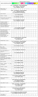
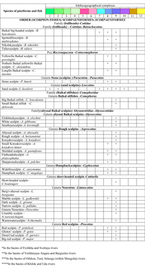
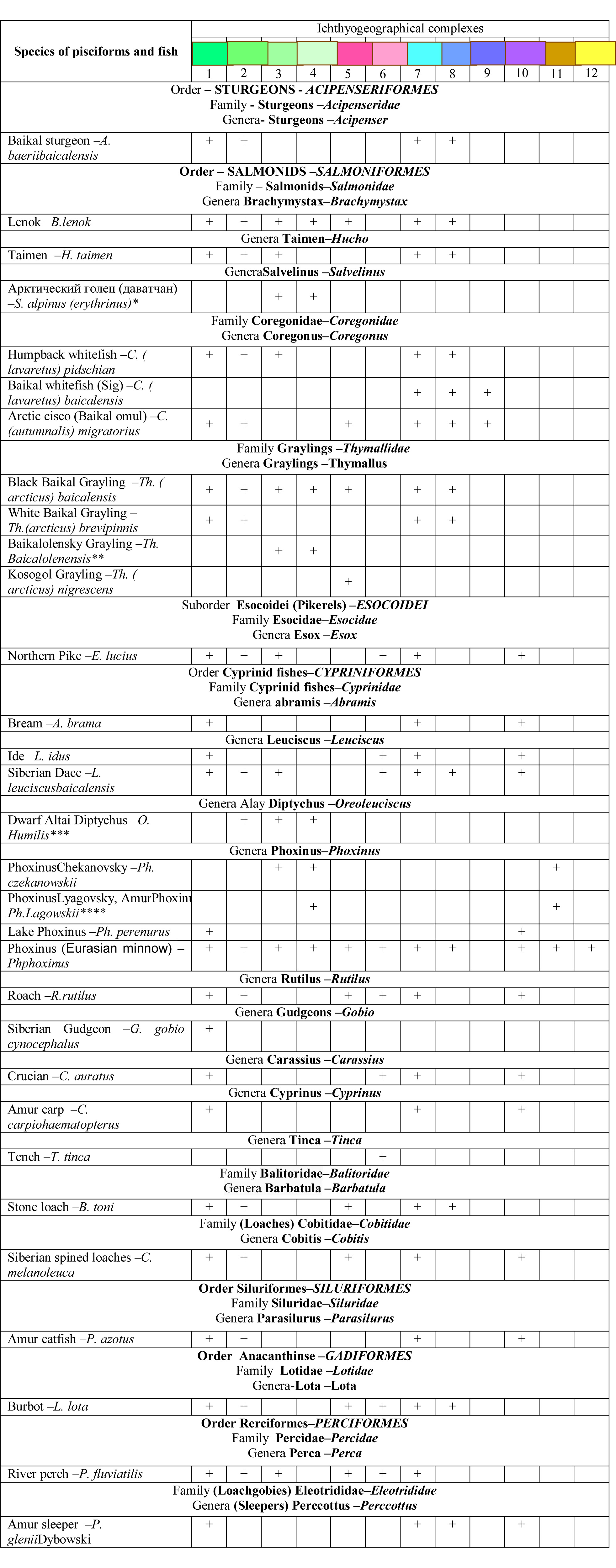
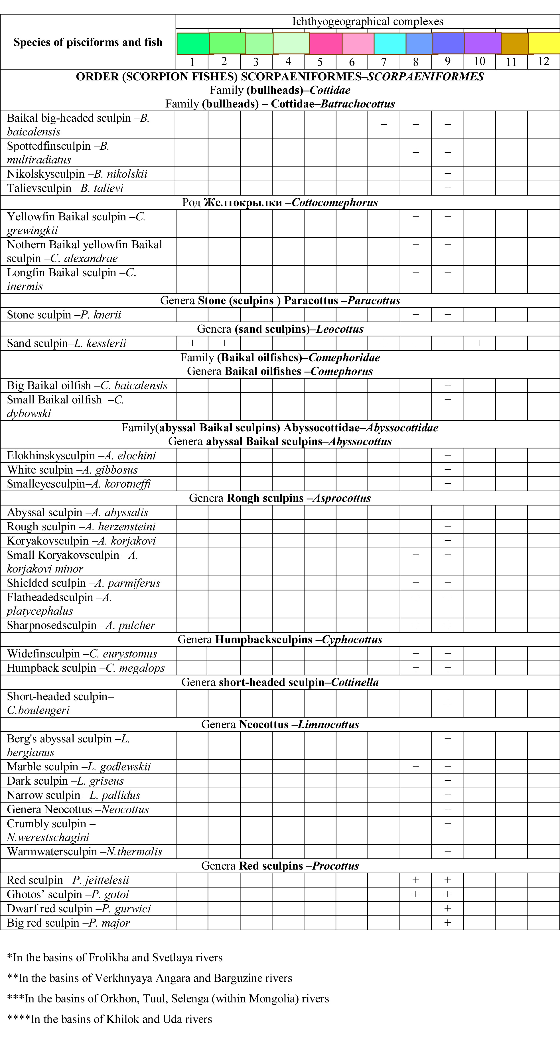
Ichthyofauna of Lake Baikal and its basin comprises 67 species and subspecies including 6 naturalized ones. Within the bounds of the lake 57 species and subspecies are registered. Out of this number 34 are endemic golomyanka-goby fishes (Cottoidei) (Table) [The freshwater fish atlas…, 2003; Fishes of…, 2007; Fishes of the Mongolian…, 1983; Sideleva, 2003]. A certain conventionality in the assessment of the fish population composition according to species and subspecies should be highlighted. In terms of biodiversity such accounting is to an extent justified, but such characterization is insufficient for the assessment of ecosystem’s operation. For instance, omul which occupies a 350-meter water column comprises 3 morphoecological fish groups with various morphological diagnoses, behavior, rates of growth, deposition of fat and breeding grounds. The same can be noted in the case of cisco (3 morphogroups) and black and white graylings.  These are young “endemic” forms. Their age is within the limits of the Holocene, but they are new stable structural-functional formations “in the bioenergetic sense equivalent” to species [Reshetnikov, 1980]. With them considered the total fish composition of the basin increases to 71, and 61 in Lake Baikal. The results of immigration of various fish species in Lake Baikal for naturalization carried out in the 20<sup>th</sup> century testify to the fact that zones of life in the lake and its food supplies are quite rigidly fixed. Out of 33 species and intraspecific forms tested for immigration only the Amur carp, catfish, sleeper and Caspian bream survived in the lake (mostly in its “peripheries”), while peled survived in the lakes of the watershed basin. Rejection of non-Baikal fish species by Lake Baikal was also reflected in the analysis of the causes of “unmixing” of the Baikal fauna with the life around the lake.</p>
<p class="a1">According to current concepts [Vereshchagin, 1935; Kozhov, 1962; Taliev, 1955, etc.], Baikal’s ichthyofauna is divided into two ecologically and genetically diverse complexes: European-Siberian and native Baikal ones. In the recent years the “neoendemics” or new young endemic offshoots of widely spread species have been registered [Timoshkin, 1995].</p>
<p class="a1">The faunal classification by G.V. Nikol’sky (1953, 1980) is usually used in the course of analysis of fish distribution according to their biotope [Kozhov, 1960]. Despite some shortcomings [Sychevskaya, 1983] this classification is rather appropriate for reflecting the ecological specificities of the faunal complexes in the conditions of one and the same water body. It enables to observe their rigid differentiation in Lake Baikal [Mamontov, 1977; Sorokin, Sorokina, 1988].</p>
<p class="a1">
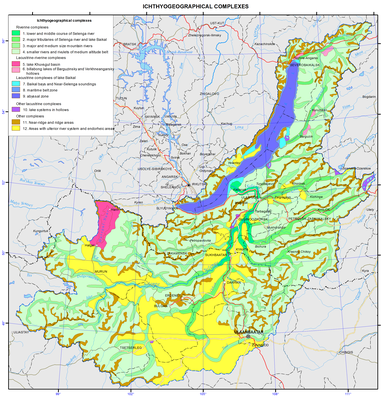
The ichthyogeographic complexes</p>
<p class="a1"><i>Lake Baikal</i></p>
<p class="a1">1. System of lakes, sors, bays and near-delta shallow waters of Lake Baikal. Inhabits the boreal plain complex – limnophiles of the coastal-sor fish group (roach, perch, pike, orfe, crucian carp, etc.) occupy the entire system of interconnected lakes, bays and sors of Lake Baikal to a depth of 10-50 m. Sturgeon is the only exception for particular distribution to depths of 180 m. In Baikal it occupies an area of limnorheophiles. The lakes near Lake Baikal (Kotokel’, Dukhovoe, and Barmashovoe) can also be included here. Their ichthyofauna composition and productivity are dependent on a degree of their connection with Lake Baikal. The highest productivity occurs with the maximum, but not complete, disjunction with Baikal. Lake Kotokel’, one of the most productive lakes, is inhabited by 15 fish species (catfish, carp, bream, roach-bream hybrid, roach, dace, nerfling, crucian carp, river perch, sand sculpin, and stoneloach).  Lake Barmashovoe, previously uninhabited by fish, is now inhabited by river perch, roach, dace, and pike, which migrated there from sor-lake Arangatuy during water level increase on Lake Baikal [Fishes of…, 2007].</p>
<p class="a0"><i>2. Coastal zone of open Baikal</i>- the boreal piedmont complex - limnorheophiles of littoral and partially sublittoral areas (taimen, grayling, lenok, minnow, loach, etc.) occupy Baikal coastal open waters to a depth of 20-70 m, rarely up to 100 m.</p>
<p class="a0"><i>3. Abyssal zone.</i> Arctic freshwater complex (cisco, lawyer, omul) populate the slope and pelagic zone to a depth of up to 350 m — the Baikal autochthonous complex. It includes endemic Baikal scorpion fish: bullheads, deep dwelling Baikal sculpins and Baikal oilfish (golomyanka) that took the entire water column of the lake with the greatest diversity of benthic forms at depths of 600-700 m.</p>
<p class="a0">Due to the fact of high capacity of proper Baikal conditions qualitative changes in fish caused quantitative expression: higher environmental capacity corresponds to the density of endemic fish population (about 65 % of the fish biomass of the lake). This complex becomes the main one ensuring successful existence of the first three, including the Baikal seal, owing to fish diet [Sideleva, 2003].</p>
<p class="a">A complex set of species of different faunal assemblages and goby fish has led to a number of features in the structure of the fish community of Lake Baikal. According to the nature of habitat and behavior of species the Baikal communities include features of ocean ecotone communities, and according to the type of population dynamics (explosive nature) and to the composition they correspond to the Siberian biocoenoses [Mamontov, 1977].</p>
<p class="a">By the abundance of fish Baikal belongs to the golomyanka-goby fish type of a water body [Koryakov, 1972]. Success in assimilating the biotic and abiotic environment of Baikal by fish species of this complex lies primarily in their original biological qualities – absence of a swim bladder (and therefore availability to the deep-dwelling habitation), increased fertility, protection of spawn, occupation of all zones for spawning within the open Baikal, and finally, removal of the embryonic development of eggs in golomyankas in pelagic zone - in the body of a female, functioning as spawning substrate [Chernyaev, 1973, 1974]. These issues are important in theoretical and practical investigations of fish fauna and its rational use.</p>
<p class="a">Increase in the number of individuals in a behavior homogeneous group leads to their increased consumption, and in the future to an increase in the population, group or other biological heterogeneity, reducing predation pressure on certain groups. This developmental pattern became widespread among Baikal slow-moving benthic organisms. The development of variability of morphological characters, color and behavior accelerated their speciation. Among 34 endemics, 28 (82.5 %) are typically benthic forms.</p>
<p class="a1">Necessity of multivariancy of individuals in a population of the pelagic fish group weakens due to the formation of a high population size of the few species with small size of their body. This vector of species evolution became possible on the basis of the pelagic larval-fry stage which contributed to dispersal and acquisition of the entire littoral zone for spawning. They include sand sculpin and yellowfin Baikal sculpin. These species occupied biotopes from the shore area to a depth of 500-700 m. Further oecizing of Lake Baikal was feasible due to vivaparity of Baikal oilfish [Taliev, 1955; Chernyaev, 1973]. As a result it became possible to disseminate fry within the confines of general currents facilitating its dispersal in the water area and to settle practically the entire water column. By the number and rate of reproduction, pelagic species prevail over other species so much that they are used in the diet of Baikal seals (nerpa) and almost all the fish of the lake, including cannibalism of gobies themselves on their own fry. This leads to the populating of Lake Baikal by fish of the common Siberian complex and the entire Lake Baikal’s ecosystem stability in time.</p>
<p class="a1">River and lake systems of the basin reflect the interchange of mountain and plain spaces. They are inhabited by interpenetrating species of the boreal piedmont, boreal plain and Arctic freshwater complex of the Arctic province. The contemporary Arctic ichthyofauna is a derivate of a more thermophilic Neogen Euro-Siberian ichthyofauna that existed in the temperate zone of Eurasia. Its modern distribution is defined by a sharp differentiation of landscape and drainage system following the Alpine orogeny at the boundary of the Pliocene and the Pleistocene accompanied by a more pronounced delimitations of climatic zones [Sychevskaya, 1983].</p>
<p class="a1">Water bodies of the watershed area are inhabited by 33 species, including 27 species in the Selenga river (20 local species, two Baikal endemics, six natiralized species and dwarf Altai osman that has recently penetrated the Selenga river basin), and nine species in Lake Khovsgol, including the endemic Kosogol grayling and naturalized Baikal omul. The endemic Baikal-Lena grayling was detected in the fluviolacustrine system of northern mountain streams, while in the Upper Kichera lakes an isolated population of coastal-pelagic omul and homotypical ichthyocenoses formed by the Baikal-Lena grayling and Arctic char (Verkhneuyakchinskie lakes) (Table) [Fishes of Lake…, 2007]. <i></i></p>
<p class="a1"><i>4. Lower and upper courses of the Selenga river </i>– packings and spawning migrations of omul, sturgeon and Siberian whitefish, habitation and spawning of Siberian whitefish, graylings, lenok, burbot, taimen, dace, roach, pike, etc.</p>
<p class="a1"><i>5. Large tributaries of the Selenga river and of Lake </i>Baikal – packings and migration of omul, lenok, grayling, taimen, burbot, dace, carp, bream, dwarf osman, etc. <i></i></p>
<p class="a1"><i>6. Large and medium mountain streams and drainage high altitude </i>lakes – habitation of grayling, lenok, taimen, common minnow, spined loach, Siberian stone loach, dace, perch, roach and pike. The Upper Kichera lakes, Kulinda and Verkhnekicherskoe – habitation of omul, pike, burbot, Siberian stone loach, grayling, sand sculpin, stone sculpin, and common minnow. Svetlinskoe lake – habitation of three species: Arctic char, common minnow and Siberian stone loach. Lake Frolikha – 11 species, including lenok, Arctic char, grayling, pike, roach, perch, burbot, lake minnow and common minnow, spined loach, sand sculpin and stone sculpin. The Verkhneyakchinskie lakes (the Yakchai river) – habitation of Arctic char (small and dwarf) in one lake and one species of Baikal-Lena grayling in the other. <i></i></p>
<p class="a1"><i>7. Small streams and creeks of the medium-altitude mountain </i>belt – possible habitation of minnows and temporary entries of grayling for spawning. <i></i></p>
<p class="a1"><i>8. Lake system of the hollows </i>– water bodies diversified in size, hydroclimatic conditions and fish composition. A cluster analysis of interrelationship of fish species was carried out in order to characterize Transbaikalian ichthyocenoses [Biodiversity…, 1999]. Two fish complexes determine the ichthyocenoses structure of the lakes: 1 – roach, perch and pike; 2 – lenok and grayling. Other fish species have subdominant value and build up the distinctness of communities. The first complex is connected with the lake limnogenesis processes, while the second – with the tectonic processes, specific for the Baikal type intermontane hollows. The Eravna lakes: in the Shchuchye lake (one of the Eravna lakes) there are peled, perch, roach and pike. Fishes from this lake underwent a thorough study of their productional characteristics. The results were used for the analysis of fishes in the water bodies of the Eravna-Kharginsk lake system. The Gusino-Ubukinskaya group, small water bodies (roach-perch lake Shchuch’e, crucian carp lakes Kamyshovoe, Krugloe, Chernoe, and perch-dace Abramovskoe lake). The total of 10 species registered: Amur sleeper, sand sculpin, spined loach, perch, burbot, lake minnow, crucian carp, dace, roach, peled and omul. Lake Gusinoe is the largest one. It is inhabited by 22 species: taimen, lenok, carp, bream, Amur catfish and Amur sleeper and farmed omul and peled. The Ivano-Arakhlei lakes (Arakhlei, Shaksha, Undugun, and Irgen) are inhabited by 16 species. Mostly they are pike, roach, dace, crucian carp, European cisco, peled and omul.<i></i></p>
<p class="a1"><i>9. Meander lakes of the Verkhneangarskaya and Barguzinskaya hollows.</i> The major lake complexes host 15 to 20 species, such as roach, perch, pike, nerfling, crucian carp, tench, carp, catfish, bream and others. There are about 7000 lakes in the Upper Angara and Kichera basins. The largest one is the eutrophic Irkana lake hosting nine species, such as roach, perch, pike, crucian carp, dace, nerfling, lake minnow, burbot and tench. The Barguzin basin lakes (4918 lakes) are inhabited by 19 fish species. In the upper course (mesotrophic) lakes there are taimen, lenok, grayling, common minnow, burbot, sand sculpin, Siberian spined loach and stoneloach. In the middle course (eutrophic) lakes there are pike, roach, perch, nerfling, crucian carp, bream, burbot, catfish, tench, carp, lake minnow, etc. In the lower course eutrophic lakes there are pike, roach, perch, dace, nerfling, crucian carp, catfish and lake minnow.<i></i></p>
<p class="a1"><i>10. Ichthyocenosis of Lake Khovsgol.</i> Nine species. The species composition has been forming since the post-glacial period. In 1957 the Baikal omul was introduced. Nowadays the water body is characterized as the lenok-grayling type of water bodies [Tugarina, 2002; Fishes…, 1983]. The majority of fishes inhabit coastal areas (grayling dwells at depths down to 25 meters, burbot – down to 30 meters) with the highest concentration in the bay and the mouth of the Khankh-Gol river. In 1957 10 million Baikal omul eggs were additionally incubated in the mouth of the Ikh- Khankh-Gol river by Professor A. Dashidorzhi of the Mongolian University. The first omul was detected in the mouth of the Ikh-Khankh-Gol river in 1971. Beyond the bay area omul has not yet been detected. Lenok inhabits the depths of 7 to 12 meters. Habitation limits in the open littoral of the western shore are confined to the 25-30 meter isobaths. The generative river form of grayling inhabits the area from the edge of water to the 25-30 meter isobaths while the generative lake form reaches down to the 80-100 meter isobaths. The roach habitation zone is limited to depths of down to 15 meters. Minnow inhabits the shore edge down to the depth of 1-1.5 meters while stoneloach – down to 1-1.3 meters. These are usually backwaters. Siberian spine loach inhabits the areas with sand and slimy ground down to the depths of 3 to 5 meters. Perch is common in the littoral at the depths down to 10-15 meters. Burbot is common everywhere within the depths of down to 40 and rarely 70 meters. All deep tributaries of Lake Khovsgol are mainly used as spawning grounds of lenok, grayling, burbot, etc. The meander lakes of the Ikh-Khoroo-Gol and Egiin-Gol rivers as well as the Ongolik Bay are the spawning grounds of perch, roach and minnow. <i></i></p>
<p class="a1"><i>11. Near water-divide and water-divide areas.</i> Small fishless lakes.<i></i></p>
<p class="a1"><i>12. Territories with ulterior river net and closed drainage areas</i> are located beyond the limits of the ichthyogeographic complexes.<i> <b></b></i></p>
<p align="center" class="a1">References:</p>
<p class="a1"><i>The freshwater fish atlas of Russia : 2 vols.</i> (2003). / ed. Yu.S. Reshetnikov, Moscow: Nauka, Vol. 1 379 p., vol 2. 253 p.</p>
<p class="a1">Korsunov, V.M., Pronin, N.M., Gonchikov, G.G. et al. (1999). <i>Biodiversity of the Baikal Siberia</i>, Novosibirsk: Nauka, 350 p.</p>
<p class="a1">Vereshchagin, G.Yu. (1935). The two typobiological complexes of Baikal. <i>Trudy Limnologicheskoi stantsii</i>, vol. 6., pp. 199-212.</p>
<p class="a1">Kozhov, M.M. (1962). <i>Biology of Lake Baikal</i>, Moscow: Izd-vo AN SSSR,  315 p.</p>
<p class="a1">Koryakov, E.A. (1972). <i>The pelagic gobies of Baikal</i>, Moscow: Nauka, 1972, 155 p.</p>
<p class="a1">Mamontov, A.M. (1977). Ichthyocenoses, their dynamics and production. <i>Limnology of the coastal-sor zone of Baikal</i>, ed. by corr. member of the Academy of Sciences of the USSR N.A. Florensov. Novosibirsk: Nauka, pp. 263-288.</p>
<p class="a1">Nikol’skiy, G.V. (1953). <i>On the biological specifics of the faunal complexes and the significance of their analysis for zoogeography</i>, Moscow-Leningrad, pp. 65-76. .</p>
<p class="a1">Nikol’skiy, G.V. (1980). The species structure and tendencies of fish variability, Moscow: Pishchevaya promyshlennost’, 183 p.</p>
<p class="a1">Pronin, N.M., Matveev, A.M., Samusenok, V.P. et al., <i>Fishes of Lake Baikal and its basin</i>, Ulan-Ude: Izd-vo BNTs SO RAN, 2007, 284 p.</p>
<p class="a1">Reshetnikov Yu.S. (1983). <i>The ecology and classification of the Coregonidae</i>, Moscow: Nauka, 301 p.</p>
<p class="a1"><i>Fishes of the Mongolian Peoples’ Republic. </i>(1983). Moscow: Nauka, 277 p.</p>
<p class="a1">Sideleva, V.G. (2003). <i>The endemic fish of Lake Baikal,</i> Backhuys Publishers, Leiden, 270 p.<b></b></p>
<p class="a1">Sorokin, V.N., Sorokina, A.A., (1988). <i>Biology of the commercial fishes of Baikal</i>, Novosibirsk: Nauka, 214 p.</p>
<p class="a1">Sychevskaya, E.K. (1983). History of formation of Mongolia’s ichthyofauna and problem of faunal complexes, <i>Fishes of the Mongolian Peoples’ Republic</i>, Moscow: Nauka, pp. 225-249.</p>
<p class="a1">Taliev, D.N. (1955). <i>Bullheads (Cottoidei) of Baikal</i>, Moscow-Leningrad: Izd-vo AN SSSR, 602 p.</p>
<p class="a1">Timoshkin, O.A. (1995). Biodiversity of Baikal faunas: contemporary level of knowledge survey and study prospects, <i>Atlas and field guide of Baikal pelagobionts</i>, Novosibirsk: Nauka. Sib. Otd-nie, pp. 25-52.</p>
<p class="a1">Tugarina, P. Ya. (2002). <i>Fish ecology of Lake Khubsugul and their fishery potential,</i> Irkutsk: Izd-vo Irkutskogo gos. un-ta, 209 p.</p>
<p class="a1">Chernyaev, Zh.A. (1973). On the genesis of the Baikal bullheads (Cottoidei), <i>Zool. zhurn.</i>, vol. 52, #3, pp. 452-453, .</p>
<p>Chernyaev, Zh.A. (1974). The Morphoecological peculiarities of reproduction and development of big Baikal oilfish Comephorus baicalensis (Pallas), <i>Vopr. ikhtiologii</i>, 14(6), p. 990-1003.</p>]]></content:encoded>
    <dc:publisher>No publisher</dc:publisher>
    <dc:creator>Alexander Ayurzhanaev</dc:creator>
    <dc:rights></dc:rights>
    <dc:date>2014-10-07T08:20:00Z</dc:date>
    <dc:type>Page</dc:type>
  </item>


  <item rdf:about="http://bic.iwlearn.org/en/atlas/atlas/38-taxonomic-diversity-map/taxonomic-diversity-map">
    <title>Taxonomic diversity map</title>
    <link>http://bic.iwlearn.org/en/atlas/atlas/38-taxonomic-diversity-map/taxonomic-diversity-map</link>
    <description></description>
    <content:encoded xmlns:content="http://purl.org/rss/1.0/modules/content/"><![CDATA[<p><img class="image-inline" src="../../../resolveuid/6668b307b7f54a229157a9ca26fee3b4/@@images/image/preview" /></p>
<p><a href="http://bic.iwlearn.org/en/atlas/photos/copy_of__38_Taxonomicdiversity.png" class="internal-link">Open full size</a></p>
<p align="center"><strong>Taxonomic diversity of soil biotic communities</strong></p>
<p align="center"><strong> </strong></p>
<p>Cartographic analysis of the spatial distribution of taxonomic diversity of invertebrate communities was carried out on the basis of the vegetation map of the Baikal basin.</p>
<p>The object of the analysis is the species (taxonomic) diversity of terrestrial invertebrates, forming community and having systemic and functional relationships. The main focus is on the mesopopulation (supraspecific taxonomic level), i.e. on relatively large invertebrates inhabiting soil and its surface.</p>
<p>The data were obtained as a result of a detailed study of the quantitative characteristics of invertebrate communities on key testing areas in taiga, mountain taiga and steppe geosystems of the Baikal basin. Numerous published and cartographic materials, information on soil cover and vegetation state were analyzed, and data on the heat and moisture supply to soils are taken into account. A method of soil-zoological and biogeocenotic studies with the application of the comparative-geographical approach was used in formulating and carrying out the work. Opportunities of landscape indication, based on theoretical concepts about the relation and interdependence of all natural components within a certain genetically homogeneous space, were used to compile map models of distribution of soil-biotic communities.</p>
<p>The structure of the animal population corresponding to the specific range of edaphic conditions ensuring normal functioning of soil organisms, was interpreted from the standpoint of the landscape-typological approach, i.e. correlation and subsequent identification (experimentally) of soil invertebrates in specific conditions of their habitat.</p>
<p>Spatial patterns of change in species diversity in gradients of environmental factors such as altitudinal zonality, temperature regime and moisture content of soil were identified on the most well-studied model groups of invertebrates in the Baikal region, namely, the representatives of the Lumbricidae, Carabidae, Staphylinidae, and Elateridae families.</p>
<p>As a result of a unified research methodology the communities of terrestrial invertebrates were united into four groups: alpine, taiga and forest, forest-steppe and steppe, and meadow and hydrophilic. Five categories of diversity of the structure were identified in each group according to the number of taxonomic units in a community: 1 - very low diversity (less than 5 taxa), 2 - low (6-10 taxa), 3 - medium (11-15 taxa), 4 - high (16-20 taxa), and 5 - very high (more than 20 taxa).</p>
<p>On the basis of the structural-dynamic analysis of differences in habitats and corresponding invertebrate complexes on the macrogeographical level, two main types of community structure are distinguished: mesothermohygrophile with a relatively small fraction of insects and a large fraction of annelids, and xeroresistant with significant participation of the class of insects. The first type includes zoocomplexes of taiga, forest and meadow biogeocenoses, represented mainly by moisture-loving forms, and the second one includes zoocomplexes of steppificated, steppes and radically anthropogenically disturbed biogeocenoses, dominated by insects with relatively short development cycles and largely adapted to moisture deficit. This corresponds to two main types of natural environment: of excess moisture - taiga with humid climate, and insufficient moisture - steppe with semihumid climate.</p>]]></content:encoded>
    <dc:publisher>No publisher</dc:publisher>
    <dc:creator>Alexander Ayurzhanaev</dc:creator>
    <dc:rights></dc:rights>
    <dc:date>2014-10-07T08:15:00Z</dc:date>
    <dc:type>Page</dc:type>
  </item>


</rdf:RDF>
