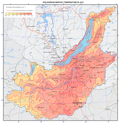
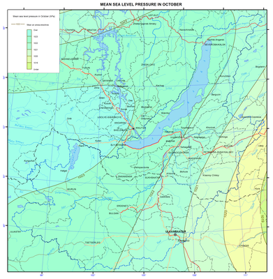
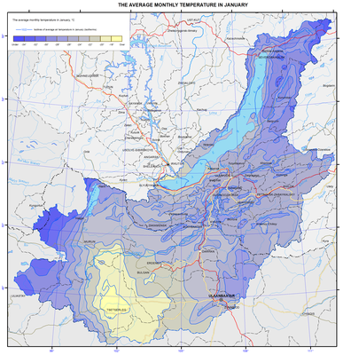
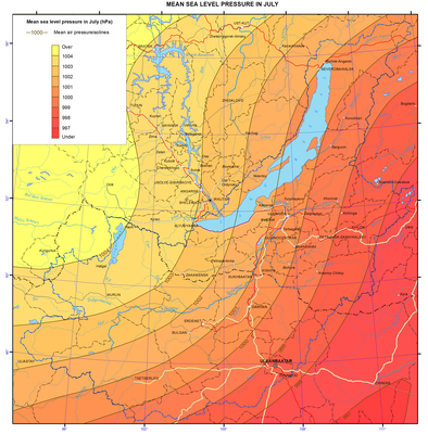
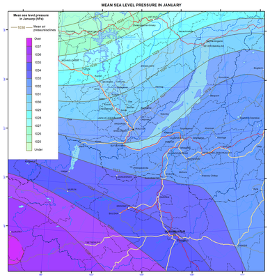
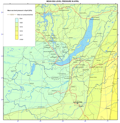
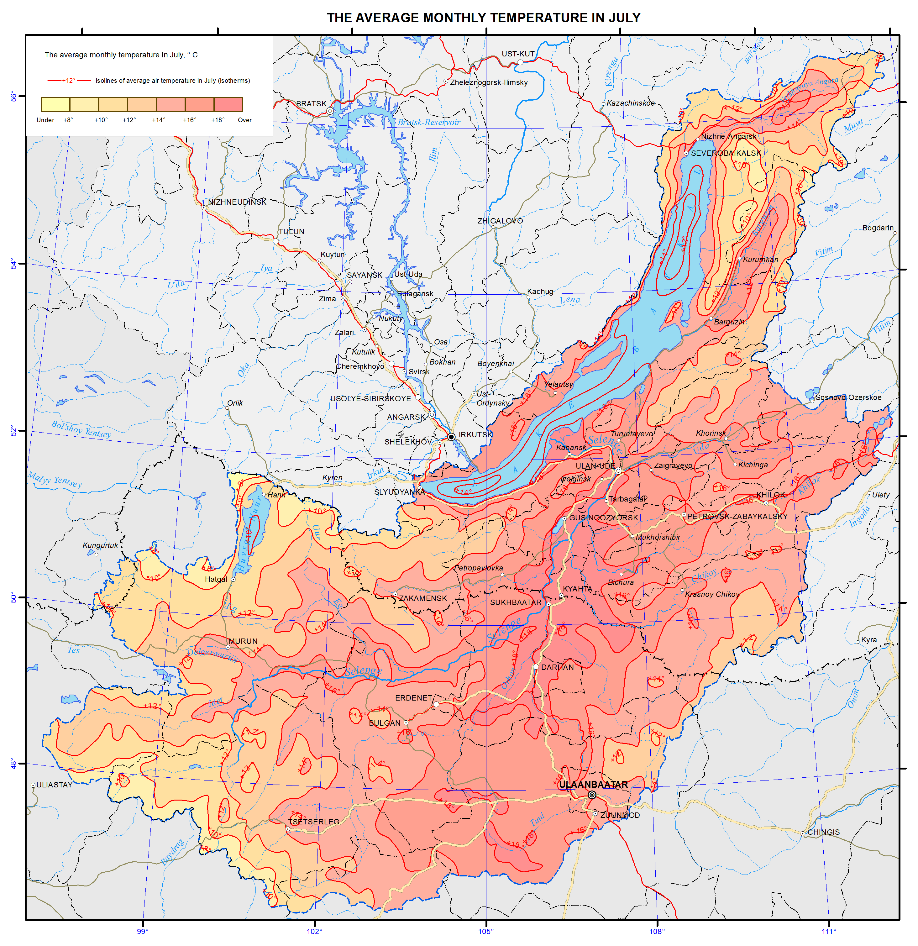
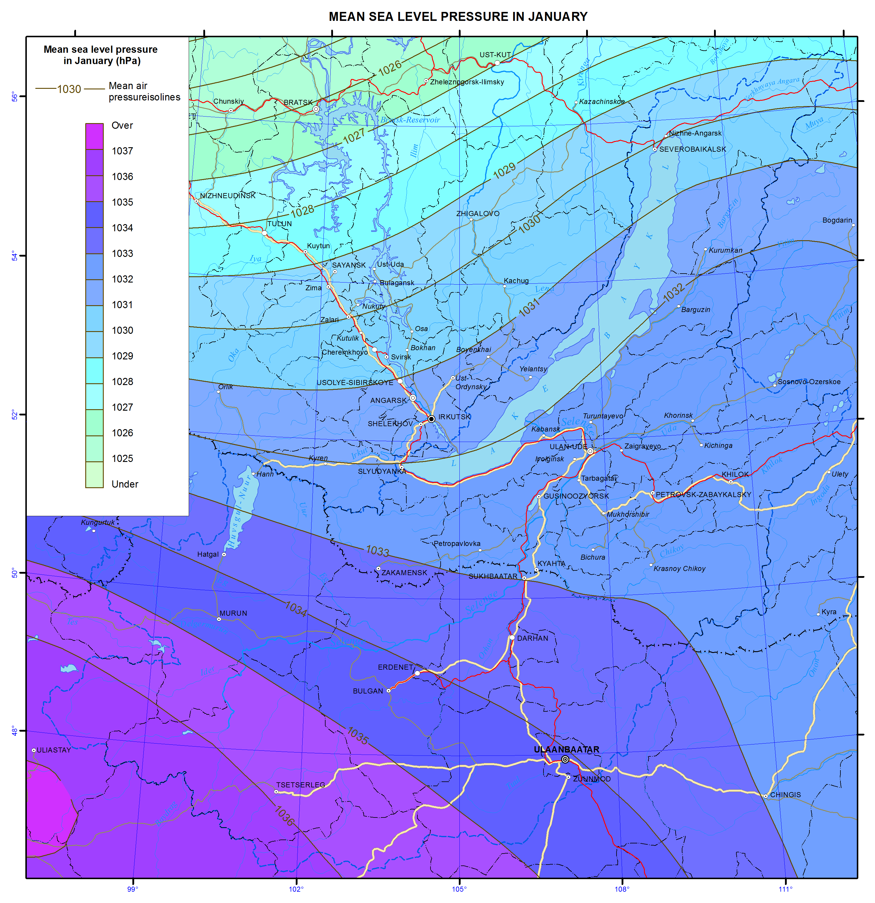
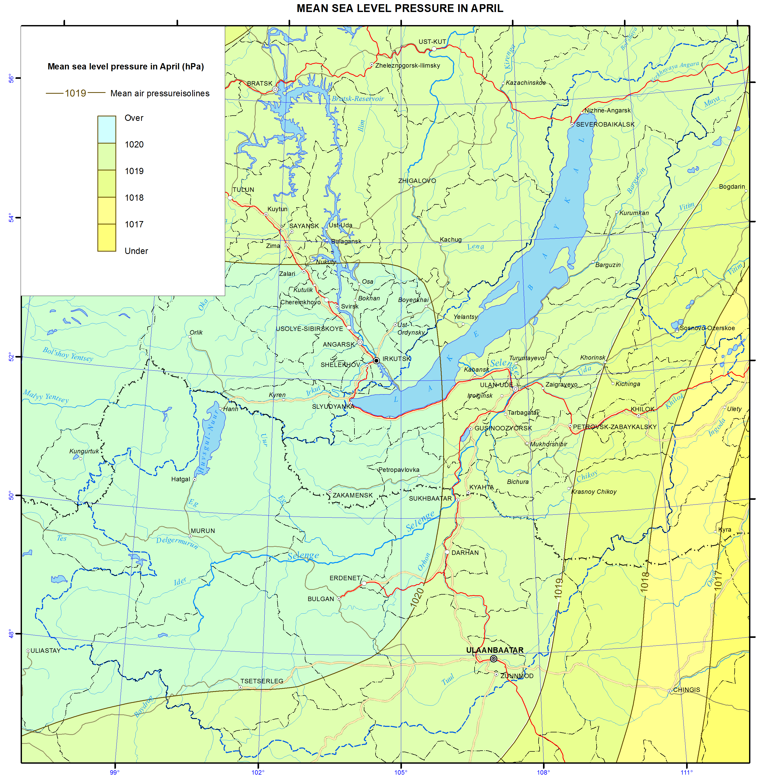
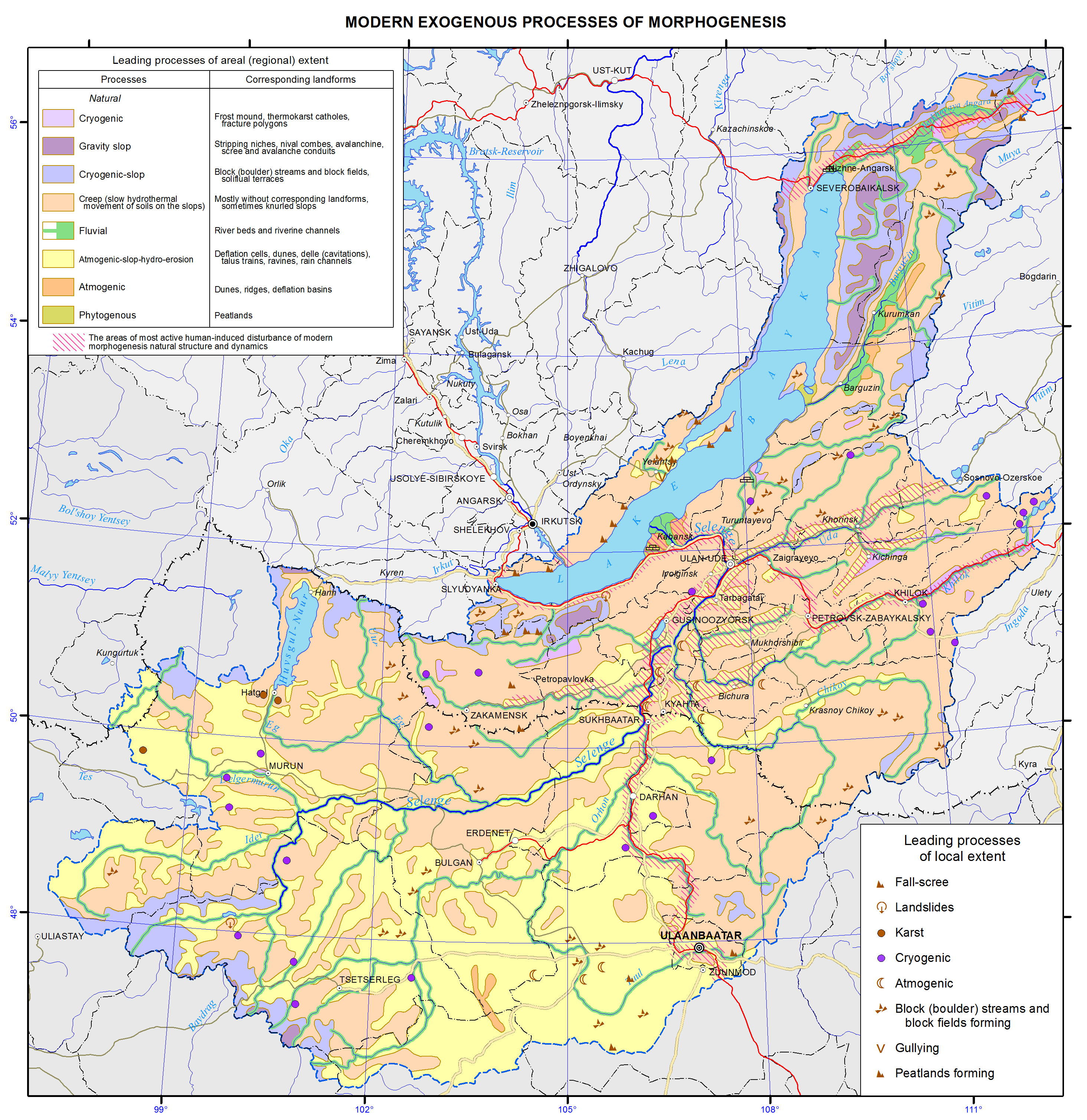
<?xml version="1.0" encoding="utf-8" ?>
<rdf:RDF xmlns:rdf="http://www.w3.org/1999/02/22-rdf-syntax-ns#" xmlns:dc="http://purl.org/dc/elements/1.1/" xmlns:syn="http://purl.org/rss/1.0/modules/syndication/" xmlns="http://purl.org/rss/1.0/">


<channel rdf:about="http://bic.iwlearn.org/en/search_rss">
  <title>English</title>
  <link>http://bic.iwlearn.org</link>

  <description>
    
            These are the search results for the query, showing results 242 to 256.
        
  </description>


  <image rdf:resource="http://bic.iwlearn.org/logo.png"/>

  <items>
    <rdf:Seq>
      
        <rdf:li rdf:resource="http://bic.iwlearn.org/en/atlas/atlas/20-average-annual-rainfall-in-mm-map/average-annual-rainfall-in-mm-map"/>
      
      
        <rdf:li rdf:resource="http://bic.iwlearn.org/en/atlas/atlas/19-amounts-of-air-temperatures-for-the-period-with-temperatures-above-10-map/amounts-of-air-temperatures-for-the-period-with-temperatures-above-10-map"/>
      
      
        <rdf:li rdf:resource="http://bic.iwlearn.org/en/atlas/atlas/18-the-average-monthly-temperature-in-july-map/the-average-monthly-temperature-in-july-map"/>
      
      
        <rdf:li rdf:resource="http://bic.iwlearn.org/en/atlas/atlas/16-mean-sea-level-pressure-in-october-map/mean-sea-level-pressure-in-october-map"/>
      
      
        <rdf:li rdf:resource="http://bic.iwlearn.org/en/atlas/atlas/17-the-average-monthly-temperature-in-january-map/the-average-monthly-temperature-in-january-map"/>
      
      
        <rdf:li rdf:resource="http://bic.iwlearn.org/en/atlas/atlas/15-mean-sea-level-pressure-in-july-map/mean-sea-level-pressure-in-july-map"/>
      
      
        <rdf:li rdf:resource="http://bic.iwlearn.org/en/atlas/atlas/13-mean-sea-level-pressure-in-january-map/mean-sea-level-pressure-in-january-map"/>
      
      
        <rdf:li rdf:resource="http://bic.iwlearn.org/en/atlas/atlas/14-mean-sea-level-pressure-in-april-map/mean-sea-level-pressure-in-april-map"/>
      
      
        <rdf:li rdf:resource="http://bic.iwlearn.org/en/atlas/atlas/12-modern-exogenous-processes-of-morphogenesis-map/modern-exogenous-processes-of-morphogenesis-map"/>
      
      
        <rdf:li rdf:resource="http://bic.iwlearn.org/en/atlas/atlas/10-geomorphology-map/geomorphology-map"/>
      
      
        <rdf:li rdf:resource="http://bic.iwlearn.org/en/atlas/atlas/11-orographic-scheme-of-lake-baikal-basin-map/orographic-scheme-of-lake-baikal-basin-map"/>
      
      
        <rdf:li rdf:resource="http://bic.iwlearn.org/en/atlas/atlas/09-steepness-of-slopes-map/steepness-of-slopes-map"/>
      
      
        <rdf:li rdf:resource="http://bic.iwlearn.org/en/atlas/atlas/08-relief-map/relief-map"/>
      
      
        <rdf:li rdf:resource="http://bic.iwlearn.org/en/atlas/atlas/07-seismic-risk-zoning-map/seismic-risk-zoning-map"/>
      
      
        <rdf:li rdf:resource="http://bic.iwlearn.org/en/atlas/atlas/06-geology-map/geology-map"/>
      
    </rdf:Seq>
  </items>

</channel>


  <item rdf:about="http://bic.iwlearn.org/en/atlas/atlas/20-average-annual-rainfall-in-mm-map/average-annual-rainfall-in-mm-map">
    <title>Average annual rainfall in mm map</title>
    <link>http://bic.iwlearn.org/en/atlas/atlas/20-average-annual-rainfall-in-mm-map/average-annual-rainfall-in-mm-map</link>
    <description></description>
    <content:encoded xmlns:content="http://purl.org/rss/1.0/modules/content/"><![CDATA[<p><img class="image-inline" src="../../../resolveuid/8800bf7b8f894145bcebc3dd7315f45f/@@images/image/preview" /></p>
<p><a href="http://bic.iwlearn.org/en/atlas/photos/copy_of__20_Averageannualrainfallinmm.png" class="internal-link">Open full size</a></p>
<p align="center"><b>Mean annual precipitation</b></p>
<p align="center"><b> </b></p>
<p>Particular features of the mountainous topography have a significant impact on the formation and distribution of precipitation over the study area. The altitude and especially the location of mountains with respect to moisture-laden air flows lead to uneven distribution of precipitation. Different precipitation amount is observed at the same altitudes of mountain ranges. The greatest precipitation amount characterizes the north-western and western slopes of primary (with regard to prevailing air flows) ridges bordering Lake Baikal, i.e. up to 1400 mm; on the windward slopes of secondary ridges and within the plateau inner areas it reaches up to 400-700 mm. Precipitation amount of 200-250 mm fall out in the steppe part of the western shore of Lake Baikal and on its islands, and up to 300 mm precipitate in the intermontane depressions and in the Selenga and Uda river valleys.</p>
<p>Annual precipitation amount of 250-300 mm falls out in the mountains of Khentei at altitudes above 1000 m, in the mountains of the Khovsgol area at altitudes above 1500 m, and in the mountains of Khangai at altitudes above 2000 m. Summer precipitation predominate, constituting 60-70% of the annual amount.</p>]]></content:encoded>
    <dc:publisher>No publisher</dc:publisher>
    <dc:creator>Alexander Ayurzhanaev</dc:creator>
    <dc:rights></dc:rights>
    <dc:date>2014-10-07T02:35:00Z</dc:date>
    <dc:type>Page</dc:type>
  </item>


  <item rdf:about="http://bic.iwlearn.org/en/atlas/atlas/19-amounts-of-air-temperatures-for-the-period-with-temperatures-above-10-map/amounts-of-air-temperatures-for-the-period-with-temperatures-above-10-map">
    <title>Amounts of air temperatures for the period with temperatures above 10 map</title>
    <link>http://bic.iwlearn.org/en/atlas/atlas/19-amounts-of-air-temperatures-for-the-period-with-temperatures-above-10-map/amounts-of-air-temperatures-for-the-period-with-temperatures-above-10-map</link>
    <description></description>
    <content:encoded xmlns:content="http://purl.org/rss/1.0/modules/content/"><![CDATA[<p><img class="image-inline" src="../../../resolveuid/f7cd3065f0644907bc34cf3c12ed62ee/@@images/image/preview" /></p>
<p><a href="http://bic.iwlearn.org/en/atlas/photos/copy2_of__19_Amountsofairtemperaturesfortheperiodwithtemperaturesabove10.png" class="internal-link">Open full size</a></p>
<p align="center"><strong>Air temperature</strong></p>
<p align="center"><strong> </strong></p>
<p>Lake Baikal influences the climate of the surrounding area within the Baikal hollow. The climate of inland areas of Irkutsk oblast, Republic of Buryatia, Zabaikalsky krai, and Mongolia may be called sharply continental, and the climate of the shore of Lake Baikal is close to the coastal one. Winter month’s temperature on the shores of southern Baikal is on average 5°C higher than in the central areas, and summer month’s temperature is lower at the same rate. In summer temperature inversions are observed over the cold lake surface that impedes upward motions. The set of radiation and circulating factors and local conditions determine the features of the thermal regime.</p>
<p>In winter, due to the predominance of anticyclonic weather, the air temperature depends mainly on the radiation conditions, and the air cools over the underlying surface. In summer, radiation factors also play a dominant role in the temperature regime formation.</p>
<p>Long-term mean annual temperature is almost everywhere negative. At stations located on the shores of Lake Baikal, air temperature is higher than on the continental stations located at the same latitudes. The coldest month is January, and the warmest one is July.</p>]]></content:encoded>
    <dc:publisher>No publisher</dc:publisher>
    <dc:creator>Alexander Ayurzhanaev</dc:creator>
    <dc:rights></dc:rights>
    <dc:date>2014-10-07T02:35:00Z</dc:date>
    <dc:type>Page</dc:type>
  </item>


  <item rdf:about="http://bic.iwlearn.org/en/atlas/atlas/18-the-average-monthly-temperature-in-july-map/the-average-monthly-temperature-in-july-map">
    <title>018. The average monthly temperature in July map</title>
    <link>http://bic.iwlearn.org/en/atlas/atlas/18-the-average-monthly-temperature-in-july-map/the-average-monthly-temperature-in-july-map</link>
    <description></description>
    <content:encoded xmlns:content="http://purl.org/rss/1.0/modules/content/"><![CDATA[<p><img class="image-inline" src="../../../resolveuid/b3b79f5f843a474e8d5abe8306083d0a/@@images/image/preview" /></p>
<p><a href="http://bic.iwlearn.org/en/atlas/photos/copy_of__18_TheaveragemonthlytemperatureinJuly.png" class="internal-link">Open full size</a></p>
<p align="center"><strong>Air temperature</strong></p>
<p align="center"><strong> </strong></p>
<p>Lake Baikal influences the climate of the surrounding area within the Baikal hollow. The climate of inland areas of Irkutsk oblast, Republic of Buryatia, Zabaikalsky krai, and Mongolia may be called sharply continental, and the climate of the shore of Lake Baikal is close to the coastal one. Winter month’s temperature on the shores of southern Baikal is on average 5°C higher than in the central areas, and summer month’s temperature is lower at the same rate. In summer temperature inversions are observed over the cold lake surface that impedes upward motions. The set of radiation and circulating factors and local conditions determine the features of the thermal regime.</p>
<p>In winter, due to the predominance of anticyclonic weather, the air temperature depends mainly on the radiation conditions, and the air cools over the underlying surface. In summer, radiation factors also play a dominant role in the temperature regime formation.</p>
<p>Long-term mean annual temperature is almost everywhere negative. At stations located on the shores of Lake Baikal, air temperature is higher than on the continental stations located at the same latitudes. The coldest month is January, and the warmest one is July.</p>]]></content:encoded>
    <dc:publisher>No publisher</dc:publisher>
    <dc:creator>Alexander Ayurzhanaev</dc:creator>
    <dc:rights></dc:rights>
    <dc:date>2014-10-07T02:30:00Z</dc:date>
    <dc:type>Page</dc:type>
  </item>


  <item rdf:about="http://bic.iwlearn.org/en/atlas/atlas/16-mean-sea-level-pressure-in-october-map/mean-sea-level-pressure-in-october-map">
    <title>016. Mean sea level pressure in October map</title>
    <link>http://bic.iwlearn.org/en/atlas/atlas/16-mean-sea-level-pressure-in-october-map/mean-sea-level-pressure-in-october-map</link>
    <description></description>
    <content:encoded xmlns:content="http://purl.org/rss/1.0/modules/content/"><![CDATA[<p><img class="image-inline" src="../../../resolveuid/3201c074e72a4a67a3a225a3aa427ef0/@@images/image/preview" /></p>
<p><a href="http://bic.iwlearn.org/en/atlas/photos/copy_of__16_MeansealevelpressureinOctober.png" class="internal-link">Open full size</a></p>
<p align="center"><strong>C</strong><strong>limate</strong></p>
<p>Observational data of meteorological stations on the air temperature and precipitation in the period of 1961 to 2008 serve as initial data for climate maps here. Mean monthly and annual values are considered.</p>
<p align="center"><strong>Atmospheric pressure</strong></p>
<p>A primary role in shaping climate is played by atmospheric circulation - one of the main climate factors. Atmospheric circulation is presented in the maps of pressure fields in the central months of seasons. The maps are compiled based on the monthly mean pressure values reduced to sea level (NCEP / NCAR reanalysis base). In winter, the main pressure system at the surface is Asian (Siberian) anticyclone centered on the north-west of Mongolia, reaching maximum development in January. In spring, the action of the Asian maximum weakens. Differences in the properties of the underlying surface of the continent and ocean reduce dramatically, thereby the zonal circulation factors begin to dominate, that determine the west-east transport. Together with the transfer of pressure formations from west to east the cyclones outputs from Central Asia and Kazakhstan are observed in spring. Summer circulation processes are characterized by the weakening of the west-east transport. The pressure field of low pressure dominates at the earth's surface. Circulation processes are characterized by the weakening of the west-east transport. At the earth's surface the pressure field of low pressure with light winds dominates. When the blocking warm anticyclone locates over the central regions of Yakutia, south cyclones from Mongolia move to the Baikal region and then they slowly travel to the west or northwest. Central forms of summer circulation, which are characterized by blockage of the zonal flow and split of planetary altitude frontal zone (PAFZ) of temperate latitudes, occur conditioned upon intensive development of the typical summer tall crests and troughs. Circulation conditions of the autumn period are characterized by the development of general west-east transport, which is interrupted by meridional invasions of cold air masses from the north. Siberian anticyclone is in its formation stage. Compared with the spring season the autumn west-east movement of pressure systems is slower. Final transition to winter conditions of circulation takes place around the middle of November, when the Siberian anticyclone is sufficiently stable.</p>]]></content:encoded>
    <dc:publisher>No publisher</dc:publisher>
    <dc:creator>Alexander Ayurzhanaev</dc:creator>
    <dc:rights></dc:rights>
    <dc:date>2014-10-07T02:30:00Z</dc:date>
    <dc:type>Page</dc:type>
  </item>


  <item rdf:about="http://bic.iwlearn.org/en/atlas/atlas/17-the-average-monthly-temperature-in-january-map/the-average-monthly-temperature-in-january-map">
    <title>017. The average monthly temperature in January map</title>
    <link>http://bic.iwlearn.org/en/atlas/atlas/17-the-average-monthly-temperature-in-january-map/the-average-monthly-temperature-in-january-map</link>
    <description></description>
    <content:encoded xmlns:content="http://purl.org/rss/1.0/modules/content/"><![CDATA[<p><img class="image-inline" src="../../../resolveuid/09a7e8a833fc4d759f83f322a9d55924/@@images/image/preview" /></p>
<p><a href="http://bic.iwlearn.org/en/atlas/photos/copy_of__17_TheaveragemonthlytemperatureinJanuary.png" class="internal-link">Open full size</a></p>
<p align="center"><strong>Air temperature</strong></p>
<p align="center"><strong> </strong></p>
<p>Lake Baikal influences the climate of the surrounding area within the Baikal hollow. The climate of inland areas of Irkutsk oblast, Republic of Buryatia, Zabaikalsky krai, and Mongolia may be called sharply continental, and the climate of the shore of Lake Baikal is close to the coastal one. Winter month’s temperature on the shores of southern Baikal is on average 5°C higher than in the central areas, and summer month’s temperature is lower at the same rate. In summer temperature inversions are observed over the cold lake surface that impedes upward motions. The set of radiation and circulating factors and local conditions determine the features of the thermal regime.</p>
<p>In winter, due to the predominance of anticyclonic weather, the air temperature depends mainly on the radiation conditions, and the air cools over the underlying surface. In summer, radiation factors also play a dominant role in the temperature regime formation.</p>
<p>Long-term mean annual temperature is almost everywhere negative. At stations located on the shores of Lake Baikal, air temperature is higher than on the continental stations located at the same latitudes. The coldest month is January, and the warmest one is July.</p>]]></content:encoded>
    <dc:publisher>No publisher</dc:publisher>
    <dc:creator>Alexander Ayurzhanaev</dc:creator>
    <dc:rights></dc:rights>
    <dc:date>2014-10-07T02:30:00Z</dc:date>
    <dc:type>Page</dc:type>
  </item>


  <item rdf:about="http://bic.iwlearn.org/en/atlas/atlas/15-mean-sea-level-pressure-in-july-map/mean-sea-level-pressure-in-july-map">
    <title>015. Mean sea level pressure in July map</title>
    <link>http://bic.iwlearn.org/en/atlas/atlas/15-mean-sea-level-pressure-in-july-map/mean-sea-level-pressure-in-july-map</link>
    <description></description>
    <content:encoded xmlns:content="http://purl.org/rss/1.0/modules/content/"><![CDATA[<p><img class="image-inline" src="../../../resolveuid/b6eb3286f92c47edb9dd998eac42bb27/@@images/image/preview" /></p>
<p><a href="http://bic.iwlearn.org/en/atlas/photos/copy_of__15_MeansealevelpressureinJuly.png" class="internal-link">Open full size</a></p>
<p align="center"><strong>C</strong><strong>limate</strong><span> </span></p>
<p>Observational data of meteorological stations on the air temperature and precipitation in the period of 1961 to 2008 serve as initial data for climate maps here. Mean monthly and annual values are considered.</p>
<p align="center"><strong>Atmospheric pressure</strong><span> </span></p>
<p>A primary role in shaping climate is played by atmospheric circulation - one of the main climate factors. Atmospheric circulation is presented in the maps of pressure fields in the central months of seasons. The maps are compiled based on the monthly mean pressure values reduced to sea level (NCEP / NCAR reanalysis base). In winter, the main pressure system at the surface is Asian (Siberian) anticyclone centered on the north-west of Mongolia, reaching maximum development in January. In spring, the action of the Asian maximum weakens. Differences in the properties of the underlying surface of the continent and ocean reduce dramatically, thereby the zonal circulation factors begin to dominate, that determine the west-east transport. Together with the transfer of pressure formations from west to east the cyclones outputs from Central Asia and Kazakhstan are observed in spring. Summer circulation processes are characterized by the weakening of the west-east transport. The pressure field of low pressure dominates at the earth's surface. Circulation processes are characterized by the weakening of the west-east transport. At the earth's surface the pressure field of low pressure with light winds dominates. When the blocking warm anticyclone locates over the central regions of Yakutia, south cyclones from Mongolia move to the Baikal region and then they slowly travel to the west or northwest. Central forms of summer circulation, which are characterized by blockage of the zonal flow and split of planetary altitude frontal zone (PAFZ) of temperate latitudes, occur conditioned upon intensive development of the typical summer tall crests and troughs. Circulation conditions of the autumn period are characterized by the development of general west-east transport, which is interrupted by meridional invasions of cold air masses from the north. Siberian anticyclone is in its formation stage. Compared with the spring season the autumn west-east movement of pressure systems is slower. Final transition to winter conditions of circulation takes place around the middle of November, when the Siberian anticyclone is sufficiently stable.</p>]]></content:encoded>
    <dc:publisher>No publisher</dc:publisher>
    <dc:creator>Alexander Ayurzhanaev</dc:creator>
    <dc:rights></dc:rights>
    <dc:date>2014-10-07T02:25:00Z</dc:date>
    <dc:type>Page</dc:type>
  </item>


  <item rdf:about="http://bic.iwlearn.org/en/atlas/atlas/13-mean-sea-level-pressure-in-january-map/mean-sea-level-pressure-in-january-map">
    <title>013. Mean sea level pressure in January map</title>
    <link>http://bic.iwlearn.org/en/atlas/atlas/13-mean-sea-level-pressure-in-january-map/mean-sea-level-pressure-in-january-map</link>
    <description></description>
    <content:encoded xmlns:content="http://purl.org/rss/1.0/modules/content/"><![CDATA[<p><img class="image-inline" src="../../../resolveuid/dadde0a0dd7c41af8359527b1bd93715/@@images/image/preview" /></p>
<p><a href="http://bic.iwlearn.org/en/atlas/photos/copy_of__13_MeansealevelpressureinJanuary.png" class="internal-link">Open full size</a></p>
<p align="center"><strong>C</strong><strong>limate</strong></p>
<p align="center"><strong> </strong></p>
<p>Observational data of meteorological stations on the air temperature and precipitation in the period of 1961 to 2008 serve as initial data for climate maps here. Mean monthly and annual values are considered.</p>
<p align="center"><strong>Atmospheric pressure</strong></p>
<p align="center"><strong> </strong></p>
<p>A primary role in shaping climate is played by atmospheric circulation - one of the main climate factors. Atmospheric circulation is presented in the maps of pressure fields in the central months of seasons. The maps are compiled based on the monthly mean pressure values reduced to sea level (NCEP / NCAR reanalysis base). In winter, the main pressure system at the surface is Asian (Siberian) anticyclone centered on the north-west of Mongolia, reaching maximum development in January. In spring, the action of the Asian maximum weakens. Differences in the properties of the underlying surface of the continent and ocean reduce dramatically, thereby the zonal circulation factors begin to dominate, that determine the west-east transport. Together with the transfer of pressure formations from west to east the cyclones outputs from Central Asia and Kazakhstan are observed in spring. Summer circulation processes are characterized by the weakening of the west-east transport. The pressure field of low pressure dominates at the earth's surface. Circulation processes are characterized by the weakening of the west-east transport. At the earth's surface the pressure field of low pressure with light winds dominates. When the blocking warm anticyclone locates over the central regions of Yakutia, south cyclones from Mongolia move to the Baikal region and then they slowly travel to the west or northwest. Central forms of summer circulation, which are characterized by blockage of the zonal flow and split of planetary altitude frontal zone (PAFZ) of temperate latitudes, occur conditioned upon intensive development of the typical summer tall crests and troughs. Circulation conditions of the autumn period are characterized by the development of general west-east transport, which is interrupted by meridional invasions of cold air masses from the north. Siberian anticyclone is in its formation stage. Compared with the spring season the autumn west-east movement of pressure systems is slower. Final transition to winter conditions of circulation takes place around the middle of November, when the Siberian anticyclone is sufficiently stable.</p>]]></content:encoded>
    <dc:publisher>No publisher</dc:publisher>
    <dc:creator>Alexander Ayurzhanaev</dc:creator>
    <dc:rights></dc:rights>
    <dc:date>2014-10-07T02:20:00Z</dc:date>
    <dc:type>Page</dc:type>
  </item>


  <item rdf:about="http://bic.iwlearn.org/en/atlas/atlas/14-mean-sea-level-pressure-in-april-map/mean-sea-level-pressure-in-april-map">
    <title>014. Mean sea level pressure in April map</title>
    <link>http://bic.iwlearn.org/en/atlas/atlas/14-mean-sea-level-pressure-in-april-map/mean-sea-level-pressure-in-april-map</link>
    <description></description>
    <content:encoded xmlns:content="http://purl.org/rss/1.0/modules/content/"><![CDATA[<p><img class="image-inline" src="../../../resolveuid/fd26487eb3ea4ec5966d84609ea88860/@@images/image/preview" /></p>
<p><a href="http://bic.iwlearn.org/en/atlas/photos/copy_of__14_MeansealevelpressureinApril.png" class="internal-link">Open full size</a></p>
<p align="center"><strong>C</strong><strong>limate</strong></p>
<p>Observational data of meteorological stations on the air temperature and precipitation in the period of 1961 to 2008 serve as initial data for climate maps here. Mean monthly and annual values are considered.</p>
<p align="center"><strong>Atmospheric pressure</strong><span> </span></p>
<p>A primary role in shaping climate is played by atmospheric circulation - one of the main climate factors. Atmospheric circulation is presented in the maps of pressure fields in the central months of seasons. The maps are compiled based on the monthly mean pressure values reduced to sea level (NCEP / NCAR reanalysis base). In winter, the main pressure system at the surface is Asian (Siberian) anticyclone centered on the north-west of Mongolia, reaching maximum development in January. In spring, the action of the Asian maximum weakens. Differences in the properties of the underlying surface of the continent and ocean reduce dramatically, thereby the zonal circulation factors begin to dominate, that determine the west-east transport. Together with the transfer of pressure formations from west to east the cyclones outputs from Central Asia and Kazakhstan are observed in spring. Summer circulation processes are characterized by the weakening of the west-east transport. The pressure field of low pressure dominates at the earth's surface. Circulation processes are characterized by the weakening of the west-east transport. At the earth's surface the pressure field of low pressure with light winds dominates. When the blocking warm anticyclone locates over the central regions of Yakutia, south cyclones from Mongolia move to the Baikal region and then they slowly travel to the west or northwest. Central forms of summer circulation, which are characterized by blockage of the zonal flow and split of planetary altitude frontal zone (PAFZ) of temperate latitudes, occur conditioned upon intensive development of the typical summer tall crests and troughs. Circulation conditions of the autumn period are characterized by the development of general west-east transport, which is interrupted by meridional invasions of cold air masses from the north. Siberian anticyclone is in its formation stage. Compared with the spring season the autumn west-east movement of pressure systems is slower. Final transition to winter conditions of circulation takes place around the middle of November, when the Siberian anticyclone is sufficiently stable.</p>]]></content:encoded>
    <dc:publisher>No publisher</dc:publisher>
    <dc:creator>Alexander Ayurzhanaev</dc:creator>
    <dc:rights></dc:rights>
    <dc:date>2014-10-07T02:20:00Z</dc:date>
    <dc:type>Page</dc:type>
  </item>


  <item rdf:about="http://bic.iwlearn.org/en/atlas/atlas/12-modern-exogenous-processes-of-morphogenesis-map/modern-exogenous-processes-of-morphogenesis-map">
    <title>012. Modern exogenous processes of morphogenesis map</title>
    <link>http://bic.iwlearn.org/en/atlas/atlas/12-modern-exogenous-processes-of-morphogenesis-map/modern-exogenous-processes-of-morphogenesis-map</link>
    <description></description>
    <content:encoded xmlns:content="http://purl.org/rss/1.0/modules/content/"><![CDATA[<p><img class="image-inline" src="../../../resolveuid/234afefba30c4bd0afa15d0b1013192d/@@images/image/preview" /></p>
<p><a href="http://bic.iwlearn.org/en/atlas/photos/copy_of__12_Modernexogenousprocessesofmorphogenesis.png" class="internal-link">Open full size</a></p>
<p align="center"><strong>Contemporary exogenous processes of morphogenesis</strong></p>
<p class="NormalWeb">For purposes of mapping, the leading processes were identified on the basis of a classification of the exogenous processes of morphogenesis of land, suggested by V. B. Vyrkin [1986], from taxonomic geomorphological units in accordance with the scale. At a small scale, the objects of geomorphological mapping are the types, subtypes and complexes of topography which are basic to identifying classes and groups of leading processes. The legend is based on identifying one leading process (the one exception to this rule is represented by the display of areas on the map where the contemporary morphogenesis is due to a combination of two leading classes of processes). Identification of the leading processes of the territory took into account their three main parameters: the coverage area, the duration of a continuous occurrence, and the intensity of development.</p>
<p class="NormalWeb">The process is identified through a process interpretation of the relief, deposits, landscapes, vegetation and other natural formations. The procedure brings to the fore the interpretation of the relief, its morphology, genesis and age, and the identification of the genetic types of deposits. Only an integral investigation into the landforms and correlative deposits, complemented with station-based observations of the intensity of processes, does make it possible to identify in the mapping procedure the leading processes, and of paramount importance is a knowledge of the geomorphological structure of the region being mapped. Vital to the generation of small- and medium-scale maps of the processes, especially for poorly explored spaces of Siberia and Mongolia, are space images. In Siberia’s remote regions difficult of access, space images provide the main information base for map compilation.</p>
<p>Thus the methodological framework for mapping the contemporary exogenous processes of morphogenesis involves determining and depicting the leading processes. Maps as produced by such a method offer a means of investigating the structure and functioning of the processes of contemporary exogenous morphogenesis. They can be used in developing and generating regionalization schemes for contemporary exogenous processes of morphogenesis.</p>
<p>The map as created on the basis of the aforementioned principles constitutes a wealth of information which can be employed in dealing with issues relating to rational management of natural resources, assessments of the relief and contemporary morphogenetic processes, and to implementation of measures for the protection of land surface against hazardous and adverse geomorphological processes.</p>]]></content:encoded>
    <dc:publisher>No publisher</dc:publisher>
    <dc:creator>Alexander Ayurzhanaev</dc:creator>
    <dc:rights></dc:rights>
    <dc:date>2014-10-07T02:20:00Z</dc:date>
    <dc:type>Page</dc:type>
  </item>


  <item rdf:about="http://bic.iwlearn.org/en/atlas/atlas/10-geomorphology-map/geomorphology-map">
    <title>010. Geomorphology map</title>
    <link>http://bic.iwlearn.org/en/atlas/atlas/10-geomorphology-map/geomorphology-map</link>
    <description></description>
    <content:encoded xmlns:content="http://purl.org/rss/1.0/modules/content/"><![CDATA[<p><img class="image-inline" src="../../../resolveuid/c774bed0354a4476a8456f4f05882d31/@@images/image/preview" /></p>
<p><a href="http://bic.iwlearn.org/en/atlas/photos/copy_of__10_Geomorphology.png" class="internal-link">Open full size</a></p>
<p align="center"><strong>Geomorphology</strong></p>
<p>The Baikal basin is located in the center of Eurasia, which determines its specific traits as well as the main features of nature. Paleogeography and geology of the region govern its peculiar landforms.</p>
<p>Vertical tectonic movements of the Late Mesozoic and the Cenozoic developed a mountain-basin type of topography.</p>
<p>The orographic structure of the Baikal basin is rather complex. The topography as a whole is a unified Pliocene-Quaternary formation [Ecosystems, 2005]. Significant subsidence of individual blocks in the midst of general uplift developed grabens of two types. The first type (the Baikal type) is associated with the intensification of tectonic activity in the inland Baikal Rift Zone. The amplitude of vertical neotectonic movements, as well as the thickness of loose deposits reach their maximum here. Crustal movements in this area are still quite intense; they cause a high seismic activity with frequent and sometimes strong earthquakes. The second type (the Transbaikalian type) is represented by wide intermountain lowlands, which are very common in the Selenga river basin. They formed as a result of recent deep-seated tectonic dislocations superimposed on the rejuvenated Mesozoic depressions.</p>
<p>Intermountain basins are separated by mountain ranges varying in height and geological structure. They are noticeably dissected by exogenous processes of erosion.</p>
<p>In the Quaternary, the highest orographic units (the Baikalsky, Verkhneangarsky, Barguzinsky, Khamar-Daban, Khangai and other mountain ranges), especially their north-western and northern slopes, were exposed to glaciation, which is indicated by the presence of the alpine landforms (cirques, avalanche chutes, through valleys, moraines, etc.)</p>
<p>Both positive and negative landforms within the Selenga river catchment area basin and up to the Uda river mouth are generally directed northeastward with a dominant altitude lowering northward. The mountains surrounding of three Baikal intermountain basins (Barguzin, Verkhneangarsk and Khovsgol lowlands) are characterized by higher absolute altitudes and deeply cut river valleys. These factors predetermine a wide range of elements typical of mountain landform, or plain landform in the wide intermountain basins.</p>
<p>According to the geomorphological zoning [Highlands…, 1974; National Atlas of the Mongolian People’s Republic, 1990] the area of the Baikal basin is made up of the following features: Khangai and Khentei-Dauria highlands, Khovsgol mountains, Orkhon-Selenga middle mountains and its continuation in the north - Selenga (Selenginskaya Dauria) middle mountains, mountain systems of the Dzhidinsky mountainous region, mountain ranges of Khamar-Daban, Ulan-Burgasy, Ikatsky, Barguzinsky, Verkhneangarsky, Severomuisky, Baikalsky, and Primorsky, and the western side of the Vitim Plateau. Minimum absolute altitude is the Lake Baikal waterline; since it is regulated, it is subjected to slight fluctuations at around 460 m a.s.l. Maximum absolute altitude is 3,539 m a.s.l. (the Khangai Highland).</p>
<p>The highest mountain range in the area is the Khangai Highland located in the south-western part of the basin; it has generally subdued delineation and slight changes of relative altitudes. The mountains become more prominent towards the central part of the basin due to Alpine landforms. Tarbagatai and Telin-Tsagan are the largest northern spurs of Khangai Highlands with individual peaks reaching 2,500 m.</p>
<p>The maximum altitudes of the Khentei Highland mountains go up to 2,200-2,400 m a.s.l. Their wide and long spurs stretch westward and eastward, forming a large highland, gradually descending to low hills in the west and in the south, and joining the mountains of Transbaikalia in the north. Generally, this is a gently sloping landscape with wide-spread residual hills, rocks, and scattered stones. Traces of ancient glaciation are preserved to a limited extent.</p>
<p>The Orkhon-Selenga middle mountains are located in the central part of the watershed basin between the ranges of the Dzhida river basin in the north and the Khentei Highlands in the south. It features a flattened relief and its spatial configuration resembles a huge amphitheater descending towards the northeast.</p>
<p>The Selenga middle mountains consist of sublatitudinal medium-altitude mountain ranges with rounded summits (Tsagan-Daban, Borgoisky, Chikoysky, Tsagan-Khurteisky, Zagansky, and others) separated by wide intermountain valleys distinctly stretching along the main riverbeds. The valley bottoms are drained by the Selenga tributaries (Chikoy, Khilok, Uda, Dzhida) and composed of alluvial and proluvial deposits of different age arranged in terraces and wide piedmont plains. The Selenga river valley lies among low hills with granite residuals, rocks, and cliffs.</p>
<p>The Khovsgol area relief has a complex structure. Its west side features sharp-crested, steep-sided, and hard to access ridges of Bayan-Ula and Khoridol-Saryag. The outlines of the mountains to the east of Lake Khovsgol resemble those of the northern Khentei with altitudes over 2,000 m. Extensive Late Cenosoic lava plateaus are specific features of these mountains.</p>
<p class="a">The Dzhida and Khamar-Damban Mountain Ranges have a lot in common. They stretch from the south-west to the north-east. In the west, they are relatively flattened and marked by bald peaks, gradually turning into the alpinotype middle mountains of the Big Khamar-Daban Mountain Range, which drops steeply to the shores of Lake Baikal. In the east, the mountains have a lower altitude. The Selenga river cuts through their spurs.</p>
<p>The northern part of Lake Baikal and the Verkhneangarskaya basin are surrounded by Alpine landforms with harsh outlines of the axial and piedmont parts of the Baikalsky, Verkhneangarsky, Severomuisky, and Barguzinsky mountain ranges. In spite of the relatively moderate elevations, there are many glacial traces here, and in some places there are small vanishing mountain glaciers (e.g. the Chersky Glacier – about 0.4 km2) The Vekhneangarsky basin relief shows little elevation changes at the bottom. It is formed by the alluvial deposits of the Verkhnyaya Angara (the Upper Angara) river, and by lacustrine alluvial deposits of paleobasins. Extensive proluvial and fluvioglacial piedmont plains are typical of the basin.</p>
<p>The structure of the Barguzinskya basin is typical of the Baikal-type depressions: large swampy plain areas at the basin bottom, and relatively uplifted ancient alluvial lacustrine terraces made of sandstone deposits. The presence of large areas of sandstone deposits predetermines high eolian activity.</p>
<p>In the south, the Barguzinskaya depression is framed by massive, but relatively flat landforms of the Ikatsky range. The highest summits of the Ikatsky range as well as those of the ranges lying further south (Ulan-Burgasy and Kurbinsky ranges) are treeless and flat with mountain terraces. <b> </b></p>
<p align="center"><b> </b></p>
<p align="center">References<i></i></p>
<p>Logachev, N.A., Antoshchenko-Olenev, I.V., Bazarov, D.B. et al. (1974). <i>Highlands of Cisbaikalia and Transbaikalia.</i> Moscow: Nauka, 360 p.</p>
<p> </p>
<p><i>Ecosystems of the Selenga  basin (Biological Resources and Natural Conditions of Mongolia: Proceedings of the Joint Russian-Mongolian Complex Biological Expedition; vol. 44)</i>, (2005). Executive Editors: E.A. Vostokova and P.D. Gunin. Moscow: Nauka, 359 p.</p>]]></content:encoded>
    <dc:publisher>No publisher</dc:publisher>
    <dc:creator>Alexander Ayurzhanaev</dc:creator>
    <dc:rights></dc:rights>
    <dc:date>2014-10-07T02:15:00Z</dc:date>
    <dc:type>Page</dc:type>
  </item>


  <item rdf:about="http://bic.iwlearn.org/en/atlas/atlas/11-orographic-scheme-of-lake-baikal-basin-map/orographic-scheme-of-lake-baikal-basin-map">
    <title>011. Orographic scheme of Lake Baikal basin map</title>
    <link>http://bic.iwlearn.org/en/atlas/atlas/11-orographic-scheme-of-lake-baikal-basin-map/orographic-scheme-of-lake-baikal-basin-map</link>
    <description></description>
    <content:encoded xmlns:content="http://purl.org/rss/1.0/modules/content/"><![CDATA[<p><img class="image-inline" src="../../../resolveuid/0230445935314ef28902e25f9ddbcc45/@@images/image/preview" /></p>
<p><a href="http://bic.iwlearn.org/en/atlas/photos/copy_of__11_OrographicSchemeofLakeBaikalBasin.png" class="internal-link">Open full size</a></p>
<p align="center"><strong>Geomorphology</strong></p>
<p>The Baikal basin is located in the center of Eurasia, which determines its specific traits as well as the main features of nature. Paleogeography and geology of the region govern its peculiar landforms.</p>
<p>Vertical tectonic movements of the Late Mesozoic and the Cenozoic developed a mountain-basin type of topography.</p>
<p>The orographic structure of the Baikal basin is rather complex. The topography as a whole is a unified Pliocene-Quaternary formation [Ecosystems, 2005]. Significant subsidence of individual blocks in the midst of general uplift developed grabens of two types. The first type (the Baikal type) is associated with the intensification of tectonic activity in the inland Baikal Rift Zone. The amplitude of vertical neotectonic movements, as well as the thickness of loose deposits reach their maximum here. Crustal movements in this area are still quite intense; they cause a high seismic activity with frequent and sometimes strong earthquakes. The second type (the Transbaikalian type) is represented by wide intermountain lowlands, which are very common in the Selenga river basin. They formed as a result of recent deep-seated tectonic dislocations superimposed on the rejuvenated Mesozoic depressions.</p>
<p>Intermountain basins are separated by mountain ranges varying in height and geological structure. They are noticeably dissected by exogenous processes of erosion.</p>
<p>In the Quaternary, the highest orographic units (the Baikalsky, Verkhneangarsky, Barguzinsky, Khamar-Daban, Khangai and other mountain ranges), especially their north-western and northern slopes, were exposed to glaciation, which is indicated by the presence of the alpine landforms (cirques, avalanche chutes, through valleys, moraines, etc.)</p>
<p>Both positive and negative landforms within the Selenga river catchment area basin and up to the Uda river mouth are generally directed northeastward with a dominant altitude lowering northward. The mountains surrounding of three Baikal intermountain basins (Barguzin, Verkhneangarsk and Khovsgol lowlands) are characterized by higher absolute altitudes and deeply cut river valleys. These factors predetermine a wide range of elements typical of mountain landform, or plain landform in the wide intermountain basins.</p>
<p>According to the geomorphological zoning [Highlands…, 1974; National Atlas of the Mongolian People’s Republic, 1990] the area of the Baikal basin is made up of the following features: Khangai and Khentei-Dauria highlands, Khovsgol mountains, Orkhon-Selenga middle mountains and its continuation in the north - Selenga (Selenginskaya Dauria) middle mountains, mountain systems of the Dzhidinsky mountainous region, mountain ranges of Khamar-Daban, Ulan-Burgasy, Ikatsky, Barguzinsky, Verkhneangarsky, Severomuisky, Baikalsky, and Primorsky, and the western side of the Vitim Plateau. Minimum absolute altitude is the Lake Baikal waterline; since it is regulated, it is subjected to slight fluctuations at around 460 m a.s.l. Maximum absolute altitude is 3,539 m a.s.l. (the Khangai Highland).</p>
<p>The highest mountain range in the area is the Khangai Highland located in the south-western part of the basin; it has generally subdued delineation and slight changes of relative altitudes. The mountains become more prominent towards the central part of the basin due to Alpine landforms. Tarbagatai and Telin-Tsagan are the largest northern spurs of Khangai Highlands with individual peaks reaching 2,500 m.</p>
<p>The maximum altitudes of the Khentei Highland mountains go up to 2,200-2,400 m a.s.l. Their wide and long spurs stretch westward and eastward, forming a large highland, gradually descending to low hills in the west and in the south, and joining the mountains of Transbaikalia in the north. Generally, this is a gently sloping landscape with wide-spread residual hills, rocks, and scattered stones. Traces of ancient glaciation are preserved to a limited extent.</p>
<p>The Orkhon-Selenga middle mountains are located in the central part of the watershed basin between the ranges of the Dzhida river basin in the north and the Khentei Highlands in the south. It features a flattened relief and its spatial configuration resembles a huge amphitheater descending towards the northeast.</p>
<p>The Selenga middle mountains consist of sublatitudinal medium-altitude mountain ranges with rounded summits (Tsagan-Daban, Borgoisky, Chikoysky, Tsagan-Khurteisky, Zagansky, and others) separated by wide intermountain valleys distinctly stretching along the main riverbeds. The valley bottoms are drained by the Selenga tributaries (Chikoy, Khilok, Uda, Dzhida) and composed of alluvial and proluvial deposits of different age arranged in terraces and wide piedmont plains. The Selenga river valley lies among low hills with granite residuals, rocks, and cliffs.</p>
<p>The Khovsgol area relief has a complex structure. Its west side features sharp-crested, steep-sided, and hard to access ridges of Bayan-Ula and Khoridol-Saryag. The outlines of the mountains to the east of Lake Khovsgol resemble those of the northern Khentei with altitudes over 2,000 m. Extensive Late Cenosoic lava plateaus are specific features of these mountains.</p>
<p class="a">The Dzhida and Khamar-Damban Mountain Ranges have a lot in common. They stretch from the south-west to the north-east. In the west, they are relatively flattened and marked by bald peaks, gradually turning into the alpinotype middle mountains of the Big Khamar-Daban Mountain Range, which drops steeply to the shores of Lake Baikal. In the east, the mountains have a lower altitude. The Selenga river cuts through their spurs.</p>
<p>The northern part of Lake Baikal and the Verkhneangarskaya basin are surrounded by Alpine landforms with harsh outlines of the axial and piedmont parts of the Baikalsky, Verkhneangarsky, Severomuisky, and Barguzinsky mountain ranges. In spite of the relatively moderate elevations, there are many glacial traces here, and in some places there are small vanishing mountain glaciers (e.g. the Chersky Glacier – about 0.4 km2) The Vekhneangarsky basin relief shows little elevation changes at the bottom. It is formed by the alluvial deposits of the Verkhnyaya Angara (the Upper Angara) river, and by lacustrine alluvial deposits of paleobasins. Extensive proluvial and fluvioglacial piedmont plains are typical of the basin.</p>
<p>The structure of the Barguzinskya basin is typical of the Baikal-type depressions: large swampy plain areas at the basin bottom, and relatively uplifted ancient alluvial lacustrine terraces made of sandstone deposits. The presence of large areas of sandstone deposits predetermines high eolian activity.</p>
<p>In the south, the Barguzinskaya depression is framed by massive, but relatively flat landforms of the Ikatsky range. The highest summits of the Ikatsky range as well as those of the ranges lying further south (Ulan-Burgasy and Kurbinsky ranges) are treeless and flat with mountain terraces. <b> </b></p>
<p align="center"><b> </b></p>
<p align="center">References<i></i></p>
<p>Logachev, N.A., Antoshchenko-Olenev, I.V., Bazarov, D.B. et al. (1974). <i>Highlands of Cisbaikalia and Transbaikalia.</i> Moscow: Nauka, 360 p.</p>
<p> </p>
<p><i>Ecosystems of the Selenga  basin (Biological Resources and Natural Conditions of Mongolia: Proceedings of the Joint Russian-Mongolian Complex Biological Expedition; vol. 44)</i>, (2005). Executive Editors: E.A. Vostokova and P.D. Gunin. Moscow: Nauka, 359 p.</p>]]></content:encoded>
    <dc:publisher>No publisher</dc:publisher>
    <dc:creator>Alexander Ayurzhanaev</dc:creator>
    <dc:rights></dc:rights>
    <dc:date>2014-10-07T02:15:00Z</dc:date>
    <dc:type>Page</dc:type>
  </item>


  <item rdf:about="http://bic.iwlearn.org/en/atlas/atlas/09-steepness-of-slopes-map/steepness-of-slopes-map">
    <title>009. Steepness of slopes map</title>
    <link>http://bic.iwlearn.org/en/atlas/atlas/09-steepness-of-slopes-map/steepness-of-slopes-map</link>
    <description></description>
    <content:encoded xmlns:content="http://purl.org/rss/1.0/modules/content/"><![CDATA[<p><img class="image-inline" src="../../../resolveuid/037fa80b740a4d9f89e8e065c06ef306/@@images/image/preview" /></p>
<p><a href="http://bic.iwlearn.org/en/atlas/photos/copy_of__09_SteepnessofSlopes.png" class="internal-link">Open full size</a></p>
<p align="center"><b>Geomorphology map. Orographic scheme</b></p>
<p>The Baikal basin is located in the center of Eurasia, which determines its specific traits as well as the main features of nature. Paleogeography and geology of the region govern its peculiar landforms.</p>
<p>Vertical tectonic movements of the Late Mesozoic and the Cenozoic developed a mountain-basin type of topography.</p>
<p>The orographic structure of the Baikal basin is rather complex. The topography as a whole is a unified Pliocene-Quaternary formation [Ecosystems, 2005]. Significant subsidence of individual blocks in the midst of general uplift developed grabens of two types. The first type (the Baikal type) is associated with the intensification of tectonic activity in the inland Baikal Rift Zone. The amplitude of vertical neotectonic movements, as well as the thickness of loose deposits reach their maximum here. Crustal movements in this area are still quite intense; they cause a high seismic activity with frequent and sometimes strong earthquakes. The second type (the Transbaikalian type) is represented by wide intermountain lowlands, which are very common in the Selenga river basin. They formed as a result of recent deep-seated tectonic dislocations superimposed on the rejuvenated Mesozoic depressions.</p>
<p>Intermountain basins are separated by mountain ranges varying in height and geological structure. They are noticeably dissected by exogenous processes of erosion.</p>
<p>In the Quaternary, the highest orographic units (the Baikalsky, Verkhneangarsky, Barguzinsky, Khamar-Daban, Khangai and other mountain ranges), especially their north-western and northern slopes, were exposed to glaciation, which is indicated by the presence of the alpine landforms (cirques, avalanche chutes, through valleys, moraines, etc.)</p>
<p>Both positive and negative landforms within the Selenga river catchment area basin and up to the Uda river mouth are generally directed northeastward with a dominant altitude lowering northward. The mountains surrounding of three Baikal intermountain basins (Barguzin, Verkhneangarsk and Khovsgol lowlands) are characterized by higher absolute altitudes and deeply cut river valleys. These factors predetermine a wide range of elements typical of mountain landform, or plain landform in the wide intermountain basins.</p>
<p>According to the geomorphological zoning [Highlands…, 1974; National Atlas of the Mongolian People’s Republic, 1990] the area of the Baikal basin is made up of the following features: Khangai and Khentei-Dauria highlands, Khovsgol mountains, Orkhon-Selenga middle mountains and its continuation in the north - Selenga (Selenginskaya Dauria) middle mountains, mountain systems of the Dzhidinsky mountainous region, mountain ranges of Khamar-Daban, Ulan-Burgasy, Ikatsky, Barguzinsky, Verkhneangarsky, Severomuisky, Baikalsky, and Primorsky, and the western side of the Vitim Plateau. Minimum absolute altitude is the Lake Baikal waterline; since it is regulated, it is subjected to slight fluctuations at around 460 m a.s.l. Maximum absolute altitude is 3,539 m a.s.l. (the Khangai Highland).</p>
<p>The highest mountain range in the area is the Khangai Highland located in the south-western part of the basin; it has generally subdued delineation and slight changes of relative altitudes. The mountains become more prominent towards the central part of the basin due to Alpine landforms. Tarbagatai and Telin-Tsagan are the largest northern spurs of Khangai Highlands with individual peaks reaching 2,500 m.</p>
<p>The maximum altitudes of the Khentei Highland mountains go up to 2,200-2,400 m a.s.l. Their wide and long spurs stretch westward and eastward, forming a large highland, gradually descending to low hills in the west and in the south, and joining the mountains of Transbaikalia in the north. Generally, this is a gently sloping landscape with wide-spread residual hills, rocks, and scattered stones. Traces of ancient glaciation are preserved to a limited extent.</p>
<p>The Orkhon-Selenga middle mountains are located in the central part of the watershed basin between the ranges of the Dzhida river basin in the north and the Khentei Highlands in the south. It features a flattened relief and its spatial configuration resembles a huge amphitheater descending towards the northeast.</p>
<p>The Selenga middle mountains consist of sublatitudinal medium-altitude mountain ranges with rounded summits (Tsagan-Daban, Borgoisky, Chikoysky, Tsagan-Khurteisky, Zagansky, and others) separated by wide intermountain valleys distinctly stretching along the main riverbeds. The valley bottoms are drained by the Selenga tributaries (Chikoy, Khilok, Uda, Dzhida) and composed of alluvial and proluvial deposits of different age arranged in terraces and wide piedmont plains. The Selenga river valley lies among low hills with granite residuals, rocks, and cliffs.</p>
<p>The Khovsgol area relief has a complex structure. Its west side features sharp-crested, steep-sided, and hard to access ridges of Bayan-Ula and Khoridol-Saryag. The outlines of the mountains to the east of Lake Khovsgol resemble those of the northern Khentei with altitudes over 2,000 m. Extensive Late Cenosoic lava plateaus are specific features of these mountains.</p>
<p class="a">The Dzhida and Khamar-Damban Mountain Ranges have a lot in common. They stretch from the south-west to the north-east. In the west, they are relatively flattened and marked by bald peaks, gradually turning into the alpinotype middle mountains of the Big Khamar-Daban Mountain Range, which drops steeply to the shores of Lake Baikal. In the east, the mountains have a lower altitude. The Selenga river cuts through their spurs.</p>
<p>The northern part of Lake Baikal and the Verkhneangarskaya basin are surrounded by Alpine landforms with harsh outlines of the axial and piedmont parts of the Baikalsky, Verkhneangarsky, Severomuisky, and Barguzinsky mountain ranges. In spite of the relatively moderate elevations, there are many glacial traces here, and in some places there are small vanishing mountain glaciers (e.g. the Chersky Glacier – about 0.4 km2) The Vekhneangarsky basin relief shows little elevation changes at the bottom. It is formed by the alluvial deposits of the Verkhnyaya Angara (the Upper Angara) river, and by lacustrine alluvial deposits of paleobasins. Extensive proluvial and fluvioglacial piedmont plains are typical of the basin.</p>
<p>The structure of the Barguzinskya basin is typical of the Baikal-type depressions: large swampy plain areas at the basin bottom, and relatively uplifted ancient alluvial lacustrine terraces made of sandstone deposits. The presence of large areas of sandstone deposits predetermines high eolian activity.</p>
<p>In the south, the Barguzinskaya depression is framed by massive, but relatively flat landforms of the Ikatsky range. The highest summits of the Ikatsky range as well as those of the ranges lying further south (Ulan-Burgasy and Kurbinsky ranges) are treeless and flat with mountain terraces. <b> </b></p>
<p align="center"><b> </b></p>
<p align="center">References<i></i></p>
<p>Logachev, N.A., Antoshchenko-Olenev, I.V., Bazarov, D.B. et al. (1974). <i>Highlands of Cisbaikalia and Transbaikalia.</i> Moscow: Nauka, 360 p.</p>
<p> </p>
<p><i>Ecosystems of the Selenga  basin (Biological Resources and Natural Conditions of Mongolia: Proceedings of the Joint Russian-Mongolian Complex Biological Expedition; vol. 44)</i>, (2005). Executive Editors: E.A. Vostokova and P.D. Gunin. Moscow: Nauka, 359 p.</p>]]></content:encoded>
    <dc:publisher>No publisher</dc:publisher>
    <dc:creator>Alexander Ayurzhanaev</dc:creator>
    <dc:rights></dc:rights>
    <dc:date>2014-10-07T02:10:00Z</dc:date>
    <dc:type>Page</dc:type>
  </item>


  <item rdf:about="http://bic.iwlearn.org/en/atlas/atlas/08-relief-map/relief-map">
    <title>008. Relief map</title>
    <link>http://bic.iwlearn.org/en/atlas/atlas/08-relief-map/relief-map</link>
    <description></description>
    <content:encoded xmlns:content="http://purl.org/rss/1.0/modules/content/"><![CDATA[<p><img class="image-inline" src="../../../resolveuid/218a47365bc94e12b4d6060369a6493c/@@images/image/preview" /></p>
<p><a href="http://bic.iwlearn.org/en/atlas/photos/copy_of__08_Relief.png" class="internal-link">Open full size</a></p>
<p align="center"><strong>Geomorphology</strong></p>
<p>The Baikal basin is located in the center of Eurasia, which determines its specific traits as well as the main features of nature. Paleogeography and geology of the region govern its peculiar landforms.</p>
<p>Vertical tectonic movements of the Late Mesozoic and the Cenozoic developed a mountain-basin type of topography.</p>
<p>The orographic structure of the Baikal basin is rather complex. The topography as a whole is a unified Pliocene-Quaternary formation [Ecosystems, 2005]. Significant subsidence of individual blocks in the midst of general uplift developed grabens of two types. The first type (the Baikal type) is associated with the intensification of tectonic activity in the inland Baikal Rift Zone. The amplitude of vertical neotectonic movements, as well as the thickness of loose deposits reach their maximum here. Crustal movements in this area are still quite intense; they cause a high seismic activity with frequent and sometimes strong earthquakes. The second type (the Transbaikalian type) is represented by wide intermountain lowlands, which are very common in the Selenga river basin. They formed as a result of recent deep-seated tectonic dislocations superimposed on the rejuvenated Mesozoic depressions.</p>
<p>Intermountain basins are separated by mountain ranges varying in height and geological structure. They are noticeably dissected by exogenous processes of erosion.</p>
<p>In the Quaternary, the highest orographic units (the Baikalsky, Verkhneangarsky, Barguzinsky, Khamar-Daban, Khangai and other mountain ranges), especially their north-western and northern slopes, were exposed to glaciation, which is indicated by the presence of the alpine landforms (cirques, avalanche chutes, through valleys, moraines, etc.)</p>
<p>Both positive and negative landforms within the Selenga river catchment area basin and up to the Uda river mouth are generally directed northeastward with a dominant altitude lowering northward. The mountains surrounding of three Baikal intermountain basins (Barguzin, Verkhneangarsk and Khovsgol lowlands) are characterized by higher absolute altitudes and deeply cut river valleys. These factors predetermine a wide range of elements typical of mountain landform, or plain landform in the wide intermountain basins.</p>
<p>According to the geomorphological zoning [Highlands…, 1974; National Atlas of the Mongolian People’s Republic, 1990] the area of the Baikal basin is made up of the following features: Khangai and Khentei-Dauria highlands, Khovsgol mountains, Orkhon-Selenga middle mountains and its continuation in the north - Selenga (Selenginskaya Dauria) middle mountains, mountain systems of the Dzhidinsky mountainous region, mountain ranges of Khamar-Daban, Ulan-Burgasy, Ikatsky, Barguzinsky, Verkhneangarsky, Severomuisky, Baikalsky, and Primorsky, and the western side of the Vitim Plateau. Minimum absolute altitude is the Lake Baikal waterline; since it is regulated, it is subjected to slight fluctuations at around 460 m a.s.l. Maximum absolute altitude is 3,539 m a.s.l. (the Khangai Highland).</p>
<p>The highest mountain range in the area is the Khangai Highland located in the south-western part of the basin; it has generally subdued delineation and slight changes of relative altitudes. The mountains become more prominent towards the central part of the basin due to Alpine landforms. Tarbagatai and Telin-Tsagan are the largest northern spurs of Khangai Highlands with individual peaks reaching 2,500 m.</p>
<p>The maximum altitudes of the Khentei Highland mountains go up to 2,200-2,400 m a.s.l. Their wide and long spurs stretch westward and eastward, forming a large highland, gradually descending to low hills in the west and in the south, and joining the mountains of Transbaikalia in the north. Generally, this is a gently sloping landscape with wide-spread residual hills, rocks, and scattered stones. Traces of ancient glaciation are preserved to a limited extent.</p>
<p>The Orkhon-Selenga middle mountains are located in the central part of the watershed basin between the ranges of the Dzhida river basin in the north and the Khentei Highlands in the south. It features a flattened relief and its spatial configuration resembles a huge amphitheater descending towards the northeast.</p>
<p>The Selenga middle mountains consist of sublatitudinal medium-altitude mountain ranges with rounded summits (Tsagan-Daban, Borgoisky, Chikoysky, Tsagan-Khurteisky, Zagansky, and others) separated by wide intermountain valleys distinctly stretching along the main riverbeds. The valley bottoms are drained by the Selenga tributaries (Chikoy, Khilok, Uda, Dzhida) and composed of alluvial and proluvial deposits of different age arranged in terraces and wide piedmont plains. The Selenga river valley lies among low hills with granite residuals, rocks, and cliffs.</p>
<p>The Khovsgol area relief has a complex structure. Its west side features sharp-crested, steep-sided, and hard to access ridges of Bayan-Ula and Khoridol-Saryag. The outlines of the mountains to the east of Lake Khovsgol resemble those of the northern Khentei with altitudes over 2,000 m. Extensive Late Cenosoic lava plateaus are specific features of these mountains.</p>
<p class="a">The Dzhida and Khamar-Damban Mountain Ranges have a lot in common. They stretch from the south-west to the north-east. In the west, they are relatively flattened and marked by bald peaks, gradually turning into the alpinotype middle mountains of the Big Khamar-Daban Mountain Range, which drops steeply to the shores of Lake Baikal. In the east, the mountains have a lower altitude. The Selenga river cuts through their spurs.</p>
<p>The northern part of Lake Baikal and the Verkhneangarskaya basin are surrounded by Alpine landforms with harsh outlines of the axial and piedmont parts of the Baikalsky, Verkhneangarsky, Severomuisky, and Barguzinsky mountain ranges. In spite of the relatively moderate elevations, there are many glacial traces here, and in some places there are small vanishing mountain glaciers (e.g. the Chersky Glacier – about 0.4 km2) The Vekhneangarsky basin relief shows little elevation changes at the bottom. It is formed by the alluvial deposits of the Verkhnyaya Angara (the Upper Angara) river, and by lacustrine alluvial deposits of paleobasins. Extensive proluvial and fluvioglacial piedmont plains are typical of the basin.</p>
<p>The structure of the Barguzinskya basin is typical of the Baikal-type depressions: large swampy plain areas at the basin bottom, and relatively uplifted ancient alluvial lacustrine terraces made of sandstone deposits. The presence of large areas of sandstone deposits predetermines high eolian activity.</p>
<p>In the south, the Barguzinskaya depression is framed by massive, but relatively flat landforms of the Ikatsky range. The highest summits of the Ikatsky range as well as those of the ranges lying further south (Ulan-Burgasy and Kurbinsky ranges) are treeless and flat with mountain terraces. <b> </b></p>
<p align="center"><b> </b></p>
<p align="center">References<i></i></p>
<p>Logachev, N.A., Antoshchenko-Olenev, I.V., Bazarov, D.B. et al. (1974). <i>Highlands of Cisbaikalia and Transbaikalia.</i> Moscow: Nauka, 360 p.</p>
<p> </p>
<p><i>Ecosystems of the Selenga  basin (Biological Resources and Natural Conditions of Mongolia: Proceedings of the Joint Russian-Mongolian Complex Biological Expedition; vol. 44)</i>, (2005). Executive Editors: E.A. Vostokova and P.D. Gunin. Moscow: Nauka, 359 p.</p>]]></content:encoded>
    <dc:publisher>No publisher</dc:publisher>
    <dc:creator>Alexander Ayurzhanaev</dc:creator>
    <dc:rights></dc:rights>
    <dc:date>2014-10-07T02:05:00Z</dc:date>
    <dc:type>Page</dc:type>
  </item>


  <item rdf:about="http://bic.iwlearn.org/en/atlas/atlas/07-seismic-risk-zoning-map/seismic-risk-zoning-map">
    <title>007. Seismic risk zoning map</title>
    <link>http://bic.iwlearn.org/en/atlas/atlas/07-seismic-risk-zoning-map/seismic-risk-zoning-map</link>
    <description></description>
    <content:encoded xmlns:content="http://purl.org/rss/1.0/modules/content/"><![CDATA[<p><img class="image-inline" src="../../../resolveuid/d972d78bbbbf4eb98507a7ad18cb4d49/@@images/image/preview" /></p>
<p><a href="http://bic.iwlearn.org/en/atlas/photos/copy_of__07_Seismicriskzoning.png" class="internal-link">Open full size</a></p>
<p align="center"><strong>Seismic zoning. Epicenters of strong earthquakes</strong><span> </span></p>
<p style="text-align: justify; ">Seismic zoning implies mapping of seismic risk due to maximum seismic impact, which might originate over this area and be exceeded with a certain probability during the assigned time interval [Ulomov and Bogdanov, 2013].</p>
<p style="text-align: justify; ">Total seismic zoning (TSZ) is implemented on the basis of studying regional and global seismicity-generating structures (SGS), determining recent geodynamics, seismicity and seismic regime over territories of states. TSZ serves as the foundation for a rational land use and securing the antiseismic construction. To specify the degree of seismic risk in appropriate regions and over the local areas the supplementary field surveys are performed, including instrumental surveys.</p>
<p style="text-align: justify; ">The map of seismic zoning over the territory of the Lake Baikal catchment area depicts the materials collected through a systematic study of active faults within the territories of Cisbaikalia and Mongolia, where the strongest earthquakes might be the case. This type of mapping is methodologically based on the geological and geophysical evidence specifying the features of seismic and tectonic development of the territory including the elements of historic-structural, tectonophysic and paleo-seismic approaches applied for recognizing the zones of probable earthquake foci (PEF). The main goal of identified PEF zones is a maximally reality-approached reflection of projections of future focal zones of earthquakes of varying magnitude (М) occurring with a certain repeatability. Construction of PEF zones also includes extrapolation of possible M of earthquakes occurred in known geologic-geophysical environs onto the morphology-structural fault complexes with similar conditions, but in which the respective earthquakes have not taken place yet. This seismotectonic approach proposed by I.E. Gubin (1950) is applicable so far. On the map of seismic zoning from PEF zones with a certain seismic potential (М of an earthquake), according to a decay of seismic waves from quake epicenters, seismic zones are outlined following the MSK-64 intensity scale units [New map …., 1996; Recent geodynamics…, 1996].</p>
<p style="text-align: justify; ">The map of seismic zoning may be regarded as the long-term prognosis of strong earthquakes during 1000 years. The map was based on seismic statistical data on the seismicity recorded over the regional territory for over 100 years period of observations, as well as seismogeological evidence and maps of active faults [Smekalin et al., 2011].</p>
<p style="text-align: justify; ">The main goal of the map of seismic zoning is to reflect the realistic level of seismic risk as a magnitude in each point of the surveyed territory considering the quantification of the boundaries of regions with different seismic risk measured in probabilistic values.</p>
<p style="text-align: justify; ">The map representing modern concepts of seismogeological analysis developed by seismologists of Irkutsk [Seismic zoning…, 1977] distinctly displays a linear elongated mode of isolines with different seismic risk expressed in magnitude. This is because configuration of all these lines lies upon seismic lineaments. They represent the axes of the upper edges of 3D seismically active fault structures, related structured seismicity and framework of the lineament-domain-focal (LDF) model applied in this study.</p>
<p style="text-align: justify; ">The entire area of the Baikal basin is outlined by the intensity 7 to 9 isolines of seismic risk. As this takes place, the narrow linear zones of possible quakes with intensity 10 (on the map intensity &gt;9) are common for the southern termination of the lake basin, and they are associated with the Main Sayan fault and numerous paleo-seismic dislocations located nearby. The paleo events, they are related to, could generate quakes with intensity 10 to 11. The other similar spot of quakes with intensity 10 is located in the north of the lake, in the region of the Kichera paleo dislocations occurring within the Kichera seismically active faults capable to generate earthquakes with magnitude М= 7.0 – 7.5. The third spot in the Selenga river delta is linked with the Delta seismically active fault, its plane comprising the focus of the catastrophic Tsagan earthquake of 1862 with М=7.5 (with the M=10 effects observed on the surface). All the water area of Lake Baikal is contoured by the M=9 isoseism.</p>
<p style="text-align: justify; ">The isoline of M=8 intensity turns over M=9 isoseisms and extends in the north-eastern direction on both sides from Lake Baikal. This area includes such large populated localities as the cities of Irkutsk, Ulan-Ude and Ulaanbaatar. Over the Mongolian territory, to the south of Lake Khovsgol, there is a sublatitudinal zone of M=10 quakes (intensity &gt; 9 on the map), associated with the area of two faults, in which planes the foci of the Bolnay and Tsetserleg earthquakes of 1905 occur. These seismic events are referred to the strongest intra-continent earthquakes on the Earth of instrumental period (М=8.5, intensity 11-12). Lake Khovsgol and adjacent territories lie within the zone of intensity-9 quakes.</p>
<p style="text-align: justify; ">The city of Ulaanbaatar sits within the zone with seismic effect of intensity-8 quakes. This zone is contoured on both sides by M=7 isoseisms stretching northeastward to the city of Chita. The area of possible intensity-7 quakes extends from Ulan-Ude in the north to Sukhe-Baatar (Mongolia) in the south.</p>
<p style="text-align: justify; ">These materials were used as the basis to construct a new map of seismic zoning over the RF territory TSZ-2012, which in the future will become the normative and reference document for all research and design project organizations of Russia [Ulomov, Bogdanov, 2013].<strong> </strong></p>
<p style="text-align: justify; "> </p>
<p style="text-align: justify; ">References</p>
<p style="text-align: justify; ">Gubin, I. Е. (1950). <i>Seismotectonic approach of seismic zoning</i>. Moscow-Leningrad: Izd-vo AN SSSR,  63 p.</p>
<p style="text-align: justify; ">New map of seismic zoning of the North Eurasia territory. (1996) // V. S. Khromovskikh, V. V. Nikolaev, М.G.. Dem’yanovich, А. V. Chipizubov, R. М. Semenov, S. P. Serebrennikov, S. G.. Arzhannikov, О. P. Smekalin, and Е. А. Del’yanskii. In: <i>Geophysical Research in Eastern Siberia at the turn of the 21<sup>st</sup> century</i>. Novosibirsk: Nauka, pp. 94-99.</p>
<p style="text-align: justify; "><i>Seismic zoning of Eastern Siberia and its geologo-geophysical fundamentals.</i> (1977). Ed. Solonenko V. P. Novosibirsk: Nauka,.</p>
<p style="text-align: justify; ">Smekalin, О. P., Imaev, V. S., and Chipizubov, А. V. (2011). <i>Paleoseismology of Eastern Siberia</i>. Irkutsk: Izd-vo IZK SO RAN, 98 p.</p>
<p style="text-align: justify; ">Recent geodynamics: seismotectonics, earthquake prognosis, seismic risk (fundamental and applied aspects) (1996) // Levi, K. G., Khromovskikh, V. S., Kochetkov, V. М., Nikolaev, V. V., Semenov, R. М., Serebrennikov, S. P., Chipizubov, А. V., Dem’yanovich, М. G., Arzhannikov, S. G., Zhel’yanskii, E. A., Smekalin, O. P., Ruzhich, V. V., Buddo, V. Yu., Massal’skii, O. K., Potapov, V. А., Berzhinskii, Yu. A., Radziminovich, Ya. B. In: <i>Lithosphere of Central Asia</i>. Irkutsk: Izd-vo IZK SO RAN, pp. 150-183.</p>
<p style="text-align: justify; ">Ulomov, V. I. and Bogdanov, M. I. (2013). New set of maps of total seismic zoning on the RF territory TSZ-2012, <i>Inzhenernye izyskaniya</i>, , no. 8, pp. 8-17.</p>]]></content:encoded>
    <dc:publisher>No publisher</dc:publisher>
    <dc:creator>Alexander Ayurzhanaev</dc:creator>
    <dc:rights></dc:rights>
    <dc:date>2014-10-07T02:05:00Z</dc:date>
    <dc:type>Page</dc:type>
  </item>


  <item rdf:about="http://bic.iwlearn.org/en/atlas/atlas/06-geology-map/geology-map">
    <title>006. Geology map</title>
    <link>http://bic.iwlearn.org/en/atlas/atlas/06-geology-map/geology-map</link>
    <description></description>
    <content:encoded xmlns:content="http://purl.org/rss/1.0/modules/content/"><![CDATA[<p><img class="image-inline" src="../../../resolveuid/3b2a087fe66e4f55a4b768dc954b0152/@@images/image/preview" /></p>
<p><span><a href="http://bic.iwlearn.org/en/photos/copy2_of__06_Geology.png" class="internal-link">Open full size</a></span></p>
<p><span> </span><img class="image-inline" src="../../../resolveuid/368b7708f6054d33a4ec7c0d8142a5b2/@@images/image/preview" /></p>
<p><a href="http://bic.iwlearn.org/en/atlas/photos/copy_of__06_Geology_Legend.png" class="internal-link">Open full size</a></p>
<p align="center"><strong><strong>
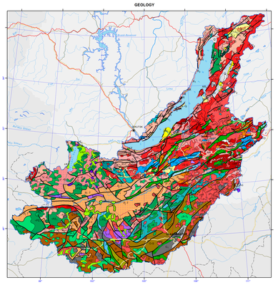
Geological structure</strong></strong></p>
<p align="center"><strong> </strong></p>
<p class="1" style="text-align: justify; ">
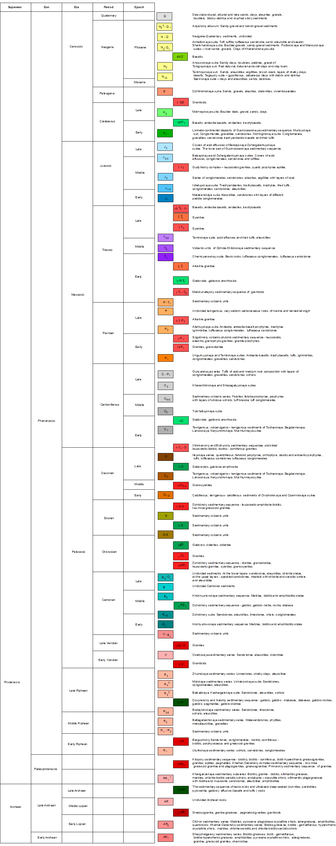
Many features inherent in the geological structure of the territory of the watershed basin are due to the fact that the territory lies at the interface between the two main lithospheric plates of East Siberia, namely the old Siberian platform, and the younger Central-Asian mobile belt. Formation of the geological structure of both Russian and Mongolian parts of the territory began in the Early Precambrian. For this reason, the geological structures, presented on the map, preserved traces of both Precambrian and Phanerozoic eras of tectogenesis.</p>
<p class="1" style="text-align: justify; ">Precambrian formations have been ascertained essentially within the mountain framing of the Baikal hollow and to the south and south-west of it, within the north-west of Mongolia.</p>
<p class="1" style="text-align: justify; ">The Precambrian sedimentary-metamorphic complexes within the mountain framing of the Baikal hollow, presumably of Archean age, are separated into three series differing in the set of rocks building them up, the degree of metamorphism, the type of magmatic manifestations, and the pattern of fold structures: the Sharyzhalgai, Khamar-Daban and Olkhon series. The occurrence area of rocks of the Sharyzhalgai series in the south is clearly delineated – it is a near-rectilinear shore of Lake Baikal between the source of the Angara river and the settlement of Kultuk, and in the south-west – by the zone of the Main Sayan Fault. Its composition includes rocks of two types: biotite, biotite-garnet and biotite-hypersthene migmatizated gneisses among which there occur, in the form of separate interlayers and thicker bedsets, amphibolites, pyroxene and amphibolite-pyroxene schists as well as granites differing in composition and structural-textural characteristics. The complex of sedimentary-metamorphic formations of the Khamar-Daban series is of widespread occurrence along the southern shores of Lake Baikal and within the confines of the Khamar-Daban mountain range. The composition of the series is notable for the Slyudyanka and Kharangul subseries. The Slyudyanka subseries is comprised of thick terrigenous-carbonate layers (carbonate bedsets, and specific silicious-dolomite apatite-bearing rocks), while the Kharangul subseries is dominated by flyschoid deposits (aluminous slates, and gneisses with rarely occurring interlayers and bedsets of carbonates). Deposits of the Olkhon series occur widely in Priolkhonie and on Olkhon Island; they are represented by marbles, pyroxene-plagioclase crystalline schists, amphibole-biotite gneisses, and magmatites with interbeds of amphibolites and quartzites. The Precambrian ophiolitic complex, confined to the suture zones of the fold belt, is registered in the north-western part of Mongolia.</p>
<p style="text-align: justify; ">The Lower-Proterozoic deposits of the Muya series are exposed on the watersheds of the Primorskii ridge along the coastal stripe of Maloe More and are represented by quartzites, slates and metamorphized effusives.</p>
<p style="text-align: justify; ">The Upper-Proterozoic (Riphean) deposits occur mainly within the Baikal mountain region. The Patom series occurs in the north of the region and divides into the Ballaganakh, Kadalikan and Bodaibo subseries which, in turn, subdivide into formations. In Western Cisbaikalia there occurs the Baikal series of the Upper Proterozoic consisting of three formations: the Goloustnoe, Uluntui and Kachergat formations. In the south, within the Olkha−Goloustnoe plateau there occur deposits of the Ushakovka formation of the Moty series.</p>
<p style="text-align: justify; ">Cambrian rocks occur widely in the Middle-Vitim, Angara-Barguzin, and Khamar-Daban mountain regions as well as in the mountain framing of Lake Khovsgol, and within the Uda river basin. The composition of Cambrian deposits is quite varied, ranging from conglomerates and sandstones to very fine carbonate differences. The Devonian deposits are represented by a rather broad spectrum of separate isolated areas; they are arbitrarily subdivided into two stratigraphic complexes. The lower Devonian layers are dominated by carbonate deposits, while the upper level is comprised of terrigenous and volcanogenic-terrigenous deposits. The Carboniferous deposits occur in many isolated areas.  The Carboniferous is represented largely by terrigenous marine deposits (sandstones, aleurites, gravelites, conglomerates, and slates). The Permian deposits are also extremely isolated. The largest field of Permian deposits is the Borzya deposit; it lies in Eastern Transbaikalia, and in Western Transbaikalia in the Khilok area. They are represented by relatively uniform terrigenous (and very rarely, carbonate) rocks of a marine and continental origin.</p>
<p style="text-align: justify; ">The Triassic deposits include widely occurring volcanogenic formations that are assigned to the Dzhida-Khilok series occurring with scouring on Paleozoic granitoids and other rocks. The lower layers are comprised of the Chernoyarovo formation consisting of major effusives, tuff conglomerates and tuff sandstones. The upper layers include the Tamirskaya formation consisting of acid effusives and their tuffs, and aleurites. Sedimentary and sedimentary-volcanic deposits of the Triassic occupy large areas in the western part of Mongolia, where they are interrupted in some places by the Jurassic sediments. The Lower-Jurassic formations are dominant in the eastern part of Transbaikalia, while marine deposits of the Lower- and partially Mid-Jurassic period are found only in the central part of Eastern Transbaikalia. In the north-west and south-east marine deposits are replaced by continental formations. Starting largely in the Mid-Jurassic period, the western and northern parts of Transbaikalia had been accumulating layers of conglomerates, sandstones, aleurites and argillites with interbeds of bituminous coal. The upper division includes covers of acid effusives. Such effusive-sedimentary formations also extend over the Vitim upland. The syncline cores, usually with their north-eastward strike line, occur in the area of Cretaceous freshwater-continental deposits. The lower part of these deposits refers to the Jurassic, while the upper part corresponds to the Cretaceous. The lower Cretaceous layers are comprised of conglomerates, sandstones, aleurites, slates and strata of brown coal, whereas the upper layers include boulder beds, shingle, sands and clays of the Mokheiskaya formation. In the central parts of Mongolia Cretaceous deposits are somewhat controlled spatially by deep faults and unconformably lie on the Devonian and Cambrian deposits.</p>
<p style="text-align: justify; ">Paleogene deposits occur very fragmentarily and are most commonly regarded as Upper Cretaceous−Paleogene deposits, because their detailed partition is unfeasible to date.  They are represented by covers of red and variegated-red clays, sandy-shingle deposits and lacustrine clays. Paleogene deposits are characterized by successive link of their composition with the laterite-kaolinite weathering crust. Miocene deposits of the Tankhoi formation are of widespread occurrence on the south-eastern shore of the lake; they were also found at different depths in the course of drilling in the sediments of the Ust-Selenginskaya depression, within the Barguzinskaya depression, and in intermountain depressions of Northern Pribaikalie. In the Dzhida mountainous area and on the Khamar-Daban range, basalt covers, overlaying the watershed areas, belong to the Miocene. On Olkhon Island, deposits of the Tagai formation, which are overlapped with an angular unconformity by deposits of the Sasinskaya formation (Upper Miocene - Lower Pliocene), are referred to the Lower-Middle Miocene. The Upper Pliocene and Eo-pleistocene in most cases compose a single rock mass, which resists dissection. Deposits of this age are registered in South Baikal (Shankhaikhinskaya formation), and in a number of areas of the eastern, western and southern surrounding of the Baikal hollow. On Olkhon Island the Upper Pliocene is represented by clays of the Kharantsy formation. Quaternary formations are characterized by a diversity of lithogenetic and facial types and occupy different geomorphological positions. Most often, the lower half of the profile of the quaternary system clearly shows a thick, complicated sandy layer, while the upper layers of the Pleistocene and Holocene are dominated by rudaceous deposits, including morainic.</p>
<p style="text-align: justify; ">The Siberian block of the Eurasian plate and adjoining spaces which, as a result of a long-lasting development, had transformed to the Sayan-Baikal orogenic belt, were characterized by the differing trends of geological events.</p>
<p style="text-align: justify; ">In the Early Precambrian, the sialic masses that merged together to form a single block, i.e. Siberia, comprised several Archean blocks with the well-developed continental crust. They were separated by proto-oceanic basins. Toward the end of the Early Proterozoic, the proto-continental blocks had formed a massif with a mature continental crust, i.e. a basement of the Siberian platform. As a result of the Early-Proterozoic orogeny, the marginal zone of the continent developed the mountain terrain which had been destroyed by the beginning of the Riphean. The Mid-Riphean stage started to accumulate the proper sedimentary cover of the Siberian platform. At the close of the Riphean−Vendian time, most of the paleocontinent was covered by the sea. On the other hand, orogenic movements resulted in the formation of elevated blocks of the Barguzin and Bokson−Khovsgol microcontinents. They produced a discontinuous chain of mountain ridges separating the Siberia paleocontinent from the Paleo-Asian Ocean. In the late Vendian−early Cambrian, the mountain massifs underwent substantial planation. Starting in the early Cambrian and during the Ordovician−Silurian, the eastern and southern margins of the basements of the microcontinents were represented by shelf zones, and by the upper parts of the continental slope of the oceanic basin. In the latter half of the early Paleozoic and at the beginning of the late Paleozoic, the collision of the Barguzin microcontinent with the Siberian platform triggered the formation of Barguzin granitoids. The latter half of the Paleozoic witnessed the collision of the Barguzin, Bokson-Khovsgol and other microcontinents with the margin of the Siberia paleocontinent. The Paleo-Asian Ocean stretched out southward of the Siberia paleocontinent. In the Hercynian era, the active processes in the Mongol−Okhotsk belt were responsible for the tectonic-magmatic intensification of the Sayan-Baikal region and the southern part of the Siberian platform. At the beginning of the Mesozoic, an attenuation of the vertical tectonic movements led to peneplanation with the formation of a thick weathering crust. The subsequent Mesozoic intensification was responsible for a growth of the mountains in the Sayan-Baikal region, and for an intensification of intrusive magmatism.</p>
<p style="text-align: justify; ">The end of the Cretaceous−Paleogene was marked by a long-lasting period of peneplanation and crust formation which preceded directly the Cenozoic riftogenesis and the formation of the morphostructural plan of the Baikal Rift Zone and the Baikal basin.</p>
<p style="text-align: justify; ">The distinguished tectonic stages are very clearly registered in three tectonic blocks in the territory of Mongolia, namely: western – Caledonian; central – Early Caledonian, with numerous outthrusts of rocks of the crystalline basement and Hercynian and Mesozoic structures overlaying them, and southern – Hercynian. In general, the modern overlapped-folded structure of the Mongolian territory outlines certain spatial and temporal patterns, consisting in a directional change of more ancient structures, located in the north and west, by younger ones, clearly manifested in the south.</p>
<p style="text-align: justify; ">
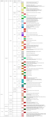
The territory of the the Baikal basin is unique as regards the occurrence, range and diversity of granitoids, which occupy more than 70% of the area, while the formation of acid magmas was taking place from the Archean to the early Cretaceous. They tend to occur within the Mongol−Okhotsk (Mongol-Transbaikalian) mobile belt, having a complex long-lasting history. The following stages of magmatism are identified:</p>
<p style="text-align: justify; ">1. Archean early-orogenic – formation of migmatites and lenticular concordant bodies of gneissogranites and granites. Archean late-orogenic – intrusive bodies of pink and red leucocratic significantly potassic granites and alaskites.</p>
<p style="text-align: justify; ">2. Early Proterozoic late-orogenic fissure intrusions of the seaside granite complex.</p>
<p style="text-align: justify; ">3. Late Baikalian−early Caledonian (Vendian−early Cambrian) – basic volcanism, ultrabasic intrusions.</p>
<p style="text-align: justify; ">4. Late Caledonian (Cambrian−Silurian) – formation of granitoids on a mass scale.</p>
<p style="text-align: justify; ">5. Early Hercynian (Devonian) – local occurrence of acid and mixed volcanism. Intrusions of alkali-earth syenites, granites, and alaskite granites.</p>
<p style="text-align: justify; ">6. Late Hercynian (Carboniferous−Permian) – intrusive series of gabbro-monzonite-syenite, alkali-syenite and alkali-granite composition.</p>
<p style="text-align: justify; "><a href="http://dic.academic.ru/dic.nsf/ruwiki/1261431">7. Triassic−Cretaceous</a> – series of tectono-magma activations with the establishment of volcano-tectonic structures, formation of intrusions of normal and alkali-earth granodiorite−leucogranite series and effusion of basaltoids.</p>
<p style="text-align: justify; ">8. Quaternary period – riftogenesis and effusion of alkali basaltoids.</p>]]></content:encoded>
    <dc:publisher>No publisher</dc:publisher>
    <dc:creator>Alexander Ayurzhanaev</dc:creator>
    <dc:rights></dc:rights>
    <dc:date>2014-10-07T02:00:00Z</dc:date>
    <dc:type>Page</dc:type>
  </item>


</rdf:RDF>
