<?xml version="1.0" encoding="utf-8" ?>
<rdf:RDF xmlns:rdf="http://www.w3.org/1999/02/22-rdf-syntax-ns#" xmlns:dc="http://purl.org/dc/elements/1.1/" xmlns:syn="http://purl.org/rss/1.0/modules/syndication/" xmlns="http://purl.org/rss/1.0/">


<channel rdf:about="http://bic.iwlearn.org/en/search_rss">
  <title>English</title>
  <link>http://bic.iwlearn.org</link>

  <description>
    
            These are the search results for the query, showing results 281 to 295.
        
  </description>


  <image rdf:resource="http://bic.iwlearn.org/logo.png"/>

  <items>
    <rdf:Seq>
      
        <rdf:li rdf:resource="http://bic.iwlearn.org/en/atlas/atlas/42-landscape-stability-map"/>
      
      
        <rdf:li rdf:resource="http://bic.iwlearn.org/en/atlas/atlas/45-main-types-of-non-metallic-materials-map"/>
      
      
        <rdf:li rdf:resource="http://bic.iwlearn.org/en/atlas/atlas/41-physiographic-regionalization-map"/>
      
      
        <rdf:li rdf:resource="http://bic.iwlearn.org/en/atlas/atlas/82-tourism-map/tourism-map"/>
      
      
        <rdf:li rdf:resource="http://bic.iwlearn.org/en/atlas/atlas/03-lake-baikal-basin-borders-and-structure-map"/>
      
      
        <rdf:li rdf:resource="http://bic.iwlearn.org/en/atlas/atlas/09-steepness-of-slopes-map"/>
      
      
        <rdf:li rdf:resource="http://bic.iwlearn.org/en/atlas/atlas/08-relief-map"/>
      
      
        <rdf:li rdf:resource="http://bic.iwlearn.org/en/atlas/atlas/07-seismic-risk-zoning-map"/>
      
      
        <rdf:li rdf:resource="http://bic.iwlearn.org/en/atlas/atlas/06-geology-map"/>
      
      
        <rdf:li rdf:resource="http://bic.iwlearn.org/en/atlas/atlas/11-orographic-scheme-of-lake-baikal-basin-map"/>
      
      
        <rdf:li rdf:resource="http://bic.iwlearn.org/en/atlas/atlas/05-administrative-territorial-system-map"/>
      
      
        <rdf:li rdf:resource="http://bic.iwlearn.org/en/atlas/atlas/01-satellite-image-map"/>
      
      
        <rdf:li rdf:resource="http://bic.iwlearn.org/en/atlas/atlas/10-geomorphology-map"/>
      
      
        <rdf:li rdf:resource="http://bic.iwlearn.org/en/atlas/atlas/04-hypsographic-map"/>
      
      
        <rdf:li rdf:resource="http://bic.iwlearn.org/en/atlas/atlas/04-hypsographic-map/copy_of_04-hypsographic-map"/>
      
    </rdf:Seq>
  </items>

</channel>


  <item rdf:about="http://bic.iwlearn.org/en/atlas/atlas/42-landscape-stability-map">
    <title>042. Landscape stability map</title>
    <link>http://bic.iwlearn.org/en/atlas/atlas/42-landscape-stability-map</link>
    <description></description>
    
    <dc:publisher>No publisher</dc:publisher>
    <dc:creator>Alexander Ayurzhanaev</dc:creator>
    <dc:rights></dc:rights>
    <dc:date>2014-10-07T01:40:00Z</dc:date>
    <dc:type>Folder</dc:type>
  </item>


  <item rdf:about="http://bic.iwlearn.org/en/atlas/atlas/45-main-types-of-non-metallic-materials-map">
    <title>045. Main types of non-metallic materials map</title>
    <link>http://bic.iwlearn.org/en/atlas/atlas/45-main-types-of-non-metallic-materials-map</link>
    <description></description>
    
    <dc:publisher>No publisher</dc:publisher>
    <dc:creator>Alexander Ayurzhanaev</dc:creator>
    <dc:rights></dc:rights>
    <dc:date>2014-10-07T01:40:00Z</dc:date>
    <dc:type>Folder</dc:type>
  </item>


  <item rdf:about="http://bic.iwlearn.org/en/atlas/atlas/41-physiographic-regionalization-map">
    <title>041. Physiographic regionalization map</title>
    <link>http://bic.iwlearn.org/en/atlas/atlas/41-physiographic-regionalization-map</link>
    <description></description>
    
    <dc:publisher>No publisher</dc:publisher>
    <dc:creator>Alexander Ayurzhanaev</dc:creator>
    <dc:rights></dc:rights>
    <dc:date>2014-10-07T01:40:00Z</dc:date>
    <dc:type>Folder</dc:type>
  </item>


  <item rdf:about="http://bic.iwlearn.org/en/atlas/atlas/82-tourism-map/tourism-map">
    <title>Tourism map</title>
    <link>http://bic.iwlearn.org/en/atlas/atlas/82-tourism-map/tourism-map</link>
    <description></description>
    <content:encoded xmlns:content="http://purl.org/rss/1.0/modules/content/"><![CDATA[<p><img class="image-inline" src="../../../resolveuid/b05baa84669049b9888661f593b652bd/@@images/image/preview" /></p>
<p><a href="http://bic.iwlearn.org/en/atlas/photos/copy_of__82_Tourism.png" class="internal-link">Open full size</a></p>
<p align="center"><strong>Tourism</strong></p>
<p align="center"><strong> </strong></p>
<p>The Baikal basin is a unique area that draws attention of tourists from all over the world. Its location in the heart of the Eurasian landmass has defined its high ethno-cultural and natural diversity. The history of development of the lands around Baikal is connected with the rise of two giant empires – Mongolian and Russian, as well as with the historical development of trade and transport routes.</p>
<p>
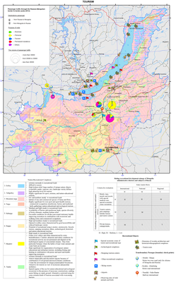
The natural and resource nucleus of the recreational system of the Baikal basin is the oldest and deepest lake in the world itself. Infrastructural centers for tourism development are major cities of Ulaanbaatar, Irkutsk, and Ulan-Ude. They play the role of major international transport hubs and have administrative, educational, and cultural tourism resources, as well as a significant hospitality potential. In 2012, Ulaanbaatar had the largest hotel fund (over 170 hotels). There were about 80 hotels in Irkutsk and up to 20 in Ulan-Ude. In general, the transboundary area of the Baikal basin has over a thousand places for tourist accommodation of general and special purpose (Fig. 1).</p>
<p style="text-align: center; "><img class="image-inline" src="../../../resolveuid/e1da5a0a1de942da8b51036648fbd2bb/@@images/image/preview" /></p>
<ul>
<li>
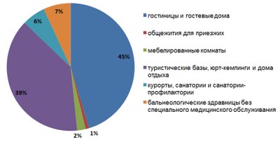
hotels and guest houses </li>
<li>hostel for visitors </li>
<li>hostels, yurt camping and rest houses </li>
<li>resorts, motels and sanatorium </li>
<li>balneologic resorts without special health care</li>
</ul>
<p style="text-align: justify; "><b>Figure 1. Recreational accommodation facilities in the transboundary Baikal basin [Business of the Angara region…, 2012; Activities of tourism firms..., 2011; Culture, tourism, and recreation…, 2012; Tourism in Sunny Buryatia, 2011; Soyol ..., 2013]</b></p>
<p>The number of accommodation facilities, as well as the level of offered services in conjunction with the configuration and nature of the tourist traffic help identify the most important areas for the tourism industry, assess the degree of tourism development, and get a general picture of a territorial structure of recreational activities. A matrix integrating the character of tourist traffic and a predominant type of accommodation was used as the basis for the expert assessment of tourism development of administrative units of Russia and Mongolia.</p>
<p>
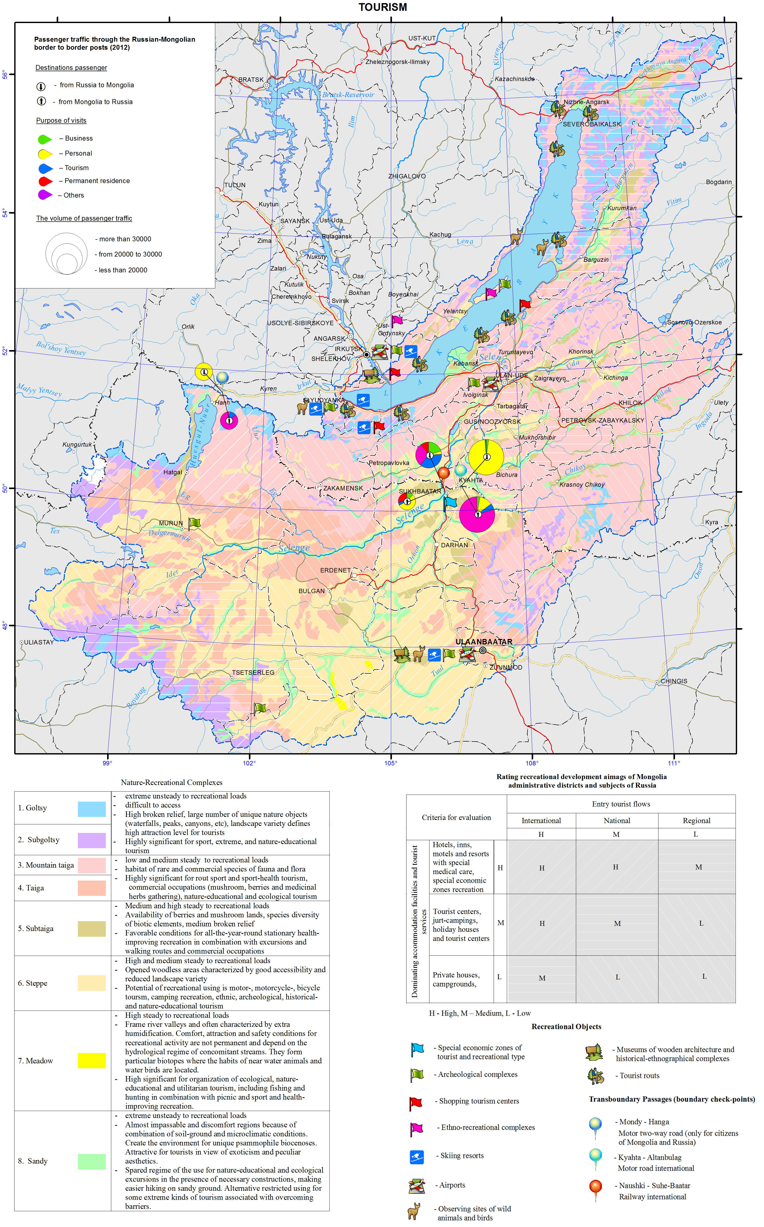
The main distinctive characteristics of the recreational system of the Baikal basin is its transboundary position. Therefore, the neighboring aimags of Mongolia and administrative districts of Irkutsk oblast and the Republic of Buryatia that are located along the state border and have cross-border corridors (ports of entry) are of a special significance.</p>
<p>The process of development of cross-border tourism in the neighboring territories of Russia and Mongolia is taking place under conditions, where both countries with a unique culture and nature are an integral part of the international recreational space, have a special interest for tourists from other countries, and make mutual contribution to the formation of the inbound tourist traffic. The Russian-Mongolian border, which crosses the basin, has three checkpoints that not only facilitate the exchange of foreign and domestic tour groups, but also serve as a prerequisite for the development of cross-border trade. Within 10 years, the total volume of passenger traffic through the existing checkpoints has more than doubled – from 229 thousand people in 2002 to 502.5 thousand people in 2012 (Fig. 2).
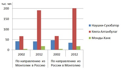
</p>
<p style="text-align: center; "><img class="image-inline" src="../../../resolveuid/1c774d490c45475d9df1908773c75d9d/@@images/image/preview" /></p>
<p align="center"> </p>
<ul>
<li>Naushki-Sükhbaatar</li>
<li>Kyakhta-Altabulag</li>
<li>Mondy-Khankh</li>
</ul>
<p style="text-align: justify; "><b>Figure 2. Passenger traffic through the Russian-Mongolian border [Mongolian..., 2013; Mongolian ..., 2006]</b></p>
<p>Development of cross-border tourism requires joint decisions to promote a common tourism product on the state level. Such projects as “Baikal-Khovsgol”, which connects two great lakes of Asia, and “The Tea Road” have already become popular. The establishment of transboundary special protected areas have great prospects for the bilateral cooperation in the field of eco-tourism. They represent a particular organizational resource, which is important not only for the resolution of shared environmental problems, but also for the coordination of efforts aimed at implementing cross-border tourism projects.</p>
<p>Active cooperation between Russia and Mongolia in promoting tourism within the unique natural object – the Baikal basin not only opens the possibilities for increasing inbound foreign tourism in both countries, but also contributes to the expansion of similar relationships with other neighboring countries, such as China, Kazakhstan, and Japan.</p>
<p> </p>
<p align="center">References</p>
<p>Statistical Compendium. (2012). <i>Business of the Angara region: Tourism and hospitality</i>. Irkutsk: Irkutskstat. p 35-62.</p>
<p>Statistical Compendium. (2011). <i>Activities of tourism firms and collective accommodation facilities in the Republic of Buryatia in 2011</i>. Ulan-Ude: Buryatstat. p 7-12.</p>
<p>Statistical Compendium. (2012). <i>Culture, tourism, and recreation in the Angara region</i>. Irkutsk: Irkutskstat. p 45-52.</p>
<p>Statistical Compendium. (2011). <i>Tourism in Sunny Buryatia</i>. Ulan-Ude: Buryatstat. p 59.</p>
<p>National Statistical Office of Mongolia. (2013). <i>Soyol, sport, ayalal, zhuulchlalyn salbaryn lavlakh</i>. Ulaanbaatar. p 285.</p>
<p>National Statistical Office of Mongolia. (2012). <i>Mongolian statistical yearbook 2012</i>. Ulaanbaatar. p 297-299.</p>
<p>National Statistical Office of Mongolia. (2007). <i>Mongolian statistical yearbook 2006</i>. Ulaanbaatar. p 265-269.</p>]]></content:encoded>
    <dc:publisher>No publisher</dc:publisher>
    <dc:creator>Alexander Ayurzhanaev</dc:creator>
    <dc:rights></dc:rights>
    <dc:date>2014-10-07T00:56:13Z</dc:date>
    <dc:type>Page</dc:type>
  </item>


  <item rdf:about="http://bic.iwlearn.org/en/atlas/atlas/03-lake-baikal-basin-borders-and-structure-map">
    <title>003. Lake Baikal basin borders and structure map</title>
    <link>http://bic.iwlearn.org/en/atlas/atlas/03-lake-baikal-basin-borders-and-structure-map</link>
    <description></description>
    
    <dc:publisher>No publisher</dc:publisher>
    <dc:creator>Alexander Ayurzhanaev</dc:creator>
    <dc:rights></dc:rights>
    <dc:date>2014-10-07T00:05:00Z</dc:date>
    <dc:type>Folder</dc:type>
  </item>


  <item rdf:about="http://bic.iwlearn.org/en/atlas/atlas/09-steepness-of-slopes-map">
    <title>009. Steepness of slopes map</title>
    <link>http://bic.iwlearn.org/en/atlas/atlas/09-steepness-of-slopes-map</link>
    <description></description>
    
    <dc:publisher>No publisher</dc:publisher>
    <dc:creator>Alexander Ayurzhanaev</dc:creator>
    <dc:rights></dc:rights>
    <dc:date>2014-10-07T00:01:52Z</dc:date>
    <dc:type>Folder</dc:type>
  </item>


  <item rdf:about="http://bic.iwlearn.org/en/atlas/atlas/08-relief-map">
    <title>008. Relief map</title>
    <link>http://bic.iwlearn.org/en/atlas/atlas/08-relief-map</link>
    <description></description>
    
    <dc:publisher>No publisher</dc:publisher>
    <dc:creator>Alexander Ayurzhanaev</dc:creator>
    <dc:rights></dc:rights>
    <dc:date>2014-10-07T00:01:51Z</dc:date>
    <dc:type>Folder</dc:type>
  </item>


  <item rdf:about="http://bic.iwlearn.org/en/atlas/atlas/07-seismic-risk-zoning-map">
    <title>007. Seismic risk zoning map</title>
    <link>http://bic.iwlearn.org/en/atlas/atlas/07-seismic-risk-zoning-map</link>
    <description></description>
    
    <dc:publisher>No publisher</dc:publisher>
    <dc:creator>Alexander Ayurzhanaev</dc:creator>
    <dc:rights></dc:rights>
    <dc:date>2014-10-07T00:01:51Z</dc:date>
    <dc:type>Folder</dc:type>
  </item>


  <item rdf:about="http://bic.iwlearn.org/en/atlas/atlas/06-geology-map">
    <title>006. Geology map</title>
    <link>http://bic.iwlearn.org/en/atlas/atlas/06-geology-map</link>
    <description></description>
    
    <dc:publisher>No publisher</dc:publisher>
    <dc:creator>Alexander Ayurzhanaev</dc:creator>
    <dc:rights></dc:rights>
    <dc:date>2014-10-07T00:01:51Z</dc:date>
    <dc:type>Folder</dc:type>
  </item>


  <item rdf:about="http://bic.iwlearn.org/en/atlas/atlas/11-orographic-scheme-of-lake-baikal-basin-map">
    <title>011. Orographic scheme of Lake Baikal basin map</title>
    <link>http://bic.iwlearn.org/en/atlas/atlas/11-orographic-scheme-of-lake-baikal-basin-map</link>
    <description></description>
    
    <dc:publisher>No publisher</dc:publisher>
    <dc:creator>Alexander Ayurzhanaev</dc:creator>
    <dc:rights></dc:rights>
    <dc:date>2014-10-07T00:01:52Z</dc:date>
    <dc:type>Folder</dc:type>
  </item>


  <item rdf:about="http://bic.iwlearn.org/en/atlas/atlas/05-administrative-territorial-system-map">
    <title>005. Administrative-territorial system map</title>
    <link>http://bic.iwlearn.org/en/atlas/atlas/05-administrative-territorial-system-map</link>
    <description></description>
    
    <dc:publisher>No publisher</dc:publisher>
    <dc:creator>Alexander Ayurzhanaev</dc:creator>
    <dc:rights></dc:rights>
    <dc:date>2014-10-07T00:01:51Z</dc:date>
    <dc:type>Folder</dc:type>
  </item>


  <item rdf:about="http://bic.iwlearn.org/en/atlas/atlas/01-satellite-image-map">
    <title>001. Satellite image map</title>
    <link>http://bic.iwlearn.org/en/atlas/atlas/01-satellite-image-map</link>
    <description></description>
    
    <dc:publisher>No publisher</dc:publisher>
    <dc:creator>Alexander Ayurzhanaev</dc:creator>
    <dc:rights></dc:rights>
    <dc:date>2014-10-07T00:01:50Z</dc:date>
    <dc:type>Folder</dc:type>
  </item>


  <item rdf:about="http://bic.iwlearn.org/en/atlas/atlas/10-geomorphology-map">
    <title>010. Geomorphology map</title>
    <link>http://bic.iwlearn.org/en/atlas/atlas/10-geomorphology-map</link>
    <description></description>
    
    <dc:publisher>No publisher</dc:publisher>
    <dc:creator>Alexander Ayurzhanaev</dc:creator>
    <dc:rights></dc:rights>
    <dc:date>2014-10-07T00:01:52Z</dc:date>
    <dc:type>Folder</dc:type>
  </item>


  <item rdf:about="http://bic.iwlearn.org/en/atlas/atlas/04-hypsographic-map">
    <title>004. Hypsographic map</title>
    <link>http://bic.iwlearn.org/en/atlas/atlas/04-hypsographic-map</link>
    <description></description>
    
    <dc:publisher>No publisher</dc:publisher>
    <dc:creator>Alexander Ayurzhanaev</dc:creator>
    <dc:rights></dc:rights>
    <dc:date>2014-10-07T00:01:51Z</dc:date>
    <dc:type>Folder</dc:type>
  </item>


  <item rdf:about="http://bic.iwlearn.org/en/atlas/atlas/04-hypsographic-map/copy_of_04-hypsographic-map">
    <title>004. Hypsographic map</title>
    <link>http://bic.iwlearn.org/en/atlas/atlas/04-hypsographic-map/copy_of_04-hypsographic-map</link>
    <description></description>
    <content:encoded xmlns:content="http://purl.org/rss/1.0/modules/content/"><![CDATA[<p style="text-align: center; "><img class="image-inline" src="../../../resolveuid/8ed5e9a0dc524916a23701382d2c32ad/@@images/image/preview" /></p>
<p><a href="http://bic.iwlearn.org/en/atlas/photos/copy_of__04_Hypsographic.png" class="internal-link">Open full size</a></p>
<p class="a" style="text-align: justify; ">Patterns of territorial combinations of conditions and factors of the development of environmental problems in the Baikal basin are, to a large extent, determined by the basin’s location in the northern temperate latitudes of Eurasia, in its inner ultracontinental sector, and by its natural isolation from adjacent territories. The Baikal basin has all the features of the landscape and ecological integrity and economic and cultural unity. The region is home to one of the world's major watershed divides between the catchment areas of the Arctic Ocean (the Yenisei and Lena basins), Pacific Ocean (the Amur basin), and the drainless region of Central Asia. It is precisely here, on orographic barriers, where airflows from the Atlantic and Pacific Oceans, the Arctic, and southern territories subside.</p>
<p class="a" style="text-align: justify; ">Lake Baikal is the oldest, deepest, and largest by volume lake among the great rift lakes of the world. The lake is situated at an elevation of 455.5 meters above sea level, between 51°28’ - 55°47’N and 103°43’ - 109°58’E. The Baikal basin's catchment area is located in the heart of Asia on the territory of two states – Russia and Mongolia - between 46°20’ - 56°40’N and 96°50’ - 114°10’E. It has an elongated shape stretching from southwest to northeast. The total area of the Baikal basin is 576.5 sq. km, including the water area of Lake Baikal - 31.7 sq. km. 44.6 % of the catchment area is located in the Russian Federation (31.8 % in the Republic of Buryatia, 10.2 % in Zabaikalsky krai, 2.2 % in Irkutsk oblast, and 0.4 % in the Republic of Tuva) and 55.4 % in Mongolia. About 53 % of the volume of river water is formed in Buryatia, 27 % in Mongolia, 16 % in Zabaikalsky krai, and 4 % in Irkutsk oblast.</p>
<p style="text-align: justify; ">In general, due to its geographical and geopolitical location, as well as natural, resource, economic, ethnic, cultural, and human resources potential and the lake itself, the Baikal basin represents a key strategic region in eastern Russia and northern Mongolia - a major foothold for social and economic development of the two countries. However, such development has its own peculiarities, because the Baikal basin has a special regime of natural resources management. The fact that Lake Baikal and its surrounding territory was listed as a UNESCO World Heritage Site has attracted attention of the global community. It also underlined the role of the great lake as both a unique natural phenomenon and a place for establishing a recreation zone of the planetary significance, as well as a source of the exclusively eco-oriented land management and business in the future. Over the long term, in the context of the growing deficit of freshwater in the world, Lake Baikal’s water will become the most important strategic resource of the world. Therefore, the water factor of development is a priority. Reproduction and recovery of the lake’s water take place on the territory of the whole Baikal basin, which predetermines a particular attention towards nature protection in this region and dictates the prohibition of numerous types of production in order to prevent environmental pollution and preserve the Baikal water for humankind. Presently, the necessity of nature protection activities for maintaining the unmatched biological and landscape diversity of the lake's basin has emerged as a result of the intensive use of natural resources in different parts of the basin, where anthropogenic impact of varying degree and type is observed. Only responsible use of the complex of adaptive techniques and methods of organization of economic activity with due consideration to the special environmental and resource-related role and strategic importance of the Baikal region can make it, as early as in the first third of the 21st century, one of the full-fledged subjects of economic, geopolitical, and geo-demographic processes and relations of global significance. The Ecological Atlas of the Baikal Basin will be quite helpful in this endeavor. For the first time ever, the maps of this Atlas will reflect spatial patterns of the development of the environmental situation within the whole catchment basin of Lake Baikal and its water area, which makes it possible to define and substantiate the directions of environmentally balanced and sustainable territorial development of Russia and Mongolia in the future.</p>]]></content:encoded>
    <dc:publisher>No publisher</dc:publisher>
    <dc:creator>Alexander Ayurzhanaev</dc:creator>
    <dc:rights></dc:rights>
    <dc:date>2014-10-06T05:05:00Z</dc:date>
    <dc:type>Page</dc:type>
  </item>


</rdf:RDF>
