
<?xml version="1.0" encoding="utf-8" ?>
<rdf:RDF xmlns:rdf="http://www.w3.org/1999/02/22-rdf-syntax-ns#" xmlns:dc="http://purl.org/dc/elements/1.1/" xmlns:syn="http://purl.org/rss/1.0/modules/syndication/" xmlns="http://purl.org/rss/1.0/">


<channel rdf:about="http://bic.iwlearn.org/en/search_rss">
  <title>English</title>
  <link>http://bic.iwlearn.org</link>

  <description>
    
            These are the search results for the query, showing results 175 to 189.
        
  </description>


  <image rdf:resource="http://bic.iwlearn.org/logo.png"/>

  <items>
    <rdf:Seq>
      
        <rdf:li rdf:resource="http://bic.iwlearn.org/en/friends/mongolian-environmental-citizen2019s-council-mongolia"/>
      
      
        <rdf:li rdf:resource="http://bic.iwlearn.org/en/friends/mongolian"/>
      
      
        <rdf:li rdf:resource="http://bic.iwlearn.org/en/friends/mongolian/mongolian"/>
      
      
        <rdf:li rdf:resource="http://bic.iwlearn.org/en/friends/mongolia-water-forum-ngo-mongolia"/>
      
      
        <rdf:li rdf:resource="http://bic.iwlearn.org/en/news/the-baikal-project/58ef7c7d791fe489d7c7c1fa5260b33a"/>
      
      
        <rdf:li rdf:resource="http://bic.iwlearn.org/en/atlas/atlas/27-minimum-summer-runoff-map/minimum-summer-runoff-map"/>
      
      
        <rdf:li rdf:resource="http://bic.iwlearn.org/en/atlas/atlas/48-mineral-waters-map/mineral-waters-map"/>
      
      
        <rdf:li rdf:resource="http://bic.iwlearn.org/en/documents/documents/papers/mercury-exposure-in-female-artisanal-small-scale-gold-miners-asgm-in-mongolia-english"/>
      
      
        <rdf:li rdf:resource="http://bic.iwlearn.org/en/atlas/atlas/99-medical-service-density-nursing-staff-map/medical-service-density-nursing-staff-map"/>
      
      
        <rdf:li rdf:resource="http://bic.iwlearn.org/en/atlas/atlas/98-medical-service-density-doctors-map/medical-service-density-doctors-map"/>
      
      
        <rdf:li rdf:resource="http://bic.iwlearn.org/en/atlas/atlas/28-maximum-runoff-during-the-flood-map/maximum-runoff-during-the-flood-map"/>
      
      
        <rdf:li rdf:resource="http://bic.iwlearn.org/en/photos/map_baikalbasin"/>
      
      
        <rdf:li rdf:resource="http://bic.iwlearn.org/en/atlas/atlas/108-malignant-neoplasms-map/malignant-neoplasms-map"/>
      
      
        <rdf:li rdf:resource="http://bic.iwlearn.org/en/atlas/atlas/45-main-types-of-non-metallic-materials-map/main-types-of-non-metallic-materials-map"/>
      
      
        <rdf:li rdf:resource="http://bic.iwlearn.org/en/friends/local-environmental-public-organization-turka-russia-buryat-republic"/>
      
    </rdf:Seq>
  </items>

</channel>


  <item rdf:about="http://bic.iwlearn.org/en/friends/mongolian-environmental-citizen2019s-council-mongolia">
    <title>Mongolian environmental citizen’s council (Mongolia)</title>
    <link>http://bic.iwlearn.org/en/friends/mongolian-environmental-citizen2019s-council-mongolia</link>
    <description></description>
    <content:encoded xmlns:content="http://purl.org/rss/1.0/modules/content/"><![CDATA[<p style="text-align: center; "><b>MONGOLIAN ENVIRONMENTAL CITIZEN’S COUNCIL</b></p>
<p style="text-align: center; "><b><img class="image-inline" src="../../resolveuid/74c7a117f99a4f6c8a9ad7ff4822f5df/@@images/image/preview" /></b></p>
<p><span style="text-decoration: underline;">Contact details: </span></p>
<p>Room 310, Freshwater center Building , Zaisan tolgoi, 11<sup>th</sup> khoroo, Khan-Uul district, Ulaanbaatar, Mongolia</p>
<p>Phone/Fax+976 70131400</p>
<p>Website/e-mail <a href="http://www.mecc.mn/">http://www.mecc.mn</a> <a href="mailto:irgenii.zuwlul@gmail.com">irgenii.zuwlul@gmail.com</a></p>
<p><span style="text-decoration: underline;">Year of Establishment </span>2008<span style="text-decoration: underline;"></span></p>
<p>Head of the organization Mr. Damdinsuren S.</p>
<p><span style="text-decoration: underline;">Scope of the activities</span> Conservation and protection of Mongolia’s environment and the nature<span style="text-decoration: underline;"></span></p>
<p><span style="text-decoration: underline;">Mission/Objectives</span> Better coordination of Mongolian NGO’s committed to environmental conservation<span style="text-decoration: underline;"></span></p>
<p><span style="text-decoration: underline;">List of the environmental related projects implemented/or participated during last 3-4 years.</span></p>
<p>-         Number of trainings on environmental conservation is organized for its member NGO’s</p>
<p>-         Series of debates and consultations on enforcement of mining related laws and seminars among members</p>
<p><span style="text-decoration: underline;">Major results</span><span style="text-decoration: underline;"></span></p>
<p>-         Better organized NGO involvements into decision making process</p>
<p>-         Powerful voices against improper use of natural resources especially in mining sector.</p>
<p>Well informed members and more skilled members</p>
<p style="text-align: center; "><img class="image-inline" src="../../resolveuid/80bdb3e0eed84784b188c1641f030011/@@images/image/preview" /></p>
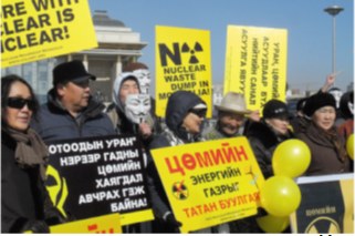
<p style="text-align: center; ">Environmental Citizen Council. Protesting debates on  nucleur wastes<img class="image-inline" src="../../resolveuid/47f075b7417f45f99e6efaa9e7ff3b92/@@images/image/preview" /></p>
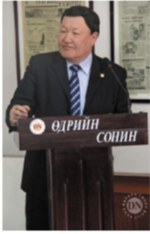
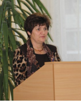
<p style="text-align: center; ">Head of the organization Mr. Damdinsuren S.</p>]]></content:encoded>
    <dc:publisher>No publisher</dc:publisher>
    <dc:creator>Alexander Ayurzhanaev</dc:creator>
    <dc:rights></dc:rights>
    <dc:date>2015-02-09T02:47:47Z</dc:date>
    <dc:type>Page</dc:type>
  </item>


  <item rdf:about="http://bic.iwlearn.org/en/friends/mongolian">
    <title>Mongolian</title>
    <link>http://bic.iwlearn.org/en/friends/mongolian</link>
    <description></description>
    
    <dc:publisher>No publisher</dc:publisher>
    <dc:creator>Dmitry Popov</dc:creator>
    <dc:rights></dc:rights>
    <dc:date>2014-02-06T10:59:42Z</dc:date>
    <dc:type>Folder</dc:type>
  </item>


  <item rdf:about="http://bic.iwlearn.org/en/friends/mongolian/mongolian">
    <title>Mongolian</title>
    <link>http://bic.iwlearn.org/en/friends/mongolian/mongolian</link>
    <description> </description>
    <content:encoded xmlns:content="http://purl.org/rss/1.0/modules/content/"><![CDATA[<ol>
<li>Монгольская ассоциация по сохранению природы и окружающей среды (MACNE)</li>
<li>Федерация женщин Монголии</li>
<li>Движение зелёных Монголии (ДЗМ)</li>
<li>Монгольский консорциум природы и окружающей среды (MNEC)</li>
<li>Союз природоохранных НПО Монголии (UMENGO)</li>
<li>Национальное общество окружающей среды Монголии</li>
<li>Общество экологического образования </li>
<li>Ассоциация женщин-экологов</li>
<li>Всемирный фонд дикой природы (WWF), монгольское отделение</li>
</ol>
<p>10.  Монгольская водная ассоциация</p>
<p>11.  Монгольское национальное общество экотуризма (MNETS)</p>
<p>12.  Монгольская национальная горнодобывающая ассоциация</p>
<p>13.  «Центр сохранения традиций» на базе некоммерческой оргнизации «Центр экологической информации»</p>
<p>14.  Фонд защиты животный</p>
<p>15.  «Мундуухей»</p>
<p>16.  Чистая природа</p>
<p>17.  Арвайские степи Баянтолгой</p>
<p>18.  Баян намаг – зелёный сад</p>
<p>19.  Бурханская земля</p>
<p>20.  Сэнжитейский залив</p>
<p>21.  Движение «Онги река» Сэнжитейский залив</p>
<p>22.  Движение «Салхин сандаг»</p>
<p>23.  Движение «Тосон заамар-тулл река»</p>
<p>24.  Фонд «Хан-алтай»</p>
<p>25.  Земля Хубсугула</p>
<p>26.  Река «Худэр»</p>
<p>27.  Зов гор и рек</p>
<p>28.  Волна чёрных озёр</p>
<p>29.  Общественная организация коренных народов</p>
<p>30.  Объединённое движение рек и озёр Монголии</p>]]></content:encoded>
    <dc:publisher>No publisher</dc:publisher>
    <dc:creator>Dmitry Popov</dc:creator>
    <dc:rights></dc:rights>
    <dc:date>2014-03-18T08:41:10Z</dc:date>
    <dc:type>Page</dc:type>
  </item>


  <item rdf:about="http://bic.iwlearn.org/en/friends/mongolia-water-forum-ngo-mongolia">
    <title>Mongolia water forum NGO (Mongolia)</title>
    <link>http://bic.iwlearn.org/en/friends/mongolia-water-forum-ngo-mongolia</link>
    <description></description>
    <content:encoded xmlns:content="http://purl.org/rss/1.0/modules/content/"><![CDATA[<p align="center"><b>MONGOLIA WATER FORUM NGO</b></p>
<p> </p>
<p><span style="text-decoration: underline;">Contact details:</span> (976) 8808-1839, (976) 8808-1839</p>
<p>Website/e-mail <a href="mailto:info@mongoliawaterforum.com">info@mongoliawaterforum.com</a></p>
<p><a href="http://www.mongoliawaterforum.com/">www.mongoliawaterforum.com</a></p>
<p><span style="text-decoration: underline;">Year of Establishment </span>2012</p>
<p><span style="text-decoration: underline;">Head of the organization</span> Ms. Batimaa Punsalmaa</p>
<p><span style="text-decoration: underline;">Scope of the activities</span></p>
<p>-         Water, environmental research</p>
<p>-         Advocacy and public awareness activities</p>
<p>-         Trainings, workshops and seminars on water and environmental issues</p>
<p><span style="text-decoration: underline;">Mission</span> Support sustainable utilization and conservation of water resources</p>
<p><span style="text-decoration: underline;">List of the environmental related projects implemented</span></p>
<p>Main activities implemented during 2012-2014: <span style="text-decoration: underline;"></span></p>
<p align="left">Study reports: Socio-economic  and ecological baseline study in Khuvsgol lake, Eg river and Ider river basins; Socio-economic baseline study for Kharkhiraa river and Turgen river basins; Socio-economic and ecological baseline study for river catchments of Yeroo, Khuder and Minj rivers; Water quality study in Kharaa river River-basin management plans for: Khuvsgol lake and Eg river<b>, </b>Ider river<b>, </b>Yeroo, Khuder and Minj rivers<b></b></p>
<p>Major results</p>
<p>- Conducted studies on number of major river catchments in Mongolia</p>
<p>- Number of debates and public consultations on integrated river basin management</p>
<p>- At least 3 management plans of major rivers in northern Mongolia is developed and submitted for approval</p>
<p>Number of reports on national water standard, sanitation.</p>]]></content:encoded>
    <dc:publisher>No publisher</dc:publisher>
    <dc:creator>Alexander Ayurzhanaev</dc:creator>
    <dc:rights></dc:rights>
    <dc:date>2015-02-09T02:43:41Z</dc:date>
    <dc:type>Page</dc:type>
  </item>


  <item rdf:about="http://bic.iwlearn.org/en/news/the-baikal-project/58ef7c7d791fe489d7c7c1fa5260b33a">
    <title>Model Database</title>
    <link>http://bic.iwlearn.org/en/news/the-baikal-project/58ef7c7d791fe489d7c7c1fa5260b33a</link>
    <description>Database for modeling and simulation of pollutants transport in the Baikal basin waters.</description>
    <content:encoded xmlns:content="http://purl.org/rss/1.0/modules/content/"><![CDATA[<p>Executors: Moscow State University, Baikal Institute of Nature Management (Russian Academy of Sciences). End of works: December 15, 2012.</p>
<p>Final products:</p>
<ul>
<li>Complex geoinformation system “the Selenga basin, based on ARCGIS software compatible with attributive data base”.</li>
<li>Measured pollution content in the Selenga basin rivers within historical data.</li>
<li>Set of maps of actual condition (pollution content) of the Selenga basin river system within the observation period (literature references) and according to the data of Moscow State University 2011-2012 expeditions (maps of water run-off characteristics, suspended and tractional loads, chemical elements in the Selenga basin).</li>
</ul>
<p>The work completed. ARCGIS data base has been developed and presented to the Project management bureau.</p>
<p><a class="internal-link" href="http://baikal.iwlearn.org/en/project/project-tender-reports-2012/011-database-for-modeling">Download the Final Report (RUS)</a></p>]]></content:encoded>
    <dc:publisher>No publisher</dc:publisher>
    <dc:creator>Sergey Kudelya</dc:creator>
    <dc:rights></dc:rights>
    <dc:date>2013-03-02T08:05:28Z</dc:date>
    <dc:type>Feed Item</dc:type>
  </item>


  <item rdf:about="http://bic.iwlearn.org/en/atlas/atlas/27-minimum-summer-runoff-map/minimum-summer-runoff-map">
    <title>Minimum summer runoff map</title>
    <link>http://bic.iwlearn.org/en/atlas/atlas/27-minimum-summer-runoff-map/minimum-summer-runoff-map</link>
    <description></description>
    <content:encoded xmlns:content="http://purl.org/rss/1.0/modules/content/"><![CDATA[<p><img class="image-inline" src="../../../resolveuid/4b69f3ed34cf465b9efd7b5d76fb36f5/@@images/image/preview" /></p>
<p><a href="http://bic.iwlearn.org/en/atlas/photos/copy_of__27_Minimumsummerrunoff.png" class="internal-link">Open full size</a></p>
<p align="center"><strong>Flow</strong></p>
<p>The map “Mean annual flow” reflects the formation patterns of the water regime of the territory, which are determined by the properties of landscapes to transform atmospheric moisture into the runoff.</p>
<p>For a water body basin, the surface runoff is the total amount of water loss from the watershed landscapes. The runoff rate from landscape complexes is determined by solving the inverse problem, i.e. identification of the connection of flow rate at the main stream station of a catchment with the runoff from landscapes, occupying its area, and is calculated based on the equation Q<sub>j</sub> = ∑q<sub>i</sub> f<sub>ij</sub><i>,</i><i> </i>where <i>j</i> is the index of the river basin, Q<sub>j</sub> is its runoff, L/s; q<sub>i</sub> is a modification of flow from the i-th landscape complex, L/s km<sup>2</sup>; f<sub>ij</sub> is an area of the j-th basin occupied by the i-th landscape, km<sup>2</sup>. Long-term average runoff data for small and medium-sized rivers of theLake Baikal basin were used in calculations for the map construction [Long-term…, 1986, http://www.r-arcticnet.sr.unh.edu]. Characteristics of landscape components were obtained on the basis of the materials on landscape of the Baikal region [Landscapes…, 1977, Natural..., 2009, Landscapes…, 1990, Lysanova et al., 2009]. In accordance with the regional dimension, generalization degree is chosen at the geom level, and their average annual flow moduli are determined. The territory on the map is divided into regions according to five gradations of the module - from less than 1 to more than 10 L/s km<sup>2</sup>.</p>
<p>The catchment area of the lake covers a variety of landscape zones and altitudinal belts, which makes a great contrast between the runoff rates. The highest annual flow moduli are formed within the goletz and mountain-taiga landscapes. Steppe and forest-steppe areas are distinguished by the minimum runoff rates, and in the desert regions of Mongolia (the Selenga river basin) flow formation almost does not take place.</p>
<p>The maps of minimum and maximum flow were compiled based on the typological landscape classification represented on the map [Landscapes…, 1977]. In the course of investigation, landscapes of different types were generalized by identifying the most hydrologically informative properties (morphological characteristics, vegetation structure, altitudinal zonation, etc.). As a result, more than 200 landscapes were combined into sixteen types of natural complexes, and runoff rates were determined for them. The moduli of maximum snow runoff and minimum summer runoff were calculated as described above.</p>
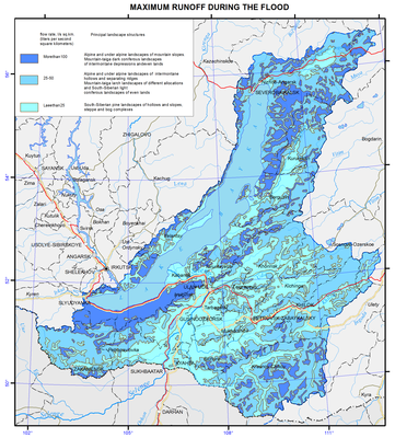
<p>Areas with the highest runoff of floods are confined to the mountain ranges and systems with goletz open woodlands and mountain-taiga landscapes. The main areas, distinguished by formation of frequent and high floods are the Baikalsky Range on the north-eastern end of the lake; Barguzinsky Range, located in the south-eastern part of the catchment, and the Khamar-Daban, covering the south-western shore of Lake Baikal. The values of the maximum flow modification are shown in three gradations on the map, namely: less than 25, 25-70, and more than 100 L/s km<sup>2</sup>.</p>
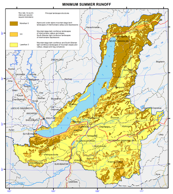
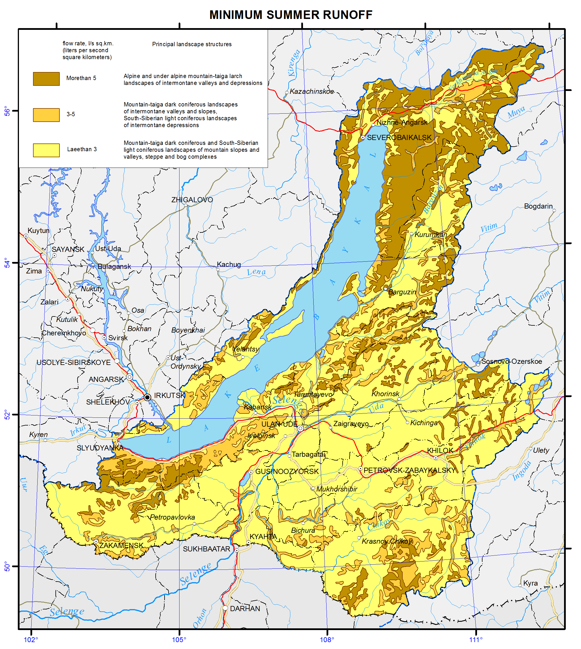
<p>Features of formation of the minimum summer runoff in the Baikal basin are associated with the regime of atmospheric moisture, as well as with the effects of altitude and exposition. The calculations and analysis of the minimum summer runoff have shown a relatively high water yield in the low-flow period from high-mountain taiga landscapes and extremely low river flow formation in the central areas of the Selenga river catchment and in Priolkhonie, which are covered with light coniferous landscapes and steppe complexes on slopes and plains. The map shows the value of the minimum flow in three gradations, namely: less than 1.5, 3.0-5.0, and more than 5.0 L/s km<sup>2</sup>.</p>
<p>Landscape-hydrological mapping based on the quantitative characteristics of water yield of landscape complexes objectively reflects the hydrological organization of the territory.</p>
<p><b> </b></p>
<p align="center">References</p>
<p>Kuznetsova T.I. (2009). Map "Natural landscapes of the Baikal region and their use: purpose, structure, and content”.  T.I. Kuznetsova, A.R. Batuev, and A.V. Bardash. <i>Geodeziya i kartografiya,</i> , no 9, pp. 18-28.</p>
<p>Landscapes of southern East Siberia [Maps]: [physical map] (1977) / compiled and prep. for printing by factory no. 4 GUGK in 1976, authors: V.S. Mikheev and V.A. Ryashin. 1: 1 500 000, Moscow: GUGK, 1 map (4 sheets): col.</p>
<p>Landscapes [Maps] [physical map] / The National Atlas of the Mongolian People's Republic. / comp .and prep to print by GUGK in 1989, authors: B.M. Ishmuratov, K.N. Misevich, I.L. Savelyeva, et al.</p>
<p>Lysanova, G.I., Semenov, Yu.M., Shekhovtsov, A.I., and Sorokovoy, A.A. (2013). Geosystems of the Republic of Tuva. <i>Geografiya i prirodnye resursy</i>, no. 3, pp. 181-185.</p>
<p>Long-term data on the regime and surface water resources. The Baikal basin. (1986). Vol. 1, no. 14, Leningrad: Gidrometeoizdat, 361 p.</p>
<p><b><i>A Regional, Electronic, Hydrographic Data Network For the Arctic Region.</i></b> <b>URL: </b><a href="http://www.r-arcticnet.sr.unh.edu/"><b>http://www.r-arcticnet.sr.unh.edu</b></a></p>]]></content:encoded>
    <dc:publisher>No publisher</dc:publisher>
    <dc:creator>Alexander Ayurzhanaev</dc:creator>
    <dc:rights></dc:rights>
    <dc:date>2014-10-07T02:55:00Z</dc:date>
    <dc:type>Page</dc:type>
  </item>


  <item rdf:about="http://bic.iwlearn.org/en/atlas/atlas/48-mineral-waters-map/mineral-waters-map">
    <title>Mineral waters map</title>
    <link>http://bic.iwlearn.org/en/atlas/atlas/48-mineral-waters-map/mineral-waters-map</link>
    <description></description>
    <content:encoded xmlns:content="http://purl.org/rss/1.0/modules/content/"><![CDATA[<p><img class="image-inline" src="../../../resolveuid/c6afd68e36b64110bdddd43d637b238c/@@images/image/preview" /></p>
<p><a href="http://bic.iwlearn.org/en/atlas/photos/copy_of__48_Mineralwaters.png" class="internal-link">Open full size</a></p>
<p align="center"><strong>Mineral springs</strong></p>
<p align="center"><strong> </strong></p>
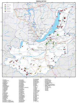
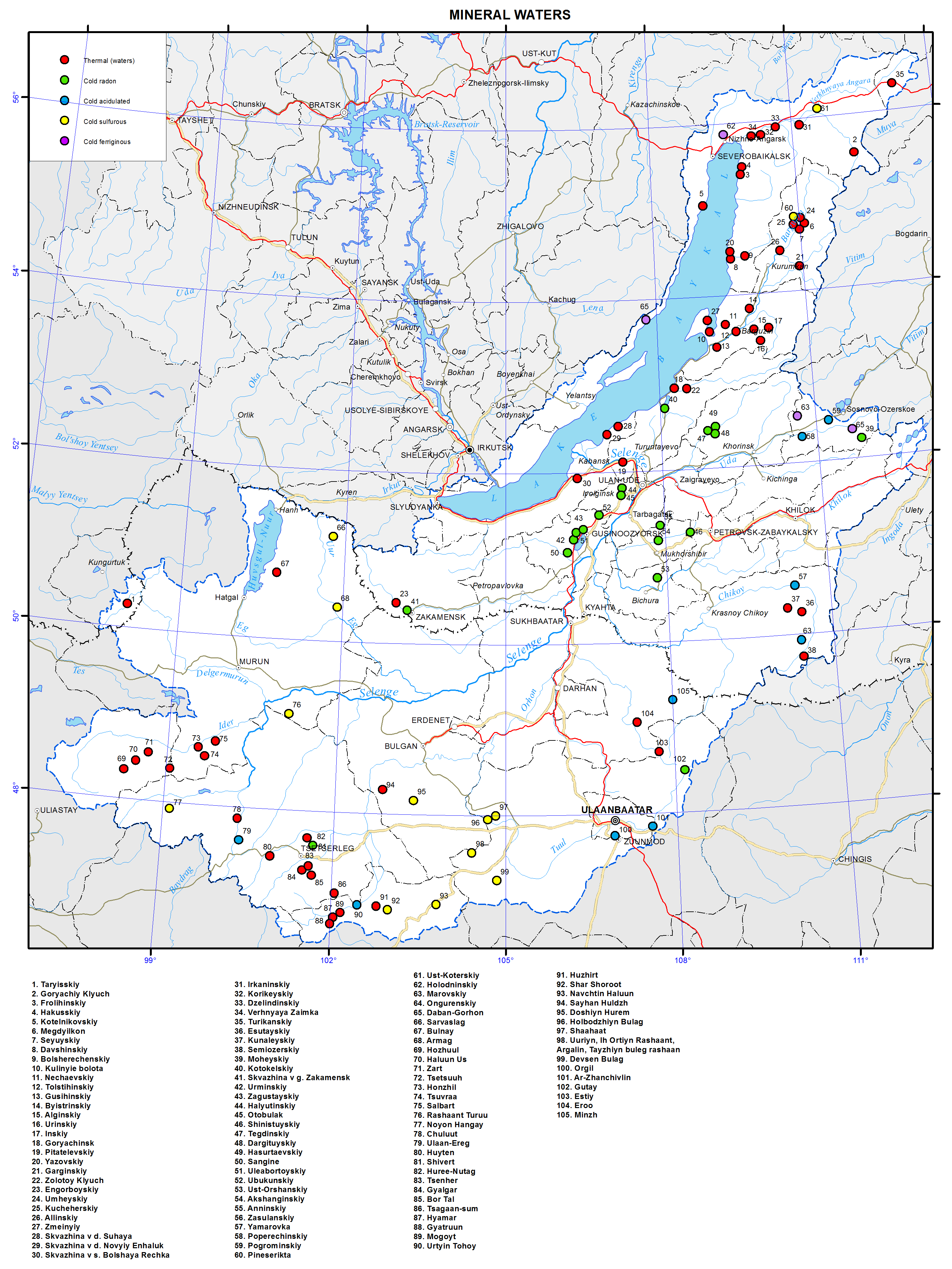
<p>The map is based on generalizing monographs, maps of mineral waters and field research data obtained by the authors.</p>
<p>The map depicts mineral springs, the water of which can be used for balneological purposes according to its physical and chemical properties. These characteristics include: water temperature (hot springs); radon content (cold radon springs), content of free carbon dioxide (carbonic cold springs), content of sulphate sulfur (cold hydrogen sulfide springs) and iron (ferrous cold springs).</p>
<p>This map can be used for the organization of sanatorium-and-spa construction, as well as for planning of underground thermal water use in thermal engineering.<b> </b></p>
<p align="center">References</p>
<p>Borisenko, I.M., Zamana, L. (1978). <i>Mineral water of Buryatia</i>. - Ulan-Ude: Buryat kn. izd-vo. - 163 p.</p>
<p>Map of the Republic of Tyva (tourism objects, objects of nature, arzhaans, photos).(2012). - M1:1000000, Kyzyl.</p>
<p>Lomonosov, I.S., Kustov, Yu.I., Pinneker, E.V. (1977). <i>Mineral water in Baikal region</i>. – Irkutsk: Vost. Sib . kn. izd-vo. - 224 p.</p>
<p><i>Mineral water of southern part of Eastern Siberia.</i> Vol.II. (1962) – M.-L.: Izd. AN USSR. - 199 p.</p>
<p>Pissarsky, B.I., Nambar, B, Ariyadagva, B. (2003). <i>Map of mineral waters in Mongolia</i>. 1:2500000, - Ulaanbaatar.</p>]]></content:encoded>
    <dc:publisher>No publisher</dc:publisher>
    <dc:creator>Alexander Ayurzhanaev</dc:creator>
    <dc:rights></dc:rights>
    <dc:date>2014-10-08T05:50:00Z</dc:date>
    <dc:type>Page</dc:type>
  </item>


  <item rdf:about="http://bic.iwlearn.org/en/documents/documents/papers/mercury-exposure-in-female-artisanal-small-scale-gold-miners-asgm-in-mongolia-english">
    <title>Mercury exposure in female artisanal small-scale gold miners (ASGM) in Mongolia (English)</title>
    <link>http://bic.iwlearn.org/en/documents/documents/papers/mercury-exposure-in-female-artisanal-small-scale-gold-miners-asgm-in-mongolia-english</link>
    <description></description>
    
    <dc:publisher>No publisher</dc:publisher>
    <dc:creator>puntsagsurenchoimpog@yahoo.com</dc:creator>
    <dc:rights></dc:rights>
    <dc:date>2014-12-30T01:28:11Z</dc:date>
    <dc:type>File</dc:type>
  </item>


  <item rdf:about="http://bic.iwlearn.org/en/atlas/atlas/99-medical-service-density-nursing-staff-map/medical-service-density-nursing-staff-map">
    <title>Medical service density - Nursing staff map</title>
    <link>http://bic.iwlearn.org/en/atlas/atlas/99-medical-service-density-nursing-staff-map/medical-service-density-nursing-staff-map</link>
    <description></description>
    <content:encoded xmlns:content="http://purl.org/rss/1.0/modules/content/"><![CDATA[<p><img class="image-inline" src="../../../resolveuid/c581f72dfaff4a92abe0d96a88b48956/@@images/image/preview" /></p>
<p><a href="http://bic.iwlearn.org/en/atlas/photos/copy_of__99_MedicalservicedensityNursingstaff.png" class="internal-link">Open full size</a></p>
<p align="center"><strong>Healthcare</strong><strong> </strong></p>
<p align="center"><strong> </strong></p>
<p>Harsh climatic conditions across the entire territory of the Baikal basin and the surface and ground water used for drinking and food purposes that do not meet the drinking water quality standards (first and foremost in Mongolia and Buryatia) coupled with atmospheric emissions from industrial facilities and motor vehicles (in some parts of the territory) are responsible for the state of human health influencing the organization of healthcare. The ecological situation becomes substantially worse during winter months, which is encouraged by the topography of the terrain. In Mongolia, the spring period is very hard time to bear, with sharp temperature differences, abrupt variations in atmospheric pressure, and frequent dust and magnetic storms.</p>
<p class="NormalWeb">The organizational pattern of healthcare in Russia and Mongolia has much in common. This is a result of the cooperation of the two countries in this sphere and the fact that medical education and healthcare in Mongolia are organized using Russian experience. Today, Mongolian medical facilities operate on the principles of the state-private partnership concurrent with the demonopolization of the state system of medical services. The country has a mandatory and voluntary medical insurance system, in which state-owned and private medical institutions take part. The country also has various health institutes and centers.</p>
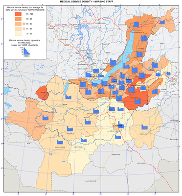
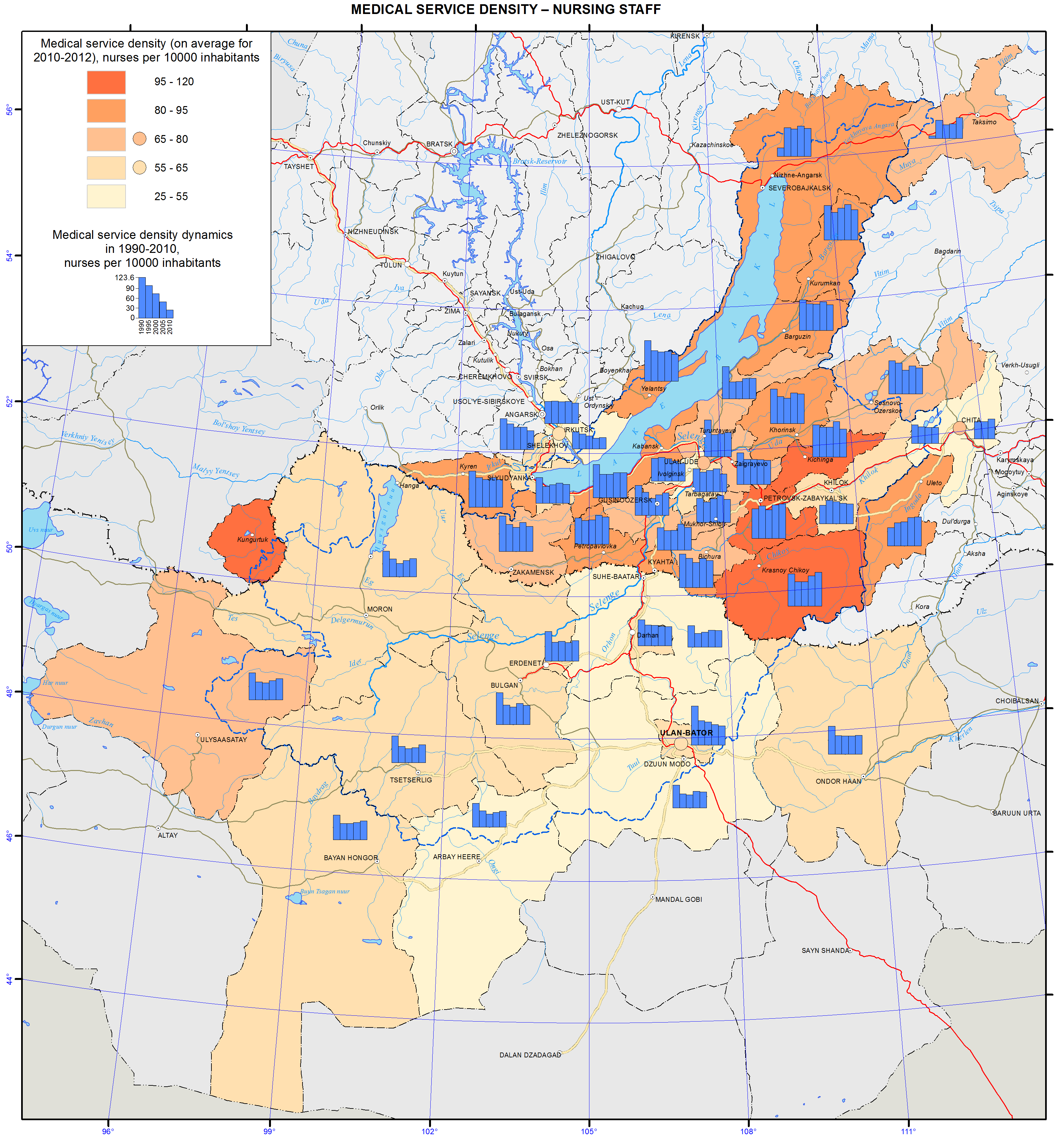
<p class="a">The territory of the Baikal basin is experiencing a deficit of medical workers. As of 2012, the availability of physicians varied from 13.8 to 30.1 per 10,000 people in Russian districts and from 16.1 to 29.0 per 10,000 people in Mongolian aimags. The availability of nurses varies from 25.1 to 112.2 per 10,000 people in Russian districts and from 26.4 to 38.2 per 10,000 people in Mongolian aimags. In Ulan-Ude, these indicators have the values of 53.9 and 117.3, while in Ulaanbaatar – 44.1 and 41.2, respectively.</p>
<p>The ratio of doctors and nurses in the Russian part of the basin is between 1:2 to 1:4, while in the Mongolian part it does not exceed 1:2. The World Health Organization (WHO) recommends that this ratio should be 1:4. A narrowing of this indicator causes imbalances in the healthcare system thereby limiting possibilities for further development of the after-treatment, casework and rehabilitation services.</p>
<p>Target indicators of healthcare activity are the standard volume of medical care per inhabitant. Currently, there are plans to decrease the per capita volume of in-patient services and increase the per capita volume of the hospital-replacing care. Accordingly, the number of hospital beds available 27/7 will decrease, while the number of beds in day hospitals will grow. Overall, the available number of hospital beds complies with the calculated standards and meets the demand of the population for the in-patient medical aid.</p>
<p class="ConsPlusNormal">As of today, in Russia, there is an array of problems relating to the high level of illnesses and disability incidences among the population, and these indicators are continuously growing. Such a situation is the result of inadequate preventive measures. Another important contributing factor to this situation is the increase of the proportion of elderly population and the improved effectiveness of illness detection using new diagnostic methods in the process of the increased number of medical checkups.</p>
<p class="ConsPlusNormal">The leading illnesses in the structure of morbidity are respiratory illnesses, bloodstream, eye, and digestive and musculoskeletal system diseases, as well as traumas. For many years, circulatory system diseases, neoplasms, and injuries have been the main causes of mortality and disability among the population.</p>
<p class="a">A complex of anthropogenic environmental factors contributes to the growth of morbidity and disability rates among the population with the most important one being air pollution. According to the WHO, atmospheric air pollution is the cause of up to 23% of all illnesses. The amount of pollutant emissions in the atmosphere produced by static sources in different administrative divisions in the Baikal basin differs by more than a thousand times. The most polluted air in the Baikal basin is in the Selenginsky district of Buryatia.</p>
<p>The health of the population and further development of healthcare depend on ecological, social, and economic factors. These problems can be resolved only through comprehensive approaches to the improvement of the quality of life of the population.</p>
<p>The strategic goal of the healthcare systems of Russia and Mongolia is to build a system, which ensures the quality and accessibility of medical services, primarily first aid, and increases the efficiency of medical services, based on the improvement of territorial planning of healthcare. The volume, types, and quality of these services should correspond to the rate of morbidity, population requirements, and the latest achievements of medical science, based on perfecting the system of territorial planning of public health services.</p>]]></content:encoded>
    <dc:publisher>No publisher</dc:publisher>
    <dc:creator>Alexander Ayurzhanaev</dc:creator>
    <dc:rights></dc:rights>
    <dc:date>2014-10-13T06:15:00Z</dc:date>
    <dc:type>Page</dc:type>
  </item>


  <item rdf:about="http://bic.iwlearn.org/en/atlas/atlas/98-medical-service-density-doctors-map/medical-service-density-doctors-map">
    <title>Medical service density - Doctors map</title>
    <link>http://bic.iwlearn.org/en/atlas/atlas/98-medical-service-density-doctors-map/medical-service-density-doctors-map</link>
    <description></description>
    <content:encoded xmlns:content="http://purl.org/rss/1.0/modules/content/"><![CDATA[<p><img class="image-inline" src="../../../resolveuid/639ff5082bd24d74bbb798a5ee9123f1/@@images/image/preview" /></p>
<p><a href="http://bic.iwlearn.org/en/atlas/photos/copy_of__98_MedicalservicedensityDoctors.png" class="internal-link">Open full size</a></p>
<p align="center"><strong>Healthcare</strong><strong> </strong></p>
<p align="center"><strong> </strong></p>
<p>Harsh climatic conditions across the entire territory of the Baikal basin and the surface and ground water used for drinking and food purposes that do not meet the drinking water quality standards (first and foremost in Mongolia and Buryatia) coupled with atmospheric emissions from industrial facilities and motor vehicles (in some parts of the territory) are responsible for the state of human health influencing the organization of healthcare. The ecological situation becomes substantially worse during winter months, which is encouraged by the topography of the terrain. In Mongolia, the spring period is very hard time to bear, with sharp temperature differences, abrupt variations in atmospheric pressure, and frequent dust and magnetic storms.</p>
<p class="NormalWeb">The organizational pattern of healthcare in Russia and Mongolia has much in common. This is a result of the cooperation of the two countries in this sphere and the fact that medical education and healthcare in Mongolia are organized using Russian experience. Today, Mongolian medical facilities operate on the principles of the state-private partnership concurrent with the demonopolization of the state system of medical services. The country has a mandatory and voluntary medical insurance system, in which state-owned and private medical institutions take part. The country also has various health institutes and centers.</p>
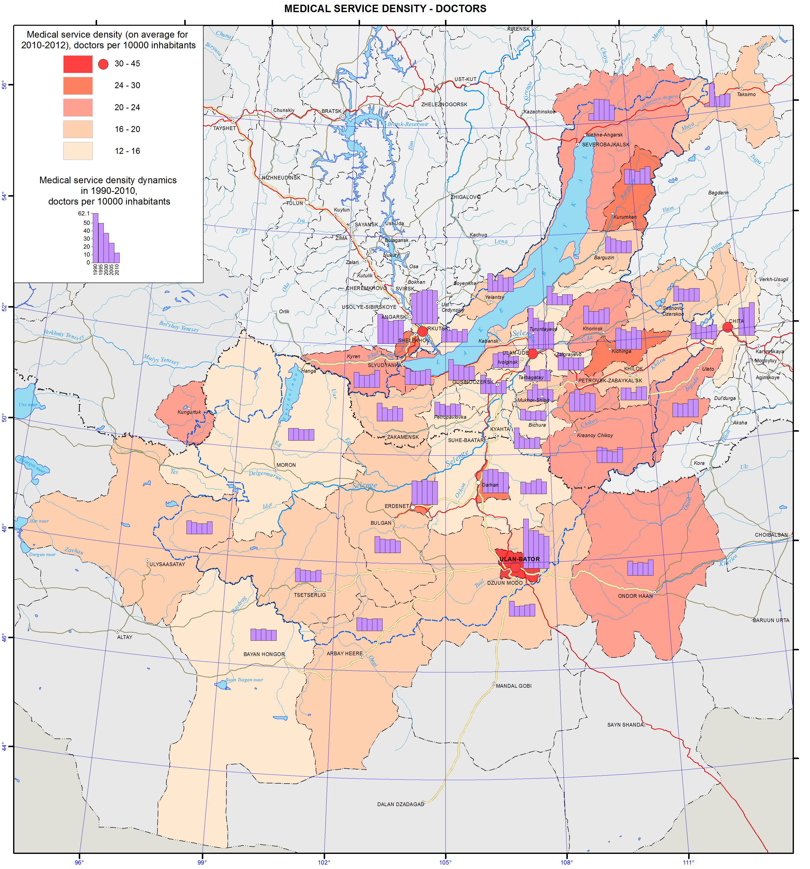
<p class="a">The territory of the Baikal basin is experiencing a deficit of medical workers. As of 2012, the availability of physicians varied from 13.8 to 30.1 per 10,000 people in Russian districts and from 16.1 to 29.0 per 10,000 people in Mongolian aimags. The availability of nurses varies from 25.1 to 112.2 per 10,000 people in Russian districts and from 26.4 to 38.2 per 10,000 people in Mongolian aimags. In Ulan-Ude, these indicators have the values of 53.9 and 117.3, while in Ulaanbaatar – 44.1 and 41.2, respectively.</p>
<p>The ratio of doctors and nurses in the Russian part of the basin is between 1:2 to 1:4, while in the Mongolian part it does not exceed 1:2. The World Health Organization (WHO) recommends that this ratio should be 1:4. A narrowing of this indicator causes imbalances in the healthcare system thereby limiting possibilities for further development of the after-treatment, casework and rehabilitation services.</p>
<p>Target indicators of healthcare activity are the standard volume of medical care per inhabitant. Currently, there are plans to decrease the per capita volume of in-patient services and increase the per capita volume of the hospital-replacing care. Accordingly, the number of hospital beds available 27/7 will decrease, while the number of beds in day hospitals will grow. Overall, the available number of hospital beds complies with the calculated standards and meets the demand of the population for the in-patient medical aid.</p>
<p class="ConsPlusNormal">As of today, in Russia, there is an array of problems relating to the high level of illnesses and disability incidences among the population, and these indicators are continuously growing. Such a situation is the result of inadequate preventive measures. Another important contributing factor to this situation is the increase of the proportion of elderly population and the improved effectiveness of illness detection using new diagnostic methods in the process of the increased number of medical checkups.</p>
<p class="ConsPlusNormal">The leading illnesses in the structure of morbidity are respiratory illnesses, bloodstream, eye, and digestive and musculoskeletal system diseases, as well as traumas. For many years, circulatory system diseases, neoplasms, and injuries have been the main causes of mortality and disability among the population.</p>
<p class="a">A complex of anthropogenic environmental factors contributes to the growth of morbidity and disability rates among the population with the most important one being air pollution. According to the WHO, atmospheric air pollution is the cause of up to 23% of all illnesses. The amount of pollutant emissions in the atmosphere produced by static sources in different administrative divisions in the Baikal basin differs by more than a thousand times. The most polluted air in the Baikal basin is in the Selenginsky district of Buryatia.</p>
<p>The health of the population and further development of healthcare depend on ecological, social, and economic factors. These problems can be resolved only through comprehensive approaches to the improvement of the quality of life of the population.</p>
<p>The strategic goal of the healthcare systems of Russia and Mongolia is to build a system, which ensures the quality and accessibility of medical services, primarily first aid, and increases the efficiency of medical services, based on the improvement of territorial planning of healthcare. The volume, types, and quality of these services should correspond to the rate of morbidity, population requirements, and the latest achievements of medical science, based on perfecting the system of territorial planning of public health services.</p>]]></content:encoded>
    <dc:publisher>No publisher</dc:publisher>
    <dc:creator>Alexander Ayurzhanaev</dc:creator>
    <dc:rights></dc:rights>
    <dc:date>2014-10-13T06:05:00Z</dc:date>
    <dc:type>Page</dc:type>
  </item>


  <item rdf:about="http://bic.iwlearn.org/en/atlas/atlas/28-maximum-runoff-during-the-flood-map/maximum-runoff-during-the-flood-map">
    <title>Maximum runoff during the flood map</title>
    <link>http://bic.iwlearn.org/en/atlas/atlas/28-maximum-runoff-during-the-flood-map/maximum-runoff-during-the-flood-map</link>
    <description></description>
    <content:encoded xmlns:content="http://purl.org/rss/1.0/modules/content/"><![CDATA[<p><img class="image-inline" src="../../../resolveuid/7e21331f5819408badfa79e4240cb100/@@images/image/preview" /></p>
<p><a href="http://bic.iwlearn.org/en/atlas/photos/copy_of__28_Maximumrunoffduringtheflood.png" class="internal-link">Open full size</a></p>
<p align="center"><strong>Flow</strong></p>
<p>The map “Mean annual flow” reflects the formation patterns of the water regime of the territory, which are determined by the properties of landscapes to transform atmospheric moisture into the runoff.</p>
<p>For a water body basin, the surface runoff is the total amount of water loss from the watershed landscapes. The runoff rate from landscape complexes is determined by solving the inverse problem, i.e. identification of the connection of flow rate at the main stream station of a catchment with the runoff from landscapes, occupying its area, and is calculated based on the equation Q<sub>j</sub> = ∑q<sub>i</sub> f<sub>ij</sub><i>,</i><i> </i>where <i>j</i> is the index of the river basin, Q<sub>j</sub> is its runoff, L/s; q<sub>i</sub> is a modification of flow from the i-th landscape complex, L/s km<sup>2</sup>; f<sub>ij</sub> is an area of the j-th basin occupied by the i-th landscape, km<sup>2</sup>. Long-term average runoff data for small and medium-sized rivers of theLake Baikal basin were used in calculations for the map construction [Long-term…, 1986, http://www.r-arcticnet.sr.unh.edu]. Characteristics of landscape components were obtained on the basis of the materials on landscape of the Baikal region [Landscapes…, 1977, Natural..., 2009, Landscapes…, 1990, Lysanova et al., 2009]. In accordance with the regional dimension, generalization degree is chosen at the geom level, and their average annual flow moduli are determined. The territory on the map is divided into regions according to five gradations of the module - from less than 1 to more than 10 L/s km<sup>2</sup>.</p>
<p>The catchment area of the lake covers a variety of landscape zones and altitudinal belts, which makes a great contrast between the runoff rates. The highest annual flow moduli are formed within the goletz and mountain-taiga landscapes. Steppe and forest-steppe areas are distinguished by the minimum runoff rates, and in the desert regions of Mongolia (the Selenga river basin) flow formation almost does not take place.</p>
<p>The maps of minimum and maximum flow were compiled based on the typological landscape classification represented on the map [Landscapes…, 1977]. In the course of investigation, landscapes of different types were generalized by identifying the most hydrologically informative properties (morphological characteristics, vegetation structure, altitudinal zonation, etc.). As a result, more than 200 landscapes were combined into sixteen types of natural complexes, and runoff rates were determined for them. The moduli of maximum snow runoff and minimum summer runoff were calculated as described above.</p>
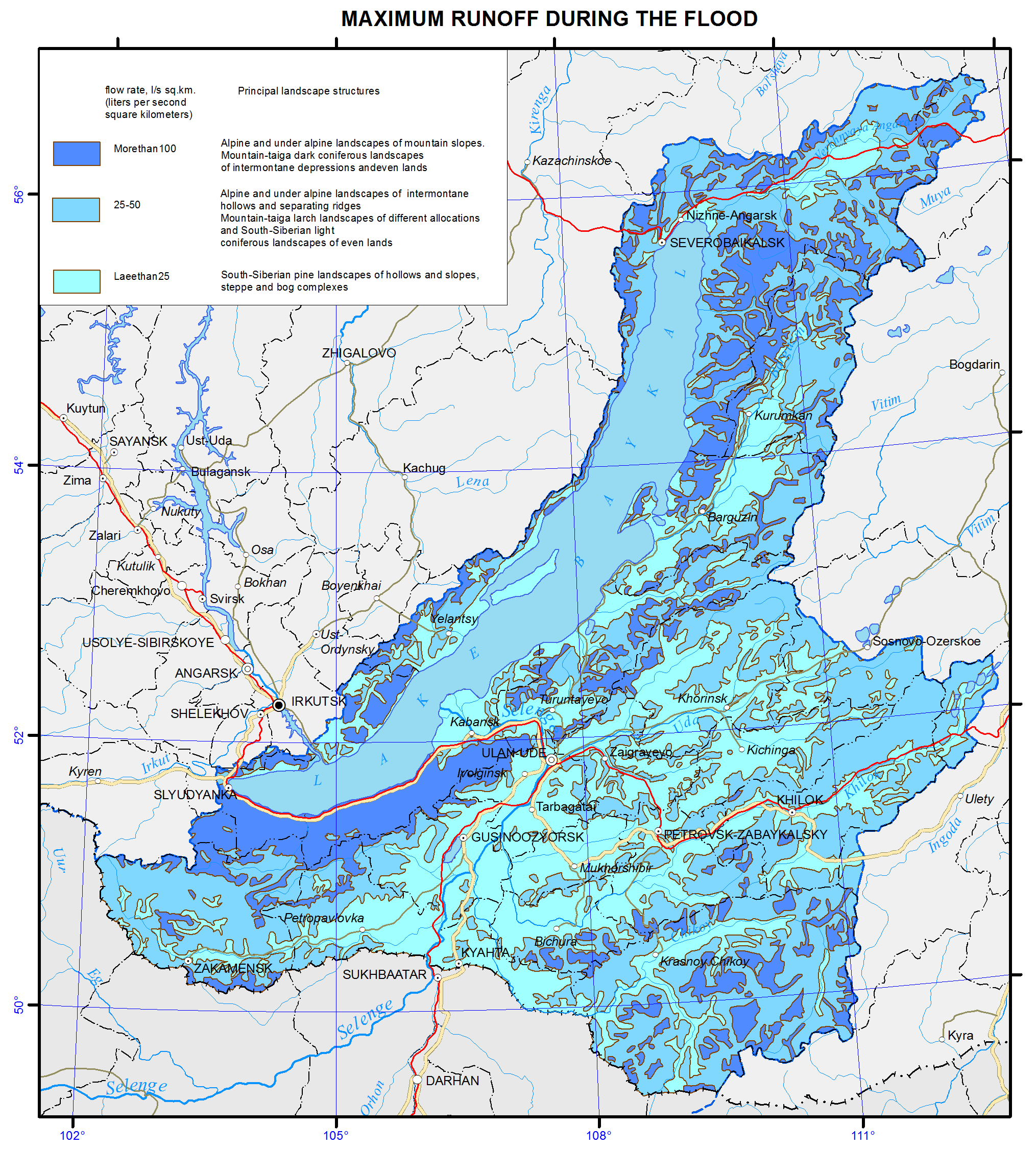
<p>Areas with the highest runoff of floods are confined to the mountain ranges and systems with goletz open woodlands and mountain-taiga landscapes. The main areas, distinguished by formation of frequent and high floods are the Baikalsky Range on the north-eastern end of the lake; Barguzinsky Range, located in the south-eastern part of the catchment, and the Khamar-Daban, covering the south-western shore of Lake Baikal. The values of the maximum flow modification are shown in three gradations on the map, namely: less than 25, 25-70, and more than 100 L/s km<sup>2</sup>.</p>
<p>Features of formation of the minimum summer runoff in the Baikal basin are associated with the regime of atmospheric moisture, as well as with the effects of altitude and exposition. The calculations and analysis of the minimum summer runoff have shown a relatively high water yield in the low-flow period from high-mountain taiga landscapes and extremely low river flow formation in the central areas of the Selenga river catchment and in Priolkhonie, which are covered with light coniferous landscapes and steppe complexes on slopes and plains. The map shows the value of the minimum flow in three gradations, namely: less than 1.5, 3.0-5.0, and more than 5.0 L/s km<sup>2</sup>.</p>
<p>Landscape-hydrological mapping based on the quantitative characteristics of water yield of landscape complexes objectively reflects the hydrological organization of the territory.</p>
<p><b> </b></p>
<p align="center">References</p>
<p>Kuznetsova T.I. (2009). Map "Natural landscapes of the Baikal region and their use: purpose, structure, and content”.  T.I. Kuznetsova, A.R. Batuev, and A.V. Bardash. <i>Geodeziya i kartografiya,</i> , no 9, pp. 18-28.</p>
<p>Landscapes of southern East Siberia [Maps]: [physical map] (1977) / compiled and prep. for printing by factory no. 4 GUGK in 1976, authors: V.S. Mikheev and V.A. Ryashin. 1: 1 500 000, Moscow: GUGK, 1 map (4 sheets): col.</p>
<p>Landscapes [Maps] [physical map] / The National Atlas of the Mongolian People's Republic. / comp .and prep to print by GUGK in 1989, authors: B.M. Ishmuratov, K.N. Misevich, I.L. Savelyeva, et al.</p>
<p>Lysanova, G.I., Semenov, Yu.M., Shekhovtsov, A.I., and Sorokovoy, A.A. (2013). Geosystems of the Republic of Tuva. <i>Geografiya i prirodnye resursy</i>, no. 3, pp. 181-185.</p>
<p>Long-term data on the regime and surface water resources. The Baikal basin. (1986). Vol. 1, no. 14, Leningrad: Gidrometeoizdat, 361 p.</p>
<p><b><i>A Regional, Electronic, Hydrographic Data Network For the Arctic Region.</i></b> <b>URL: </b><a href="http://www.r-arcticnet.sr.unh.edu/"><b>http://www.r-arcticnet.sr.unh.edu</b></a></p>]]></content:encoded>
    <dc:publisher>No publisher</dc:publisher>
    <dc:creator>Alexander Ayurzhanaev</dc:creator>
    <dc:rights></dc:rights>
    <dc:date>2014-10-06T04:20:00Z</dc:date>
    <dc:type>Page</dc:type>
  </item>


  <item rdf:about="http://bic.iwlearn.org/en/photos/map_baikalbasin">
    <title>Map_BaikalBasin</title>
    <link>http://bic.iwlearn.org/en/photos/map_baikalbasin</link>
    <description></description>
    
    <dc:publisher>No publisher</dc:publisher>
    <dc:creator>Alexander Ayurzhanaev</dc:creator>
    <dc:rights></dc:rights>
    <dc:date>2014-04-03T06:34:02Z</dc:date>
    <dc:type>Image</dc:type>
  </item>


  <item rdf:about="http://bic.iwlearn.org/en/atlas/atlas/108-malignant-neoplasms-map/malignant-neoplasms-map">
    <title>Malignant neoplasms map</title>
    <link>http://bic.iwlearn.org/en/atlas/atlas/108-malignant-neoplasms-map/malignant-neoplasms-map</link>
    <description></description>
    <content:encoded xmlns:content="http://purl.org/rss/1.0/modules/content/"><![CDATA[<p><img class="image-inline" src="../../../resolveuid/2796c2e4f47c4d5093b848d5d5a557d4/@@images/image/preview" /></p>
<p><a href="http://bic.iwlearn.org/en/atlas/photos/copy_of__108_Malignantneoplasms.png" class="internal-link">Open full size</a></p>
<p align="center"><strong>Healthcare</strong><strong> </strong></p>
<p align="center"><strong> </strong></p>
<p>Harsh climatic conditions across the entire territory of the Baikal basin and the surface and ground water used for drinking and food purposes that do not meet the drinking water quality standards (first and foremost in Mongolia and Buryatia) coupled with atmospheric emissions from industrial facilities and motor vehicles (in some parts of the territory) are responsible for the state of human health influencing the organization of healthcare. The ecological situation becomes substantially worse during winter months, which is encouraged by the topography of the terrain. In Mongolia, the spring period is very hard time to bear, with sharp temperature differences, abrupt variations in atmospheric pressure, and frequent dust and magnetic storms.</p>
<p class="NormalWeb">The organizational pattern of healthcare in Russia and Mongolia has much in common. This is a result of the cooperation of the two countries in this sphere and the fact that medical education and healthcare in Mongolia are organized using Russian experience. Today, Mongolian medical facilities operate on the principles of the state-private partnership concurrent with the demonopolization of the state system of medical services. The country has a mandatory and voluntary medical insurance system, in which state-owned and private medical institutions take part. The country also has various health institutes and centers.</p>
<p class="a">The territory of the Baikal basin is experiencing a deficit of medical workers. As of 2012, the availability of physicians varied from 13.8 to 30.1 per 10,000 people in Russian districts and from 16.1 to 29.0 per 10,000 people in Mongolian aimags. The availability of nurses varies from 25.1 to 112.2 per 10,000 people in Russian districts and from 26.4 to 38.2 per 10,000 people in Mongolian aimags. In Ulan-Ude, these indicators have the values of 53.9 and 117.3, while in Ulaanbaatar – 44.1 and 41.2, respectively.</p>
<p>The ratio of doctors and nurses in the Russian part of the basin is between 1:2 to 1:4, while in the Mongolian part it does not exceed 1:2. The World Health Organization (WHO) recommends that this ratio should be 1:4. A narrowing of this indicator causes imbalances in the healthcare system thereby limiting possibilities for further development of the after-treatment, casework and rehabilitation services.</p>
<p>Target indicators of healthcare activity are the standard volume of medical care per inhabitant. Currently, there are plans to decrease the per capita volume of in-patient services and increase the per capita volume of the hospital-replacing care. Accordingly, the number of hospital beds available 27/7 will decrease, while the number of beds in day hospitals will grow. Overall, the available number of hospital beds complies with the calculated standards and meets the demand of the population for the in-patient medical aid.</p>
<p class="ConsPlusNormal">As of today, in Russia, there is an array of problems relating to the high level of illnesses and disability incidences among the population, and these indicators are continuously growing. Such a situation is the result of inadequate preventive measures. Another important contributing factor to this situation is the increase of the proportion of elderly population and the improved effectiveness of illness detection using new diagnostic methods in the process of the increased number of medical checkups.</p>
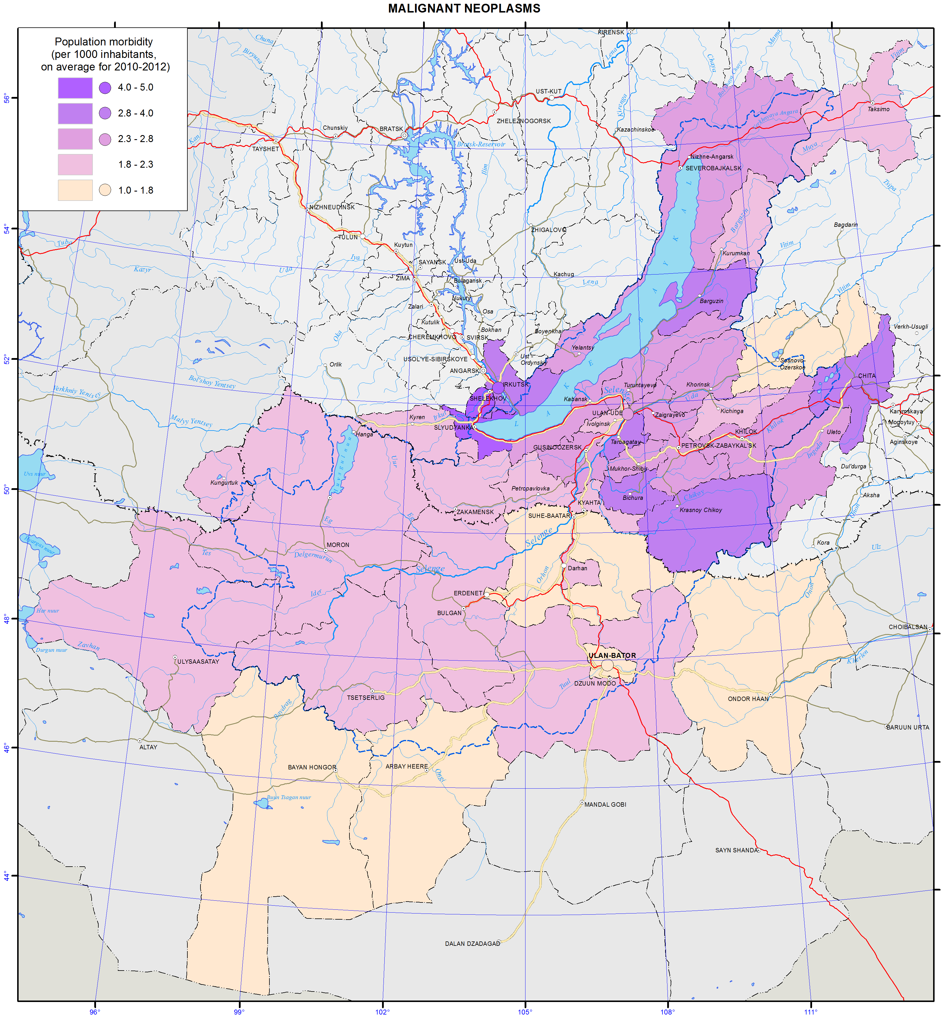
<p class="ConsPlusNormal">The leading illnesses in the structure of morbidity are respiratory illnesses, bloodstream, eye, and digestive and musculoskeletal system diseases, as well as traumas. For many years, circulatory system diseases, neoplasms, and injuries have been the main causes of mortality and disability among the population.</p>
<p class="a">A complex of anthropogenic environmental factors contributes to the growth of morbidity and disability rates among the population with the most important one being air pollution. According to the WHO, atmospheric air pollution is the cause of up to 23% of all illnesses. The amount of pollutant emissions in the atmosphere produced by static sources in different administrative divisions in the Baikal basin differs by more than a thousand times. The most polluted air in the Baikal basin is in the Selenginsky district of Buryatia.</p>
<p>The health of the population and further development of healthcare depend on ecological, social, and economic factors. These problems can be resolved only through comprehensive approaches to the improvement of the quality of life of the population.</p>
<p>The strategic goal of the healthcare systems of Russia and Mongolia is to build a system, which ensures the quality and accessibility of medical services, primarily first aid, and increases the efficiency of medical services, based on the improvement of territorial planning of healthcare. The volume, types, and quality of these services should correspond to the rate of morbidity, population requirements, and the latest achievements of medical science, based on perfecting the system of territorial planning of public health services.</p>]]></content:encoded>
    <dc:publisher>No publisher</dc:publisher>
    <dc:creator>Alexander Ayurzhanaev</dc:creator>
    <dc:rights></dc:rights>
    <dc:date>2014-10-14T02:50:00Z</dc:date>
    <dc:type>Page</dc:type>
  </item>


  <item rdf:about="http://bic.iwlearn.org/en/atlas/atlas/45-main-types-of-non-metallic-materials-map/main-types-of-non-metallic-materials-map">
    <title>Main types of nonmetallic materials map</title>
    <link>http://bic.iwlearn.org/en/atlas/atlas/45-main-types-of-non-metallic-materials-map/main-types-of-non-metallic-materials-map</link>
    <description></description>
    <content:encoded xmlns:content="http://purl.org/rss/1.0/modules/content/"><![CDATA[<p><img class="image-inline" src="../../../resolveuid/e609421c005a4d33a8cad29965afb9ce/@@images/image/preview" /></p>
<p><a href="http://bic.iwlearn.org/en/atlas/photos/copy_of__45_Maintypesofnonmetallicmaterials.png" class="internal-link">Open full size</a></p>
<p><img class="image-inline" src="../../../../resolveuid/b1d7d06c2c2f41659de254b9f3dcf0e7/@@images/image/preview" /></p>
<p><a href="http://bic.iwlearn.org/en/photos/copy_of__45_Table_Legend_Maintypesofnonmetallicmaterials.png" class="internal-link">Open full size</a></p>
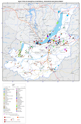
<p align="center"><strong>The main types of nonmetallic raw materials: resources and development</strong></p>
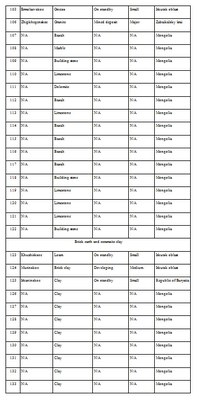
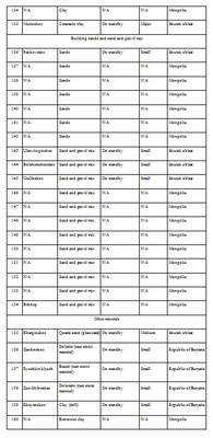
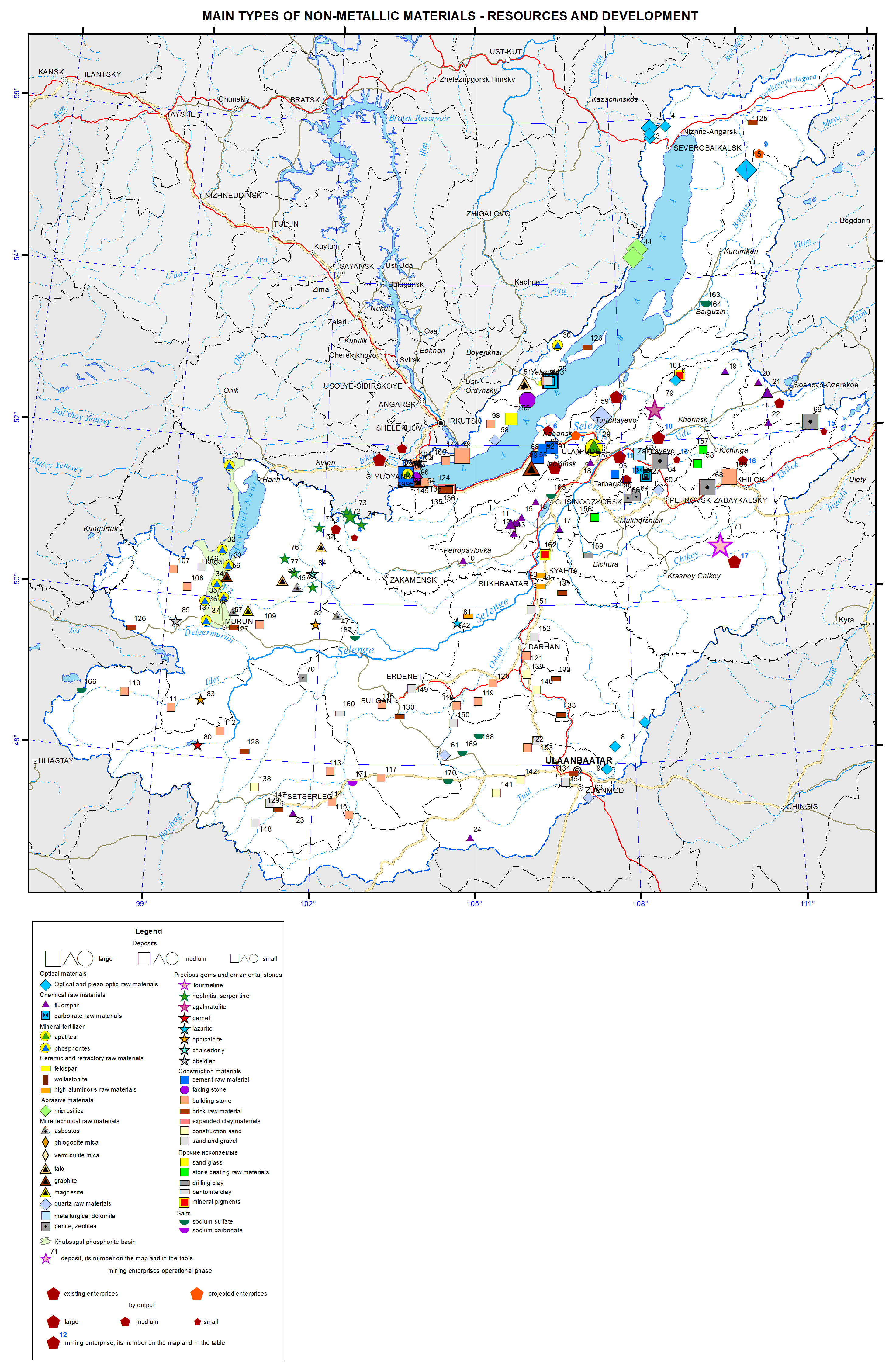
<p>Nonmetallic mineral resources of the region are of great industrial importance. Within the Baikal basin there are deposits of mining-chemical, thermo-chemical, and optical raw materials, construction materials, mineral fertilizers, ornamental and precious stones.</p>
<p>Deposits of <i>raw quartz </i>belong to strategic types of mineral resources. The region has a large raw materials base explored and prepared for industrial development: there are deposits of especially pure granular quartz (Chulbonskoe, Nadyozhnoe, Goudzhekitskoe, and others) and quartzites (Cheremshanskoe and Goloustenskoe). The vast majority of deposits are located in the territory of Buryatia; there are all prerequisites for creating a large complex of plants for deep processing of raw quartz for high-tech industries. In prospect, the republic can become the largest producer and exporter of polysilicon and total energy systems. Currently, there is a development project of the Chulbonskoe granular quartz deposit in the Severobaikalsky municipal district to get the end-product in the form of photovoltaic systems.</p>
<p>Quartzites of the mined Cheremshanskoe deposit are of exceptionally high raw materials quality meeting industrial requirements for the production of industrial silicon, silicon carbide and ferrosilicon; in recent years, research is carried out on the purest varieties to produce high-purity silicon for  helioenergetics and growing of single crystals of piezoelectric quartz. The deposit has been mined since 1992 by ZAO (Closed Joint Stock Company) “Cheremshansky quartsit” with an annual output of about 200 thousand tons and is a mineral resource base of ZAO (Closed Joint Stock Company) “Kremniy” of the OK (United Company) RUSAL, one of the most cutting edge silicon production facilities in Russia and the country's only producer of refined silicon .</p>
<p>Quartzites of the Goloustenskoe deposit can be used in metallurgy, and in the production of silica bricks. Sources of high-quality abrasive raw materials are microquartzites of two large deposits, located in the Olkhonsky municipal district on the eastern slope of the Baikal Range, namely, Srednekedrovoe and Zavorotninskoe. The latter was developed from 1975 till 1993 by “Baikalkvartssamotsvety”; currently, the deposits are on the governmental standby.</p>
<p>Considerable reserves of raw <i>fluorspar </i>were explored in the Baikal basin in the Republic of Buryatia. Currently, one deposit is mined here. It is the medium Egitinskoe deposit in the Eravninsky district; extracted ore is processed at the ore-dressing plant of the Zabaikalsky mining complex. The Naranskoe deposit in the Selenginsky district was prepared for operation and was mined for some time. The Kyakhtinskaya fluorspar factory operated near the settlement of Khoronkhoy from 1966; first it worked on local raw materials, and then on raw materials imported from Mongolia. Currently, the factory is out of operation.</p>
<p>The region possesses large reserves of chemically pure <i>limestone</i>s: in the Olkhonsky municipal district there is the Ust-Anginskoe deposit, and in the Zaigraevsky district there is the Bilyutinskoe deposit developed for the production of calcium carbide and the Tatarsky Klyuch for the paint and coatings industry. Dolomites of the Tarabukinskoe deposit are used as a raw material for glass and metallurgical production.</p>
<p>Deposits of <i>phosphate</i> raw materials are known in Cisbaikalia. They are the Sarminskoe phosphorite deposit in the Olkhon municipal district and the Slyudyanskoe apatite deposit in the Sludyansky municipal district; in northern Mongolia large reserves of formation phosphorites in the Khovsgol phosphorite basin were discovered and previously explored. The main deposits of the basin are located in the immediate vicinity of Lake Khovsgol, which is an obstacle to their development. The large Oshurkovskoe apatite deposit is prepared for exploitation near the city of Ulan-Ude. On the basis of the approved ready reserves the Zabaikalsky apatite plant was under construction; it was closed down at the building phase of an ore-dressing plant because of possible deterioration of the environmental situation in the Baikal basin. Currently, there is a project of the deposit’s development based on environmentally friendly technologies for the extraction and beneficiation of ores. Taking into account a sustained deficit of phosphate raw materials in the country, an increase of the raw materials base for the production of phosphate fertilizers is a matter of economic security of Russia. The planned standard of production of apatite concentrate is 500 thousand tons per annum. Breakstone will be produced as a by-product in the same amount of 500 thousand tons per annum.</p>
<p>Considering the <i>ceramic and fire-resisting raw materials</i>, deposits of Irkutsk oblast should be pointed out. They are the Naryn-Kuntinskoe microcline pegmatite deposit, developed earlier for the needs of the “Sibfarfor” factory, the Kharginskoe glass sands deposit, on the basis of which the Taltsy plant was established in 1784 producing a variety of glass products for 170 years, and the Asyamovskoe deposit of wollastonite, a relatively new kind of mineral products with a number of unique properties and a growing range of applications. In the south of Buryatia a sillimanite (high-alumina) shales deposit named Chyornaya Sopka is known; its ores have simple mineral composition and are easily dressed. On the basis of the deposit a non-waste production with the release of sillimanite and quartz as commercial products can be created. All the above mentioned deposits are currently on the governmental standby.<i> </i></p>
<p><i>Phlogopite mica</i> deposits in the south of Lake Baikal have been known since the second half of the 18<sup>th</sup> century. Its regular commercial production using a ramified system of underground (tunnels, mines) and open (open pits) mine openings began in 1924 with the development of the electrical engineering industry in the country and lasted until 1973. From four to seven thousand tons of high-quality raw materials were mined annually in the Sludyansky district.<i></i></p>
<p><i>Graphite </i>is represented in the region by two large deposits, namely, the Bezymyannoe (the Slyudyansky municipal district) and Boyarskoe (the Kabansky municipal district) deposits. Ores of the Bezymyannoe deposit are high quality and free-milling according to the manufacturer's tests, but the deposit is located in close proximity to Lake Baikal. The Boyarskoe deposit has the largest reserves. Economic efficiency of its development in compliance with all environmental requirements can be quite high despite low average graphite content in the ore, thanks to its favorable transportation and geographical location.</p>
<p>In the past, a considerable part of the Baikal basin experienced intense volcanic activity, the product of which is <i>pearlite</i> deposits, among which the largest ones are Mukhor-Talinskoe, Zakultinskoe, and Kholinskoe. Currently, this raw material is produced by OAO (Joint Stock Company) “Perlit” on the Mukhor-Talinskoe deposit with the production output amounting to 1-10 thousand m<sup>3</sup> of raw material per annum over the last three years. The Kholinskoe pearlite and zeolite deposit is located on the border of the Republic of Buryatia and Zabaikalsky krai; the mining OOO (Limited Liability Company) “Kholinskie tseolity” develops the deposit. Nowadays, the capacity of the company mining such a valuable kind of mineral product as zeolites is small and amounts to only about 0.8 thousand tons.</p>
<p>Within the region there are a number of deposits of <i>precious and ornamental stones</i>. In Zabaikalsky krai, ZAO (Closed Joint Stock Company) “Turmalkhan” develops a unique deposit of jewelry tourmaline, which is the only one in Russia to date. In the Republic of Buryatia, OOO (Limited Liability Company) “Kaskad” exploits the Khargantinskoe deposit with an annual production of 20 tons of raw jade; ZAO (Closed Joint Stock Company) “MS Holding” started to develop the Khamarkhudinskoe jade deposit, where 510 tons were produced in 2012.</p>
<p>To meet the needs of the construction industry the region possesses significant resources of <i>mineral construction materials</i>: numerous deposits of cement, brick, sand and gravel raw materials, building and facing stone are explored in the area. The raw materials base of the Angarsky cement plant is the large Slyudyanskoe deposit of cement marbles, being developed by the OOO (Limited Liability Company) “Karyer Pereval” with an annual output of about 900 thousand tons. The Tarakanovskoe deposit of cement limestone and Timlyuiskoe deposit of loam supply the Timlyuisky cement plant with raw materials. OOO (Limited Liability Company) “Timlyuitsement” produces 250-400 thousand tons of limestone and 20-35 thousand tons of loam annually.</p>
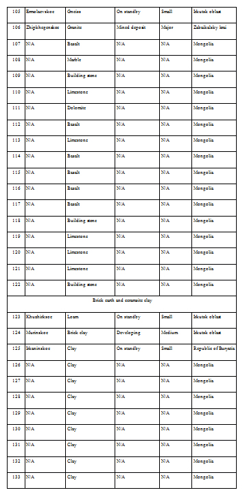
<p>Facing stone deposits are located on the western and south-eastern shores of Lake Baikal; they are Burovshchina and Novo-Burovshchinskoe deposits of pink marbles and Buguldeiskoe deposit of highly-ornamental statuary marble of various color shades: from snow-white to smoky-gray. Currently, stone is not produced on any of these deposits. Among building stone deposits AO (Joint Stock Company) RZhD exploits two: one of them is the medium Angasolskoe deposit in Irkutsk oblast and the other is the large Zhipkhegenskoe deposit in Zabaikalsky krai forming the raw materials base of the same-name crushed stone plants. Several deposits of building stone are situated in the coastal zone of Lake Baikal, namely, Baikalskoe, Ermolaevskoe, Dinamitnoe and others, rendering their development impossible.</p>
<p>The following deposits of brick and keramzite claysand loams were discovered: the Murinskoe and Khuzhirskoe deposits in Cisbaikalia and Irkaninskoe deposit in the Severobaikalsky municipal district, deposits of sand-gravel mix, including the Utulikskoe deposit of high-quality raw materials, the Pankovskoe deposit of building sands, and so on.</p>
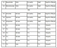
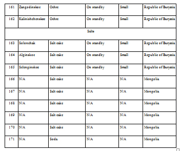
<p>Among <i>other</i> mineral resources of the region, the Zangodinskoe and Kalinishenskoe deposits of mineral paints, Khayanskoe deposit of drilling clays, several deposits of raw materials for stone casting, as well as deposits of mineral salts (sodium sulfate) should be mentioned. All deposits of these raw materials are small in terms of reserves and are on the governmental standby.</p>
<p>In Mongolia small deposits of asbestos, gypsum, graphite, talcum, magnesite, bentonite, ornamental stones (nephrite, serpentinite, lapis lasuli, ophicalcite, chalcedony, etc.), raw quartz, and mineral salts are known within the Baikal basin. As for construction materials there are deposits of building sand, brick, keramzite and ceramic clays, sand-gravel mix, building stone, etc.</p>
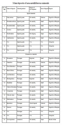
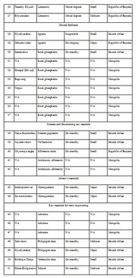
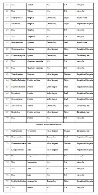
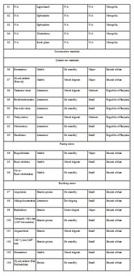
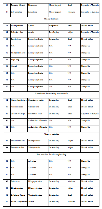
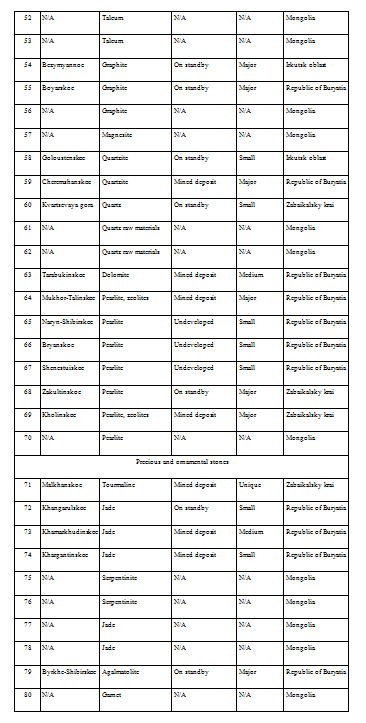
<p>The map presents the main nonmetallic mineral raw materials deposits, depending on their size and type of mineral product, as well as mining companies using symbols. The size of the symbol designating a company depends on the average production output over the recent three to five years or on the planned capacity of the objects designed and under construction; gradation is presented in the summary table. The color of the symbol corresponds to the operational phase of an enterprise. The Khubsugulsky phosphorite basin is shown with an areal.</p>
<p>Map construction required the use of the materials of the Regional Funds of Geological Information, maps of mineral resources of the A.P. Karpinsky Russian Geological Research Institute; materials of State Reports “On the Condition of Lake Baikal and Measures of its Protection” for 2010–2012; “National Atlas of the Mongolian People's Republic” (1990), “Atlas of Mongolia” in the Mongolian language (2010), and “Atlas of Socioeconomic Development of Russia” (2009). Information on deposits according to the types of raw materials and on mining companies is presented in the summary table.</p>
<p><img class="image-inline" src="../../../../resolveuid/d284b6f61e4c44f8ad43d46a668322d3/@@images/image/preview" /></p>
<p><a href="http://bic.iwlearn.org/en/photos/45.jpg" class="internal-link">Open full size</a></p>
<p><img class="image-inline" src="../../../../resolveuid/98bbb5cc2eef41158328f7f0eeb57425/@@images/image/preview" /></p>
<p><a href="http://bic.iwlearn.org/en/photos/451.jpg" class="internal-link">Open full size</a></p>
<p><img class="image-inline" src="../../../../resolveuid/a62eb843c052454cb3739df217414e92/@@images/image/preview" /></p>
<p><a href="http://bic.iwlearn.org/en/photos/452.jpg" class="internal-link">Open full size</a></p>
<p><img class="image-inline" src="../../../../resolveuid/6a6a2fd6be0d47ea9f98156bdefaf7d7/@@images/image/preview" /></p>
<p><a href="http://bic.iwlearn.org/en/photos/453.jpg" class="internal-link">Open full size</a></p>
<p><img class="image-inline" src="../../../../resolveuid/ae9af4a5656a4070a90f7207e47a3c60/@@images/image/preview" /></p>
<p><a href="http://bic.iwlearn.org/en/photos/454.jpg" class="internal-link">Open full size</a></p>
<p><img class="image-inline" src="../../../../resolveuid/dd33f181df6e436c924598b054fbd494/@@images/image/preview" /></p>
<p><a href="http://bic.iwlearn.org/en/photos/455.jpg" class="internal-link">Open full size</a></p>
<p><img class="image-inline" src="../../../../resolveuid/17b13986651f47f7bbddb28738053f17/@@images/image/mini" /></p>
<p><a href="http://bic.iwlearn.org/en/photos/456.jpg" class="internal-link">Open full size</a></p>]]></content:encoded>
    <dc:publisher>No publisher</dc:publisher>
    <dc:creator>Alexander Ayurzhanaev</dc:creator>
    <dc:rights></dc:rights>
    <dc:date>2014-10-08T01:50:00Z</dc:date>
    <dc:type>Page</dc:type>
  </item>


  <item rdf:about="http://bic.iwlearn.org/en/friends/local-environmental-public-organization-turka-russia-buryat-republic">
    <title>Local environmental public organization «Turka» (Russia, Republic of Buryatia)</title>
    <link>http://bic.iwlearn.org/en/friends/local-environmental-public-organization-turka-russia-buryat-republic</link>
    <description></description>
    <content:encoded xmlns:content="http://purl.org/rss/1.0/modules/content/"><![CDATA[<p align="center"><strong>LOCAL ENVIRONMENTAL PUBLIC</strong></p>
<p align="center"><strong>ORGANIZATION «TURKA»</strong></p>
<p><span style="text-decoration: underline;">Contact information:</span></p>
<p>671273, Republic of Buryatia, Pribaikalskiy district,</p>
<p>village Turka, October st., 89</p>
<p>Tel .: (301-44) 54-8-97, 25/9/54, 54-7-76. Fax: 8 (30144) 54-6-98.</p>
<p>E-mail: tivikova-t@mail.ru</p>
<p><span style="text-decoration: underline;">Chair:</span> Tatyana Alekseevna Tivikova</p>
<p><span style="text-decoration: underline;">Year of establishment:</span> 21 November 2001</p>
<p><span style="text-decoration: underline;"> </span></p>
<p><span style="text-decoration: underline;">The purposes of establishment:</span> the association of intellectual potential, basic and financial resources, institutional capacity of members for activities aimed to the nature preservation and environmental education.</p>
<p><span style="text-decoration: underline;">Main activities</span></p>
<p>- The collection, storage, analysis and dissemination of information about the condition of the environment;</p>
<p>- Research and develop recommendations for the nature protection in Turka village;</p>
<p>- Assistance to stakeholders, both legal and physical, in activities aimed to nature preservation in Turka village;</p>
<p>- Promoting the efficiency of environmental education.</p>
<p style="text-align: center; "><img class="image-inline" src="../../resolveuid/354409f538c2493eb8869ae03d708de9/@@images/image/preview" /></p>
<p align="center">Head of the organization Tatyana Tivikova</p>
<p><span style="text-decoration: underline;">Implementation of projects</span></p>
<p><strong>UNDP «Every Drop Matters - Lake Baikal»</strong></p>
<p>In 2011, executed projects:</p>
<p>- «Clean shore for the Lake Baikal». Cleanup activities at the shore of Lake Baikal, started landscaping. The recreation places are provided by tables, benches, gazebos, and equipped campfire places. Everything was made from natural materials.</p>
<p>- «Turkinsky Bazaar». In the center of Turka village built a shed with a counter for selling to tourists environmentally friendly products which collected in the forest or grown by local residents in their backyards (wild plants, vegetables, fish, meat, milk, etc.);</p>
<p>- «Clean shore for Lake Baikal, comfortable rest for tourists». In 2012, organized student’s work with tourists: raids, distribution of leaflets and booklets on environmental topics.</p>
<p>- «Baikal – clean rivers and streams». In 2013 was developed study of rivers and streams in the territory of the municipality «Turkinskoe». By method of bioindication collected baseline data of water quality in the river Turka above and downstream treatment facilities of Special economic zone (SEZ) «Baikal Harbor». The recreation places near the bridges, near the river banks along the road Ulan-Ude – Barguzin were equipped by gazebos, tables, benches and campfire places made from natural materials.</p>
<p>- «Berendeev forest». Implemented in the summer of 2013 with the support of Global Greengrants. Inside Turka village on the shore of the Lake Baikal, in the area of the forest, where grow ancient cedars and pines, have been built playground from natural materials (gnarled trees), installed a fabulous figure of Berendey and other heroes of the Russian tales, built a hut, gates, seasaw, bridge, and benches. On the playground «grow» mushrooms – boletus (ceps). This place is now popular among adults and children.</p>
<p>- Participation in the action «360 minutes for Baikal» in autumn 2013, cleanup activities at Turkinsky beach.</p>
<p>Together with local residents defended the transfer of parts of the coast of Lake Baikal area «Turkinsky beach» and section «Turka-Goryachinsk» where there is a stone «Cherepakha» (Turtle), from the extension of SEZ «Baikal Harbor».</p>
<p>Currently implementing project <strong>«Providing by clean water local people of the Turka and Goryachinsk»</strong>. Planned to repair two water carriers, overhaul two wells with the replacement of deep-well pumps in villages Goryachinsk and Turka.</p>]]></content:encoded>
    <dc:publisher>No publisher</dc:publisher>
    <dc:creator>Alexander Ayurzhanaev</dc:creator>
    <dc:rights></dc:rights>
    <dc:date>2015-02-06T03:35:00Z</dc:date>
    <dc:type>Page</dc:type>
  </item>


</rdf:RDF>