<?xml version="1.0" encoding="utf-8" ?>
<rdf:RDF xmlns:rdf="http://www.w3.org/1999/02/22-rdf-syntax-ns#" xmlns:dc="http://purl.org/dc/elements/1.1/" xmlns:syn="http://purl.org/rss/1.0/modules/syndication/" xmlns="http://purl.org/rss/1.0/">


<channel rdf:about="http://bic.iwlearn.org/search_rss">
  <title>Байкальский информационный центр</title>
  <link>http://bic.iwlearn.org</link>

  <description>
    
            These are the search results for the query, showing results 151 to 165.
        
  </description>


  <image rdf:resource="http://bic.iwlearn.org/logo.png"/>

  <items>
    <rdf:Seq>
      
        <rdf:li rdf:resource="http://bic.iwlearn.org/en/atlas/atlas/81-religions-map/religions-map"/>
      
      
        <rdf:li rdf:resource="http://bic.iwlearn.org/en/atlas/atlas/80-education-map/education-map"/>
      
      
        <rdf:li rdf:resource="http://bic.iwlearn.org/en/atlas/atlas/79-sulture-map/sulture-map"/>
      
      
        <rdf:li rdf:resource="http://bic.iwlearn.org/en/atlas/atlas/78a-comfort-of-available-housing-russian-part-map/comfort-of-available-housing-russian-part-map"/>
      
      
        <rdf:li rdf:resource="http://bic.iwlearn.org/en/atlas/atlas/77-housing-conditions-map-1/housing-conditions-map"/>
      
      
        <rdf:li rdf:resource="http://bic.iwlearn.org/en/atlas/atlas/76-net-migration-rate-map/net-migration-rate-map"/>
      
      
        <rdf:li rdf:resource="http://bic.iwlearn.org/en/atlas/atlas/77-housing-conditions-map-1"/>
      
      
        <rdf:li rdf:resource="http://bic.iwlearn.org/en/atlas/atlas/75-urbanization-map/urbanization-map"/>
      
      
        <rdf:li rdf:resource="http://bic.iwlearn.org/en/atlas/atlas/74-natural-population-increase-map/natural-population-increase-map"/>
      
      
        <rdf:li rdf:resource="http://bic.iwlearn.org/en/atlas/atlas/73-population-dynamics-map/population-dynamics-map"/>
      
      
        <rdf:li rdf:resource="http://bic.iwlearn.org/en/atlas/atlas/72-rural-population-density-and-urban-settlement-population-size-2013-map/rural-population-density-and-urban-settlement-population-size-2013-map"/>
      
      
        <rdf:li rdf:resource="http://bic.iwlearn.org/en/atlas/atlas/71-rural-population-density-and-urban-settlement-population-size-1989-map/rural-population-density-and-urban-settlement-population-size-1989-map"/>
      
      
        <rdf:li rdf:resource="http://bic.iwlearn.org/en/atlas/atlas/70-population-density-map/population-density-map"/>
      
      
        <rdf:li rdf:resource="http://bic.iwlearn.org/en/atlas/atlas/69-functional-ecological-settlement-types-map/functional-ecological-settlement-types-map"/>
      
      
        <rdf:li rdf:resource="http://bic.iwlearn.org/en/atlas/atlas/68-transport-infrastructure-map/transport-infrastructure"/>
      
    </rdf:Seq>
  </items>

</channel>


  <item rdf:about="http://bic.iwlearn.org/en/atlas/atlas/81-religions-map/religions-map">
    <title>Religions map</title>
    <link>http://bic.iwlearn.org/en/atlas/atlas/81-religions-map/religions-map</link>
    <description></description>
    <content:encoded xmlns:content="http://purl.org/rss/1.0/modules/content/"><![CDATA[<p><img class="image-inline" src="../../../resolveuid/3d26c14de33f41b6ad5073b66c147fca/@@images/image/preview" /></p>
<p><a href="http://bic.iwlearn.org/en/atlas/photos/copy_of__81_Religions.png" class="internal-link">Open full size</a></p>
<p align="center"><strong>Religions</strong></p>
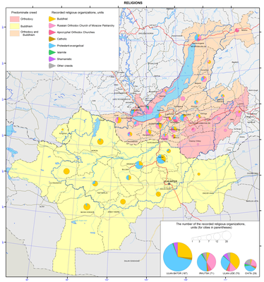
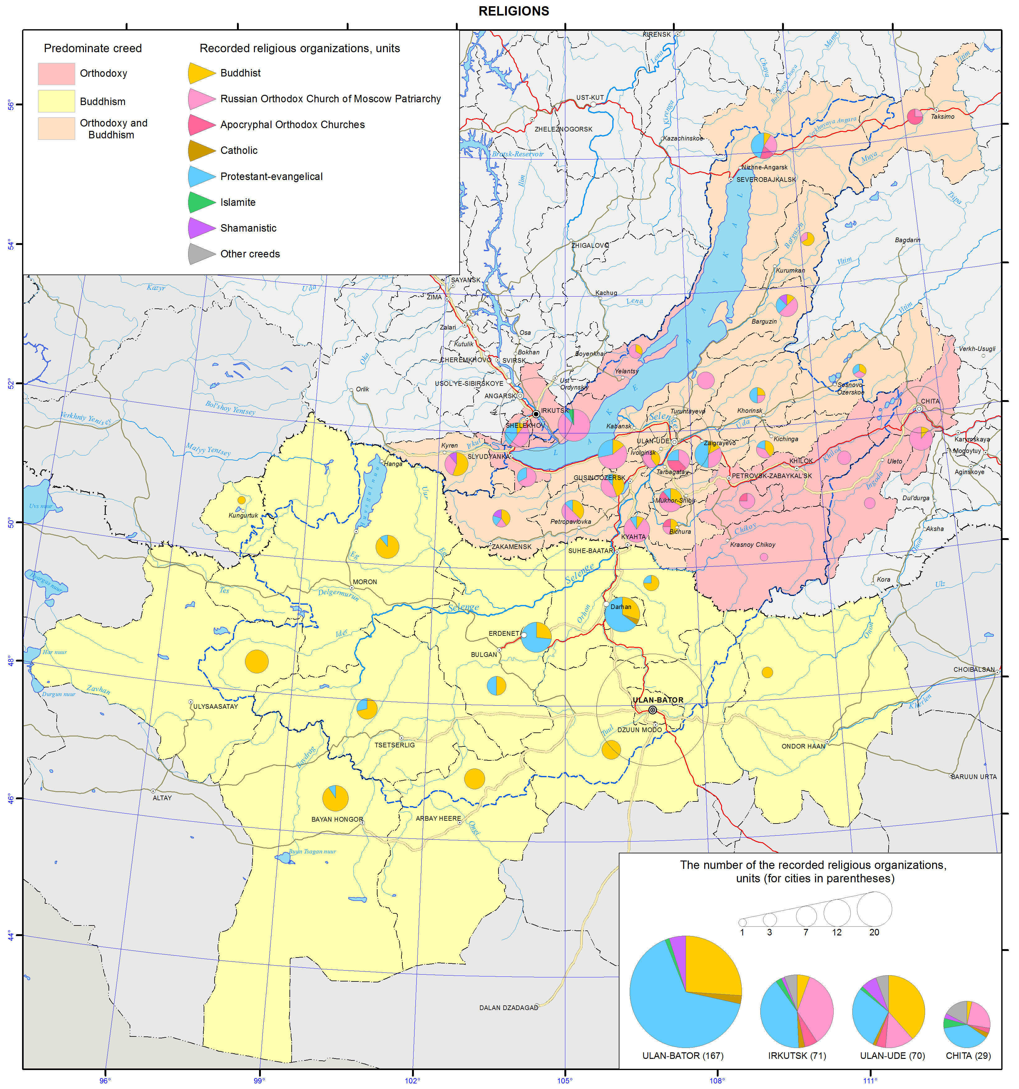
<p>Traditional religions in the Baikal basin include Shamanism, Buddhism in the form of Lamaism, and Russian Orthodox Christianity. Current religious situation is, to a large measure, determined by political reforms that were carried out in Mongolia and Russia in the 1990s. Now, there are a plethora of religious denominations and practices.</p>
<p class="1">The majority of the population is religious. In most cases, undecided and non-believers still associate themselves with a particular traditional religion. In Mongolia, for example, about 90% of the population identify themselves with Buddhism, while 6% - with Shamanism. On the other hand, according to the 2010 census, 61.4% of the population 15 years of age or older identified themselves as believers. Buddhists, Muslims, Shamanists, Christians and adherents of other religions constituted 53, 3, 3, 2, and &lt;1%, respectively. In Buryatia, the most widespread self-identifications are with two religions: Buddhism and Russian Orthodox Christianity. In Zabaikalsky krai and Irkutsk oblast, the overwhelming majority of the people identify themselves as Russian Orthodox Christians, whereas Buddhism holds the lead in Tuva. According to the opinion poll data collected in 2012 by the Nonprofit Research Service “Sreda”, the proportion of residents professing Buddhism in the aforementioned regions constituted, respectively, 20; 6; &lt;1; 62; Christianity: 32; 32; 48; 2 (including Russian Orthodox: 27; 25; 41; 1), Islam: &lt;1; &lt;1; 7; ; &lt;1; Shamanism: 2; &lt;1; 1; 8; and other religions: &lt;1; &lt;1;&lt;1; &lt;1%.</p>
<p>Although religious organizations must register, there are some unregistered groups. They steadily grow in number with the fastest growth among Protestant and Evangelical groups.</p>
<p>The population is tolerant toward different religions. Contradictory and mixed religious views often coexist. <b></b></p>
<p>Buddhism in the Baikal basin (its concepts, rites, rituals, mythology, and spirits) was influenced by the religious customs that had existed before it was introduced in this region.</p>
<p>Buddhist monasteries take an important place in the social (and ecological) life. They organize the dialog with science and education. Not only Buddhist monks, but also secular specialists are invited to give lectures at monasteries. Publishing is a major activity of monastic centers. Much attention is given to the formation and preservation of the cultural memory of the people, as well as to the issues related to the adjustment of the Buddhist teaching to current conditions and its further development, including among the ethnically Russian population. <b></b></p>
<p>Christianity in the Russian part of the Baikal basin is mostly represented by the Russian Orthodox Church. In the Mongolian part of the basin, it is mainly Protestant and Evangelical organizations (90% Protestants, mainly Evangelicals and Baptists, 9% Mormons, 1% Catholics and Russian Orthodox believers).</p>
<p>Christianity views the resolution of environmental issues as a component of the ministerial and missionary services to God. According to the Bible, everything on Earth was created by God. Nature was created to satisfy human needs. However, it is not just a reservoir of resources for egoistic and irresponsible consumption, but a temple, in which an individual serves God. The individual is responsible for his/her thoughts and acts and must treat the nature with care. Life in all its different manifestations has a sacred character; its destruction or disturbance is a challenge to God.</p>
<p class="1">According to Christianity, ecological problems are the consequences of egoistic and consumer impulses. Therefore, ecological activity will fail to reach the desired results, unless people begin to live by Christian commandments. <b></b></p>
<p>Islam (mostly Sunni Islam) has an ethnic character. In the Russian territory, the majority of Muslims are ethnic Tatars. In Mongolia, they are the not-so-numerous Kazakhs, Uzbeks, Uighurs, Tatars, and other Muslim ethnicities.</p>
<p>According to the Quran, the Man and the Nature are the great sacred creations of Allah. People are responsible for the preservation, purity, and beauty of the nature. All living beings on Earth are like the Man. Torturing them is absolutely prohibited. Any good done to an animal is equally beneficial as any good done to the Man. The efforts of the Man to do good to the nature is regarded as a virtue, which helps him or her gain blessings and Paradise in the future life.</p>
<p>Islam pays much attention to the improvement in the condition of Earth with human hands. It poses the question about the union of science and religion in dealing with environmental problems.</p>
<p class="1">Shamanism is the oldest religion of Siberia and Central Asia. It is thought to be originated on Olkhon Island (on Lake Baikal), which is considered to be a sacred place. According to the concepts of Shamanism, there are three worlds: upper (heavenly), middle (terrestrial), and lower (subterranean). Nowadays, Shamanism also includes the followers of Tengrism, a global religion, which demonstrates a tendency towards a philosophical-metaphysical monotheism practiced by early nomadic communities in Mongolia.</p>
<p class="1">A careful use of natural resources is based on the cultural and religious traditions. Local natural sites play an important role in the concepts of the universe. Previously, Shamanism “served” the communal-tribal sphere, and each tribe and clan had their own sacred places, where rituals were conducted. In such places, they built ovoos and tied ribbons to tree branches.</p>
<p class="1">The ecological concepts of other religions in the Baikal basin are also directed towards nature conservation.</p>
<p>According to all religions, the resolution of environmental problems must begin with the spiritual and moral improvement of human beings.</p>]]></content:encoded>
    <dc:publisher>No publisher</dc:publisher>
    <dc:creator>Alexander Ayurzhanaev</dc:creator>
    <dc:rights></dc:rights>
    <dc:date>2014-10-10T00:30:00Z</dc:date>
    <dc:type>Page</dc:type>
  </item>


  <item rdf:about="http://bic.iwlearn.org/en/atlas/atlas/80-education-map/education-map">
    <title>Education map</title>
    <link>http://bic.iwlearn.org/en/atlas/atlas/80-education-map/education-map</link>
    <description></description>
    <content:encoded xmlns:content="http://purl.org/rss/1.0/modules/content/"><![CDATA[<p><img class="image-inline" src="../../../resolveuid/30b4588a61dc43cf8071a239b46ead4c/@@images/image/preview" /></p>
<p><a href="http://bic.iwlearn.org/en/atlas/photos/copy_of__80_Education.png" class="internal-link">Open full size</a></p>
<p align="center"><strong>Educational</strong></p>
<p>Education is an important factor of economic and social development. An individual, her or his knowledge and skills, and the ability to make nonstandard decisions in a rapidly changing economic environment are the most valuable element of society. Educational services can become a lever that can push the economy to a qualitatively new stage of development.<b></b></p>
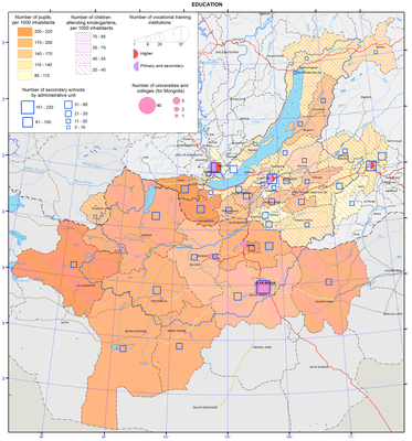
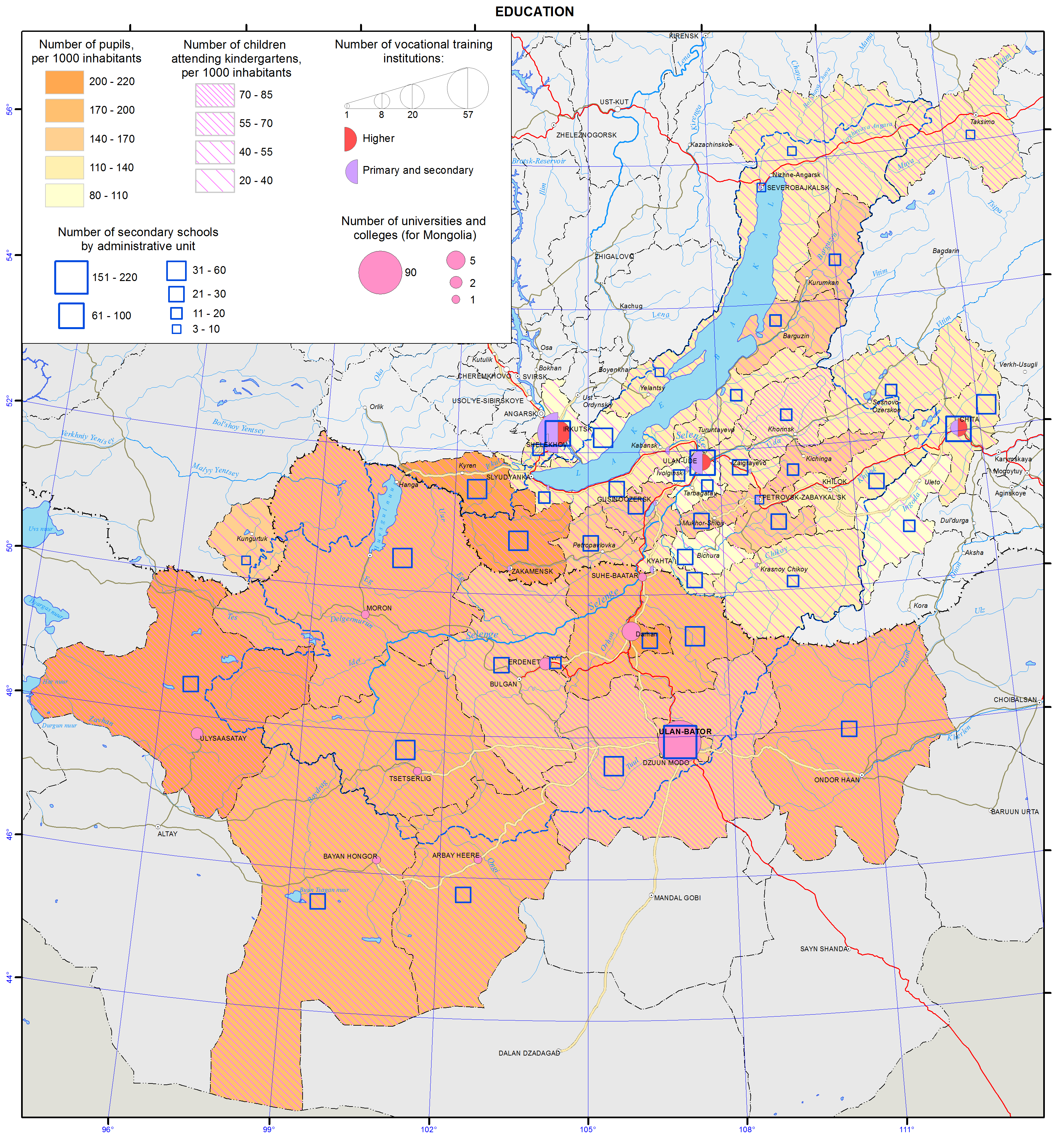
<p>Preschool education aims to support mental, personal, and physical development of children aged 2 to 8 years. Depending on the laws, traditions and cultures, the approach to preschool education varies. It can have different basic and specific tasks. It can be compulsory or voluntary, and it may be implemented through a variety of traditional institutions. Within the study area, there are 1,436 preschool educational institutions with about 237.6 thousand children.</p>
<p>Secondary education is the first level of education. Currently, it usually includes primary, basic secondary, and secondary (complete) education, as well as additional education of children. In the Baikal basin, there are 1,412 secondary schools with about 637.5 thousand children.</p>
<p>In the Irkutsk part of the basin, there are 206 kindergartens with 35,268 children and 182 secondary schools with 86,982 students. In the Republic of Buryatia, there are 394 kindergartens with 45,007 children and 517 secondary schools with 123,362 students. In Zabaikalsky krai, there are 150 kindergartens with 24,119 children and 187 secondary schools with 57,210 students. In Mongolia, there are 685 kindergartens with 133,239 children and 523 secondary schools with 369,900 students.</p>
<p>Secondary vocational education (SVE) is a level of professional education, which aims to train practical specialists and mid-level employees for all industries. The training is carried out on the basis of basic secondary (after the 9<sup>th </sup>grade), complete secondary (after the 11<sup>th </sup>grade), or primary vocational education.</p>
<p>Today, there are 100 secondary vocational schools in the Russian part of the Baikal basin. In Mongolia, secondary vocational education is represented by 35 professional and technical schools.<b></b></p>
<p>Higher professional education (HPE) is a level of professional education, which aims to train specialists in any field of science on the basis of the complete secondary or secondary vocational education.</p>
<p>Higher professional education in the Russian territory of the Baikal basin is provided by 40 universities (state and private and their branches). In the Mongolian part, there are 29 state and 40 private universities, mostly located in the capital.</p>
<p>The scientific complex of the territory includes nine academic institutes of the Irkutsk Scientific Center SB RAS, five institutes of the East-Siberian Scientific Center SB RAMS, three research organizations SB RAAS, and over 30 applied research and design institutes. The system of academic science of the Republic of Buryatia includes the Buryat Scientific Center SB RAS (BSC SB RAS) and the Buryat Research Institute of Agriculture SB RAAS.</p>
<p>The university sector of scientific activities includes research divisions of four universities of the Republic. The scientific and innovation potential of Zabaikalsky krai is represented by the academic and university science. Currently, five academic and research institutions, including branches, operate in Zabaikalsky krai.</p>
<p>Mongolian Academy of Sciences was founded in 1961 in Ulaanbaatar on the basis of the Committee of Sciences (1921 to 1929 – Scientific Committee). Currently, it includes seven sections and over 60 research institutes, observatories, and research stations.</p>
<p> </p>
<p align="center">References</p>
<p>Federal State Statistics Service. Retrieved from http://www.gks.ru</p>
<p>National Statistical Office of Mongolia. (2013). <i>Soyol, sport, ayalal, zhuulchlalyn salbaryn lavlakh</i>. Ulaanbaatar. p. 285.</p>
<p>National Statistical Office of Mongolia. (2012). <i>Mongol ulsyn statistikiyn Emkhetgel</i>. Ulaanbaatar.</p>]]></content:encoded>
    <dc:publisher>No publisher</dc:publisher>
    <dc:creator>Alexander Ayurzhanaev</dc:creator>
    <dc:rights></dc:rights>
    <dc:date>2014-10-09T07:20:00Z</dc:date>
    <dc:type>Page</dc:type>
  </item>


  <item rdf:about="http://bic.iwlearn.org/en/atlas/atlas/79-sulture-map/sulture-map">
    <title>Culture map</title>
    <link>http://bic.iwlearn.org/en/atlas/atlas/79-sulture-map/sulture-map</link>
    <description></description>
    <content:encoded xmlns:content="http://purl.org/rss/1.0/modules/content/"><![CDATA[<p><img class="image-inline" src="../../../resolveuid/5bbc6860c7fd439f9ece1c841e59deb4/@@images/image/preview" /></p>
<p><a href="http://bic.iwlearn.org/en/atlas/photos/copy_of__79_ulture.png" class="internal-link">Open full size</a></p>
<p align="center"><strong>Culture. Education</strong></p>
<p>Education and culture are important parameters of the quality of life of population in particular areas. To some extent, they characterize the standard of life and “spiritual environment”. The main source of information for creating these maps included official statistical data for 2012 (in some cases for 2011). Materials of the Russian Federal State Statistics Service and Mongolian statistical yearbooks were also used in this work.<b> </b></p>
<p align="center"><b> </b></p>
<p align="center"><b>Cultural establishments</b></p>
<p>Cultural establishments are keepers and successors of the historical and cultural memory of the people, as well as mediators in its transfer to the next generations. Usually, cultural establishments include libraries, museums, theaters, clubs, cultural centers, cinemas, leisure centers, and cultural complexes.</p>
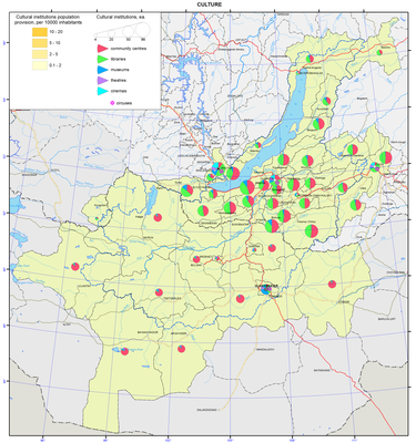
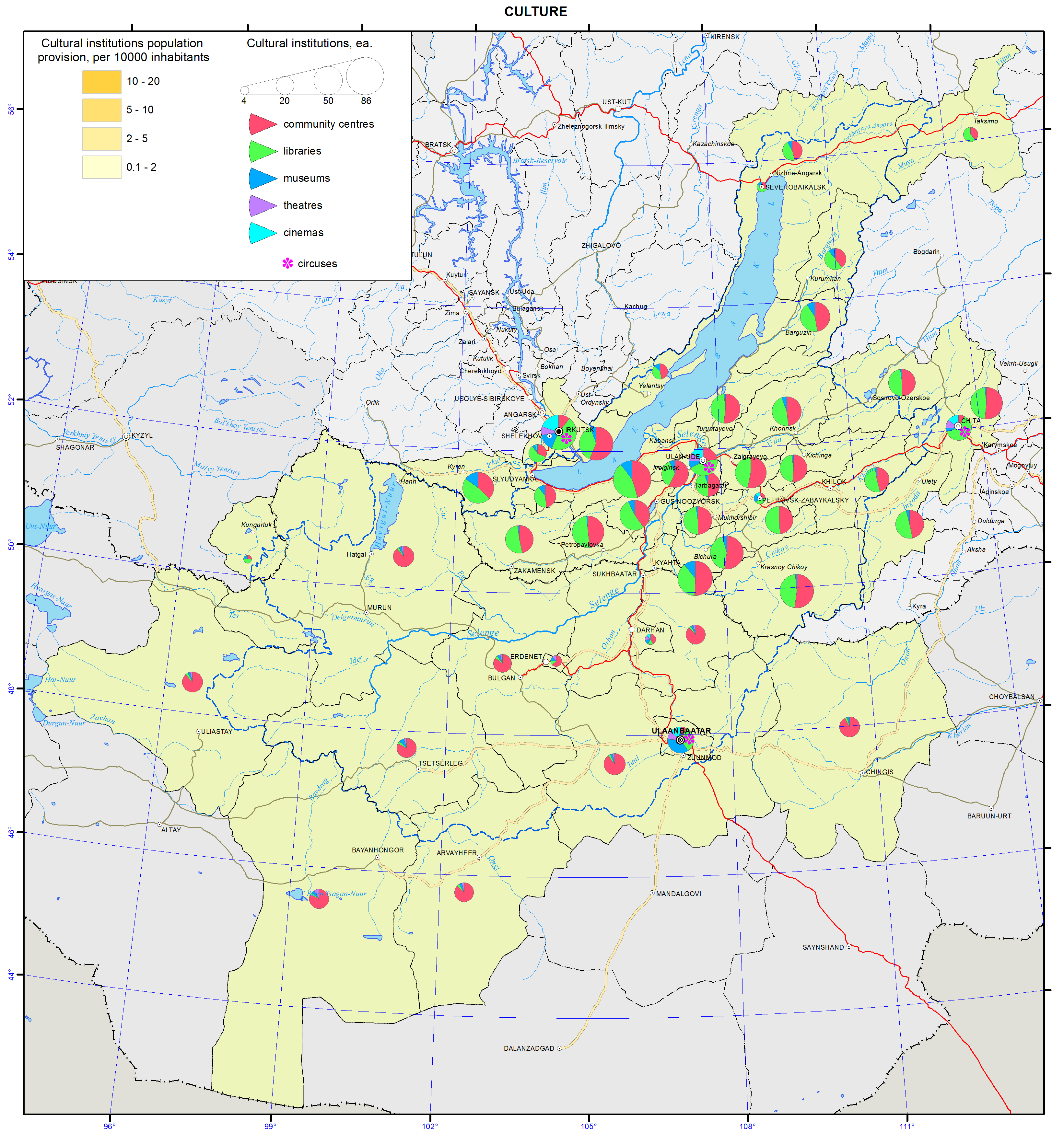
<p>In the Baikal basin, there are about 1,770 cultural establishments. The total number of cultural-and-leisure centers in this region is 875. There are 720 libraries, 106 museums, 30 theaters, 36 cinemas, and 4 circuses. In the Russian part of the basin, there are 247 children’s music, art, and dance schools. Each administrative district has cultural-and-leisure centers (clubs) and libraries. Most of the districts also have museums.</p>
<p>Cultural life is most vividly represented in the major cities of Ulaanbaatar, Irkutsk, Chita, and Ulan-Ude. There are famous theaters, museums, circuses, large libraries, and cinemas.<b></b></p>
<p class="1">Museums<b> </b>serve as the main tool of memory materialization. Often, they focus on local history and ethnography. Museums give tourists information emphasizing the originality and specificity of a particular place, its nature, history, and culture. Thematically, museums of regional centers (Ulaanbaatar, Irkutsk, Ulan-Ude, and Chita) are quite diverse. In the Irkutsk part of the basin, the most valuable collections are kept at the oldest museums, such as the V. P. Sukachev Museum of Art, Irkutsk Museum of Regional Studies, Taltsy Museum of Wooden Architecture and Ethnography, Historical and Memorial Museum of Decembrists, and Baikal Museum of the Irkutsk Scientific Center SB RAS in Listvyanka. Among the largest museums in the Republic of Buryatia are the Sampilov Museum of Fine Arts, Museum of Natural History of Buryatia, and Ethnographic Museum (all in Ulan-Ude), as well as the Kyakhta Museum of Regional Studies. The prevailing type of museums in Zabaikalsky krai are historical museums of regional studies illustrating the rich history of the region’s development and the life of Decembrists and other exiles. The State Central Museum of Mongolia holds a comprehensive and unique collection of artifacts offering an opportunity to learn about the country’s natural history.<b></b></p>
<p class="1">Theatrical life in the region is represented by a number of establishments. There are the Okhlopkov Academic Drama Theatre, Zagursky Musical Theatre, Puppet Theatre “Aistenok”, Vampilov Youth Theatre, and Children’s Circus in Irkutsk. In the Republic of Buryatia, there are the Buryat State Academic Opera and Ballet Theatre, steeped in tradition Khotsa Namsaraev Buryat State Academic Drama Theatre, and Nikolay Bestuzhev State Russian Drama Theatre, which is the oldest theatre company in the Republic. In Buryatia, there are also avant-garde theaters, namely, the Ulan-Ude Youth Theatre-Studio and Theatre-Studio of Modern Body Movement and Pantomime “AzArt”. There are also Buryat State Philharmonic, song and dance ensemble “Baikal”, state theatre of folk dance “Badma-Seseg”, and Puppet Theatre “Uliger”. In Chita, there are the Zabaikalsky Regional Drama Theatre and Zabaikalsky Puppet Theater “Tridevyatoe Tsarstvo” (“Far Away Kingdom”). Famous Mongolian theatres include the State Academic Opera and Ballet Theatre and Mongolian State Drama Theater (D. Natsagdorzh State Drama Theatre). The Mongolian circus has existed for more than 60 years and is the “Brand of Mongolia”. It has a circus school.</p>
<p><span>Libraries collect books and other publications and specifically process them. They also promote and organize mass campaigns with readers. Libraries have different specializations and subject matters. There are libraries of the Ministry of Culture, schools, universities and colleges, departmental libraries, and so on. In Irkutsk, there is the I. I. Molchanov-Sibirsky Irkutsk State Universal Scientific Library, which has been serving readers of the Angara region since 1861. In Ulan-Ude, there is the National Library of Buryatia, which is a modern informational institution. In Chita, there is the A. S. Pushkin Zabaikalsky Regional Universal Scientific Library. In Ulaanbaatar, there is the State Public Library of Mongolia. Its collections include the smallest Buddhist sutra in the country “The Story of the Green Tara”.</span></p>
<p>Cinemas are designed to entertain the population. Modern cinemas also perform different forms of leisure functions. In Irkutsk, Ulaanbaatar, Ulan-Ude, and Chita, there are 15, 6, 5, and 4 cinemas, respectively.</p>]]></content:encoded>
    <dc:publisher>No publisher</dc:publisher>
    <dc:creator>Alexander Ayurzhanaev</dc:creator>
    <dc:rights></dc:rights>
    <dc:date>2014-10-09T07:15:00Z</dc:date>
    <dc:type>Page</dc:type>
  </item>


  <item rdf:about="http://bic.iwlearn.org/en/atlas/atlas/78a-comfort-of-available-housing-russian-part-map/comfort-of-available-housing-russian-part-map">
    <title>Comfort of available housing (Russian part) map</title>
    <link>http://bic.iwlearn.org/en/atlas/atlas/78a-comfort-of-available-housing-russian-part-map/comfort-of-available-housing-russian-part-map</link>
    <description></description>
    <content:encoded xmlns:content="http://purl.org/rss/1.0/modules/content/"><![CDATA[<p><img class="image-inline" src="../../../resolveuid/e572f2f71eb24baf94284a47db833b51/@@images/image/preview" /></p>
<p><a href="http://bic.iwlearn.org/en/atlas/photos/copy_of__78a_ComfortofAvailableHousingRussianpart.png" class="internal-link">Open full size</a></p>
<p align="center"><b><b>Urban amenities of the housing fund in </b></b></p>
<p align="center"><b><b>the Russian part of the basin</b></b></p>
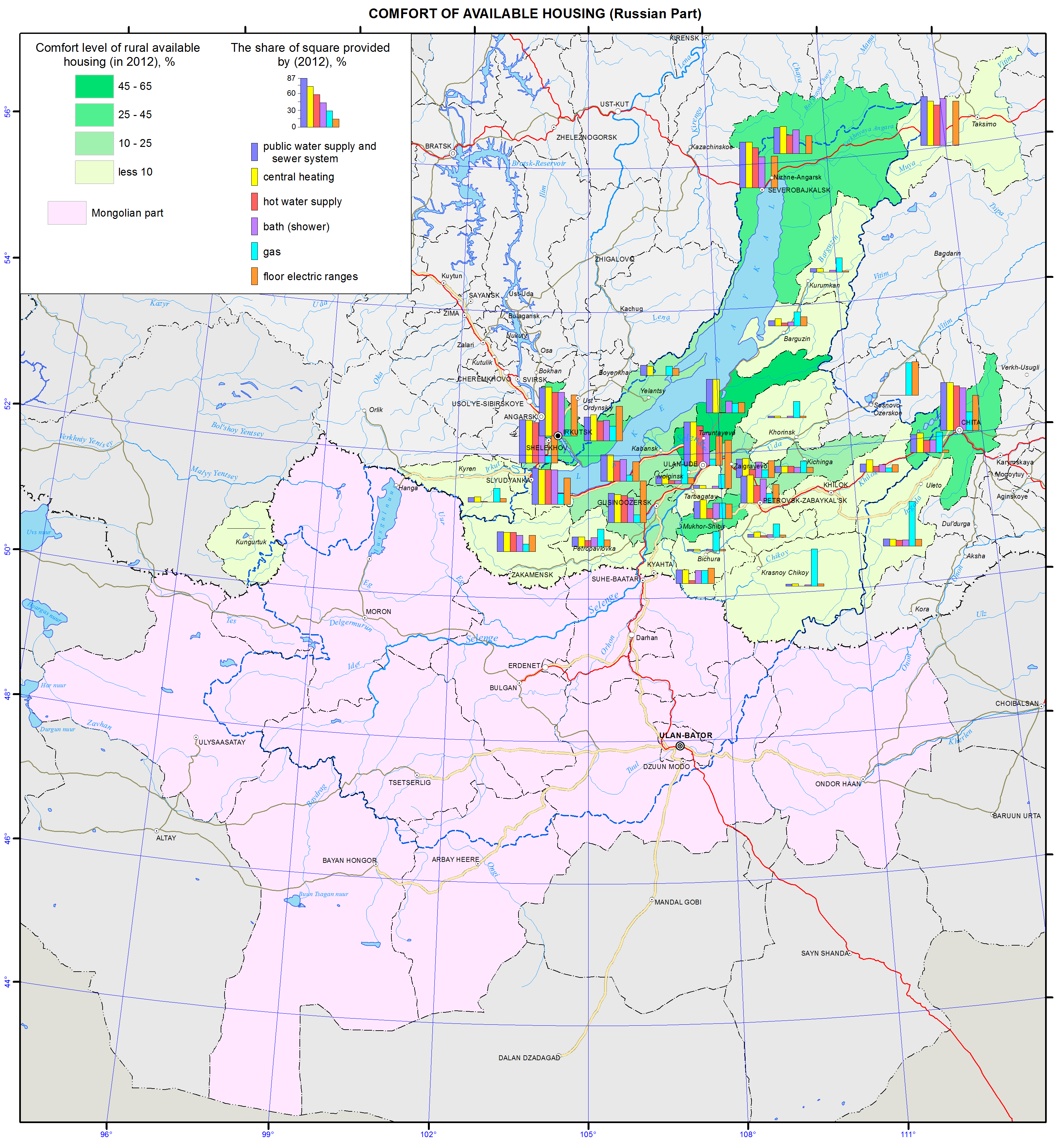
<p>The share of housing properties with urban amenities is an important factor for ecological well-being of the Baikal basin. Russian statistical data identify the following components of urban amenities: running water, sewage, central heating, hot water supply, baths (showers), and gas and electric stoves. According to the current statistical regulations, all housing properties today are considered to be equipped with central heating irrespectively of the source of heat supply (heat and electric power plant, industrial or local boiler plants, individual boilers). As a rule, the characteristics of the degree of provision with urban amenities is calculated using relative indicators – a percentage of the area of housing properties equipped with the above listed amenities compared to the total area of the housing fund (in %).</p>
<p>Spatial differences in the comfort level are quite significant in the region. Such regional centres as Irkutsk, Chita, and Ulan-Ude, as well as a town of the republican subordination Severobaikalsk have relatively high levels of urban development. However, a specific share of the housing fund equipped with urban amenities of every second administrative district of the region is less than 25%. Engineering amenities are absent in the Tere-Khol district of Tuva, Yeravna District of Buryatia (except for gas and electric stoves), and Olkhon district of Irkutsk oblast (indicators for running water, heating, gas and electric stoves do not exceed 20%).</p>
<p>The standard indicators of engineering amenities exceed 50% only in every sixth administrative district. The leaders are the Muisky district in Buryatia (due to new housing built during the Baikal-Amur Mainline construction) and Shelekhov and Slyudyanka Districts in the industrial belt surrounding Big Irkutsk (Irkutsk oblast). Almost half of the housing in three more districts has water supply, sewage and central heating: the Severobaikalsk and Kabansk districts in the Republic of Buryatia and the Irkutsk district in Irkutsk oblast.</p>
<p>Rural housing of the region has the lowest indicators of the degree of provision with urban amenities. The map shows the degree of availability of engineering amenities in rural settlements in administrative districts split into four conventionally identified groups according to the first four amenity indicators (i.e., without gas and electric stoves, as it will artificially improve the situation). In every second rural district, less than 10% of housing facilities are equipped with water supply, sewage, central heating, and baths (4<sup>th</sup> group). In five districts, this indicator is 10-25% (3<sup>rd</sup> group) (an average level for the region, but two times lower than the average for rural areas of the SFD): the Zaigraevsky, Ivolginsky, Kabansky and Kizhingsky districts in the Republic of Buryatia and Chita district in Zabaikalsky krai. The leader is the Pribaikalsky district of the Republic of Buryatia (1<sup>st</sup> group: 45-65 %, which is close to the average indicator of the SFD). This district is followed by three other districts with relatively high levels of development of the rural housing fund: the Severobaikalsky and Selenginsky districts in the Republic of Buryatia and the Irkutsk district in Irkutsk oblast (2<sup>nd</sup> group).</p>
<p>The analysis of indicators of housing development (as of 2012) in the administrative districts of the Russian part of the Baikal basin demonstrates a very low level of modern housing development, high contrasts between urban and rural settlements, and an extremely low level of comfort of rural territories.</p>
<p> </p>
<p align="center">References</p>
<p>Statistical Compendium. (2013). <i>Housing and communal services of Zabaikalsky krai</i>. Chita: Zabaikalkraistat. p 112.</p>
<p>Statistical Compendium. (2013). <i>Housing and communal services of the Irkutsk oblast in 2012</i>. Irkutsk: Irkutskstat, 2013. p 76.</p>
<p>Statistical Compendium. (2013). <i>Housing services of the Republic of Buryatia</i>. Ulan-Ude: Buryatstat. p 35.</p>]]></content:encoded>
    <dc:publisher>No publisher</dc:publisher>
    <dc:creator>Alexander Ayurzhanaev</dc:creator>
    <dc:rights></dc:rights>
    <dc:date>2014-10-09T07:05:00Z</dc:date>
    <dc:type>Page</dc:type>
  </item>


  <item rdf:about="http://bic.iwlearn.org/en/atlas/atlas/77-housing-conditions-map-1/housing-conditions-map">
    <title>Housing conditions map</title>
    <link>http://bic.iwlearn.org/en/atlas/atlas/77-housing-conditions-map-1/housing-conditions-map</link>
    <description></description>
    <content:encoded xmlns:content="http://purl.org/rss/1.0/modules/content/"><![CDATA[<p><img class="image-inline" src="../../../resolveuid/266abffde1814cdfabfc19269b5171ad/@@images/image/preview" /></p>
<p><a href="http://bic.iwlearn.org/en/atlas/photos/copy_of__77_HousingConditions.png" class="internal-link">Open full size</a></p>
<p align="center"><strong>Housing</strong></p>
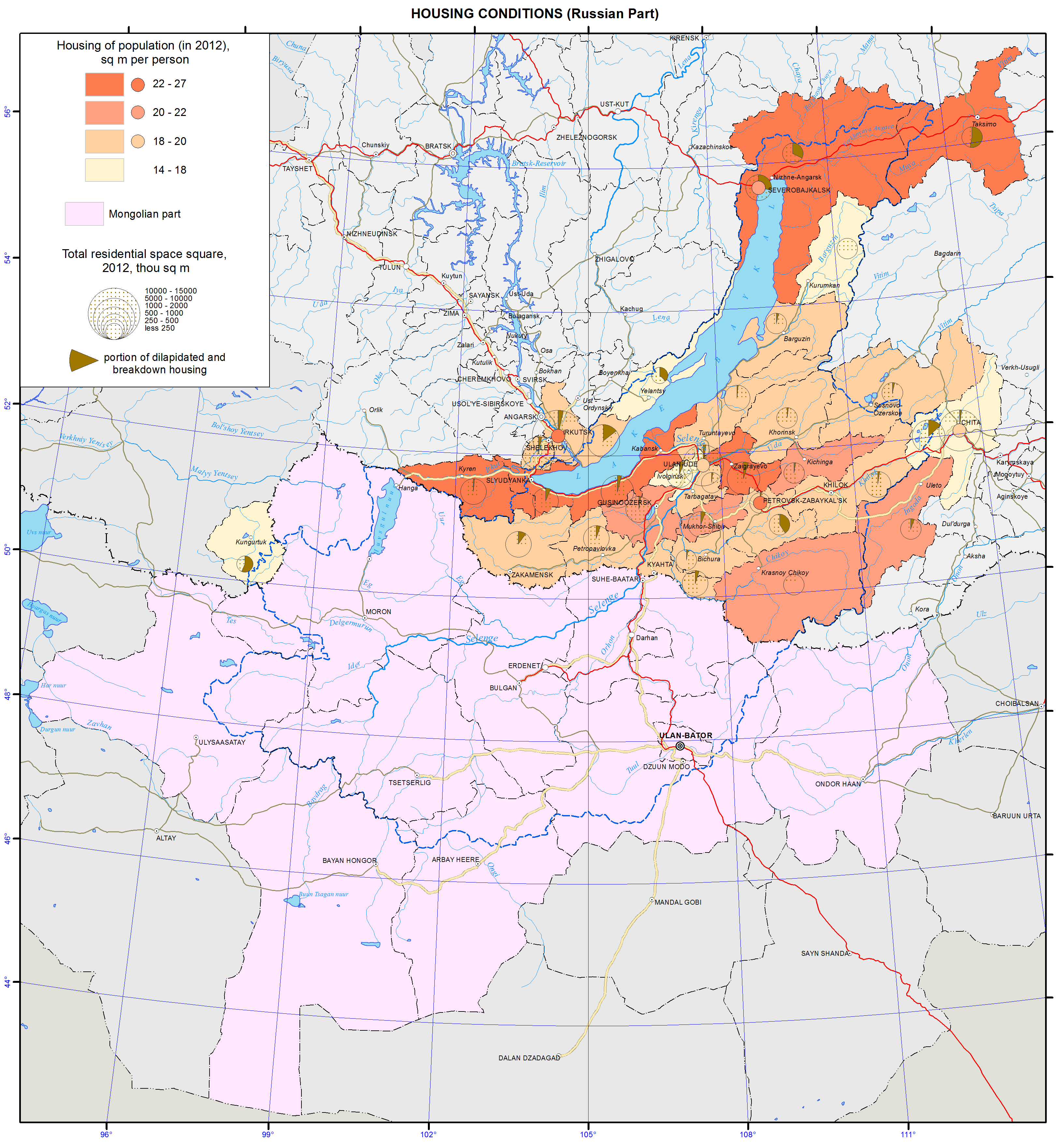
<p>The most important indicator of the quality of modern life is the character of living conditions (“roof over head”), which combines a specific indicator of housing supply and an especially important from the ecological standpoint specific indicator of the meterage of old and dilapidated housing. The main information resources used for calculations included the data of the territorial bodies of the Federal State Statistics Service of Irkutsk oblast, the Republics of Buryatia and Tuva, and Zabaikalsky krai, as well as online resources.</p>
<p>Spatial differences in the living conditions in the low-level administrative divisions (district municipalities) and urban settlements (urban municipalities) are represented by: a) a total indicator and b) a specific per capita (m²/person) indicator. According to Russian definitions, a housing fund is a collection of all housing properties regardless of the forms of ownership including residential properties, special properties (hostels, shelters, temporary public housing, nursery homes for lonely seniors, orphanages, boarding homes for persons with disabilities and veterans, and boarding schools), apartments, residential properties of businesses, and other residential properties in buildings suitable for residence. Meanwhile, the housing fund does not include residential properties of the cottage-recreational complex, i.e. summer cottages, sports and tourist facilities, rest homes and other. It should be noted that the total area of residential buildings does not include communal space (stairwells, elevator lobbies, common corridors, lobbies and other), as well as non-residential space occupied by any institutions.</p>
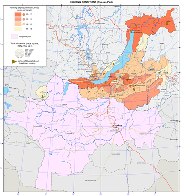
<p>The background of the map is the per capita housing supply in administrative districts and cities. The cartogram shows a specific provision of the population with housing in district municipalities and urban entities. This rate for all four subjects of Russia in the basin is much lower than both the Russian and Siberian Federal District (SFD) averages (23.4 m²/person and 22.1 m²/person, respectively).</p>
<p>Spatial differences in the region according to this indicator of housing conditions are quite sharp (a two-fold difference between the minimum and maximum values – 14.1 and 29.9 m²/person (in the Tere-Khol district of the Republic of Tuva and the Zaigraevsky district in the Republic of Buryatia, respectively). Among urban settlements, Petrovsk-Zabaikalsky has the highest per capita rate of housing provision – 23.4 m²/pers., which equals to the average Russian indicators (2012), while the outsider is Chita (19.9 m²/person).</p>
<p>In terms of specific housing supply, all district and urban entities in the region are divided into four groups taking into account the average index for the SFD ( 22.1 m²/person). The category of high-status areas (Group 1 with more than 22.1 m²/person) includes slightly over 20% of the total number of territories. Thus, almost 4/5 of municipalities of the district and city levels in the Baikal basin belong to the areas, where a specific housing supply indicator is lower than the average for the SFD.</p>
<p>The housing fund in the Baikal basin is 46.8 million m² (2012). More than two fifths of it belong to the Republic of Buryatia (41.3 %), about two fifths to the Irkutsk oblast (37.5%), and more than one fifth to the Zabaikalsky krai (21.5%), while the contribution of Tuva is only 0.1%. The urban sector predominates – more than 3/4 (75. 8%). In the Baikal basin’s regions, this picture is highly contrasting: in Irkutsk oblast the share of the urban housing fund exceeds 9/10 (90.7%), while in the neighboring Republic of Buryatia it is less than 2/3 (59.8%).</p>
<p>The share of old and dilapidated housing is an indicative negative indicator of the quality of the housing fund. It represents a total share of more than 5% (this indicator has increased manifold in comparison with 1990).</p>
<p> </p>
<p align="center">References</p>
<p>Statistical Compendium. (2013). <i>Housing and utilities of Zabaikalsky krai</i>. Chita: Zabaikalkraistat. p 112.</p>
<p>Statistical Compendium. (2013). <i>Housing and utilities of Irkutsk oblast in 2012</i>. Irkutsk: Irkutskstat. p 76.</p>
<p>Statistical Compendium. (2013). <i>Housing of the Republic of Buryatia</i>. Ulan-Ude: Buryatstat. p 35.</p>
<p>Statistical Compendium. (2013). <i>Districts of the Republic of Buryatia</i>. Ulan-Ude: Buryatstat. p 102.</p>
<p>Federal State Statistics Service. <i>Database of municipal indicators</i>. Retrieved from http://www.gks.ru/dbscripts/munst/munst.htm</p>]]></content:encoded>
    <dc:publisher>No publisher</dc:publisher>
    <dc:creator>Alexander Ayurzhanaev</dc:creator>
    <dc:rights></dc:rights>
    <dc:date>2014-10-09T06:55:00Z</dc:date>
    <dc:type>Page</dc:type>
  </item>


  <item rdf:about="http://bic.iwlearn.org/en/atlas/atlas/76-net-migration-rate-map/net-migration-rate-map">
    <title>Net migration rate map</title>
    <link>http://bic.iwlearn.org/en/atlas/atlas/76-net-migration-rate-map/net-migration-rate-map</link>
    <description></description>
    <content:encoded xmlns:content="http://purl.org/rss/1.0/modules/content/"><![CDATA[<p><img class="image-inline" src="../../../resolveuid/4d4641d334934b2b87c9198f3643ef38/@@images/image/preview" /></p>
<p><a href="http://bic.iwlearn.org/en/atlas/photos/copy_of__76_Netmigrationrate.png" class="internal-link">Open full size</a></p>
<p align="center"><strong>Population</strong></p>
<p>The population maps focus on current patterns of the settlement and demographic situation in the Baikal basin. They relate to a complex of underlying social, economic and ecological factors.</p>
<p>The population maps of the Baikal basin are based on the statistical data of the Federal State Statistics Service of the Russian Federation and National Statistical Office of <em>Mongolia</em>. Also important were the data from population censuses of Russia and Mongolia and the data of the current measurements of demographic events. The authors used statistical sources to calculate indicators for territories included into the Baikal basin.</p>
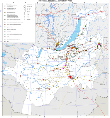
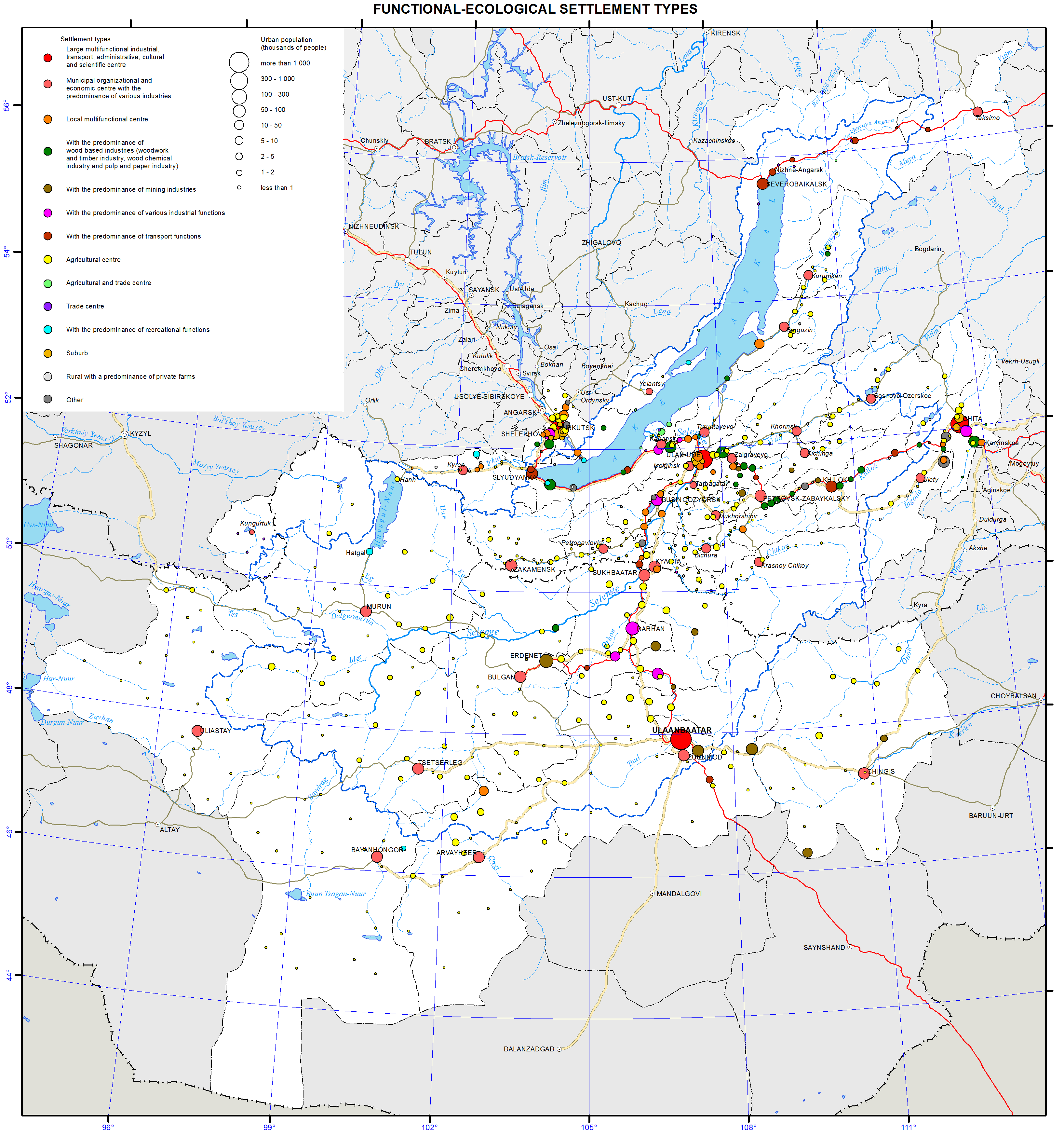
<p>The distribution of settlements within the Baikal basin is quite irregular. There are four locations of the regional concentration of the population. In Irkutsk oblast, the main settlement belt along the Trans-Siberian Railway stretches from the western border of the region up to Lake Baikal. Here, there are many agricultural settlements and the majority of large administrative and economic centers, where manufacturing sector dominates the economy. Irkutsk – a large multi-functional center – tops the group of these settlements. Only sparsely populated the Olkhon and Slyudyanka districts and part of the Irkutsk district fully lie within the Baikal basin. In the direct vicinity of Lake Baikal, but in the Angara basin, there are cities of Irkutsk and Shelekhov. In the Republic of Buryatia, there is a major settlement area around Ulan-Ude with a maximum concentration to the south of the city. Geographic differences in the specialization of settlements have emerged. Settlements involved in manufacturing and transportation are overwhelmingly dominant along the Trans-Siberian Railway. In Southern Buryatia, there are mostly agricultural settlements. In Zabaikalsky krai, there are three settlement networks: settlements involved in manufacturing and transportation located along the railway; mining settlements near deposits; and agricultural settlements located south of Chita in the forest-steppe and steppe zone. In Mongolia, the population is mainly concentrated in the central region – from Ulaanbaatar in the south to Sukhbaatar in the north. Three largest cities of the country and more than a half of its population are located in this area. The other territories of the Mongolian part of the Baikal basin are sparsely populated.</p>
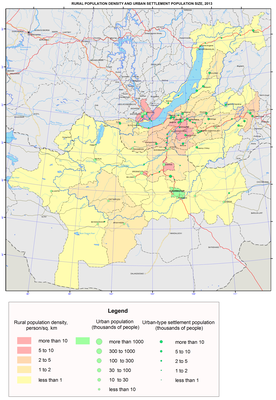
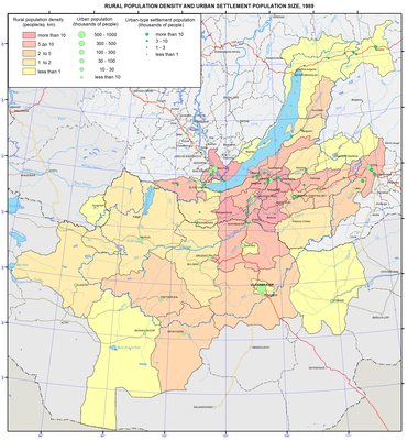
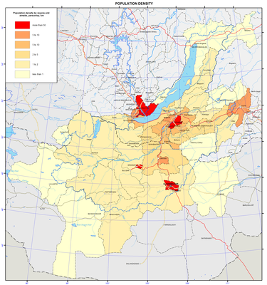
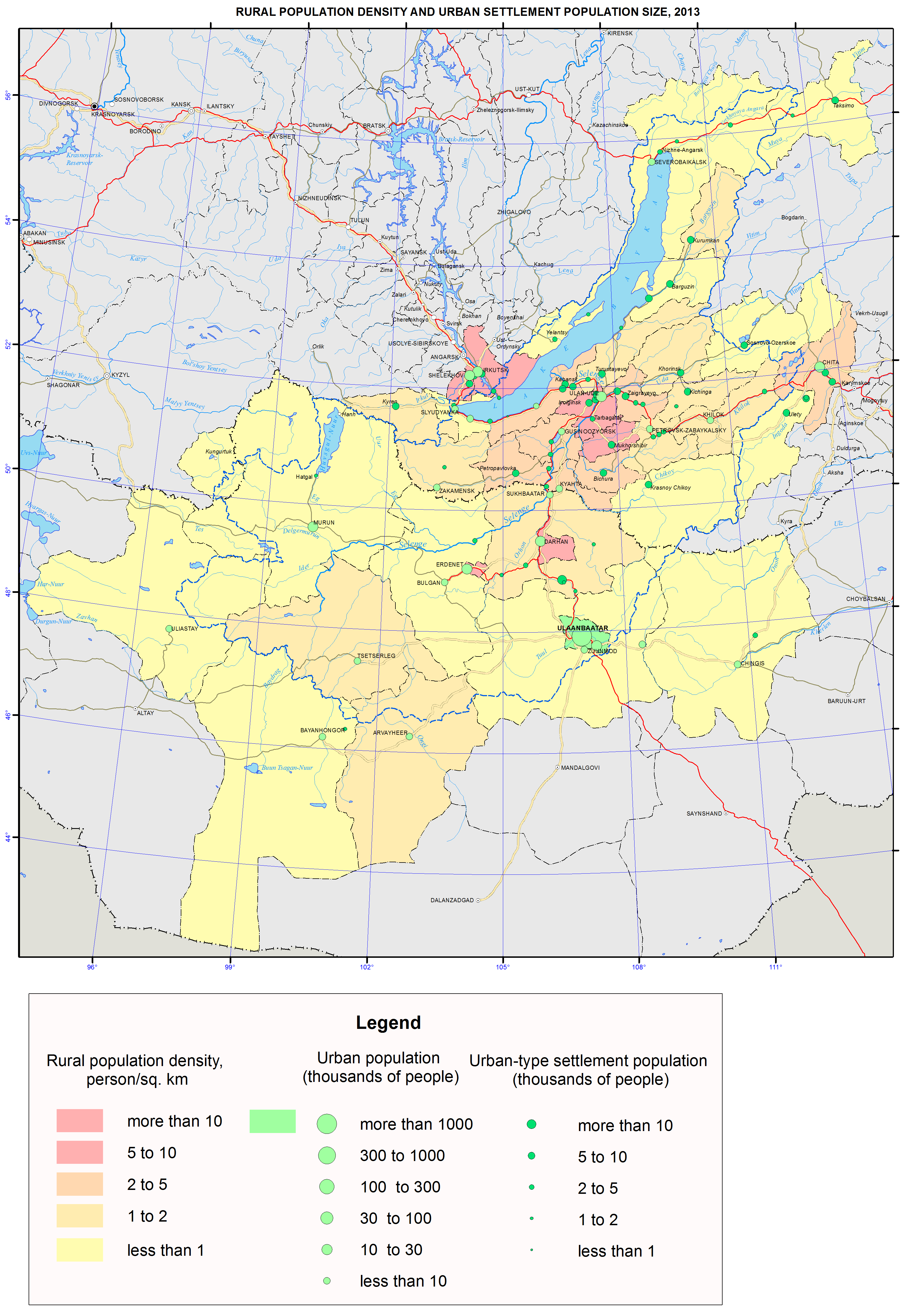
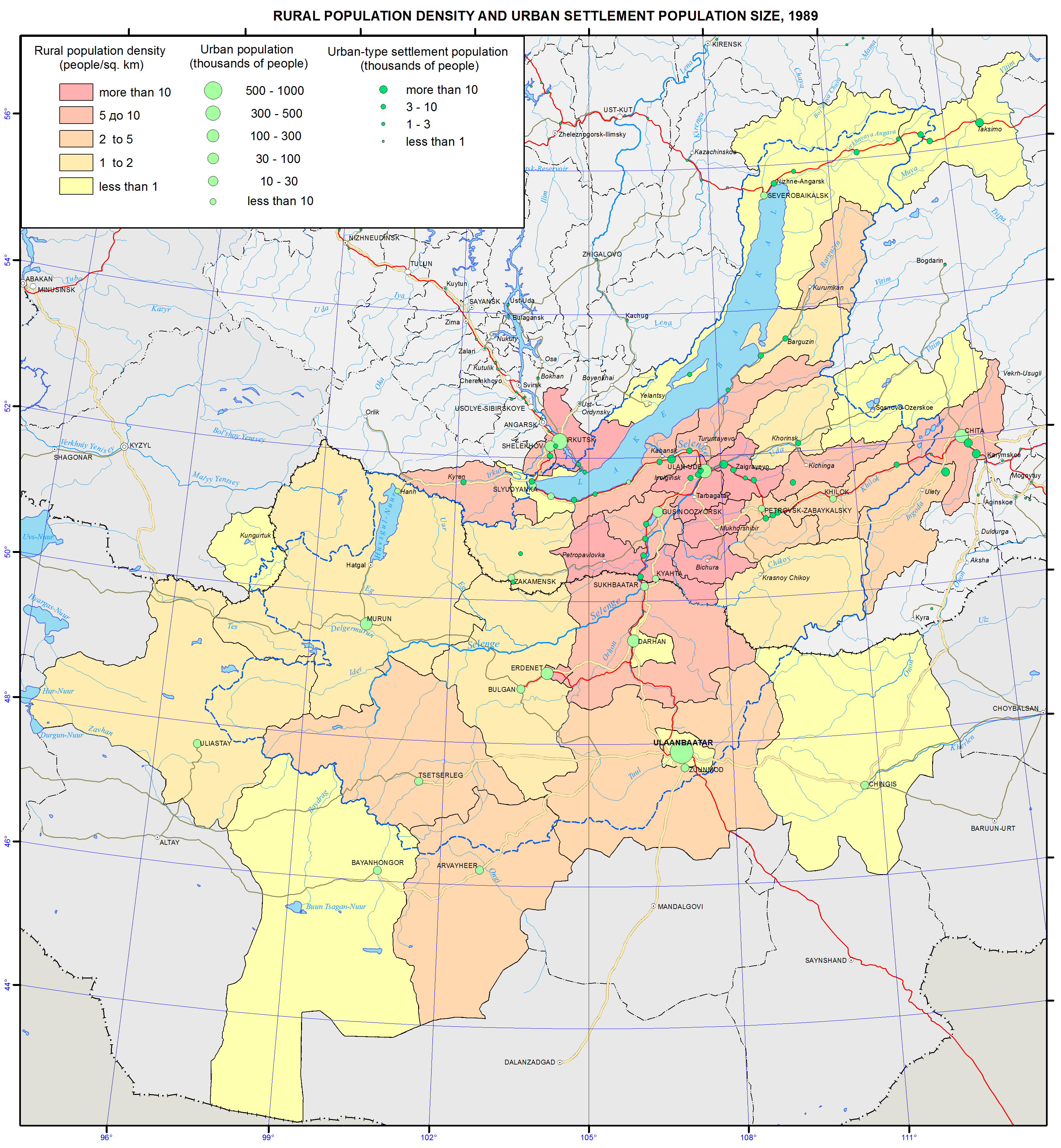
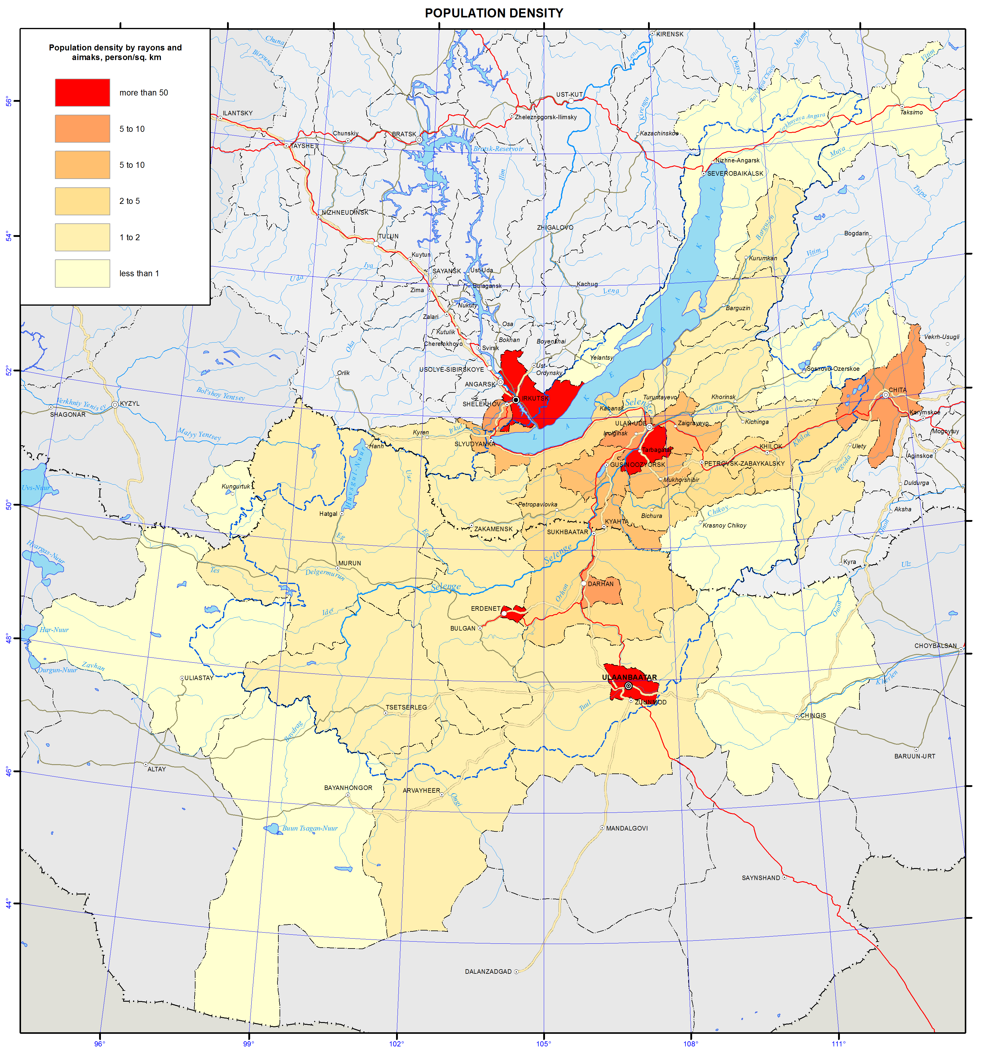
<p>Distribution of the population and the degree of the settlement of the territory are displayed on the maps “Density of population (as of 1.1.2013)”; “Density of rural population and population size of urban settlements (as of 1.1.1989)”; “Density of rural population and population size of urban settlements (as of 1.1.2013)”.</p>
<p>The Baikal region belongs to sparsely and unevenly populated territories. The population density of the Baikal basin is 17 times lower than the world’s average of 53 persons/km<sup>2</sup>. The population density in the Russian part of the basin is 2.9 persons/km<sup>2</sup>, which is nine times lower than in the European part of Russia (26 persons/km<sup>2</sup>).</p>
<p>The intra-regional differentiation of settlement patterns is stipulated by several spatial gradients of the population density decrease, with the main gradient leading from the center (capitals and administrative centers) to the periphery. Other gradients are also present in particular territories. Thus, in the Russian part of the basin, the population density tends to decrease as it goes from the south to the north and from the west to the east. The Russian-Mongolian border for the most part rather separates than unites the areas of settlement, except for one direction. The core of this direction is the Selenga Valley, where an area with a highly dense population has formed between Ulaanbaatar and Ulan-Ude.</p>
<p>The territories around large cities, like the regional centers Irkutsk, Ulan-Ude and Chita, are most densely populated. Along with the areas with dense population, there are also virtually unpopulated territories of tens of thousands square kilometers in area. The distribution of rural population is less contrasting than the urban one. The main clusters of rural population are located in the forest-steppe and steppe zones, where the density of population may reach 10-20 persons/km<sup>2</sup>. Rural population is mainly concentrated in the south of Irkutsk oblast (around Irkutsk) and in the central part of Buryatia (south of Ulan-Ude).</p>
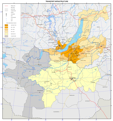
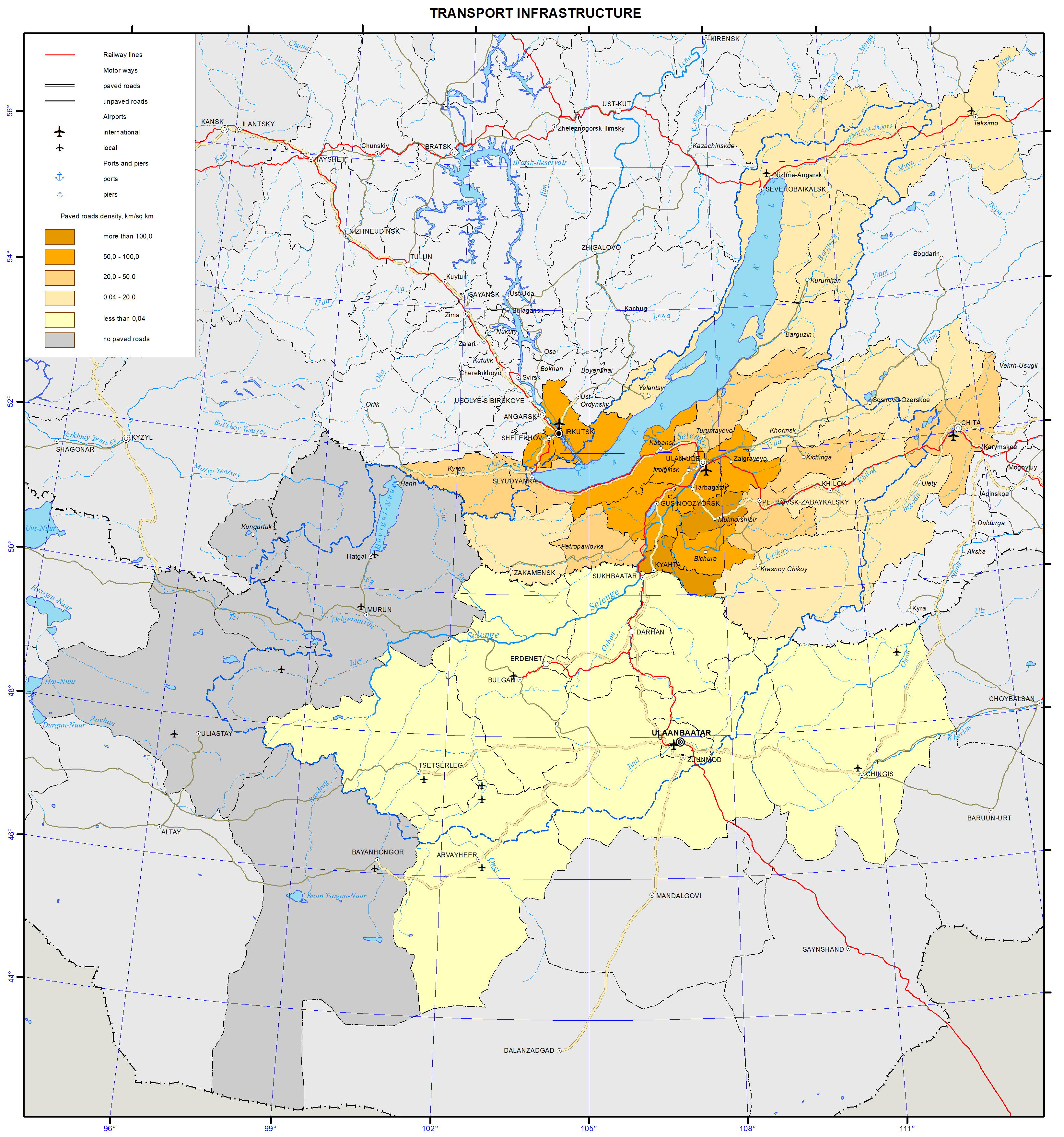
<p>The major cities of the Russian part of the basin grew along the transportation lines. Thus, 11 out of 13 towns are located along the railways. Only Zakamensk and Kyakhta are located away from the railroad. In the Mongolian part of the basin, the connection of urban settlements to transportation lines is less pronounced with only five out of 12 towns being situated on the railways.</p>
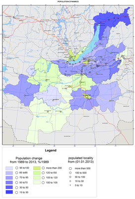
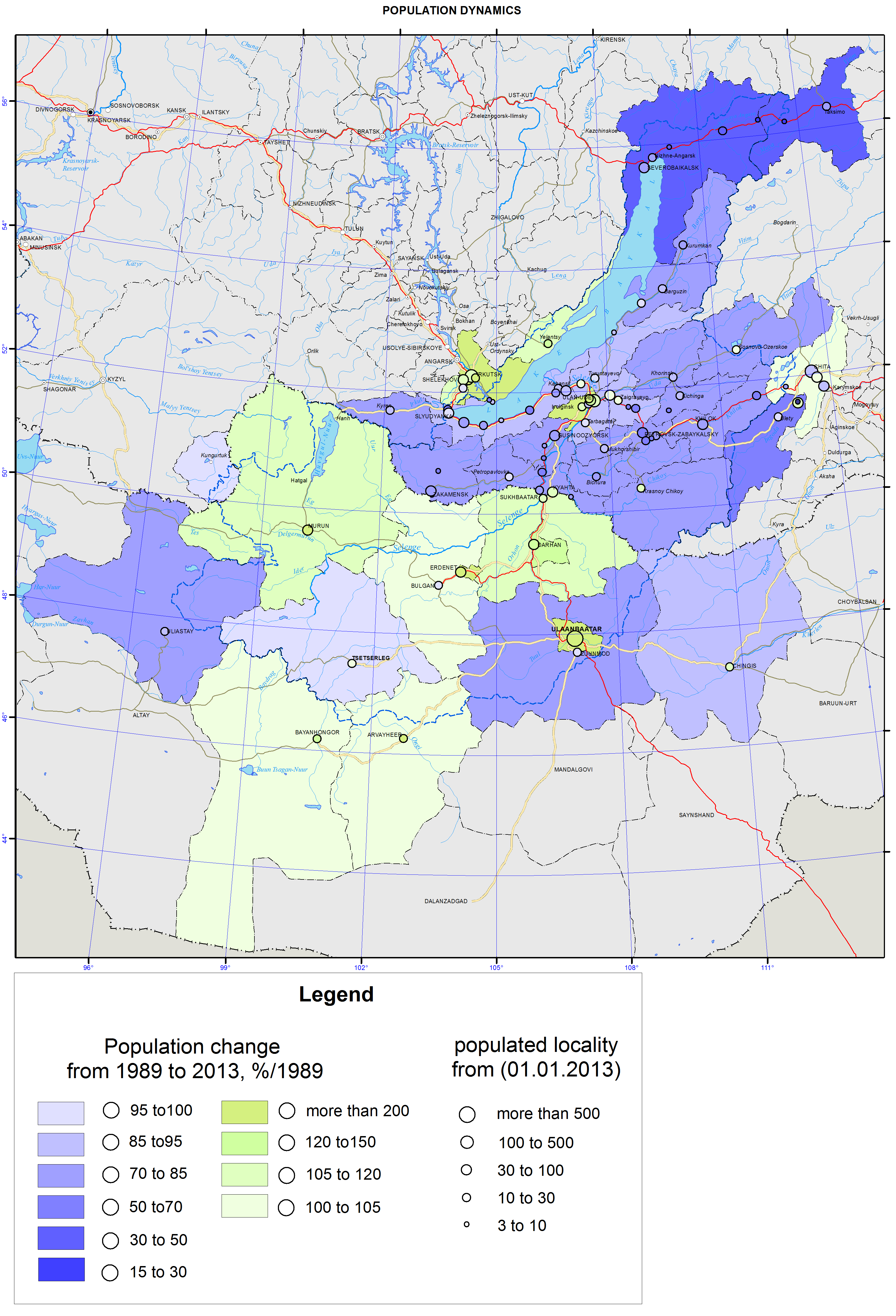
<p>The map “Dynamics of the population size (1989-2013)” shows considerable changes in the population size – a situation, where a high concentration of the population in a few largest centers is followed by depopulation of vast territories.</p>
<p>In the Russian part of the basin, there were two clear patterns of the population size dynamics from 1989 to 2013. Firstly, the decrease of population tends to be more pronounced from the southwest to the northeast. Secondly, the population dynamics in regional centers (Irkutsk, Ulan-Ude, and Chita) and their suburbs is relatively positive. Population growth is observed only in the Irkutsk, Shelekhov, and Olkhon districts of Irkutsk oblast, Ivolga district of the Republic of Buryatia and Chita district of Zabaikalsky krai. The record level growth of population (over 160 %) was recorded in the suburban Ivolginsky and Irkutsk districts. The biggest drop in the population takes place in the localities that are classified as districts of the Far North, with the Muisky and Severobaikalsky districts of the Republic of Buryatia loosing over half of their population.</p>
<p>In the Mongolian part of the Baikal basin, population growth is registered on over a half of the nation’s territory. The main Mongolian cities – Ulaanbaatar, the capital of Mongolia, (244 % to the level of 1989), Erdenet, and Darkhan are the fastest growing cities. The Khovsgol and Selenga aimags also demonstrate a significant growth of population. The population in the four aimags of Arkhangai, Zavkhan, Tov, and Khentei decreases due to an outward migration of residents.</p>
<p>The contrasting nature of the population dynamics within the Baikal basin is quite distinct:</p>
<p>– The Russian part of the Baikal basin is characterized by the type of the population dynamics, where an outward migration is several times higher than a natural population decline;</p>
<p>–        The Mongolian part is characterized by the type of the population dynamics, where a natural increase of population prevails over inward migration.</p>
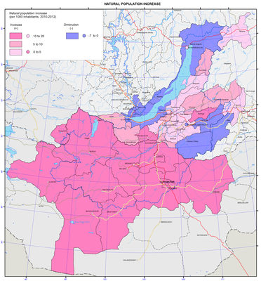
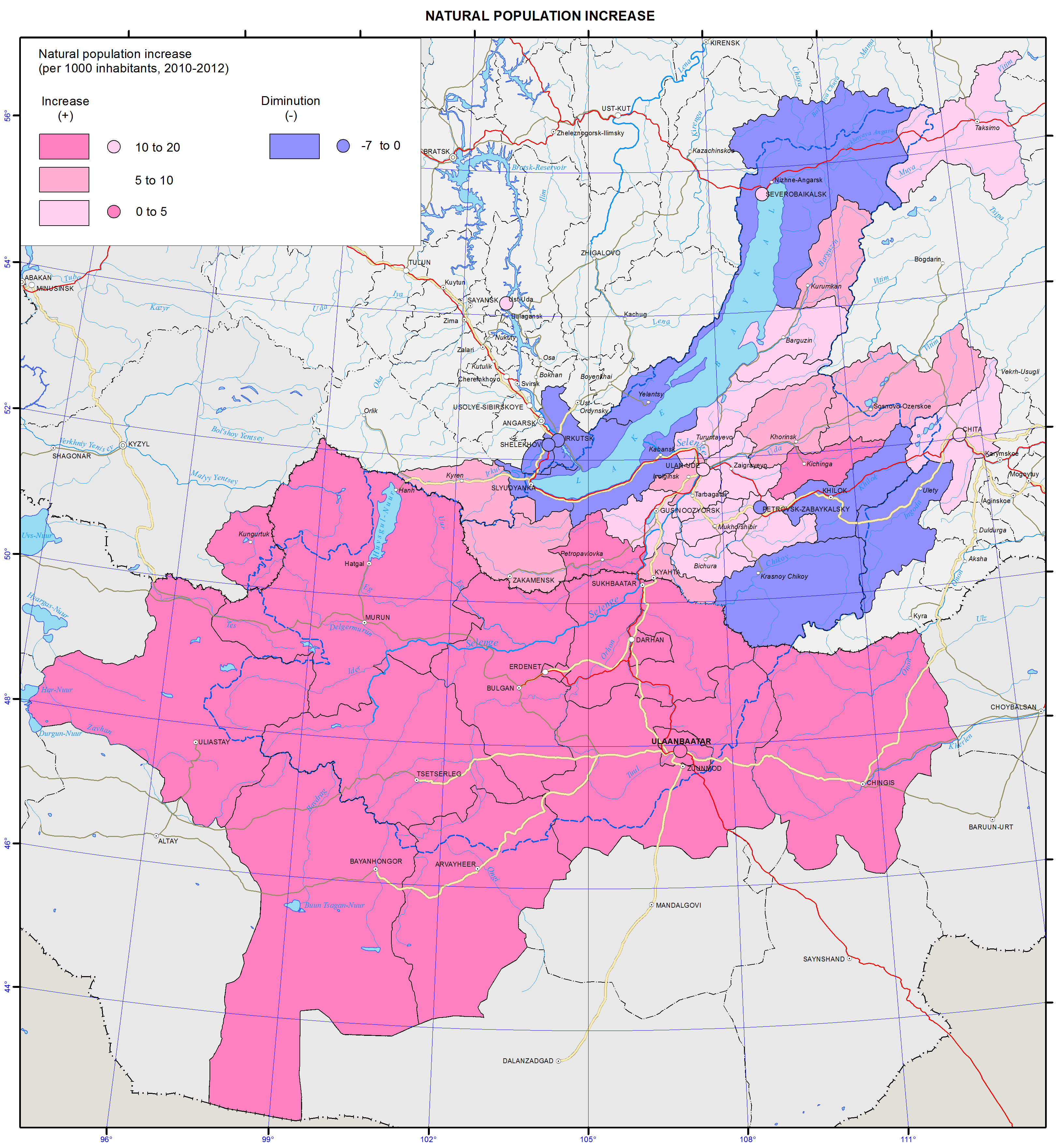
<p>Territorial specifics of demographic development are shown on the map “Natural increase of population”.</p>
<p>In the Baikal basin, different modes of reproduction of population exist along with a wide variety of quantitative parameters of demographic processes. In general, it is possible to identify two types of population reproduction. Thus, all of Mongolia, Tuva and part of Buryatia are characterized by an expanded type of reproduction with high birth rates, average mortality, and a significant natural growth. The Baikal region of Irkutsk oblast, Zabaikalsky krai, and most of Buryatia is characterized by a narrow type of reproduction with low birth rates, high mortality, and a natural population decline or insignificant natural growth. The annual natural growth of the population in Mongolian aimags is 17-19%. In the Russian part of the basin, natural movement of the population led to mixed results, where 23 municipalities showed population increase, while 10 municipalities had natural decline. With an average natural population increase of 1.4 per mille, there were significant variations – from the decline ranging from -5 to -6% (in the Petrovsk-Zabaikalsky, Irkutsk and Olkhon districts) to the increase exceeding 10 pro mille (10.4% in the Dzhida district, 12.1% in the Kizhinga District, and 16.0% in the Tere-Khol district). The natural population increase in the Mongolian capital Ulaanbaatar was 17.2%, while the increase in the Russian regional centers Ulan-Ude and Chita was 4.3% and 3.4%, respectively, with the decline of -2.7 % in Irkutsk.</p>
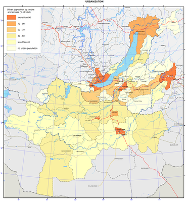
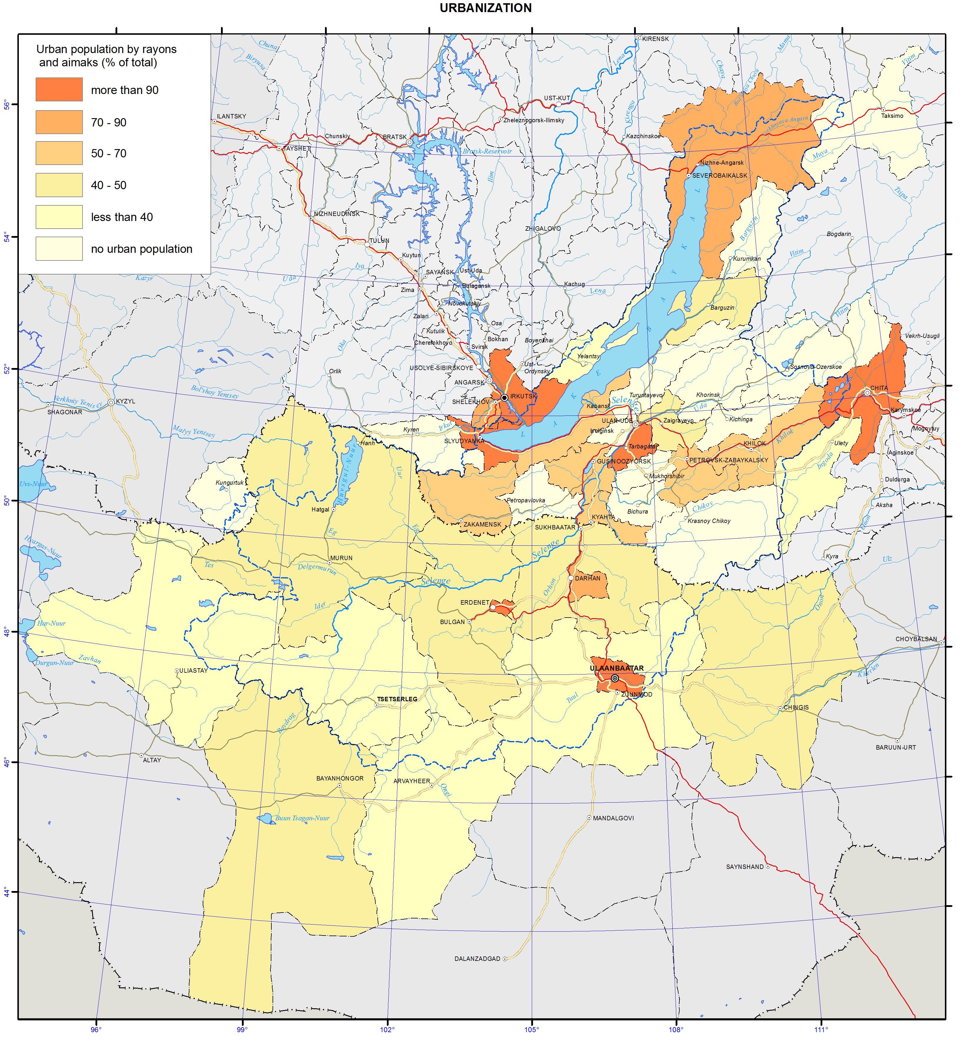
<p>The map “Urbanization of the territory” shows the proportion of urban population in Russian municipal districts and Mongolian aimags. The share of urban population exceeds 74% of the entire population and is composed of a few territories. The level of the urbanization of the population exceeds the world’s average (51%) by nearly one and half times, however, the level of the urbanization of the territory is low. Urban territories mainly include settlements located along the railways, as well as densely populated administrative centers. In the Mongolian part of the Baikal basin, only Ulaanbaatar and the Orkhon and Darkhan-uul aimags are highly urbanized, while the remaining nine aimags have only a small share of urban population (17.5%-34.9 %). In Mongolia, administrative centers of every aimag must be urban settlements. However, in Russia, the legislation does not mandate municipalities to have urban settlements. Therefore, in the Russian part of the basin, as of 2013, 14 districts did not have urban population at all. Some settlements (Barguzin, Ivolginsk, Kyren, and Khorinsk) rejected their urban status in the process of municipal reforms of the 2000s. The population of Mongolian towns within the basin nearly doubled in 1989-2013, with the population of Ulaanbaatar growing from 540.6 to 1,318.1 thousand people. The population of the largest cities in the Russian part of the basin did not change that much: in Irkutsk, it grew from 572.4 to 606.1 thousand people, in Ulan-Ude – from 352.5 to 416.1, while in Chita it declined from 365.8 to 331.3 thousand people.</p>
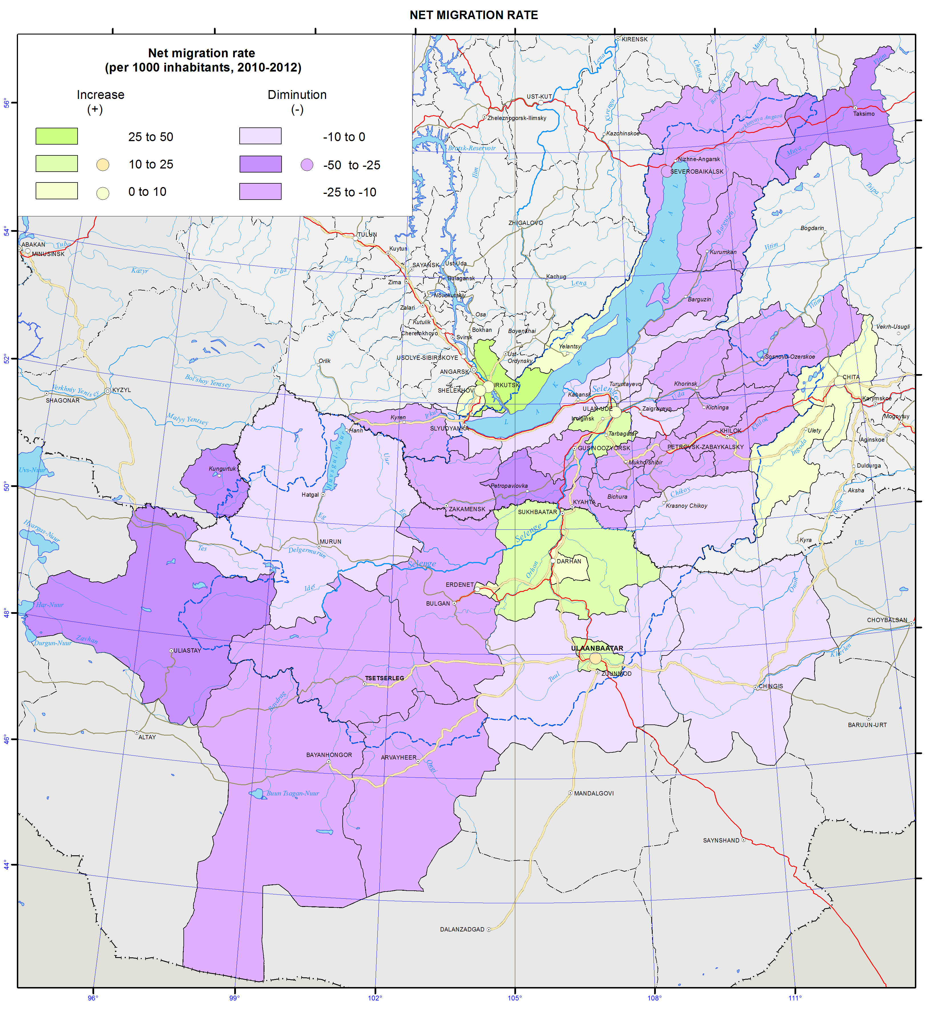
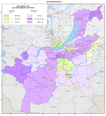
<p>The main results of migration processes in 2010-2012 are shown on the map “Migratory increase of population”.</p>
<p>In Russia, including the Baikal basin, the last two decades witnessed a significant decrease of migration activity of the population. However, outward migration from the region remains high and reproduces almost annually from the mid-1990s up to now. Population movement has mostly become intra-regional – the intra-regional migration turnover makes about 2/3 of relocations in the Baikal basin. The intra-Russian interregional migration causes migration losses, while migratory relationships with the CIS countries contribute to a considerable growth of population.</p>
<p>Redistribution of the population between the constituent parts of the Baikal region is intensive including some tens of thousands people annually. In 2010-2012, on average 66.5 thousand people arrived, and 58.6 thousand left. In the Baikal region, the average annual migration increment was 7.9 thousand people. However, it was due to the growth in the attractive for migrants cities of Irkutsk and the Irkutsk district (+9.3 thousand people), Ulan-Ude (+3.4 thousand people) and Chita (+2.9 thousand people). The total growth of the population in these cities was 15.6 thousand people. The rest of the region experienced the outflow of residents totaling 7.7 thousand people. Migration redistribution leads to the growth of the population in regional centers and their suburbs. Only 10 municipalities had a migratory growth, while the rest 24 showed a decline. The intensity of migrant arrivals is highest (twice as high as average) in the suburban Irkutsk and Ivolginsky districts, while the intensity of departures is highest (twice as high as average) in the undeveloped Dzhida, Kizhinga and Muisky districts. Against this backdrop, the Russian part of the Baikal basin has two migration poles – the Irkutsk and Dzhida districts, where an average annual migration balance is +47.4% and -46.0%, accordingly.</p>
<p>In general, the majority of territories is characterized by a progressive outward migration, which is compounded by unfavorable structural features of the outflow (with young and educated groups of people leaving the region). The results of migration movement are clearly expressed in terms of the center-periphery relationship: there are three areas of migration growth in the Russian part of the basin (Irkutsk, Ulan-Ude, and Chita with their suburban districts) and one in the Mongolian part, which combines the capital Ulaanbaatar and the aimags lying to the north of it –  Selenge, Orkhon, and Darkhan.</p>]]></content:encoded>
    <dc:publisher>No publisher</dc:publisher>
    <dc:creator>Alexander Ayurzhanaev</dc:creator>
    <dc:rights></dc:rights>
    <dc:date>2014-10-09T06:50:00Z</dc:date>
    <dc:type>Page</dc:type>
  </item>


  <item rdf:about="http://bic.iwlearn.org/en/atlas/atlas/77-housing-conditions-map-1">
    <title>077. Housing conditions map</title>
    <link>http://bic.iwlearn.org/en/atlas/atlas/77-housing-conditions-map-1</link>
    <description></description>
    
    <dc:publisher>No publisher</dc:publisher>
    <dc:creator>Alexander Ayurzhanaev</dc:creator>
    <dc:rights></dc:rights>
    <dc:date>2014-10-09T06:50:00Z</dc:date>
    <dc:type>Folder</dc:type>
  </item>


  <item rdf:about="http://bic.iwlearn.org/en/atlas/atlas/75-urbanization-map/urbanization-map">
    <title>Urbanization map</title>
    <link>http://bic.iwlearn.org/en/atlas/atlas/75-urbanization-map/urbanization-map</link>
    <description></description>
    <content:encoded xmlns:content="http://purl.org/rss/1.0/modules/content/"><![CDATA[<p><img class="image-inline" src="../../../resolveuid/767f6abb0c704cba970528bf2a00e734/@@images/image/preview" /></p>
<p><a href="http://bic.iwlearn.org/en/atlas/photos/copy_of__75_Urbanization.png" class="internal-link">Open full size</a></p>
<p align="center"><strong>Population</strong></p>
<p>The population maps focus on current patterns of the settlement and demographic situation in the Baikal basin. They relate to a complex of underlying social, economic and ecological factors.</p>
<p>The population maps of the Baikal basin are based on the statistical data of the Federal State Statistics Service of the Russian Federation and National Statistical Office of <em>Mongolia</em>. Also important were the data from population censuses of Russia and Mongolia and the data of the current measurements of demographic events. The authors used statistical sources to calculate indicators for territories included into the Baikal basin.</p>
<p>The distribution of settlements within the Baikal basin is quite irregular. There are four locations of the regional concentration of the population. In Irkutsk oblast, the main settlement belt along the Trans-Siberian Railway stretches from the western border of the region up to Lake Baikal. Here, there are many agricultural settlements and the majority of large administrative and economic centers, where manufacturing sector dominates the economy. Irkutsk – a large multi-functional center – tops the group of these settlements. Only sparsely populated the Olkhon and Slyudyanka districts and part of the Irkutsk district fully lie within the Baikal basin. In the direct vicinity of Lake Baikal, but in the Angara basin, there are cities of Irkutsk and Shelekhov. In the Republic of Buryatia, there is a major settlement area around Ulan-Ude with a maximum concentration to the south of the city. Geographic differences in the specialization of settlements have emerged. Settlements involved in manufacturing and transportation are overwhelmingly dominant along the Trans-Siberian Railway. In Southern Buryatia, there are mostly agricultural settlements. In Zabaikalsky krai, there are three settlement networks: settlements involved in manufacturing and transportation located along the railway; mining settlements near deposits; and agricultural settlements located south of Chita in the forest-steppe and steppe zone. In Mongolia, the population is mainly concentrated in the central region – from Ulaanbaatar in the south to Sukhbaatar in the north. Three largest cities of the country and more than a half of its population are located in this area. The other territories of the Mongolian part of the Baikal basin are sparsely populated.</p>
<p>Distribution of the population and the degree of the settlement of the territory are displayed on the maps “Density of population (as of 1.1.2013)”; “Density of rural population and population size of urban settlements (as of 1.1.1989)”; “Density of rural population and population size of urban settlements (as of 1.1.2013)”.</p>
<p>The Baikal region belongs to sparsely and unevenly populated territories. The population density of the Baikal basin is 17 times lower than the world’s average of 53 persons/km<sup>2</sup>. The population density in the Russian part of the basin is 2.9 persons/km<sup>2</sup>, which is nine times lower than in the European part of Russia (26 persons/km<sup>2</sup>).</p>
<p>The intra-regional differentiation of settlement patterns is stipulated by several spatial gradients of the population density decrease, with the main gradient leading from the center (capitals and administrative centers) to the periphery. Other gradients are also present in particular territories. Thus, in the Russian part of the basin, the population density tends to decrease as it goes from the south to the north and from the west to the east. The Russian-Mongolian border for the most part rather separates than unites the areas of settlement, except for one direction. The core of this direction is the Selenga Valley, where an area with a highly dense population has formed between Ulaanbaatar and Ulan-Ude.</p>
<p>The territories around large cities, like the regional centers Irkutsk, Ulan-Ude and Chita, are most densely populated. Along with the areas with dense population, there are also virtually unpopulated territories of tens of thousands square kilometers in area. The distribution of rural population is less contrasting than the urban one. The main clusters of rural population are located in the forest-steppe and steppe zones, where the density of population may reach 10-20 persons/km<sup>2</sup>. Rural population is mainly concentrated in the south of Irkutsk oblast (around Irkutsk) and in the central part of Buryatia (south of Ulan-Ude).</p>
<p>The major cities of the Russian part of the basin grew along the transportation lines. Thus, 11 out of 13 towns are located along the railways. Only Zakamensk and Kyakhta are located away from the railroad. In the Mongolian part of the basin, the connection of urban settlements to transportation lines is less pronounced with only five out of 12 towns being situated on the railways.</p>
<p>The map “Dynamics of the population size (1989-2013)” shows considerable changes in the population size – a situation, where a high concentration of the population in a few largest centers is followed by depopulation of vast territories.</p>
<p>In the Russian part of the basin, there were two clear patterns of the population size dynamics from 1989 to 2013. Firstly, the decrease of population tends to be more pronounced from the southwest to the northeast. Secondly, the population dynamics in regional centers (Irkutsk, Ulan-Ude, and Chita) and their suburbs is relatively positive. Population growth is observed only in the Irkutsk, Shelekhov, and Olkhon districts of Irkutsk oblast, Ivolga district of the Republic of Buryatia and Chita district of Zabaikalsky krai. The record level growth of population (over 160 %) was recorded in the suburban Ivolginsky and Irkutsk districts. The biggest drop in the population takes place in the localities that are classified as districts of the Far North, with the Muisky and Severobaikalsky districts of the Republic of Buryatia loosing over half of their population.</p>
<p>In the Mongolian part of the Baikal basin, population growth is registered on over a half of the nation’s territory. The main Mongolian cities – Ulaanbaatar, the capital of Mongolia, (244 % to the level of 1989), Erdenet, and Darkhan are the fastest growing cities. The Khovsgol and Selenga aimags also demonstrate a significant growth of population. The population in the four aimags of Arkhangai, Zavkhan, Tov, and Khentei decreases due to an outward migration of residents.</p>
<p>The contrasting nature of the population dynamics within the Baikal basin is quite distinct:</p>
<p>– The Russian part of the Baikal basin is characterized by the type of the population dynamics, where an outward migration is several times higher than a natural population decline;</p>
<p>–        The Mongolian part is characterized by the type of the population dynamics, where a natural increase of population prevails over inward migration.</p>
<p>Territorial specifics of demographic development are shown on the map “Natural increase of population”.</p>
<p>In the Baikal basin, different modes of reproduction of population exist along with a wide variety of quantitative parameters of demographic processes. In general, it is possible to identify two types of population reproduction. Thus, all of Mongolia, Tuva and part of Buryatia are characterized by an expanded type of reproduction with high birth rates, average mortality, and a significant natural growth. The Baikal region of Irkutsk oblast, Zabaikalsky krai, and most of Buryatia is characterized by a narrow type of reproduction with low birth rates, high mortality, and a natural population decline or insignificant natural growth. The annual natural growth of the population in Mongolian aimags is 17-19%. In the Russian part of the basin, natural movement of the population led to mixed results, where 23 municipalities showed population increase, while 10 municipalities had natural decline. With an average natural population increase of 1.4 per mille, there were significant variations – from the decline ranging from -5 to -6% (in the Petrovsk-Zabaikalsky, Irkutsk and Olkhon districts) to the increase exceeding 10 pro mille (10.4% in the Dzhida district, 12.1% in the Kizhinga District, and 16.0% in the Tere-Khol district). The natural population increase in the Mongolian capital Ulaanbaatar was 17.2%, while the increase in the Russian regional centers Ulan-Ude and Chita was 4.3% and 3.4%, respectively, with the decline of -2.7 % in Irkutsk.</p>
<p>The map “Urbanization of the territory” shows the proportion of urban population in Russian municipal districts and Mongolian aimags. The share of urban population exceeds 74% of the entire population and is composed of a few territories. The level of the urbanization of the population exceeds the world’s average (51%) by nearly one and half times, however, the level of the urbanization of the territory is low. Urban territories mainly include settlements located along the railways, as well as densely populated administrative centers. In the Mongolian part of the Baikal basin, only Ulaanbaatar and the Orkhon and Darkhan-uul aimags are highly urbanized, while the remaining nine aimags have only a small share of urban population (17.5%-34.9 %). In Mongolia, administrative centers of every aimag must be urban settlements. However, in Russia, the legislation does not mandate municipalities to have urban settlements. Therefore, in the Russian part of the basin, as of 2013, 14 districts did not have urban population at all. Some settlements (Barguzin, Ivolginsk, Kyren, and Khorinsk) rejected their urban status in the process of municipal reforms of the 2000s. The population of Mongolian towns within the basin nearly doubled in 1989-2013, with the population of Ulaanbaatar growing from 540.6 to 1,318.1 thousand people. The population of the largest cities in the Russian part of the basin did not change that much: in Irkutsk, it grew from 572.4 to 606.1 thousand people, in Ulan-Ude – from 352.5 to 416.1, while in Chita it declined from 365.8 to 331.3 thousand people.</p>
<p>The main results of migration processes in 2010-2012 are shown on the map “Migratory increase of population”.</p>
<p>In Russia, including the Baikal basin, the last two decades witnessed a significant decrease of migration activity of the population. However, outward migration from the region remains high and reproduces almost annually from the mid-1990s up to now. Population movement has mostly become intra-regional – the intra-regional migration turnover makes about 2/3 of relocations in the Baikal basin. The intra-Russian interregional migration causes migration losses, while migratory relationships with the CIS countries contribute to a considerable growth of population.</p>
<p>Redistribution of the population between the constituent parts of the Baikal region is intensive including some tens of thousands people annually. In 2010-2012, on average 66.5 thousand people arrived, and 58.6 thousand left. In the Baikal region, the average annual migration increment was 7.9 thousand people. However, it was due to the growth in the attractive for migrants cities of Irkutsk and the Irkutsk district (+9.3 thousand people), Ulan-Ude (+3.4 thousand people) and Chita (+2.9 thousand people). The total growth of the population in these cities was 15.6 thousand people. The rest of the region experienced the outflow of residents totaling 7.7 thousand people. Migration redistribution leads to the growth of the population in regional centers and their suburbs. Only 10 municipalities had a migratory growth, while the rest 24 showed a decline. The intensity of migrant arrivals is highest (twice as high as average) in the suburban Irkutsk and Ivolginsky districts, while the intensity of departures is highest (twice as high as average) in the undeveloped Dzhida, Kizhinga and Muisky districts. Against this backdrop, the Russian part of the Baikal basin has two migration poles – the Irkutsk and Dzhida districts, where an average annual migration balance is +47.4% and -46.0%, accordingly.</p>
<p>In general, the majority of territories is characterized by a progressive outward migration, which is compounded by unfavorable structural features of the outflow (with young and educated groups of people leaving the region). The results of migration movement are clearly expressed in terms of the center-periphery relationship: there are three areas of migration growth in the Russian part of the basin (Irkutsk, Ulan-Ude, and Chita with their suburban districts) and one in the Mongolian part, which combines the capital Ulaanbaatar and the aimags lying to the north of it –  Selenge, Orkhon, and Darkhan.</p>]]></content:encoded>
    <dc:publisher>No publisher</dc:publisher>
    <dc:creator>Alexander Ayurzhanaev</dc:creator>
    <dc:rights></dc:rights>
    <dc:date>2014-10-09T06:10:00Z</dc:date>
    <dc:type>Page</dc:type>
  </item>


  <item rdf:about="http://bic.iwlearn.org/en/atlas/atlas/74-natural-population-increase-map/natural-population-increase-map">
    <title>Natural population increase map</title>
    <link>http://bic.iwlearn.org/en/atlas/atlas/74-natural-population-increase-map/natural-population-increase-map</link>
    <description></description>
    <content:encoded xmlns:content="http://purl.org/rss/1.0/modules/content/"><![CDATA[<p><img class="image-inline" src="../../../resolveuid/99cc30ad5f61489c9fbdba132b5425e2/@@images/image/preview" /></p>
<p><a href="http://bic.iwlearn.org/en/atlas/photos/copy2_of__74_Naturalpopulationincrease.png" class="internal-link">Open full size</a></p>
<p align="center"><strong>Population</strong></p>
<p>The population maps focus on current patterns of the settlement and demographic situation in the Baikal basin. They relate to a complex of underlying social, economic and ecological factors.</p>
<p>The population maps of the Baikal basin are based on the statistical data of the Federal State Statistics Service of the Russian Federation and National Statistical Office of <em>Mongolia</em>. Also important were the data from population censuses of Russia and Mongolia and the data of the current measurements of demographic events. The authors used statistical sources to calculate indicators for territories included into the Baikal basin.</p>
<p>The distribution of settlements within the Baikal basin is quite irregular. There are four locations of the regional concentration of the population. In Irkutsk oblast, the main settlement belt along the Trans-Siberian Railway stretches from the western border of the region up to Lake Baikal. Here, there are many agricultural settlements and the majority of large administrative and economic centers, where manufacturing sector dominates the economy. Irkutsk – a large multi-functional center – tops the group of these settlements. Only sparsely populated the Olkhon and Slyudyanka districts and part of the Irkutsk district fully lie within the Baikal basin. In the direct vicinity of Lake Baikal, but in the Angara basin, there are cities of Irkutsk and Shelekhov. In the Republic of Buryatia, there is a major settlement area around Ulan-Ude with a maximum concentration to the south of the city. Geographic differences in the specialization of settlements have emerged. Settlements involved in manufacturing and transportation are overwhelmingly dominant along the Trans-Siberian Railway. In Southern Buryatia, there are mostly agricultural settlements. In Zabaikalsky krai, there are three settlement networks: settlements involved in manufacturing and transportation located along the railway; mining settlements near deposits; and agricultural settlements located south of Chita in the forest-steppe and steppe zone. In Mongolia, the population is mainly concentrated in the central region – from Ulaanbaatar in the south to Sukhbaatar in the north. Three largest cities of the country and more than a half of its population are located in this area. The other territories of the Mongolian part of the Baikal basin are sparsely populated.</p>
<p>Distribution of the population and the degree of the settlement of the territory are displayed on the maps “Density of population (as of 1.1.2013)”; “Density of rural population and population size of urban settlements (as of 1.1.1989)”; “Density of rural population and population size of urban settlements (as of 1.1.2013)”.</p>
<p>The Baikal region belongs to sparsely and unevenly populated territories. The population density of the Baikal basin is 17 times lower than the world’s average of 53 persons/km<sup>2</sup>. The population density in the Russian part of the basin is 2.9 persons/km<sup>2</sup>, which is nine times lower than in the European part of Russia (26 persons/km<sup>2</sup>).</p>
<p>The intra-regional differentiation of settlement patterns is stipulated by several spatial gradients of the population density decrease, with the main gradient leading from the center (capitals and administrative centers) to the periphery. Other gradients are also present in particular territories. Thus, in the Russian part of the basin, the population density tends to decrease as it goes from the south to the north and from the west to the east. The Russian-Mongolian border for the most part rather separates than unites the areas of settlement, except for one direction. The core of this direction is the Selenga Valley, where an area with a highly dense population has formed between Ulaanbaatar and Ulan-Ude.</p>
<p>The territories around large cities, like the regional centers Irkutsk, Ulan-Ude and Chita, are most densely populated. Along with the areas with dense population, there are also virtually unpopulated territories of tens of thousands square kilometers in area. The distribution of rural population is less contrasting than the urban one. The main clusters of rural population are located in the forest-steppe and steppe zones, where the density of population may reach 10-20 persons/km<sup>2</sup>. Rural population is mainly concentrated in the south of Irkutsk oblast (around Irkutsk) and in the central part of Buryatia (south of Ulan-Ude).</p>
<p>The major cities of the Russian part of the basin grew along the transportation lines. Thus, 11 out of 13 towns are located along the railways. Only Zakamensk and Kyakhta are located away from the railroad. In the Mongolian part of the basin, the connection of urban settlements to transportation lines is less pronounced with only five out of 12 towns being situated on the railways.</p>
<p>The map “Dynamics of the population size (1989-2013)” shows considerable changes in the population size – a situation, where a high concentration of the population in a few largest centers is followed by depopulation of vast territories.</p>
<p>In the Russian part of the basin, there were two clear patterns of the population size dynamics from 1989 to 2013. Firstly, the decrease of population tends to be more pronounced from the southwest to the northeast. Secondly, the population dynamics in regional centers (Irkutsk, Ulan-Ude, and Chita) and their suburbs is relatively positive. Population growth is observed only in the Irkutsk, Shelekhov, and Olkhon districts of Irkutsk oblast, Ivolga district of the Republic of Buryatia and Chita district of Zabaikalsky krai. The record level growth of population (over 160 %) was recorded in the suburban Ivolginsky and Irkutsk districts. The biggest drop in the population takes place in the localities that are classified as districts of the Far North, with the Muisky and Severobaikalsky districts of the Republic of Buryatia loosing over half of their population.</p>
<p>In the Mongolian part of the Baikal basin, population growth is registered on over a half of the nation’s territory. The main Mongolian cities – Ulaanbaatar, the capital of Mongolia, (244 % to the level of 1989), Erdenet, and Darkhan are the fastest growing cities. The Khovsgol and Selenga aimags also demonstrate a significant growth of population. The population in the four aimags of Arkhangai, Zavkhan, Tov, and Khentei decreases due to an outward migration of residents.</p>
<p>The contrasting nature of the population dynamics within the Baikal basin is quite distinct:</p>
<p>– The Russian part of the Baikal basin is characterized by the type of the population dynamics, where an outward migration is several times higher than a natural population decline;</p>
<p>–        The Mongolian part is characterized by the type of the population dynamics, where a natural increase of population prevails over inward migration.</p>
<p>Territorial specifics of demographic development are shown on the map “Natural increase of population”.</p>
<p>In the Baikal basin, different modes of reproduction of population exist along with a wide variety of quantitative parameters of demographic processes. In general, it is possible to identify two types of population reproduction. Thus, all of Mongolia, Tuva and part of Buryatia are characterized by an expanded type of reproduction with high birth rates, average mortality, and a significant natural growth. The Baikal region of Irkutsk oblast, Zabaikalsky krai, and most of Buryatia is characterized by a narrow type of reproduction with low birth rates, high mortality, and a natural population decline or insignificant natural growth. The annual natural growth of the population in Mongolian aimags is 17-19%. In the Russian part of the basin, natural movement of the population led to mixed results, where 23 municipalities showed population increase, while 10 municipalities had natural decline. With an average natural population increase of 1.4 per mille, there were significant variations – from the decline ranging from -5 to -6% (in the Petrovsk-Zabaikalsky, Irkutsk and Olkhon districts) to the increase exceeding 10 pro mille (10.4% in the Dzhida district, 12.1% in the Kizhinga District, and 16.0% in the Tere-Khol district). The natural population increase in the Mongolian capital Ulaanbaatar was 17.2%, while the increase in the Russian regional centers Ulan-Ude and Chita was 4.3% and 3.4%, respectively, with the decline of -2.7 % in Irkutsk.</p>
<p>The map “Urbanization of the territory” shows the proportion of urban population in Russian municipal districts and Mongolian aimags. The share of urban population exceeds 74% of the entire population and is composed of a few territories. The level of the urbanization of the population exceeds the world’s average (51%) by nearly one and half times, however, the level of the urbanization of the territory is low. Urban territories mainly include settlements located along the railways, as well as densely populated administrative centers. In the Mongolian part of the Baikal basin, only Ulaanbaatar and the Orkhon and Darkhan-uul aimags are highly urbanized, while the remaining nine aimags have only a small share of urban population (17.5%-34.9 %). In Mongolia, administrative centers of every aimag must be urban settlements. However, in Russia, the legislation does not mandate municipalities to have urban settlements. Therefore, in the Russian part of the basin, as of 2013, 14 districts did not have urban population at all. Some settlements (Barguzin, Ivolginsk, Kyren, and Khorinsk) rejected their urban status in the process of municipal reforms of the 2000s. The population of Mongolian towns within the basin nearly doubled in 1989-2013, with the population of Ulaanbaatar growing from 540.6 to 1,318.1 thousand people. The population of the largest cities in the Russian part of the basin did not change that much: in Irkutsk, it grew from 572.4 to 606.1 thousand people, in Ulan-Ude – from 352.5 to 416.1, while in Chita it declined from 365.8 to 331.3 thousand people.</p>
<p>The main results of migration processes in 2010-2012 are shown on the map “Migratory increase of population”.</p>
<p>In Russia, including the Baikal basin, the last two decades witnessed a significant decrease of migration activity of the population. However, outward migration from the region remains high and reproduces almost annually from the mid-1990s up to now. Population movement has mostly become intra-regional – the intra-regional migration turnover makes about 2/3 of relocations in the Baikal basin. The intra-Russian interregional migration causes migration losses, while migratory relationships with the CIS countries contribute to a considerable growth of population.</p>
<p>Redistribution of the population between the constituent parts of the Baikal region is intensive including some tens of thousands people annually. In 2010-2012, on average 66.5 thousand people arrived, and 58.6 thousand left. In the Baikal region, the average annual migration increment was 7.9 thousand people. However, it was due to the growth in the attractive for migrants cities of Irkutsk and the Irkutsk district (+9.3 thousand people), Ulan-Ude (+3.4 thousand people) and Chita (+2.9 thousand people). The total growth of the population in these cities was 15.6 thousand people. The rest of the region experienced the outflow of residents totaling 7.7 thousand people. Migration redistribution leads to the growth of the population in regional centers and their suburbs. Only 10 municipalities had a migratory growth, while the rest 24 showed a decline. The intensity of migrant arrivals is highest (twice as high as average) in the suburban Irkutsk and Ivolginsky districts, while the intensity of departures is highest (twice as high as average) in the undeveloped Dzhida, Kizhinga and Muisky districts. Against this backdrop, the Russian part of the Baikal basin has two migration poles – the Irkutsk and Dzhida districts, where an average annual migration balance is +47.4% and -46.0%, accordingly.</p>
<p>In general, the majority of territories is characterized by a progressive outward migration, which is compounded by unfavorable structural features of the outflow (with young and educated groups of people leaving the region). The results of migration movement are clearly expressed in terms of the center-periphery relationship: there are three areas of migration growth in the Russian part of the basin (Irkutsk, Ulan-Ude, and Chita with their suburban districts) and one in the Mongolian part, which combines the capital Ulaanbaatar and the aimags lying to the north of it –  Selenge, Orkhon, and Darkhan.</p>]]></content:encoded>
    <dc:publisher>No publisher</dc:publisher>
    <dc:creator>Alexander Ayurzhanaev</dc:creator>
    <dc:rights></dc:rights>
    <dc:date>2014-10-09T03:45:00Z</dc:date>
    <dc:type>Page</dc:type>
  </item>


  <item rdf:about="http://bic.iwlearn.org/en/atlas/atlas/73-population-dynamics-map/population-dynamics-map">
    <title>Population dynamics map</title>
    <link>http://bic.iwlearn.org/en/atlas/atlas/73-population-dynamics-map/population-dynamics-map</link>
    <description></description>
    <content:encoded xmlns:content="http://purl.org/rss/1.0/modules/content/"><![CDATA[<p><img class="image-inline" src="../../../resolveuid/0a8da59d4bb34bfc8c204303dd39e863/@@images/image/preview" /></p>
<p><a href="http://bic.iwlearn.org/en/atlas/photos/copy_of__73_PopulationDynamics.png" class="internal-link">Open full size</a></p>
<p align="center"><strong>Population</strong></p>
<p>The population maps focus on current patterns of the settlement and demographic situation in the Baikal basin. They relate to a complex of underlying social, economic and ecological factors.</p>
<p>The population maps of the Baikal basin are based on the statistical data of the Federal State Statistics Service of the Russian Federation and National Statistical Office of <em>Mongolia</em>. Also important were the data from population censuses of Russia and Mongolia and the data of the current measurements of demographic events. The authors used statistical sources to calculate indicators for territories included into the Baikal basin.</p>
<p>The distribution of settlements within the Baikal basin is quite irregular. There are four locations of the regional concentration of the population. In Irkutsk oblast, the main settlement belt along the Trans-Siberian Railway stretches from the western border of the region up to Lake Baikal. Here, there are many agricultural settlements and the majority of large administrative and economic centers, where manufacturing sector dominates the economy. Irkutsk – a large multi-functional center – tops the group of these settlements. Only sparsely populated the Olkhon and Slyudyanka districts and part of the Irkutsk district fully lie within the Baikal basin. In the direct vicinity of Lake Baikal, but in the Angara basin, there are cities of Irkutsk and Shelekhov. In the Republic of Buryatia, there is a major settlement area around Ulan-Ude with a maximum concentration to the south of the city. Geographic differences in the specialization of settlements have emerged. Settlements involved in manufacturing and transportation are overwhelmingly dominant along the Trans-Siberian Railway. In Southern Buryatia, there are mostly agricultural settlements. In Zabaikalsky krai, there are three settlement networks: settlements involved in manufacturing and transportation located along the railway; mining settlements near deposits; and agricultural settlements located south of Chita in the forest-steppe and steppe zone. In Mongolia, the population is mainly concentrated in the central region – from Ulaanbaatar in the south to Sukhbaatar in the north. Three largest cities of the country and more than a half of its population are located in this area. The other territories of the Mongolian part of the Baikal basin are sparsely populated.</p>
<p>Distribution of the population and the degree of the settlement of the territory are displayed on the maps “Density of population (as of 1.1.2013)”; “Density of rural population and population size of urban settlements (as of 1.1.1989)”; “Density of rural population and population size of urban settlements (as of 1.1.2013)”.</p>
<p>The Baikal region belongs to sparsely and unevenly populated territories. The population density of the Baikal basin is 17 times lower than the world’s average of 53 persons/km<sup>2</sup>. The population density in the Russian part of the basin is 2.9 persons/km<sup>2</sup>, which is nine times lower than in the European part of Russia (26 persons/km<sup>2</sup>).</p>
<p>The intra-regional differentiation of settlement patterns is stipulated by several spatial gradients of the population density decrease, with the main gradient leading from the center (capitals and administrative centers) to the periphery. Other gradients are also present in particular territories. Thus, in the Russian part of the basin, the population density tends to decrease as it goes from the south to the north and from the west to the east. The Russian-Mongolian border for the most part rather separates than unites the areas of settlement, except for one direction. The core of this direction is the Selenga Valley, where an area with a highly dense population has formed between Ulaanbaatar and Ulan-Ude.</p>
<p>The territories around large cities, like the regional centers Irkutsk, Ulan-Ude and Chita, are most densely populated. Along with the areas with dense population, there are also virtually unpopulated territories of tens of thousands square kilometers in area. The distribution of rural population is less contrasting than the urban one. The main clusters of rural population are located in the forest-steppe and steppe zones, where the density of population may reach 10-20 persons/km<sup>2</sup>. Rural population is mainly concentrated in the south of Irkutsk oblast (around Irkutsk) and in the central part of Buryatia (south of Ulan-Ude).</p>
<p>The major cities of the Russian part of the basin grew along the transportation lines. Thus, 11 out of 13 towns are located along the railways. Only Zakamensk and Kyakhta are located away from the railroad. In the Mongolian part of the basin, the connection of urban settlements to transportation lines is less pronounced with only five out of 12 towns being situated on the railways.</p>
<p>The map “Dynamics of the population size (1989-2013)” shows considerable changes in the population size – a situation, where a high concentration of the population in a few largest centers is followed by depopulation of vast territories.</p>
<p>In the Russian part of the basin, there were two clear patterns of the population size dynamics from 1989 to 2013. Firstly, the decrease of population tends to be more pronounced from the southwest to the northeast. Secondly, the population dynamics in regional centers (Irkutsk, Ulan-Ude, and Chita) and their suburbs is relatively positive. Population growth is observed only in the Irkutsk, Shelekhov, and Olkhon districts of Irkutsk oblast, Ivolga district of the Republic of Buryatia and Chita district of Zabaikalsky krai. The record level growth of population (over 160 %) was recorded in the suburban Ivolginsky and Irkutsk districts. The biggest drop in the population takes place in the localities that are classified as districts of the Far North, with the Muisky and Severobaikalsky districts of the Republic of Buryatia loosing over half of their population.</p>
<p>In the Mongolian part of the Baikal basin, population growth is registered on over a half of the nation’s territory. The main Mongolian cities – Ulaanbaatar, the capital of Mongolia, (244 % to the level of 1989), Erdenet, and Darkhan are the fastest growing cities. The Khovsgol and Selenga aimags also demonstrate a significant growth of population. The population in the four aimags of Arkhangai, Zavkhan, Tov, and Khentei decreases due to an outward migration of residents.</p>
<p>The contrasting nature of the population dynamics within the Baikal basin is quite distinct:</p>
<p>– The Russian part of the Baikal basin is characterized by the type of the population dynamics, where an outward migration is several times higher than a natural population decline;</p>
<p>–        The Mongolian part is characterized by the type of the population dynamics, where a natural increase of population prevails over inward migration.</p>
<p>Territorial specifics of demographic development are shown on the map “Natural increase of population”.</p>
<p>In the Baikal basin, different modes of reproduction of population exist along with a wide variety of quantitative parameters of demographic processes. In general, it is possible to identify two types of population reproduction. Thus, all of Mongolia, Tuva and part of Buryatia are characterized by an expanded type of reproduction with high birth rates, average mortality, and a significant natural growth. The Baikal region of Irkutsk oblast, Zabaikalsky krai, and most of Buryatia is characterized by a narrow type of reproduction with low birth rates, high mortality, and a natural population decline or insignificant natural growth. The annual natural growth of the population in Mongolian aimags is 17-19%. In the Russian part of the basin, natural movement of the population led to mixed results, where 23 municipalities showed population increase, while 10 municipalities had natural decline. With an average natural population increase of 1.4 per mille, there were significant variations – from the decline ranging from -5 to -6% (in the Petrovsk-Zabaikalsky, Irkutsk and Olkhon districts) to the increase exceeding 10 pro mille (10.4% in the Dzhida district, 12.1% in the Kizhinga District, and 16.0% in the Tere-Khol district). The natural population increase in the Mongolian capital Ulaanbaatar was 17.2%, while the increase in the Russian regional centers Ulan-Ude and Chita was 4.3% and 3.4%, respectively, with the decline of -2.7 % in Irkutsk.</p>
<p>The map “Urbanization of the territory” shows the proportion of urban population in Russian municipal districts and Mongolian aimags. The share of urban population exceeds 74% of the entire population and is composed of a few territories. The level of the urbanization of the population exceeds the world’s average (51%) by nearly one and half times, however, the level of the urbanization of the territory is low. Urban territories mainly include settlements located along the railways, as well as densely populated administrative centers. In the Mongolian part of the Baikal basin, only Ulaanbaatar and the Orkhon and Darkhan-uul aimags are highly urbanized, while the remaining nine aimags have only a small share of urban population (17.5%-34.9 %). In Mongolia, administrative centers of every aimag must be urban settlements. However, in Russia, the legislation does not mandate municipalities to have urban settlements. Therefore, in the Russian part of the basin, as of 2013, 14 districts did not have urban population at all. Some settlements (Barguzin, Ivolginsk, Kyren, and Khorinsk) rejected their urban status in the process of municipal reforms of the 2000s. The population of Mongolian towns within the basin nearly doubled in 1989-2013, with the population of Ulaanbaatar growing from 540.6 to 1,318.1 thousand people. The population of the largest cities in the Russian part of the basin did not change that much: in Irkutsk, it grew from 572.4 to 606.1 thousand people, in Ulan-Ude – from 352.5 to 416.1, while in Chita it declined from 365.8 to 331.3 thousand people.</p>
<p>The main results of migration processes in 2010-2012 are shown on the map “Migratory increase of population”.</p>
<p>In Russia, including the Baikal basin, the last two decades witnessed a significant decrease of migration activity of the population. However, outward migration from the region remains high and reproduces almost annually from the mid-1990s up to now. Population movement has mostly become intra-regional – the intra-regional migration turnover makes about 2/3 of relocations in the Baikal basin. The intra-Russian interregional migration causes migration losses, while migratory relationships with the CIS countries contribute to a considerable growth of population.</p>
<p>Redistribution of the population between the constituent parts of the Baikal region is intensive including some tens of thousands people annually. In 2010-2012, on average 66.5 thousand people arrived, and 58.6 thousand left. In the Baikal region, the average annual migration increment was 7.9 thousand people. However, it was due to the growth in the attractive for migrants cities of Irkutsk and the Irkutsk district (+9.3 thousand people), Ulan-Ude (+3.4 thousand people) and Chita (+2.9 thousand people). The total growth of the population in these cities was 15.6 thousand people. The rest of the region experienced the outflow of residents totaling 7.7 thousand people. Migration redistribution leads to the growth of the population in regional centers and their suburbs. Only 10 municipalities had a migratory growth, while the rest 24 showed a decline. The intensity of migrant arrivals is highest (twice as high as average) in the suburban Irkutsk and Ivolginsky districts, while the intensity of departures is highest (twice as high as average) in the undeveloped Dzhida, Kizhinga and Muisky districts. Against this backdrop, the Russian part of the Baikal basin has two migration poles – the Irkutsk and Dzhida districts, where an average annual migration balance is +47.4% and -46.0%, accordingly.</p>
<p>In general, the majority of territories is characterized by a progressive outward migration, which is compounded by unfavorable structural features of the outflow (with young and educated groups of people leaving the region). The results of migration movement are clearly expressed in terms of the center-periphery relationship: there are three areas of migration growth in the Russian part of the basin (Irkutsk, Ulan-Ude, and Chita with their suburban districts) and one in the Mongolian part, which combines the capital Ulaanbaatar and the aimags lying to the north of it –  Selenge, Orkhon, and Darkhan.</p>]]></content:encoded>
    <dc:publisher>No publisher</dc:publisher>
    <dc:creator>Alexander Ayurzhanaev</dc:creator>
    <dc:rights></dc:rights>
    <dc:date>2014-10-09T03:35:00Z</dc:date>
    <dc:type>Page</dc:type>
  </item>


  <item rdf:about="http://bic.iwlearn.org/en/atlas/atlas/72-rural-population-density-and-urban-settlement-population-size-2013-map/rural-population-density-and-urban-settlement-population-size-2013-map">
    <title>Rural population density and urban settlement population size, 2013 map</title>
    <link>http://bic.iwlearn.org/en/atlas/atlas/72-rural-population-density-and-urban-settlement-population-size-2013-map/rural-population-density-and-urban-settlement-population-size-2013-map</link>
    <description></description>
    <content:encoded xmlns:content="http://purl.org/rss/1.0/modules/content/"><![CDATA[<p><img class="image-inline" src="../../../resolveuid/af5951e96fc844c1ab80014138f880e3/@@images/image/preview" /></p>
<p><a href="http://bic.iwlearn.org/en/atlas/photos/copy_of__72_Ruralpopulationdensityandurbansettlementpopulationsize2013.png" class="internal-link">Open full size</a></p>
<p align="center"><strong>Population</strong></p>
<p>The population maps focus on current patterns of the settlement and demographic situation in the Baikal basin. They relate to a complex of underlying social, economic and ecological factors.</p>
<p>The population maps of the Baikal basin are based on the statistical data of the Federal State Statistics Service of the Russian Federation and National Statistical Office of <em>Mongolia</em>. Also important were the data from population censuses of Russia and Mongolia and the data of the current measurements of demographic events. The authors used statistical sources to calculate indicators for territories included into the Baikal basin.</p>
<p>The distribution of settlements within the Baikal basin is quite irregular. There are four locations of the regional concentration of the population. In Irkutsk oblast, the main settlement belt along the Trans-Siberian Railway stretches from the western border of the region up to Lake Baikal. Here, there are many agricultural settlements and the majority of large administrative and economic centers, where manufacturing sector dominates the economy. Irkutsk – a large multi-functional center – tops the group of these settlements. Only sparsely populated the Olkhon and Slyudyanka districts and part of the Irkutsk district fully lie within the Baikal basin. In the direct vicinity of Lake Baikal, but in the Angara basin, there are cities of Irkutsk and Shelekhov. In the Republic of Buryatia, there is a major settlement area around Ulan-Ude with a maximum concentration to the south of the city. Geographic differences in the specialization of settlements have emerged. Settlements involved in manufacturing and transportation are overwhelmingly dominant along the Trans-Siberian Railway. In Southern Buryatia, there are mostly agricultural settlements. In Zabaikalsky krai, there are three settlement networks: settlements involved in manufacturing and transportation located along the railway; mining settlements near deposits; and agricultural settlements located south of Chita in the forest-steppe and steppe zone. In Mongolia, the population is mainly concentrated in the central region – from Ulaanbaatar in the south to Sukhbaatar in the north. Three largest cities of the country and more than a half of its population are located in this area. The other territories of the Mongolian part of the Baikal basin are sparsely populated.</p>
<p>Distribution of the population and the degree of the settlement of the territory are displayed on the maps “Density of population (as of 1.1.2013)”; “Density of rural population and population size of urban settlements (as of 1.1.1989)”; “Density of rural population and population size of urban settlements (as of 1.1.2013)”.</p>
<p>The Baikal region belongs to sparsely and unevenly populated territories. The population density of the Baikal basin is 17 times lower than the world’s average of 53 persons/km<sup>2</sup>. The population density in the Russian part of the basin is 2.9 persons/km<sup>2</sup>, which is nine times lower than in the European part of Russia (26 persons/km<sup>2</sup>).</p>
<p>The intra-regional differentiation of settlement patterns is stipulated by several spatial gradients of the population density decrease, with the main gradient leading from the center (capitals and administrative centers) to the periphery. Other gradients are also present in particular territories. Thus, in the Russian part of the basin, the population density tends to decrease as it goes from the south to the north and from the west to the east. The Russian-Mongolian border for the most part rather separates than unites the areas of settlement, except for one direction. The core of this direction is the Selenga Valley, where an area with a highly dense population has formed between Ulaanbaatar and Ulan-Ude.</p>
<p>The territories around large cities, like the regional centers Irkutsk, Ulan-Ude and Chita, are most densely populated. Along with the areas with dense population, there are also virtually unpopulated territories of tens of thousands square kilometers in area. The distribution of rural population is less contrasting than the urban one. The main clusters of rural population are located in the forest-steppe and steppe zones, where the density of population may reach 10-20 persons/km<sup>2</sup>. Rural population is mainly concentrated in the south of Irkutsk oblast (around Irkutsk) and in the central part of Buryatia (south of Ulan-Ude).</p>
<p>The major cities of the Russian part of the basin grew along the transportation lines. Thus, 11 out of 13 towns are located along the railways. Only Zakamensk and Kyakhta are located away from the railroad. In the Mongolian part of the basin, the connection of urban settlements to transportation lines is less pronounced with only five out of 12 towns being situated on the railways.</p>
<p>The map “Dynamics of the population size (1989-2013)” shows considerable changes in the population size – a situation, where a high concentration of the population in a few largest centers is followed by depopulation of vast territories.</p>
<p>In the Russian part of the basin, there were two clear patterns of the population size dynamics from 1989 to 2013. Firstly, the decrease of population tends to be more pronounced from the southwest to the northeast. Secondly, the population dynamics in regional centers (Irkutsk, Ulan-Ude, and Chita) and their suburbs is relatively positive. Population growth is observed only in the Irkutsk, Shelekhov, and Olkhon districts of Irkutsk oblast, Ivolga district of the Republic of Buryatia and Chita district of Zabaikalsky krai. The record level growth of population (over 160 %) was recorded in the suburban Ivolginsky and Irkutsk districts. The biggest drop in the population takes place in the localities that are classified as districts of the Far North, with the Muisky and Severobaikalsky districts of the Republic of Buryatia loosing over half of their population.</p>
<p>In the Mongolian part of the Baikal basin, population growth is registered on over a half of the nation’s territory. The main Mongolian cities – Ulaanbaatar, the capital of Mongolia, (244 % to the level of 1989), Erdenet, and Darkhan are the fastest growing cities. The Khovsgol and Selenga aimags also demonstrate a significant growth of population. The population in the four aimags of Arkhangai, Zavkhan, Tov, and Khentei decreases due to an outward migration of residents.</p>
<p>The contrasting nature of the population dynamics within the Baikal basin is quite distinct:</p>
<p>– The Russian part of the Baikal basin is characterized by the type of the population dynamics, where an outward migration is several times higher than a natural population decline;</p>
<p>–        The Mongolian part is characterized by the type of the population dynamics, where a natural increase of population prevails over inward migration.</p>
<p>Territorial specifics of demographic development are shown on the map “Natural increase of population”.</p>
<p>In the Baikal basin, different modes of reproduction of population exist along with a wide variety of quantitative parameters of demographic processes. In general, it is possible to identify two types of population reproduction. Thus, all of Mongolia, Tuva and part of Buryatia are characterized by an expanded type of reproduction with high birth rates, average mortality, and a significant natural growth. The Baikal region of Irkutsk oblast, Zabaikalsky krai, and most of Buryatia is characterized by a narrow type of reproduction with low birth rates, high mortality, and a natural population decline or insignificant natural growth. The annual natural growth of the population in Mongolian aimags is 17-19%. In the Russian part of the basin, natural movement of the population led to mixed results, where 23 municipalities showed population increase, while 10 municipalities had natural decline. With an average natural population increase of 1.4 per mille, there were significant variations – from the decline ranging from -5 to -6% (in the Petrovsk-Zabaikalsky, Irkutsk and Olkhon districts) to the increase exceeding 10 pro mille (10.4% in the Dzhida district, 12.1% in the Kizhinga District, and 16.0% in the Tere-Khol district). The natural population increase in the Mongolian capital Ulaanbaatar was 17.2%, while the increase in the Russian regional centers Ulan-Ude and Chita was 4.3% and 3.4%, respectively, with the decline of -2.7 % in Irkutsk.</p>
<p>The map “Urbanization of the territory” shows the proportion of urban population in Russian municipal districts and Mongolian aimags. The share of urban population exceeds 74% of the entire population and is composed of a few territories. The level of the urbanization of the population exceeds the world’s average (51%) by nearly one and half times, however, the level of the urbanization of the territory is low. Urban territories mainly include settlements located along the railways, as well as densely populated administrative centers. In the Mongolian part of the Baikal basin, only Ulaanbaatar and the Orkhon and Darkhan-uul aimags are highly urbanized, while the remaining nine aimags have only a small share of urban population (17.5%-34.9 %). In Mongolia, administrative centers of every aimag must be urban settlements. However, in Russia, the legislation does not mandate municipalities to have urban settlements. Therefore, in the Russian part of the basin, as of 2013, 14 districts did not have urban population at all. Some settlements (Barguzin, Ivolginsk, Kyren, and Khorinsk) rejected their urban status in the process of municipal reforms of the 2000s. The population of Mongolian towns within the basin nearly doubled in 1989-2013, with the population of Ulaanbaatar growing from 540.6 to 1,318.1 thousand people. The population of the largest cities in the Russian part of the basin did not change that much: in Irkutsk, it grew from 572.4 to 606.1 thousand people, in Ulan-Ude – from 352.5 to 416.1, while in Chita it declined from 365.8 to 331.3 thousand people.</p>
<p>The main results of migration processes in 2010-2012 are shown on the map “Migratory increase of population”.</p>
<p>In Russia, including the Baikal basin, the last two decades witnessed a significant decrease of migration activity of the population. However, outward migration from the region remains high and reproduces almost annually from the mid-1990s up to now. Population movement has mostly become intra-regional – the intra-regional migration turnover makes about 2/3 of relocations in the Baikal basin. The intra-Russian interregional migration causes migration losses, while migratory relationships with the CIS countries contribute to a considerable growth of population.</p>
<p>Redistribution of the population between the constituent parts of the Baikal region is intensive including some tens of thousands people annually. In 2010-2012, on average 66.5 thousand people arrived, and 58.6 thousand left. In the Baikal region, the average annual migration increment was 7.9 thousand people. However, it was due to the growth in the attractive for migrants cities of Irkutsk and the Irkutsk district (+9.3 thousand people), Ulan-Ude (+3.4 thousand people) and Chita (+2.9 thousand people). The total growth of the population in these cities was 15.6 thousand people. The rest of the region experienced the outflow of residents totaling 7.7 thousand people. Migration redistribution leads to the growth of the population in regional centers and their suburbs. Only 10 municipalities had a migratory growth, while the rest 24 showed a decline. The intensity of migrant arrivals is highest (twice as high as average) in the suburban Irkutsk and Ivolginsky districts, while the intensity of departures is highest (twice as high as average) in the undeveloped Dzhida, Kizhinga and Muisky districts. Against this backdrop, the Russian part of the Baikal basin has two migration poles – the Irkutsk and Dzhida districts, where an average annual migration balance is +47.4% and -46.0%, accordingly.</p>
<p>In general, the majority of territories is characterized by a progressive outward migration, which is compounded by unfavorable structural features of the outflow (with young and educated groups of people leaving the region). The results of migration movement are clearly expressed in terms of the center-periphery relationship: there are three areas of migration growth in the Russian part of the basin (Irkutsk, Ulan-Ude, and Chita with their suburban districts) and one in the Mongolian part, which combines the capital Ulaanbaatar and the aimags lying to the north of it –  Selenge, Orkhon, and Darkhan.</p>]]></content:encoded>
    <dc:publisher>No publisher</dc:publisher>
    <dc:creator>Alexander Ayurzhanaev</dc:creator>
    <dc:rights></dc:rights>
    <dc:date>2014-10-09T03:30:00Z</dc:date>
    <dc:type>Page</dc:type>
  </item>


  <item rdf:about="http://bic.iwlearn.org/en/atlas/atlas/71-rural-population-density-and-urban-settlement-population-size-1989-map/rural-population-density-and-urban-settlement-population-size-1989-map">
    <title>Rural population density and urban settlement population size, 1989 map</title>
    <link>http://bic.iwlearn.org/en/atlas/atlas/71-rural-population-density-and-urban-settlement-population-size-1989-map/rural-population-density-and-urban-settlement-population-size-1989-map</link>
    <description></description>
    <content:encoded xmlns:content="http://purl.org/rss/1.0/modules/content/"><![CDATA[<p><img class="image-inline" src="../../../resolveuid/9c41e5d3674a4407915d486b95bd652c/@@images/image/preview" /></p>
<p><a href="http://bic.iwlearn.org/en/atlas/photos/copy_of__71_Ruralpopulationdensityandurbansettlementpopulationsize1989.png" class="internal-link">Open full size</a></p>
<p align="center"><strong>Population </strong></p>
<p>The population maps focus on current patterns of the settlement and demographic situation in the Baikal basin. They relate to a complex of underlying social, economic and ecological factors.</p>
<p>The population maps of the Baikal basin are based on the statistical data of the Federal State Statistics Service of the Russian Federation and National Statistical Office of <em>Mongolia</em>. Also important were the data from population censuses of Russia and Mongolia and the data of the current measurements of demographic events. The authors used statistical sources to calculate indicators for territories included into the Baikal basin.</p>
<p>The distribution of settlements within the Baikal basin is quite irregular. There are four locations of the regional concentration of the population. In Irkutsk oblast, the main settlement belt along the Trans-Siberian Railway stretches from the western border of the region up to Lake Baikal. Here, there are many agricultural settlements and the majority of large administrative and economic centers, where manufacturing sector dominates the economy. Irkutsk – a large multi-functional center – tops the group of these settlements. Only sparsely populated the Olkhon and Slyudyanka districts and part of the Irkutsk district fully lie within the Baikal basin. In the direct vicinity of Lake Baikal, but in the Angara basin, there are cities of Irkutsk and Shelekhov. In the Republic of Buryatia, there is a major settlement area around Ulan-Ude with a maximum concentration to the south of the city. Geographic differences in the specialization of settlements have emerged. Settlements involved in manufacturing and transportation are overwhelmingly dominant along the Trans-Siberian Railway. In Southern Buryatia, there are mostly agricultural settlements. In Zabaikalsky krai, there are three settlement networks: settlements involved in manufacturing and transportation located along the railway; mining settlements near deposits; and agricultural settlements located south of Chita in the forest-steppe and steppe zone. In Mongolia, the population is mainly concentrated in the central region – from Ulaanbaatar in the south to Sukhbaatar in the north. Three largest cities of the country and more than a half of its population are located in this area. The other territories of the Mongolian part of the Baikal basin are sparsely populated.</p>
<p>Distribution of the population and the degree of the settlement of the territory are displayed on the maps “Density of population (as of 1.1.2013)”; “Density of rural population and population size of urban settlements (as of 1.1.1989)”; “Density of rural population and population size of urban settlements (as of 1.1.2013)”.</p>
<p>The Baikal region belongs to sparsely and unevenly populated territories. The population density of the Baikal basin is 17 times lower than the world’s average of 53 persons/km<sup>2</sup>. The population density in the Russian part of the basin is 2.9 persons/km<sup>2</sup>, which is nine times lower than in the European part of Russia (26 persons/km<sup>2</sup>).</p>
<p>The intra-regional differentiation of settlement patterns is stipulated by several spatial gradients of the population density decrease, with the main gradient leading from the center (capitals and administrative centers) to the periphery. Other gradients are also present in particular territories. Thus, in the Russian part of the basin, the population density tends to decrease as it goes from the south to the north and from the west to the east. The Russian-Mongolian border for the most part rather separates than unites the areas of settlement, except for one direction. The core of this direction is the Selenga Valley, where an area with a highly dense population has formed between Ulaanbaatar and Ulan-Ude.</p>
<p>The territories around large cities, like the regional centers Irkutsk, Ulan-Ude and Chita, are most densely populated. Along with the areas with dense population, there are also virtually unpopulated territories of tens of thousands square kilometers in area. The distribution of rural population is less contrasting than the urban one. The main clusters of rural population are located in the forest-steppe and steppe zones, where the density of population may reach 10-20 persons/km<sup>2</sup>. Rural population is mainly concentrated in the south of Irkutsk oblast (around Irkutsk) and in the central part of Buryatia (south of Ulan-Ude).</p>
<p>The major cities of the Russian part of the basin grew along the transportation lines. Thus, 11 out of 13 towns are located along the railways. Only Zakamensk and Kyakhta are located away from the railroad. In the Mongolian part of the basin, the connection of urban settlements to transportation lines is less pronounced with only five out of 12 towns being situated on the railways.</p>
<p>The map “Dynamics of the population size (1989-2013)” shows considerable changes in the population size – a situation, where a high concentration of the population in a few largest centers is followed by depopulation of vast territories.</p>
<p>In the Russian part of the basin, there were two clear patterns of the population size dynamics from 1989 to 2013. Firstly, the decrease of population tends to be more pronounced from the southwest to the northeast. Secondly, the population dynamics in regional centers (Irkutsk, Ulan-Ude, and Chita) and their suburbs is relatively positive. Population growth is observed only in the Irkutsk, Shelekhov, and Olkhon districts of Irkutsk oblast, Ivolga district of the Republic of Buryatia and Chita district of Zabaikalsky krai. The record level growth of population (over 160 %) was recorded in the suburban Ivolginsky and Irkutsk districts. The biggest drop in the population takes place in the localities that are classified as districts of the Far North, with the Muisky and Severobaikalsky districts of the Republic of Buryatia loosing over half of their population.</p>
<p>In the Mongolian part of the Baikal basin, population growth is registered on over a half of the nation’s territory. The main Mongolian cities – Ulaanbaatar, the capital of Mongolia, (244 % to the level of 1989), Erdenet, and Darkhan are the fastest growing cities. The Khovsgol and Selenga aimags also demonstrate a significant growth of population. The population in the four aimags of Arkhangai, Zavkhan, Tov, and Khentei decreases due to an outward migration of residents.</p>
<p>The contrasting nature of the population dynamics within the Baikal basin is quite distinct:</p>
<p>– The Russian part of the Baikal basin is characterized by the type of the population dynamics, where an outward migration is several times higher than a natural population decline;</p>
<p>–        The Mongolian part is characterized by the type of the population dynamics, where a natural increase of population prevails over inward migration.</p>
<p>Territorial specifics of demographic development are shown on the map “Natural increase of population”.</p>
<p>In the Baikal basin, different modes of reproduction of population exist along with a wide variety of quantitative parameters of demographic processes. In general, it is possible to identify two types of population reproduction. Thus, all of Mongolia, Tuva and part of Buryatia are characterized by an expanded type of reproduction with high birth rates, average mortality, and a significant natural growth. The Baikal region of Irkutsk oblast, Zabaikalsky krai, and most of Buryatia is characterized by a narrow type of reproduction with low birth rates, high mortality, and a natural population decline or insignificant natural growth. The annual natural growth of the population in Mongolian aimags is 17-19%. In the Russian part of the basin, natural movement of the population led to mixed results, where 23 municipalities showed population increase, while 10 municipalities had natural decline. With an average natural population increase of 1.4 per mille, there were significant variations – from the decline ranging from -5 to -6% (in the Petrovsk-Zabaikalsky, Irkutsk and Olkhon districts) to the increase exceeding 10 pro mille (10.4% in the Dzhida district, 12.1% in the Kizhinga District, and 16.0% in the Tere-Khol district). The natural population increase in the Mongolian capital Ulaanbaatar was 17.2%, while the increase in the Russian regional centers Ulan-Ude and Chita was 4.3% and 3.4%, respectively, with the decline of -2.7 % in Irkutsk.</p>
<p>The map “Urbanization of the territory” shows the proportion of urban population in Russian municipal districts and Mongolian aimags. The share of urban population exceeds 74% of the entire population and is composed of a few territories. The level of the urbanization of the population exceeds the world’s average (51%) by nearly one and half times, however, the level of the urbanization of the territory is low. Urban territories mainly include settlements located along the railways, as well as densely populated administrative centers. In the Mongolian part of the Baikal basin, only Ulaanbaatar and the Orkhon and Darkhan-uul aimags are highly urbanized, while the remaining nine aimags have only a small share of urban population (17.5%-34.9 %). In Mongolia, administrative centers of every aimag must be urban settlements. However, in Russia, the legislation does not mandate municipalities to have urban settlements. Therefore, in the Russian part of the basin, as of 2013, 14 districts did not have urban population at all. Some settlements (Barguzin, Ivolginsk, Kyren, and Khorinsk) rejected their urban status in the process of municipal reforms of the 2000s. The population of Mongolian towns within the basin nearly doubled in 1989-2013, with the population of Ulaanbaatar growing from 540.6 to 1,318.1 thousand people. The population of the largest cities in the Russian part of the basin did not change that much: in Irkutsk, it grew from 572.4 to 606.1 thousand people, in Ulan-Ude – from 352.5 to 416.1, while in Chita it declined from 365.8 to 331.3 thousand people.</p>
<p>The main results of migration processes in 2010-2012 are shown on the map “Migratory increase of population”.</p>
<p>In Russia, including the Baikal basin, the last two decades witnessed a significant decrease of migration activity of the population. However, outward migration from the region remains high and reproduces almost annually from the mid-1990s up to now. Population movement has mostly become intra-regional – the intra-regional migration turnover makes about 2/3 of relocations in the Baikal basin. The intra-Russian interregional migration causes migration losses, while migratory relationships with the CIS countries contribute to a considerable growth of population.</p>
<p>Redistribution of the population between the constituent parts of the Baikal region is intensive including some tens of thousands people annually. In 2010-2012, on average 66.5 thousand people arrived, and 58.6 thousand left. In the Baikal region, the average annual migration increment was 7.9 thousand people. However, it was due to the growth in the attractive for migrants cities of Irkutsk and the Irkutsk district (+9.3 thousand people), Ulan-Ude (+3.4 thousand people) and Chita (+2.9 thousand people). The total growth of the population in these cities was 15.6 thousand people. The rest of the region experienced the outflow of residents totaling 7.7 thousand people. Migration redistribution leads to the growth of the population in regional centers and their suburbs. Only 10 municipalities had a migratory growth, while the rest 24 showed a decline. The intensity of migrant arrivals is highest (twice as high as average) in the suburban Irkutsk and Ivolginsky districts, while the intensity of departures is highest (twice as high as average) in the undeveloped Dzhida, Kizhinga and Muisky districts. Against this backdrop, the Russian part of the Baikal basin has two migration poles – the Irkutsk and Dzhida districts, where an average annual migration balance is +47.4% and -46.0%, accordingly.</p>
<p>In general, the majority of territories is characterized by a progressive outward migration, which is compounded by unfavorable structural features of the outflow (with young and educated groups of people leaving the region). The results of migration movement are clearly expressed in terms of the center-periphery relationship: there are three areas of migration growth in the Russian part of the basin (Irkutsk, Ulan-Ude, and Chita with their suburban districts) and one in the Mongolian part, which combines the capital Ulaanbaatar and the aimags lying to the north of it –  Selenge, Orkhon, and Darkhan.</p>]]></content:encoded>
    <dc:publisher>No publisher</dc:publisher>
    <dc:creator>Alexander Ayurzhanaev</dc:creator>
    <dc:rights></dc:rights>
    <dc:date>2014-10-09T03:20:00Z</dc:date>
    <dc:type>Page</dc:type>
  </item>


  <item rdf:about="http://bic.iwlearn.org/en/atlas/atlas/70-population-density-map/population-density-map">
    <title>Population density map</title>
    <link>http://bic.iwlearn.org/en/atlas/atlas/70-population-density-map/population-density-map</link>
    <description></description>
    <content:encoded xmlns:content="http://purl.org/rss/1.0/modules/content/"><![CDATA[<p><img class="image-inline" src="../../../resolveuid/347b111b595441049af9451b96ad1e64/@@images/image/preview" /></p>
<p><a href="http://bic.iwlearn.org/en/atlas/photos/copy_of__70_PopulationDensity.png" class="internal-link">Open full size</a></p>
<p align="center"><strong>Population</strong></p>
<p>The population maps focus on current patterns of the settlement and demographic situation in the Baikal basin. They relate to a complex of underlying social, economic and ecological factors.</p>
<p>The population maps of the Baikal basin are based on the statistical data of the Federal State Statistics Service of the Russian Federation and National Statistical Office of <em>Mongolia</em>. Also important were the data from population censuses of Russia and Mongolia and the data of the current measurements of demographic events. The authors used statistical sources to calculate indicators for territories included into the Baikal basin.</p>
<p>The distribution of settlements within the Baikal basin is quite irregular. There are four locations of the regional concentration of the population. In Irkutsk oblast, the main settlement belt along the Trans-Siberian Railway stretches from the western border of the region up to Lake Baikal. Here, there are many agricultural settlements and the majority of large administrative and economic centers, where manufacturing sector dominates the economy. Irkutsk – a large multi-functional center – tops the group of these settlements. Only sparsely populated the Olkhon and Slyudyanka districts and part of the Irkutsk district fully lie within the Baikal basin. In the direct vicinity of Lake Baikal, but in the Angara basin, there are cities of Irkutsk and Shelekhov. In the Republic of Buryatia, there is a major settlement area around Ulan-Ude with a maximum concentration to the south of the city. Geographic differences in the specialization of settlements have emerged. Settlements involved in manufacturing and transportation are overwhelmingly dominant along the Trans-Siberian Railway. In Southern Buryatia, there are mostly agricultural settlements. In Zabaikalsky krai, there are three settlement networks: settlements involved in manufacturing and transportation located along the railway; mining settlements near deposits; and agricultural settlements located south of Chita in the forest-steppe and steppe zone. In Mongolia, the population is mainly concentrated in the central region – from Ulaanbaatar in the south to Sukhbaatar in the north. Three largest cities of the country and more than a half of its population are located in this area. The other territories of the Mongolian part of the Baikal basin are sparsely populated.</p>
<p>Distribution of the population and the degree of the settlement of the territory are displayed on the maps “Density of population (as of 1.1.2013)”; “Density of rural population and population size of urban settlements (as of 1.1.1989)”; “Density of rural population and population size of urban settlements (as of 1.1.2013)”.</p>
<p>The Baikal region belongs to sparsely and unevenly populated territories. The population density of the Baikal basin is 17 times lower than the world’s average of 53 persons/km<sup>2</sup>. The population density in the Russian part of the basin is 2.9 persons/km<sup>2</sup>, which is nine times lower than in the European part of Russia (26 persons/km<sup>2</sup>).</p>
<p>The intra-regional differentiation of settlement patterns is stipulated by several spatial gradients of the population density decrease, with the main gradient leading from the center (capitals and administrative centers) to the periphery. Other gradients are also present in particular territories. Thus, in the Russian part of the basin, the population density tends to decrease as it goes from the south to the north and from the west to the east. The Russian-Mongolian border for the most part rather separates than unites the areas of settlement, except for one direction. The core of this direction is the Selenga Valley, where an area with a highly dense population has formed between Ulaanbaatar and Ulan-Ude.</p>
<p>The territories around large cities, like the regional centers Irkutsk, Ulan-Ude and Chita, are most densely populated. Along with the areas with dense population, there are also virtually unpopulated territories of tens of thousands square kilometers in area. The distribution of rural population is less contrasting than the urban one. The main clusters of rural population are located in the forest-steppe and steppe zones, where the density of population may reach 10-20 persons/km<sup>2</sup>. Rural population is mainly concentrated in the south of Irkutsk oblast (around Irkutsk) and in the central part of Buryatia (south of Ulan-Ude).</p>
<p>The major cities of the Russian part of the basin grew along the transportation lines. Thus, 11 out of 13 towns are located along the railways. Only Zakamensk and Kyakhta are located away from the railroad. In the Mongolian part of the basin, the connection of urban settlements to transportation lines is less pronounced with only five out of 12 towns being situated on the railways.</p>
<p>The map “Dynamics of the population size (1989-2013)” shows considerable changes in the population size – a situation, where a high concentration of the population in a few largest centers is followed by depopulation of vast territories.</p>
<p>In the Russian part of the basin, there were two clear patterns of the population size dynamics from 1989 to 2013. Firstly, the decrease of population tends to be more pronounced from the southwest to the northeast. Secondly, the population dynamics in regional centers (Irkutsk, Ulan-Ude, and Chita) and their suburbs is relatively positive. Population growth is observed only in the Irkutsk, Shelekhov, and Olkhon districts of Irkutsk oblast, Ivolga district of the Republic of Buryatia and Chita district of Zabaikalsky krai. The record level growth of population (over 160 %) was recorded in the suburban Ivolginsky and Irkutsk districts. The biggest drop in the population takes place in the localities that are classified as districts of the Far North, with the Muisky and Severobaikalsky districts of the Republic of Buryatia loosing over half of their population.</p>
<p>In the Mongolian part of the Baikal basin, population growth is registered on over a half of the nation’s territory. The main Mongolian cities – Ulaanbaatar, the capital of Mongolia, (244 % to the level of 1989), Erdenet, and Darkhan are the fastest growing cities. The Khovsgol and Selenga aimags also demonstrate a significant growth of population. The population in the four aimags of Arkhangai, Zavkhan, Tov, and Khentei decreases due to an outward migration of residents.</p>
<p>The contrasting nature of the population dynamics within the Baikal basin is quite distinct:</p>
<p>– The Russian part of the Baikal basin is characterized by the type of the population dynamics, where an outward migration is several times higher than a natural population decline;</p>
<p>–        The Mongolian part is characterized by the type of the population dynamics, where a natural increase of population prevails over inward migration.</p>
<p>Territorial specifics of demographic development are shown on the map “Natural increase of population”.</p>
<p>In the Baikal basin, different modes of reproduction of population exist along with a wide variety of quantitative parameters of demographic processes. In general, it is possible to identify two types of population reproduction. Thus, all of Mongolia, Tuva and part of Buryatia are characterized by an expanded type of reproduction with high birth rates, average mortality, and a significant natural growth. The Baikal region of Irkutsk oblast, Zabaikalsky krai, and most of Buryatia is characterized by a narrow type of reproduction with low birth rates, high mortality, and a natural population decline or insignificant natural growth. The annual natural growth of the population in Mongolian aimags is 17-19%. In the Russian part of the basin, natural movement of the population led to mixed results, where 23 municipalities showed population increase, while 10 municipalities had natural decline. With an average natural population increase of 1.4 per mille, there were significant variations – from the decline ranging from -5 to -6% (in the Petrovsk-Zabaikalsky, Irkutsk and Olkhon districts) to the increase exceeding 10 pro mille (10.4% in the Dzhida district, 12.1% in the Kizhinga District, and 16.0% in the Tere-Khol district). The natural population increase in the Mongolian capital Ulaanbaatar was 17.2%, while the increase in the Russian regional centers Ulan-Ude and Chita was 4.3% and 3.4%, respectively, with the decline of -2.7 % in Irkutsk.</p>
<p>The map “Urbanization of the territory” shows the proportion of urban population in Russian municipal districts and Mongolian aimags. The share of urban population exceeds 74% of the entire population and is composed of a few territories. The level of the urbanization of the population exceeds the world’s average (51%) by nearly one and half times, however, the level of the urbanization of the territory is low. Urban territories mainly include settlements located along the railways, as well as densely populated administrative centers. In the Mongolian part of the Baikal basin, only Ulaanbaatar and the Orkhon and Darkhan-uul aimags are highly urbanized, while the remaining nine aimags have only a small share of urban population (17.5%-34.9 %). In Mongolia, administrative centers of every aimag must be urban settlements. However, in Russia, the legislation does not mandate municipalities to have urban settlements. Therefore, in the Russian part of the basin, as of 2013, 14 districts did not have urban population at all. Some settlements (Barguzin, Ivolginsk, Kyren, and Khorinsk) rejected their urban status in the process of municipal reforms of the 2000s. The population of Mongolian towns within the basin nearly doubled in 1989-2013, with the population of Ulaanbaatar growing from 540.6 to 1,318.1 thousand people. The population of the largest cities in the Russian part of the basin did not change that much: in Irkutsk, it grew from 572.4 to 606.1 thousand people, in Ulan-Ude – from 352.5 to 416.1, while in Chita it declined from 365.8 to 331.3 thousand people.</p>
<p>The main results of migration processes in 2010-2012 are shown on the map “Migratory increase of population”.</p>
<p>In Russia, including the Baikal basin, the last two decades witnessed a significant decrease of migration activity of the population. However, outward migration from the region remains high and reproduces almost annually from the mid-1990s up to now. Population movement has mostly become intra-regional – the intra-regional migration turnover makes about 2/3 of relocations in the Baikal basin. The intra-Russian interregional migration causes migration losses, while migratory relationships with the CIS countries contribute to a considerable growth of population.</p>
<p>Redistribution of the population between the constituent parts of the Baikal region is intensive including some tens of thousands people annually. In 2010-2012, on average 66.5 thousand people arrived, and 58.6 thousand left. In the Baikal region, the average annual migration increment was 7.9 thousand people. However, it was due to the growth in the attractive for migrants cities of Irkutsk and the Irkutsk district (+9.3 thousand people), Ulan-Ude (+3.4 thousand people) and Chita (+2.9 thousand people). The total growth of the population in these cities was 15.6 thousand people. The rest of the region experienced the outflow of residents totaling 7.7 thousand people. Migration redistribution leads to the growth of the population in regional centers and their suburbs. Only 10 municipalities had a migratory growth, while the rest 24 showed a decline. The intensity of migrant arrivals is highest (twice as high as average) in the suburban Irkutsk and Ivolginsky districts, while the intensity of departures is highest (twice as high as average) in the undeveloped Dzhida, Kizhinga and Muisky districts. Against this backdrop, the Russian part of the Baikal basin has two migration poles – the Irkutsk and Dzhida districts, where an average annual migration balance is +47.4% and -46.0%, accordingly.</p>
<p>In general, the majority of territories is characterized by a progressive outward migration, which is compounded by unfavorable structural features of the outflow (with young and educated groups of people leaving the region). The results of migration movement are clearly expressed in terms of the center-periphery relationship: there are three areas of migration growth in the Russian part of the basin (Irkutsk, Ulan-Ude, and Chita with their suburban districts) and one in the Mongolian part, which combines the capital Ulaanbaatar and the aimags lying to the north of it –  Selenge, Orkhon, and Darkhan.</p>]]></content:encoded>
    <dc:publisher>No publisher</dc:publisher>
    <dc:creator>Alexander Ayurzhanaev</dc:creator>
    <dc:rights></dc:rights>
    <dc:date>2014-10-09T03:05:00Z</dc:date>
    <dc:type>Page</dc:type>
  </item>


  <item rdf:about="http://bic.iwlearn.org/en/atlas/atlas/69-functional-ecological-settlement-types-map/functional-ecological-settlement-types-map">
    <title>Functional-ecological settlement types map</title>
    <link>http://bic.iwlearn.org/en/atlas/atlas/69-functional-ecological-settlement-types-map/functional-ecological-settlement-types-map</link>
    <description></description>
    <content:encoded xmlns:content="http://purl.org/rss/1.0/modules/content/"><![CDATA[<p><img class="image-inline" src="../../../resolveuid/18d5c9f6d09d45c18cc1477ed455e4fe/@@images/image/preview" /></p>
<p><a href="http://bic.iwlearn.org/en/atlas/photos/copy_of__69_Functionalecologicalsettlementtypes.png" class="internal-link">Open full size</a></p>
<p align="center"><strong>Functional types of settlements</strong></p>
<p align="center"><strong> </strong></p>
<p class="1">The map “Functional types of settlements” is created using conventional symbols. It shows the distribution of settlements within the Baikal basin and their economic significance. The main content of the map is the network of urban and rural settlements with their population. The size of population is shown by the symbols of different sizes in accordance with the selected scale of nine gradations of the population size. The color of symbols shows the functional type of settlements determined based on the structure of employment of the local population in various sectors of economy.</p>
<p class="1">A dominant role in the settlement network formed in the Baikal basin is played by large multi-functional industrial-transport, administrative-cultural, and scientific centers of the state (Ulaanbaatar) and regional (Irkutsk, Ulan-Ude, and Chita) significance.</p>
<p class="1">Various specialized industrial and transport centers are almost exclusively confined to the railway lines. Local organizational-economic centers performing the nodal functions of serving their hinterlands are scattered over a greater part of the territory. The dispersed pattern of settlement is especially clear in the Mongolian part of the Baikal basin, where each aimag is dominated by a corresponding administrative center with a sparse network of agricultural settlements.</p>
<p class="1">Quantitatively, the region’s territory is dominated by small rural settlements with agricultural functions; their predominance is especially high in Mongolia. They are scattered within the steppe areas and in the southern part of Buryatia, where they are confined to river valleys.</p>
<p class="1">Settlements with the predominance of recreational functions are few in number and are mainly confined to the shore of Lake Baikal (Listvyanka, Utulik, Khuzhir), to the shore of Khovsgol (Khatgal), and to the Tunkinskaya Valley (Arshan).</p>
<p class="1">Large-scale inset maps “Irkutsk”, “Ulan-Ude”, and “Chita” demonstrate functional types of settlement in the areas of direct influence of the respective regional centers, around which the specifics of the suburban type of settlement is clearly manifested.</p>
<p class="1"> </p>
<p class="1">The assessment of the demographic potential in the Baikal basin allows to identify the following key predetermining factors:</p>
<p class="1">— Ultra-continental geographic location in harsh environmental conditions and at a very large distance from densely populated areas of Eurasia;</p>
<p class="1">— Low investment activity, which slows down economic development and hampers structural shifts towards the innovation sector of the region;</p>
<p class="1">— Low demand for the region’s workforce potential from the existing economy, which is indicated by low wages and continuous outbound migration from the Russian part of the Baikal basin;</p>
<p class="1">— Territorial contrasts in the settlement patterns, social and demographic structures, employment, and living standards of the population between different localities, which is especially pronounced when comparing the Mongolian and Russian parts of the lake’s basin.</p>
<p class="1"> </p>
<p class="1"> </p>
<p align="center" class="1">References:</p>
<p class="1">Federal State Statistics Service. <i>Database of municipal indicators</i>. Retrieved from http://www.gks.ru/dbscripts/munst/munst.htm</p>
<p class="1">Federal State Statistics Service. Retrieved from http://www.gks.ru/</p>
<p class="1">Federal State Statistics Service. (2012). <i>Population of the Russian Federation in municipalities as of January 1, 2012</i>. Moscow: Rosstat. p 527.</p>
<p class="1">Federal State Statistics Service. (2013). <i>Population of the Russian Federation in municipalities as of January 1, 2013</i>. Moscow: Rosstat. p 525.</p>
<p class="1">All-Russia Population Census of 1989. (1991). <i>Population and settlement patterns, groupings of districts and rural councils by population, groupings of urban and rural settlements by types and population</i>. <i>Vol. 1</i>. Moscow.</p>
<p class="1">Federal State Statistics Service. (2011). <i>Results of All-Russian Population Census of 2010. Vol. 1. Population and settlement pattern</i>. Retrieved from http://www.gks.ru/free_doc/new_site/perepis2010/croc/perepis_itogi1612.htm</p>
<p class="1">National Statistical Office of Mongolia. (2011). <i>Mongolian Statistical Yearbook 2010</i>. Ulaanbaatar. p 463.</p>
<p>National Statistical Office of Mongolia. Retrieved from http://www.nso.mn/</p>]]></content:encoded>
    <dc:publisher>No publisher</dc:publisher>
    <dc:creator>Alexander Ayurzhanaev</dc:creator>
    <dc:rights></dc:rights>
    <dc:date>2014-10-09T03:00:00Z</dc:date>
    <dc:type>Page</dc:type>
  </item>


  <item rdf:about="http://bic.iwlearn.org/en/atlas/atlas/68-transport-infrastructure-map/transport-infrastructure">
    <title>Transport infrastructure map</title>
    <link>http://bic.iwlearn.org/en/atlas/atlas/68-transport-infrastructure-map/transport-infrastructure</link>
    <description></description>
    <content:encoded xmlns:content="http://purl.org/rss/1.0/modules/content/"><![CDATA[<p><img class="image-inline" src="../../../resolveuid/7e13088354044c09957e8a77de60b76d/@@images/image/preview" /></p>
<p><a href="http://bic.iwlearn.org/en/atlas/photos/copy_of__68_Transportinfrastructure.png" class="internal-link">Open full size</a></p>
<p align="center"><strong>Transport</strong></p>
<p align="center"><strong> </strong></p>
<p>Transportation infrastructure of the Baikal basin is a constituent part of the transportation systems of Irkutsk oblast, Republic of Buryatia, Zabaikalsky krai, and Mongolia. This territory has almost all modes of transportation, namely, railways, roads, shipping, and air transportation. The cities of Irkutsk and Chita located outside the Baikal basin are also considered, as they are important logistics hubs of the Baikal basin. <strong> </strong></p>
<p>Railways in the Russian part of the basin are part of the East Siberian Railway. Railway serves the Southern and Northern Baikal region. The Baikal-Amur Mainline runs along the northern shore of Lake Baikal and along the valley of the Upper Angara river. A short segment of the Trans-Siberian Railway runs along the southern shore of Lake Baikal and further to the east. In the Baikal basin, it forks into two railways – the Circum-Baikal Railway (84 km) and the Ulan-Ude – Naushki Railway (253 km), which runs all the way to Mongolia, where it connects to the Ulaanbaatar Railway. In Mongolia, the major railway is the one running from the Russian border through Ulaanbaatar to the border with China and further to Beijing. In the Baikal basin, this railway has branches to Erdenet, Sharyn Gol, and Baganuur.</p>
<p class="a">The effect of the railway transportation on the environment includes the impact on the atmosphere in the districts, where diesel locomotives are used. Transportation of explosives, chemicals, and other hazardous cargo is also potentially dangerous.</p>
<p class="a">The most important motorway is the federal highway Irkutsk – Ulan-Ude – Chita (a segment of the Moscow Highway), which runs parallel to the Trans-Siberian Railway. Besides this highway, the segments of the motorways Kultuk – Mondy, Irkutsk – Listvyanka, Magistralny – Severobaikalsk – Uoyan – Taksimo, Taksimo – Bodaibo, Bayanday – Elantsy – Khuzhir, Ulan-Ude – Turuntaevo – Kurumkan, Ulan-Ude – Kyakhta with a branch to Zakamensk, Ulan-Ude – Bichura, Ulan-Ude – Sosnovo-Ozerskoe – Bagdarin, Chita – Bagdarin, Chita – Aginskoe, etc. also run across this territory. In Mongolia, a hard surface highway runs from the Russian border to Ulaanbaatar and further to the border with China. There is a branch of this highway connecting Darkhan, Erdenet, and Bulgan. There are two more paved motorways running from Ulaanbaatar to Tsetserleg and Underhaan. The rest of Mongolian motorways are dirt roads. The main motorways shown on the map are federal highways in Russia and major inter-aimag roads in Mongolia.</p>
<p class="a">Motor vehicles are the most intensive source of environmental pollution. On average, one vehicle consumes about four tons of oxygen from the atmosphere annually and emits about 800 kg of carbon oxide, 40 kg of nitrogen oxide, and almost 200 kg of different carbons [1]. This pollution is more pronounced in settlements. Thus, in Ulan-Ude it makes 58% of the total pollutant emission, in Chita – 72%. The increased pollution in larger cities is associated with a more intensive use of auto transportation and high rates of car ownership among the general population. Moreover, noise from motor vehicles also negatively impacts people’s health in the cities. The impact of motor vehicles on the environment outside of settlements occurs along highways. The concentration of heavy metals along the highways increases 10 to 20 times as compared to the background level. Another factor of the impact of motor vehicles is the dust formation in the air near the ground especially on dirt and gravel roads. Off-road driving in Mongolian steppes and on the shores of Lake Baikal is also a problem, as it damages vegetation of local landscapes.</p>
<p class="a">Motor vehicle pollution in the Baikal basin is the major type of the impact of transportation on the environment and, especially, on human health.</p>
<p>Ship traffic in this territory takes place on Lake Baikal and Lake Khovsgol, as well as on the Angara and Selenga rivers. The fleet used on Lake Baikal in 2012 and registered by the East-Siberian Branch of the Russian River Register includes: 1) general service and recreational boats and search and rescue vessels; 2) dry cargo, passenger, expedition, and research vessels; 3) freight and passenger-and-freight ferries; 4) self-propelled tugboats; 5) dynamically supported ships; 6) buoy tenders [2].</p>
<p>Passenger service runs from Irkutsk to Olkhon Island, Severobaikalsk, and Nizhneangarsk. There are also other routes from Irkutsk to Ust-Barguzin, Bolshie Koty, and Peschannaya Bay. Segments of the Selenga (274 km), Barguzin (138 km) and Upper Angara (254 km) rivers are also suitable for navigation.</p>
<p>The impact of water transportation is associated with the spillage of oil products during loading and unloading operations in ports and wastewater discharge. Oil, unburned fuel, and other particles get into the water along with the exhaust fumes from ship engines. There is only one place for collecting waste and bilge water from ships on Lake Baikal – Port Baikal, which leads to an uncontrolled discharge of wastewater all around the lake’s water area. This problem has become a priority among the environmental issues of this great lake.</p>
<p> </p>
<p>Four international airports in Irkutsk, Ulan-Ude, Chita, and Ulaanbaatar hold the main share of air transportation in the region. They offer direct domestic (to Moscow and other Russian cities) and international (to China, Japan, South Korea, and Germany) flights. In 2012, passenger traffic originating from Russian airports totaled 1,097,000 passengers, while passenger traffic from Mongolian airports was 770,010 passengers.</p>
<p class="a">The main form of pollution from aviation is noise, which significantly reduces the living standards in the residential areas located in the vicinity of airports.</p>
<p align="center" class="a">References:</p>
<p class="a">Korytny, L. M. (2013). <i>The</i> <i>basics of nature management: A course of lectures.</i> Irkutsk: ISU Publishing. p 201-210.</p>
<p>Rosgeolfond. Siberian Branch. (2012). <i>Transportation. The Baikal Fleet</i>. Retrieved from http://geol.irk.ru/baikal/baikal/rep_2012/pdf/baikal2012_p1-4-7-1.pdf</p>]]></content:encoded>
    <dc:publisher>No publisher</dc:publisher>
    <dc:creator>Alexander Ayurzhanaev</dc:creator>
    <dc:rights></dc:rights>
    <dc:date>2014-10-09T02:55:00Z</dc:date>
    <dc:type>Page</dc:type>
  </item>


</rdf:RDF>