<?xml version="1.0" encoding="utf-8" ?>
<rdf:RDF xmlns:rdf="http://www.w3.org/1999/02/22-rdf-syntax-ns#" xmlns:dc="http://purl.org/dc/elements/1.1/" xmlns:syn="http://purl.org/rss/1.0/modules/syndication/" xmlns="http://purl.org/rss/1.0/">


<channel rdf:about="http://bic.iwlearn.org/search_rss">
  <title>Байкальский информационный центр</title>
  <link>http://bic.iwlearn.org</link>

  <description>
    
            These are the search results for the query, showing results 161 to 175.
        
  </description>


  <image rdf:resource="http://bic.iwlearn.org/logo.png"/>

  <items>
    <rdf:Seq>
      
        <rdf:li rdf:resource="http://bic.iwlearn.org/en/atlas/atlas/72-rural-population-density-and-urban-settlement-population-size-2013-map/rural-population-density-and-urban-settlement-population-size-2013-map"/>
      
      
        <rdf:li rdf:resource="http://bic.iwlearn.org/en/atlas/atlas/71-rural-population-density-and-urban-settlement-population-size-1989-map/rural-population-density-and-urban-settlement-population-size-1989-map"/>
      
      
        <rdf:li rdf:resource="http://bic.iwlearn.org/en/atlas/atlas/70-population-density-map/population-density-map"/>
      
      
        <rdf:li rdf:resource="http://bic.iwlearn.org/en/atlas/atlas/69-functional-ecological-settlement-types-map/functional-ecological-settlement-types-map"/>
      
      
        <rdf:li rdf:resource="http://bic.iwlearn.org/en/atlas/atlas/68-transport-infrastructure-map/transport-infrastructure"/>
      
      
        <rdf:li rdf:resource="http://bic.iwlearn.org/en/atlas/atlas/67-crop-map/crop-map"/>
      
      
        <rdf:li rdf:resource="http://bic.iwlearn.org/en/atlas/atlas/66-animal-industry-map/animal-industry-map"/>
      
      
        <rdf:li rdf:resource="http://bic.iwlearn.org/en/atlas/atlas/65-construction-map/construction-map"/>
      
      
        <rdf:li rdf:resource="http://bic.iwlearn.org/en/atlas/atlas/64-industry-and-its-environmental-impact-map/industry-and-its-environmental-impact-map"/>
      
      
        <rdf:li rdf:resource="http://bic.iwlearn.org/en/atlas/atlas/63-environmental-functions-map/environmental-functions-map"/>
      
      
        <rdf:li rdf:resource="http://bic.iwlearn.org/en/atlas/atlas/60-environmental-landscapes-map/environmental-landscapes-map"/>
      
      
        <rdf:li rdf:resource="http://bic.iwlearn.org/en/atlas/atlas/59-hunting-resources-map/hunting-resources-map"/>
      
      
        <rdf:li rdf:resource="http://bic.iwlearn.org/en/atlas/atlas/58-hunting-resources-map/hunting-resources-map"/>
      
      
        <rdf:li rdf:resource="http://bic.iwlearn.org/en/atlas/atlas/57-hunting-resources-map/hunting-resources-map"/>
      
      
        <rdf:li rdf:resource="http://bic.iwlearn.org/en/atlas/atlas/56-hunting-resources-map/hunting-resources-map"/>
      
    </rdf:Seq>
  </items>

</channel>


  <item rdf:about="http://bic.iwlearn.org/en/atlas/atlas/72-rural-population-density-and-urban-settlement-population-size-2013-map/rural-population-density-and-urban-settlement-population-size-2013-map">
    <title>Rural population density and urban settlement population size, 2013 map</title>
    <link>http://bic.iwlearn.org/en/atlas/atlas/72-rural-population-density-and-urban-settlement-population-size-2013-map/rural-population-density-and-urban-settlement-population-size-2013-map</link>
    <description></description>
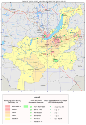
    <content:encoded xmlns:content="http://purl.org/rss/1.0/modules/content/"><![CDATA[<p><img class="image-inline" src="../../../resolveuid/af5951e96fc844c1ab80014138f880e3/@@images/image/preview" /></p>
<p><a href="http://bic.iwlearn.org/en/atlas/photos/copy_of__72_Ruralpopulationdensityandurbansettlementpopulationsize2013.png" class="internal-link">Open full size</a></p>
<p align="center"><strong>Population</strong></p>
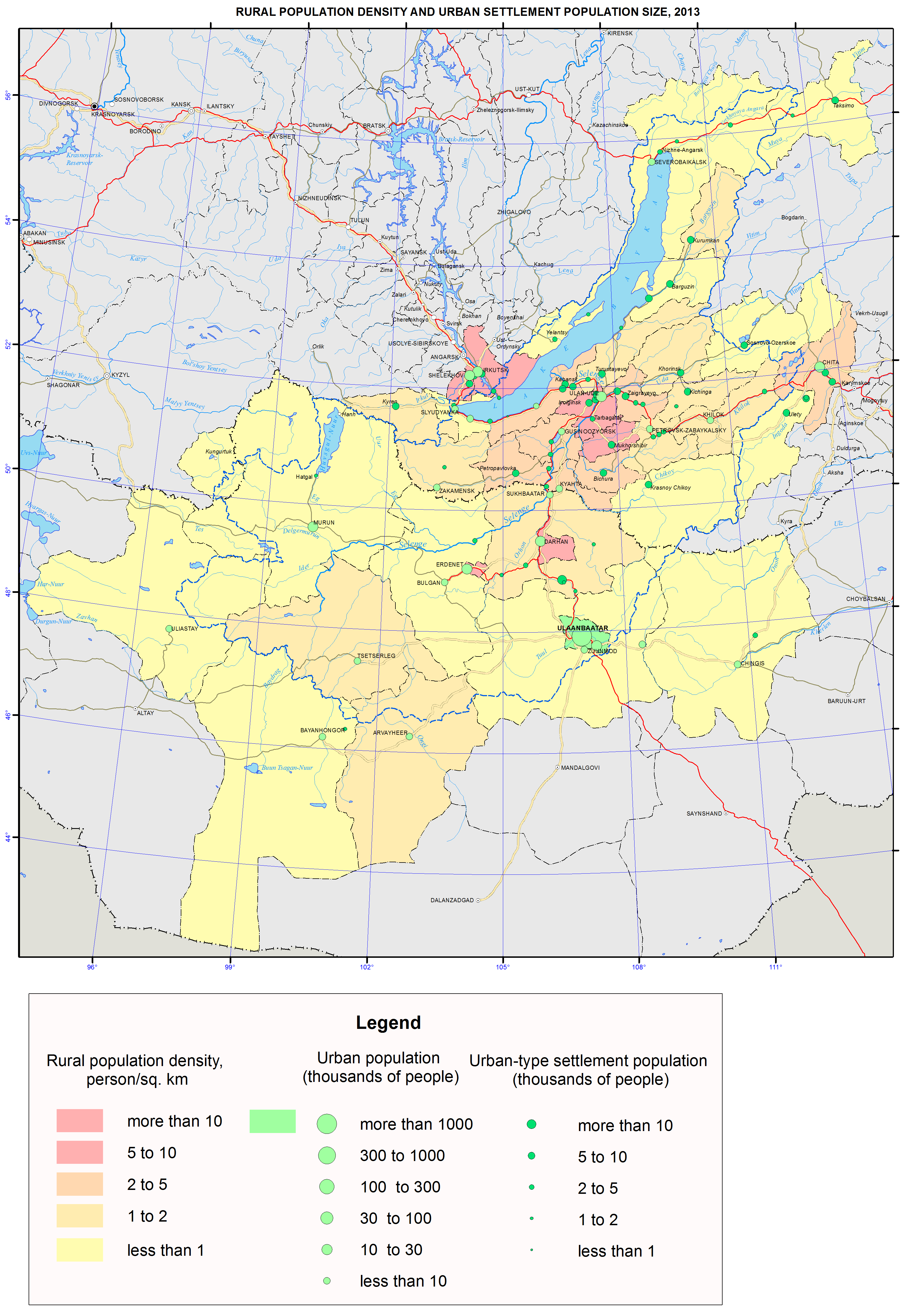
<p>The population maps focus on current patterns of the settlement and demographic situation in the Baikal basin. They relate to a complex of underlying social, economic and ecological factors.</p>
<p>The population maps of the Baikal basin are based on the statistical data of the Federal State Statistics Service of the Russian Federation and National Statistical Office of <em>Mongolia</em>. Also important were the data from population censuses of Russia and Mongolia and the data of the current measurements of demographic events. The authors used statistical sources to calculate indicators for territories included into the Baikal basin.</p>
<p>The distribution of settlements within the Baikal basin is quite irregular. There are four locations of the regional concentration of the population. In Irkutsk oblast, the main settlement belt along the Trans-Siberian Railway stretches from the western border of the region up to Lake Baikal. Here, there are many agricultural settlements and the majority of large administrative and economic centers, where manufacturing sector dominates the economy. Irkutsk – a large multi-functional center – tops the group of these settlements. Only sparsely populated the Olkhon and Slyudyanka districts and part of the Irkutsk district fully lie within the Baikal basin. In the direct vicinity of Lake Baikal, but in the Angara basin, there are cities of Irkutsk and Shelekhov. In the Republic of Buryatia, there is a major settlement area around Ulan-Ude with a maximum concentration to the south of the city. Geographic differences in the specialization of settlements have emerged. Settlements involved in manufacturing and transportation are overwhelmingly dominant along the Trans-Siberian Railway. In Southern Buryatia, there are mostly agricultural settlements. In Zabaikalsky krai, there are three settlement networks: settlements involved in manufacturing and transportation located along the railway; mining settlements near deposits; and agricultural settlements located south of Chita in the forest-steppe and steppe zone. In Mongolia, the population is mainly concentrated in the central region – from Ulaanbaatar in the south to Sukhbaatar in the north. Three largest cities of the country and more than a half of its population are located in this area. The other territories of the Mongolian part of the Baikal basin are sparsely populated.</p>
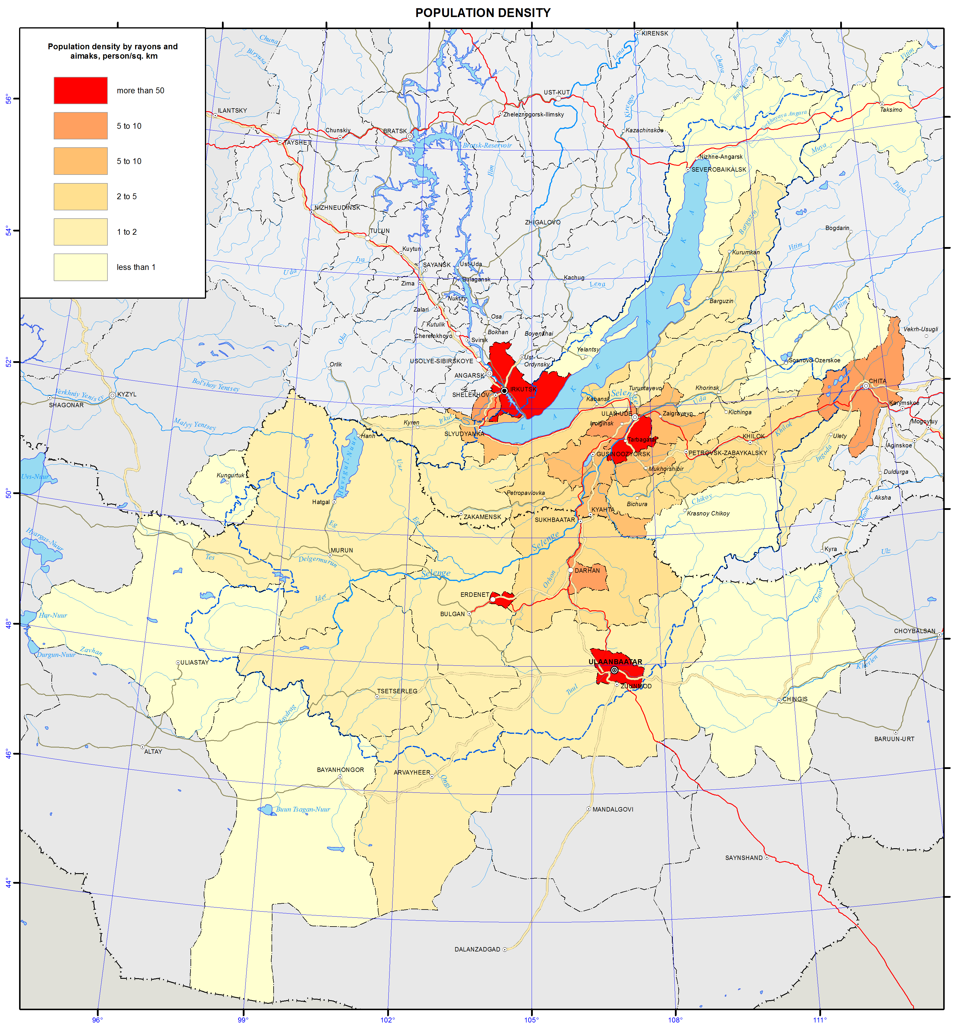
<p>Distribution of the population and the degree of the settlement of the territory are displayed on the maps “Density of population (as of 1.1.2013)”; “Density of rural population and population size of urban settlements (as of 1.1.1989)”; “Density of rural population and population size of urban settlements (as of 1.1.2013)”.</p>
<p>The Baikal region belongs to sparsely and unevenly populated territories. The population density of the Baikal basin is 17 times lower than the world’s average of 53 persons/km<sup>2</sup>. The population density in the Russian part of the basin is 2.9 persons/km<sup>2</sup>, which is nine times lower than in the European part of Russia (26 persons/km<sup>2</sup>).</p>
<p>The intra-regional differentiation of settlement patterns is stipulated by several spatial gradients of the population density decrease, with the main gradient leading from the center (capitals and administrative centers) to the periphery. Other gradients are also present in particular territories. Thus, in the Russian part of the basin, the population density tends to decrease as it goes from the south to the north and from the west to the east. The Russian-Mongolian border for the most part rather separates than unites the areas of settlement, except for one direction. The core of this direction is the Selenga Valley, where an area with a highly dense population has formed between Ulaanbaatar and Ulan-Ude.</p>
<p>The territories around large cities, like the regional centers Irkutsk, Ulan-Ude and Chita, are most densely populated. Along with the areas with dense population, there are also virtually unpopulated territories of tens of thousands square kilometers in area. The distribution of rural population is less contrasting than the urban one. The main clusters of rural population are located in the forest-steppe and steppe zones, where the density of population may reach 10-20 persons/km<sup>2</sup>. Rural population is mainly concentrated in the south of Irkutsk oblast (around Irkutsk) and in the central part of Buryatia (south of Ulan-Ude).</p>
<p>The major cities of the Russian part of the basin grew along the transportation lines. Thus, 11 out of 13 towns are located along the railways. Only Zakamensk and Kyakhta are located away from the railroad. In the Mongolian part of the basin, the connection of urban settlements to transportation lines is less pronounced with only five out of 12 towns being situated on the railways.</p>
<p>The map “Dynamics of the population size (1989-2013)” shows considerable changes in the population size – a situation, where a high concentration of the population in a few largest centers is followed by depopulation of vast territories.</p>
<p>In the Russian part of the basin, there were two clear patterns of the population size dynamics from 1989 to 2013. Firstly, the decrease of population tends to be more pronounced from the southwest to the northeast. Secondly, the population dynamics in regional centers (Irkutsk, Ulan-Ude, and Chita) and their suburbs is relatively positive. Population growth is observed only in the Irkutsk, Shelekhov, and Olkhon districts of Irkutsk oblast, Ivolga district of the Republic of Buryatia and Chita district of Zabaikalsky krai. The record level growth of population (over 160 %) was recorded in the suburban Ivolginsky and Irkutsk districts. The biggest drop in the population takes place in the localities that are classified as districts of the Far North, with the Muisky and Severobaikalsky districts of the Republic of Buryatia loosing over half of their population.</p>
<p>In the Mongolian part of the Baikal basin, population growth is registered on over a half of the nation’s territory. The main Mongolian cities – Ulaanbaatar, the capital of Mongolia, (244 % to the level of 1989), Erdenet, and Darkhan are the fastest growing cities. The Khovsgol and Selenga aimags also demonstrate a significant growth of population. The population in the four aimags of Arkhangai, Zavkhan, Tov, and Khentei decreases due to an outward migration of residents.</p>
<p>The contrasting nature of the population dynamics within the Baikal basin is quite distinct:</p>
<p>– The Russian part of the Baikal basin is characterized by the type of the population dynamics, where an outward migration is several times higher than a natural population decline;</p>
<p>–        The Mongolian part is characterized by the type of the population dynamics, where a natural increase of population prevails over inward migration.</p>
<p>Territorial specifics of demographic development are shown on the map “Natural increase of population”.</p>
<p>In the Baikal basin, different modes of reproduction of population exist along with a wide variety of quantitative parameters of demographic processes. In general, it is possible to identify two types of population reproduction. Thus, all of Mongolia, Tuva and part of Buryatia are characterized by an expanded type of reproduction with high birth rates, average mortality, and a significant natural growth. The Baikal region of Irkutsk oblast, Zabaikalsky krai, and most of Buryatia is characterized by a narrow type of reproduction with low birth rates, high mortality, and a natural population decline or insignificant natural growth. The annual natural growth of the population in Mongolian aimags is 17-19%. In the Russian part of the basin, natural movement of the population led to mixed results, where 23 municipalities showed population increase, while 10 municipalities had natural decline. With an average natural population increase of 1.4 per mille, there were significant variations – from the decline ranging from -5 to -6% (in the Petrovsk-Zabaikalsky, Irkutsk and Olkhon districts) to the increase exceeding 10 pro mille (10.4% in the Dzhida district, 12.1% in the Kizhinga District, and 16.0% in the Tere-Khol district). The natural population increase in the Mongolian capital Ulaanbaatar was 17.2%, while the increase in the Russian regional centers Ulan-Ude and Chita was 4.3% and 3.4%, respectively, with the decline of -2.7 % in Irkutsk.</p>
<p>The map “Urbanization of the territory” shows the proportion of urban population in Russian municipal districts and Mongolian aimags. The share of urban population exceeds 74% of the entire population and is composed of a few territories. The level of the urbanization of the population exceeds the world’s average (51%) by nearly one and half times, however, the level of the urbanization of the territory is low. Urban territories mainly include settlements located along the railways, as well as densely populated administrative centers. In the Mongolian part of the Baikal basin, only Ulaanbaatar and the Orkhon and Darkhan-uul aimags are highly urbanized, while the remaining nine aimags have only a small share of urban population (17.5%-34.9 %). In Mongolia, administrative centers of every aimag must be urban settlements. However, in Russia, the legislation does not mandate municipalities to have urban settlements. Therefore, in the Russian part of the basin, as of 2013, 14 districts did not have urban population at all. Some settlements (Barguzin, Ivolginsk, Kyren, and Khorinsk) rejected their urban status in the process of municipal reforms of the 2000s. The population of Mongolian towns within the basin nearly doubled in 1989-2013, with the population of Ulaanbaatar growing from 540.6 to 1,318.1 thousand people. The population of the largest cities in the Russian part of the basin did not change that much: in Irkutsk, it grew from 572.4 to 606.1 thousand people, in Ulan-Ude – from 352.5 to 416.1, while in Chita it declined from 365.8 to 331.3 thousand people.</p>
<p>The main results of migration processes in 2010-2012 are shown on the map “Migratory increase of population”.</p>
<p>In Russia, including the Baikal basin, the last two decades witnessed a significant decrease of migration activity of the population. However, outward migration from the region remains high and reproduces almost annually from the mid-1990s up to now. Population movement has mostly become intra-regional – the intra-regional migration turnover makes about 2/3 of relocations in the Baikal basin. The intra-Russian interregional migration causes migration losses, while migratory relationships with the CIS countries contribute to a considerable growth of population.</p>
<p>Redistribution of the population between the constituent parts of the Baikal region is intensive including some tens of thousands people annually. In 2010-2012, on average 66.5 thousand people arrived, and 58.6 thousand left. In the Baikal region, the average annual migration increment was 7.9 thousand people. However, it was due to the growth in the attractive for migrants cities of Irkutsk and the Irkutsk district (+9.3 thousand people), Ulan-Ude (+3.4 thousand people) and Chita (+2.9 thousand people). The total growth of the population in these cities was 15.6 thousand people. The rest of the region experienced the outflow of residents totaling 7.7 thousand people. Migration redistribution leads to the growth of the population in regional centers and their suburbs. Only 10 municipalities had a migratory growth, while the rest 24 showed a decline. The intensity of migrant arrivals is highest (twice as high as average) in the suburban Irkutsk and Ivolginsky districts, while the intensity of departures is highest (twice as high as average) in the undeveloped Dzhida, Kizhinga and Muisky districts. Against this backdrop, the Russian part of the Baikal basin has two migration poles – the Irkutsk and Dzhida districts, where an average annual migration balance is +47.4% and -46.0%, accordingly.</p>
<p>In general, the majority of territories is characterized by a progressive outward migration, which is compounded by unfavorable structural features of the outflow (with young and educated groups of people leaving the region). The results of migration movement are clearly expressed in terms of the center-periphery relationship: there are three areas of migration growth in the Russian part of the basin (Irkutsk, Ulan-Ude, and Chita with their suburban districts) and one in the Mongolian part, which combines the capital Ulaanbaatar and the aimags lying to the north of it –  Selenge, Orkhon, and Darkhan.</p>]]></content:encoded>
    <dc:publisher>No publisher</dc:publisher>
    <dc:creator>Alexander Ayurzhanaev</dc:creator>
    <dc:rights></dc:rights>
    <dc:date>2014-10-09T03:30:00Z</dc:date>
    <dc:type>Page</dc:type>
  </item>


  <item rdf:about="http://bic.iwlearn.org/en/atlas/atlas/71-rural-population-density-and-urban-settlement-population-size-1989-map/rural-population-density-and-urban-settlement-population-size-1989-map">
    <title>Rural population density and urban settlement population size, 1989 map</title>
    <link>http://bic.iwlearn.org/en/atlas/atlas/71-rural-population-density-and-urban-settlement-population-size-1989-map/rural-population-density-and-urban-settlement-population-size-1989-map</link>
    <description></description>
    <content:encoded xmlns:content="http://purl.org/rss/1.0/modules/content/"><![CDATA[<p><img class="image-inline" src="../../../resolveuid/9c41e5d3674a4407915d486b95bd652c/@@images/image/preview" /></p>
<p><a href="http://bic.iwlearn.org/en/atlas/photos/copy_of__71_Ruralpopulationdensityandurbansettlementpopulationsize1989.png" class="internal-link">Open full size</a></p>
<p align="center"><strong>Population </strong></p>
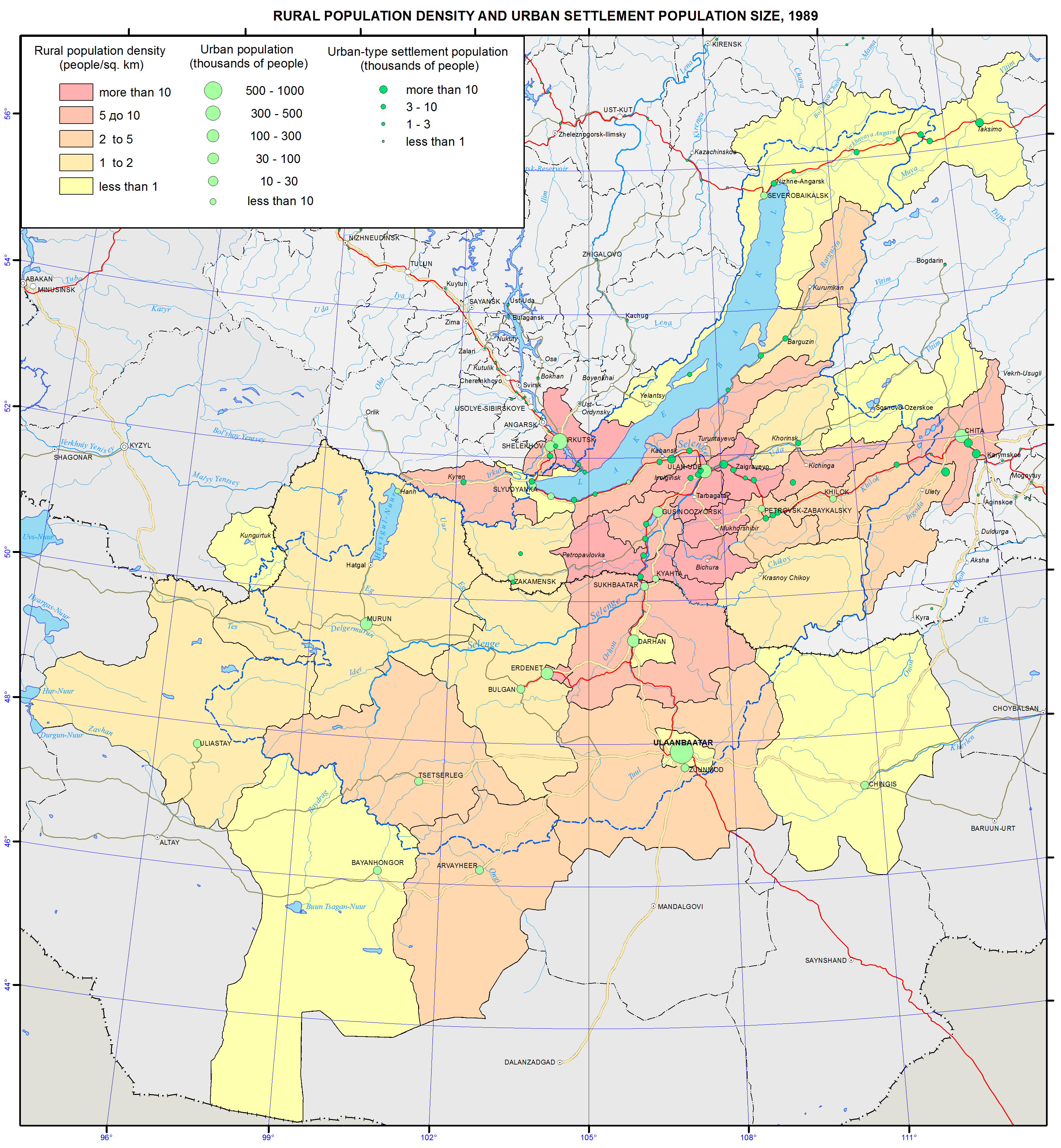
<p>The population maps focus on current patterns of the settlement and demographic situation in the Baikal basin. They relate to a complex of underlying social, economic and ecological factors.</p>
<p>The population maps of the Baikal basin are based on the statistical data of the Federal State Statistics Service of the Russian Federation and National Statistical Office of <em>Mongolia</em>. Also important were the data from population censuses of Russia and Mongolia and the data of the current measurements of demographic events. The authors used statistical sources to calculate indicators for territories included into the Baikal basin.</p>
<p>The distribution of settlements within the Baikal basin is quite irregular. There are four locations of the regional concentration of the population. In Irkutsk oblast, the main settlement belt along the Trans-Siberian Railway stretches from the western border of the region up to Lake Baikal. Here, there are many agricultural settlements and the majority of large administrative and economic centers, where manufacturing sector dominates the economy. Irkutsk – a large multi-functional center – tops the group of these settlements. Only sparsely populated the Olkhon and Slyudyanka districts and part of the Irkutsk district fully lie within the Baikal basin. In the direct vicinity of Lake Baikal, but in the Angara basin, there are cities of Irkutsk and Shelekhov. In the Republic of Buryatia, there is a major settlement area around Ulan-Ude with a maximum concentration to the south of the city. Geographic differences in the specialization of settlements have emerged. Settlements involved in manufacturing and transportation are overwhelmingly dominant along the Trans-Siberian Railway. In Southern Buryatia, there are mostly agricultural settlements. In Zabaikalsky krai, there are three settlement networks: settlements involved in manufacturing and transportation located along the railway; mining settlements near deposits; and agricultural settlements located south of Chita in the forest-steppe and steppe zone. In Mongolia, the population is mainly concentrated in the central region – from Ulaanbaatar in the south to Sukhbaatar in the north. Three largest cities of the country and more than a half of its population are located in this area. The other territories of the Mongolian part of the Baikal basin are sparsely populated.</p>
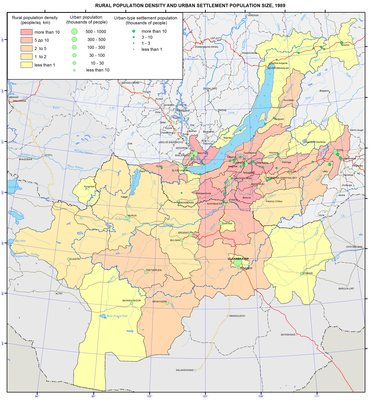
<p>Distribution of the population and the degree of the settlement of the territory are displayed on the maps “Density of population (as of 1.1.2013)”; “Density of rural population and population size of urban settlements (as of 1.1.1989)”; “Density of rural population and population size of urban settlements (as of 1.1.2013)”.</p>
<p>The Baikal region belongs to sparsely and unevenly populated territories. The population density of the Baikal basin is 17 times lower than the world’s average of 53 persons/km<sup>2</sup>. The population density in the Russian part of the basin is 2.9 persons/km<sup>2</sup>, which is nine times lower than in the European part of Russia (26 persons/km<sup>2</sup>).</p>
<p>The intra-regional differentiation of settlement patterns is stipulated by several spatial gradients of the population density decrease, with the main gradient leading from the center (capitals and administrative centers) to the periphery. Other gradients are also present in particular territories. Thus, in the Russian part of the basin, the population density tends to decrease as it goes from the south to the north and from the west to the east. The Russian-Mongolian border for the most part rather separates than unites the areas of settlement, except for one direction. The core of this direction is the Selenga Valley, where an area with a highly dense population has formed between Ulaanbaatar and Ulan-Ude.</p>
<p>The territories around large cities, like the regional centers Irkutsk, Ulan-Ude and Chita, are most densely populated. Along with the areas with dense population, there are also virtually unpopulated territories of tens of thousands square kilometers in area. The distribution of rural population is less contrasting than the urban one. The main clusters of rural population are located in the forest-steppe and steppe zones, where the density of population may reach 10-20 persons/km<sup>2</sup>. Rural population is mainly concentrated in the south of Irkutsk oblast (around Irkutsk) and in the central part of Buryatia (south of Ulan-Ude).</p>
<p>The major cities of the Russian part of the basin grew along the transportation lines. Thus, 11 out of 13 towns are located along the railways. Only Zakamensk and Kyakhta are located away from the railroad. In the Mongolian part of the basin, the connection of urban settlements to transportation lines is less pronounced with only five out of 12 towns being situated on the railways.</p>
<p>The map “Dynamics of the population size (1989-2013)” shows considerable changes in the population size – a situation, where a high concentration of the population in a few largest centers is followed by depopulation of vast territories.</p>
<p>In the Russian part of the basin, there were two clear patterns of the population size dynamics from 1989 to 2013. Firstly, the decrease of population tends to be more pronounced from the southwest to the northeast. Secondly, the population dynamics in regional centers (Irkutsk, Ulan-Ude, and Chita) and their suburbs is relatively positive. Population growth is observed only in the Irkutsk, Shelekhov, and Olkhon districts of Irkutsk oblast, Ivolga district of the Republic of Buryatia and Chita district of Zabaikalsky krai. The record level growth of population (over 160 %) was recorded in the suburban Ivolginsky and Irkutsk districts. The biggest drop in the population takes place in the localities that are classified as districts of the Far North, with the Muisky and Severobaikalsky districts of the Republic of Buryatia loosing over half of their population.</p>
<p>In the Mongolian part of the Baikal basin, population growth is registered on over a half of the nation’s territory. The main Mongolian cities – Ulaanbaatar, the capital of Mongolia, (244 % to the level of 1989), Erdenet, and Darkhan are the fastest growing cities. The Khovsgol and Selenga aimags also demonstrate a significant growth of population. The population in the four aimags of Arkhangai, Zavkhan, Tov, and Khentei decreases due to an outward migration of residents.</p>
<p>The contrasting nature of the population dynamics within the Baikal basin is quite distinct:</p>
<p>– The Russian part of the Baikal basin is characterized by the type of the population dynamics, where an outward migration is several times higher than a natural population decline;</p>
<p>–        The Mongolian part is characterized by the type of the population dynamics, where a natural increase of population prevails over inward migration.</p>
<p>Territorial specifics of demographic development are shown on the map “Natural increase of population”.</p>
<p>In the Baikal basin, different modes of reproduction of population exist along with a wide variety of quantitative parameters of demographic processes. In general, it is possible to identify two types of population reproduction. Thus, all of Mongolia, Tuva and part of Buryatia are characterized by an expanded type of reproduction with high birth rates, average mortality, and a significant natural growth. The Baikal region of Irkutsk oblast, Zabaikalsky krai, and most of Buryatia is characterized by a narrow type of reproduction with low birth rates, high mortality, and a natural population decline or insignificant natural growth. The annual natural growth of the population in Mongolian aimags is 17-19%. In the Russian part of the basin, natural movement of the population led to mixed results, where 23 municipalities showed population increase, while 10 municipalities had natural decline. With an average natural population increase of 1.4 per mille, there were significant variations – from the decline ranging from -5 to -6% (in the Petrovsk-Zabaikalsky, Irkutsk and Olkhon districts) to the increase exceeding 10 pro mille (10.4% in the Dzhida district, 12.1% in the Kizhinga District, and 16.0% in the Tere-Khol district). The natural population increase in the Mongolian capital Ulaanbaatar was 17.2%, while the increase in the Russian regional centers Ulan-Ude and Chita was 4.3% and 3.4%, respectively, with the decline of -2.7 % in Irkutsk.</p>
<p>The map “Urbanization of the territory” shows the proportion of urban population in Russian municipal districts and Mongolian aimags. The share of urban population exceeds 74% of the entire population and is composed of a few territories. The level of the urbanization of the population exceeds the world’s average (51%) by nearly one and half times, however, the level of the urbanization of the territory is low. Urban territories mainly include settlements located along the railways, as well as densely populated administrative centers. In the Mongolian part of the Baikal basin, only Ulaanbaatar and the Orkhon and Darkhan-uul aimags are highly urbanized, while the remaining nine aimags have only a small share of urban population (17.5%-34.9 %). In Mongolia, administrative centers of every aimag must be urban settlements. However, in Russia, the legislation does not mandate municipalities to have urban settlements. Therefore, in the Russian part of the basin, as of 2013, 14 districts did not have urban population at all. Some settlements (Barguzin, Ivolginsk, Kyren, and Khorinsk) rejected their urban status in the process of municipal reforms of the 2000s. The population of Mongolian towns within the basin nearly doubled in 1989-2013, with the population of Ulaanbaatar growing from 540.6 to 1,318.1 thousand people. The population of the largest cities in the Russian part of the basin did not change that much: in Irkutsk, it grew from 572.4 to 606.1 thousand people, in Ulan-Ude – from 352.5 to 416.1, while in Chita it declined from 365.8 to 331.3 thousand people.</p>
<p>The main results of migration processes in 2010-2012 are shown on the map “Migratory increase of population”.</p>
<p>In Russia, including the Baikal basin, the last two decades witnessed a significant decrease of migration activity of the population. However, outward migration from the region remains high and reproduces almost annually from the mid-1990s up to now. Population movement has mostly become intra-regional – the intra-regional migration turnover makes about 2/3 of relocations in the Baikal basin. The intra-Russian interregional migration causes migration losses, while migratory relationships with the CIS countries contribute to a considerable growth of population.</p>
<p>Redistribution of the population between the constituent parts of the Baikal region is intensive including some tens of thousands people annually. In 2010-2012, on average 66.5 thousand people arrived, and 58.6 thousand left. In the Baikal region, the average annual migration increment was 7.9 thousand people. However, it was due to the growth in the attractive for migrants cities of Irkutsk and the Irkutsk district (+9.3 thousand people), Ulan-Ude (+3.4 thousand people) and Chita (+2.9 thousand people). The total growth of the population in these cities was 15.6 thousand people. The rest of the region experienced the outflow of residents totaling 7.7 thousand people. Migration redistribution leads to the growth of the population in regional centers and their suburbs. Only 10 municipalities had a migratory growth, while the rest 24 showed a decline. The intensity of migrant arrivals is highest (twice as high as average) in the suburban Irkutsk and Ivolginsky districts, while the intensity of departures is highest (twice as high as average) in the undeveloped Dzhida, Kizhinga and Muisky districts. Against this backdrop, the Russian part of the Baikal basin has two migration poles – the Irkutsk and Dzhida districts, where an average annual migration balance is +47.4% and -46.0%, accordingly.</p>
<p>In general, the majority of territories is characterized by a progressive outward migration, which is compounded by unfavorable structural features of the outflow (with young and educated groups of people leaving the region). The results of migration movement are clearly expressed in terms of the center-periphery relationship: there are three areas of migration growth in the Russian part of the basin (Irkutsk, Ulan-Ude, and Chita with their suburban districts) and one in the Mongolian part, which combines the capital Ulaanbaatar and the aimags lying to the north of it –  Selenge, Orkhon, and Darkhan.</p>]]></content:encoded>
    <dc:publisher>No publisher</dc:publisher>
    <dc:creator>Alexander Ayurzhanaev</dc:creator>
    <dc:rights></dc:rights>
    <dc:date>2014-10-09T03:20:00Z</dc:date>
    <dc:type>Page</dc:type>
  </item>


  <item rdf:about="http://bic.iwlearn.org/en/atlas/atlas/70-population-density-map/population-density-map">
    <title>Population density map</title>
    <link>http://bic.iwlearn.org/en/atlas/atlas/70-population-density-map/population-density-map</link>
    <description></description>
    <content:encoded xmlns:content="http://purl.org/rss/1.0/modules/content/"><![CDATA[<p><img class="image-inline" src="../../../resolveuid/347b111b595441049af9451b96ad1e64/@@images/image/preview" /></p>
<p><a href="http://bic.iwlearn.org/en/atlas/photos/copy_of__70_PopulationDensity.png" class="internal-link">Open full size</a></p>
<p align="center"><strong>Population</strong></p>
<p>The population maps focus on current patterns of the settlement and demographic situation in the Baikal basin. They relate to a complex of underlying social, economic and ecological factors.</p>
<p>The population maps of the Baikal basin are based on the statistical data of the Federal State Statistics Service of the Russian Federation and National Statistical Office of <em>Mongolia</em>. Also important were the data from population censuses of Russia and Mongolia and the data of the current measurements of demographic events. The authors used statistical sources to calculate indicators for territories included into the Baikal basin.</p>
<p>The distribution of settlements within the Baikal basin is quite irregular. There are four locations of the regional concentration of the population. In Irkutsk oblast, the main settlement belt along the Trans-Siberian Railway stretches from the western border of the region up to Lake Baikal. Here, there are many agricultural settlements and the majority of large administrative and economic centers, where manufacturing sector dominates the economy. Irkutsk – a large multi-functional center – tops the group of these settlements. Only sparsely populated the Olkhon and Slyudyanka districts and part of the Irkutsk district fully lie within the Baikal basin. In the direct vicinity of Lake Baikal, but in the Angara basin, there are cities of Irkutsk and Shelekhov. In the Republic of Buryatia, there is a major settlement area around Ulan-Ude with a maximum concentration to the south of the city. Geographic differences in the specialization of settlements have emerged. Settlements involved in manufacturing and transportation are overwhelmingly dominant along the Trans-Siberian Railway. In Southern Buryatia, there are mostly agricultural settlements. In Zabaikalsky krai, there are three settlement networks: settlements involved in manufacturing and transportation located along the railway; mining settlements near deposits; and agricultural settlements located south of Chita in the forest-steppe and steppe zone. In Mongolia, the population is mainly concentrated in the central region – from Ulaanbaatar in the south to Sukhbaatar in the north. Three largest cities of the country and more than a half of its population are located in this area. The other territories of the Mongolian part of the Baikal basin are sparsely populated.</p>
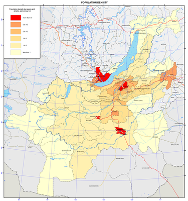
<p>Distribution of the population and the degree of the settlement of the territory are displayed on the maps “Density of population (as of 1.1.2013)”; “Density of rural population and population size of urban settlements (as of 1.1.1989)”; “Density of rural population and population size of urban settlements (as of 1.1.2013)”.</p>
<p>The Baikal region belongs to sparsely and unevenly populated territories. The population density of the Baikal basin is 17 times lower than the world’s average of 53 persons/km<sup>2</sup>. The population density in the Russian part of the basin is 2.9 persons/km<sup>2</sup>, which is nine times lower than in the European part of Russia (26 persons/km<sup>2</sup>).</p>
<p>The intra-regional differentiation of settlement patterns is stipulated by several spatial gradients of the population density decrease, with the main gradient leading from the center (capitals and administrative centers) to the periphery. Other gradients are also present in particular territories. Thus, in the Russian part of the basin, the population density tends to decrease as it goes from the south to the north and from the west to the east. The Russian-Mongolian border for the most part rather separates than unites the areas of settlement, except for one direction. The core of this direction is the Selenga Valley, where an area with a highly dense population has formed between Ulaanbaatar and Ulan-Ude.</p>
<p>The territories around large cities, like the regional centers Irkutsk, Ulan-Ude and Chita, are most densely populated. Along with the areas with dense population, there are also virtually unpopulated territories of tens of thousands square kilometers in area. The distribution of rural population is less contrasting than the urban one. The main clusters of rural population are located in the forest-steppe and steppe zones, where the density of population may reach 10-20 persons/km<sup>2</sup>. Rural population is mainly concentrated in the south of Irkutsk oblast (around Irkutsk) and in the central part of Buryatia (south of Ulan-Ude).</p>
<p>The major cities of the Russian part of the basin grew along the transportation lines. Thus, 11 out of 13 towns are located along the railways. Only Zakamensk and Kyakhta are located away from the railroad. In the Mongolian part of the basin, the connection of urban settlements to transportation lines is less pronounced with only five out of 12 towns being situated on the railways.</p>
<p>The map “Dynamics of the population size (1989-2013)” shows considerable changes in the population size – a situation, where a high concentration of the population in a few largest centers is followed by depopulation of vast territories.</p>
<p>In the Russian part of the basin, there were two clear patterns of the population size dynamics from 1989 to 2013. Firstly, the decrease of population tends to be more pronounced from the southwest to the northeast. Secondly, the population dynamics in regional centers (Irkutsk, Ulan-Ude, and Chita) and their suburbs is relatively positive. Population growth is observed only in the Irkutsk, Shelekhov, and Olkhon districts of Irkutsk oblast, Ivolga district of the Republic of Buryatia and Chita district of Zabaikalsky krai. The record level growth of population (over 160 %) was recorded in the suburban Ivolginsky and Irkutsk districts. The biggest drop in the population takes place in the localities that are classified as districts of the Far North, with the Muisky and Severobaikalsky districts of the Republic of Buryatia loosing over half of their population.</p>
<p>In the Mongolian part of the Baikal basin, population growth is registered on over a half of the nation’s territory. The main Mongolian cities – Ulaanbaatar, the capital of Mongolia, (244 % to the level of 1989), Erdenet, and Darkhan are the fastest growing cities. The Khovsgol and Selenga aimags also demonstrate a significant growth of population. The population in the four aimags of Arkhangai, Zavkhan, Tov, and Khentei decreases due to an outward migration of residents.</p>
<p>The contrasting nature of the population dynamics within the Baikal basin is quite distinct:</p>
<p>– The Russian part of the Baikal basin is characterized by the type of the population dynamics, where an outward migration is several times higher than a natural population decline;</p>
<p>–        The Mongolian part is characterized by the type of the population dynamics, where a natural increase of population prevails over inward migration.</p>
<p>Territorial specifics of demographic development are shown on the map “Natural increase of population”.</p>
<p>In the Baikal basin, different modes of reproduction of population exist along with a wide variety of quantitative parameters of demographic processes. In general, it is possible to identify two types of population reproduction. Thus, all of Mongolia, Tuva and part of Buryatia are characterized by an expanded type of reproduction with high birth rates, average mortality, and a significant natural growth. The Baikal region of Irkutsk oblast, Zabaikalsky krai, and most of Buryatia is characterized by a narrow type of reproduction with low birth rates, high mortality, and a natural population decline or insignificant natural growth. The annual natural growth of the population in Mongolian aimags is 17-19%. In the Russian part of the basin, natural movement of the population led to mixed results, where 23 municipalities showed population increase, while 10 municipalities had natural decline. With an average natural population increase of 1.4 per mille, there were significant variations – from the decline ranging from -5 to -6% (in the Petrovsk-Zabaikalsky, Irkutsk and Olkhon districts) to the increase exceeding 10 pro mille (10.4% in the Dzhida district, 12.1% in the Kizhinga District, and 16.0% in the Tere-Khol district). The natural population increase in the Mongolian capital Ulaanbaatar was 17.2%, while the increase in the Russian regional centers Ulan-Ude and Chita was 4.3% and 3.4%, respectively, with the decline of -2.7 % in Irkutsk.</p>
<p>The map “Urbanization of the territory” shows the proportion of urban population in Russian municipal districts and Mongolian aimags. The share of urban population exceeds 74% of the entire population and is composed of a few territories. The level of the urbanization of the population exceeds the world’s average (51%) by nearly one and half times, however, the level of the urbanization of the territory is low. Urban territories mainly include settlements located along the railways, as well as densely populated administrative centers. In the Mongolian part of the Baikal basin, only Ulaanbaatar and the Orkhon and Darkhan-uul aimags are highly urbanized, while the remaining nine aimags have only a small share of urban population (17.5%-34.9 %). In Mongolia, administrative centers of every aimag must be urban settlements. However, in Russia, the legislation does not mandate municipalities to have urban settlements. Therefore, in the Russian part of the basin, as of 2013, 14 districts did not have urban population at all. Some settlements (Barguzin, Ivolginsk, Kyren, and Khorinsk) rejected their urban status in the process of municipal reforms of the 2000s. The population of Mongolian towns within the basin nearly doubled in 1989-2013, with the population of Ulaanbaatar growing from 540.6 to 1,318.1 thousand people. The population of the largest cities in the Russian part of the basin did not change that much: in Irkutsk, it grew from 572.4 to 606.1 thousand people, in Ulan-Ude – from 352.5 to 416.1, while in Chita it declined from 365.8 to 331.3 thousand people.</p>
<p>The main results of migration processes in 2010-2012 are shown on the map “Migratory increase of population”.</p>
<p>In Russia, including the Baikal basin, the last two decades witnessed a significant decrease of migration activity of the population. However, outward migration from the region remains high and reproduces almost annually from the mid-1990s up to now. Population movement has mostly become intra-regional – the intra-regional migration turnover makes about 2/3 of relocations in the Baikal basin. The intra-Russian interregional migration causes migration losses, while migratory relationships with the CIS countries contribute to a considerable growth of population.</p>
<p>Redistribution of the population between the constituent parts of the Baikal region is intensive including some tens of thousands people annually. In 2010-2012, on average 66.5 thousand people arrived, and 58.6 thousand left. In the Baikal region, the average annual migration increment was 7.9 thousand people. However, it was due to the growth in the attractive for migrants cities of Irkutsk and the Irkutsk district (+9.3 thousand people), Ulan-Ude (+3.4 thousand people) and Chita (+2.9 thousand people). The total growth of the population in these cities was 15.6 thousand people. The rest of the region experienced the outflow of residents totaling 7.7 thousand people. Migration redistribution leads to the growth of the population in regional centers and their suburbs. Only 10 municipalities had a migratory growth, while the rest 24 showed a decline. The intensity of migrant arrivals is highest (twice as high as average) in the suburban Irkutsk and Ivolginsky districts, while the intensity of departures is highest (twice as high as average) in the undeveloped Dzhida, Kizhinga and Muisky districts. Against this backdrop, the Russian part of the Baikal basin has two migration poles – the Irkutsk and Dzhida districts, where an average annual migration balance is +47.4% and -46.0%, accordingly.</p>
<p>In general, the majority of territories is characterized by a progressive outward migration, which is compounded by unfavorable structural features of the outflow (with young and educated groups of people leaving the region). The results of migration movement are clearly expressed in terms of the center-periphery relationship: there are three areas of migration growth in the Russian part of the basin (Irkutsk, Ulan-Ude, and Chita with their suburban districts) and one in the Mongolian part, which combines the capital Ulaanbaatar and the aimags lying to the north of it –  Selenge, Orkhon, and Darkhan.</p>]]></content:encoded>
    <dc:publisher>No publisher</dc:publisher>
    <dc:creator>Alexander Ayurzhanaev</dc:creator>
    <dc:rights></dc:rights>
    <dc:date>2014-10-09T03:05:00Z</dc:date>
    <dc:type>Page</dc:type>
  </item>


  <item rdf:about="http://bic.iwlearn.org/en/atlas/atlas/69-functional-ecological-settlement-types-map/functional-ecological-settlement-types-map">
    <title>Functional-ecological settlement types map</title>
    <link>http://bic.iwlearn.org/en/atlas/atlas/69-functional-ecological-settlement-types-map/functional-ecological-settlement-types-map</link>
    <description></description>
    <content:encoded xmlns:content="http://purl.org/rss/1.0/modules/content/"><![CDATA[<p><img class="image-inline" src="../../../resolveuid/18d5c9f6d09d45c18cc1477ed455e4fe/@@images/image/preview" /></p>
<p><a href="http://bic.iwlearn.org/en/atlas/photos/copy_of__69_Functionalecologicalsettlementtypes.png" class="internal-link">Open full size</a></p>
<p align="center"><strong>Functional types of settlements</strong></p>
<p align="center"><strong> </strong></p>
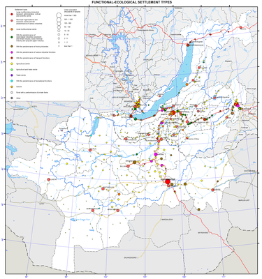
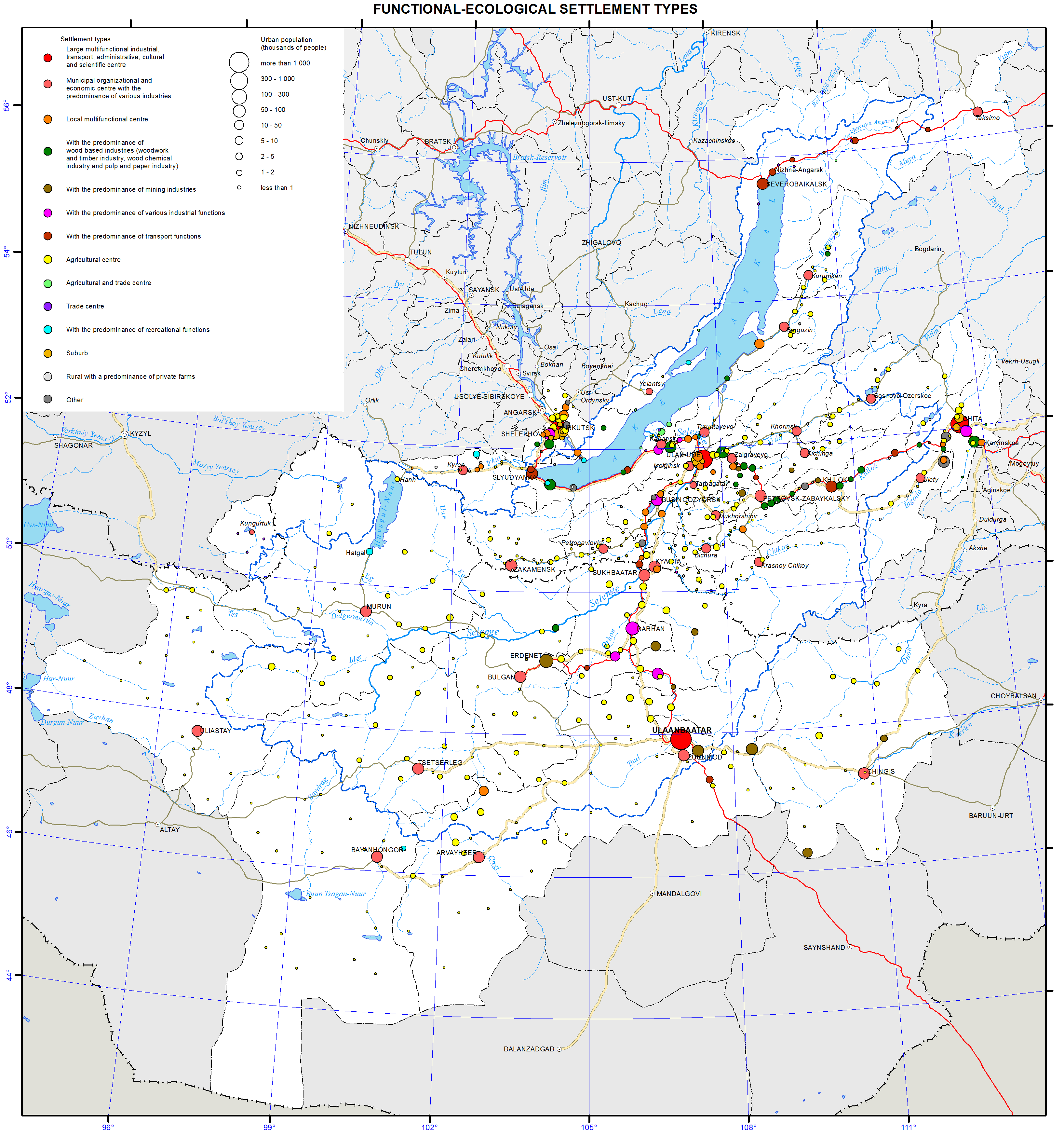
<p class="1">The map “Functional types of settlements” is created using conventional symbols. It shows the distribution of settlements within the Baikal basin and their economic significance. The main content of the map is the network of urban and rural settlements with their population. The size of population is shown by the symbols of different sizes in accordance with the selected scale of nine gradations of the population size. The color of symbols shows the functional type of settlements determined based on the structure of employment of the local population in various sectors of economy.</p>
<p class="1">A dominant role in the settlement network formed in the Baikal basin is played by large multi-functional industrial-transport, administrative-cultural, and scientific centers of the state (Ulaanbaatar) and regional (Irkutsk, Ulan-Ude, and Chita) significance.</p>
<p class="1">Various specialized industrial and transport centers are almost exclusively confined to the railway lines. Local organizational-economic centers performing the nodal functions of serving their hinterlands are scattered over a greater part of the territory. The dispersed pattern of settlement is especially clear in the Mongolian part of the Baikal basin, where each aimag is dominated by a corresponding administrative center with a sparse network of agricultural settlements.</p>
<p class="1">Quantitatively, the region’s territory is dominated by small rural settlements with agricultural functions; their predominance is especially high in Mongolia. They are scattered within the steppe areas and in the southern part of Buryatia, where they are confined to river valleys.</p>
<p class="1">Settlements with the predominance of recreational functions are few in number and are mainly confined to the shore of Lake Baikal (Listvyanka, Utulik, Khuzhir), to the shore of Khovsgol (Khatgal), and to the Tunkinskaya Valley (Arshan).</p>
<p class="1">Large-scale inset maps “Irkutsk”, “Ulan-Ude”, and “Chita” demonstrate functional types of settlement in the areas of direct influence of the respective regional centers, around which the specifics of the suburban type of settlement is clearly manifested.</p>
<p class="1"> </p>
<p class="1">The assessment of the demographic potential in the Baikal basin allows to identify the following key predetermining factors:</p>
<p class="1">— Ultra-continental geographic location in harsh environmental conditions and at a very large distance from densely populated areas of Eurasia;</p>
<p class="1">— Low investment activity, which slows down economic development and hampers structural shifts towards the innovation sector of the region;</p>
<p class="1">— Low demand for the region’s workforce potential from the existing economy, which is indicated by low wages and continuous outbound migration from the Russian part of the Baikal basin;</p>
<p class="1">— Territorial contrasts in the settlement patterns, social and demographic structures, employment, and living standards of the population between different localities, which is especially pronounced when comparing the Mongolian and Russian parts of the lake’s basin.</p>
<p class="1"> </p>
<p class="1"> </p>
<p align="center" class="1">References:</p>
<p class="1">Federal State Statistics Service. <i>Database of municipal indicators</i>. Retrieved from http://www.gks.ru/dbscripts/munst/munst.htm</p>
<p class="1">Federal State Statistics Service. Retrieved from http://www.gks.ru/</p>
<p class="1">Federal State Statistics Service. (2012). <i>Population of the Russian Federation in municipalities as of January 1, 2012</i>. Moscow: Rosstat. p 527.</p>
<p class="1">Federal State Statistics Service. (2013). <i>Population of the Russian Federation in municipalities as of January 1, 2013</i>. Moscow: Rosstat. p 525.</p>
<p class="1">All-Russia Population Census of 1989. (1991). <i>Population and settlement patterns, groupings of districts and rural councils by population, groupings of urban and rural settlements by types and population</i>. <i>Vol. 1</i>. Moscow.</p>
<p class="1">Federal State Statistics Service. (2011). <i>Results of All-Russian Population Census of 2010. Vol. 1. Population and settlement pattern</i>. Retrieved from http://www.gks.ru/free_doc/new_site/perepis2010/croc/perepis_itogi1612.htm</p>
<p class="1">National Statistical Office of Mongolia. (2011). <i>Mongolian Statistical Yearbook 2010</i>. Ulaanbaatar. p 463.</p>
<p>National Statistical Office of Mongolia. Retrieved from http://www.nso.mn/</p>]]></content:encoded>
    <dc:publisher>No publisher</dc:publisher>
    <dc:creator>Alexander Ayurzhanaev</dc:creator>
    <dc:rights></dc:rights>
    <dc:date>2014-10-09T03:00:00Z</dc:date>
    <dc:type>Page</dc:type>
  </item>


  <item rdf:about="http://bic.iwlearn.org/en/atlas/atlas/68-transport-infrastructure-map/transport-infrastructure">
    <title>Transport infrastructure map</title>
    <link>http://bic.iwlearn.org/en/atlas/atlas/68-transport-infrastructure-map/transport-infrastructure</link>
    <description></description>
    <content:encoded xmlns:content="http://purl.org/rss/1.0/modules/content/"><![CDATA[<p><img class="image-inline" src="../../../resolveuid/7e13088354044c09957e8a77de60b76d/@@images/image/preview" /></p>
<p><a href="http://bic.iwlearn.org/en/atlas/photos/copy_of__68_Transportinfrastructure.png" class="internal-link">Open full size</a></p>
<p align="center"><strong>Transport</strong></p>
<p align="center"><strong> </strong></p>
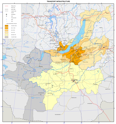
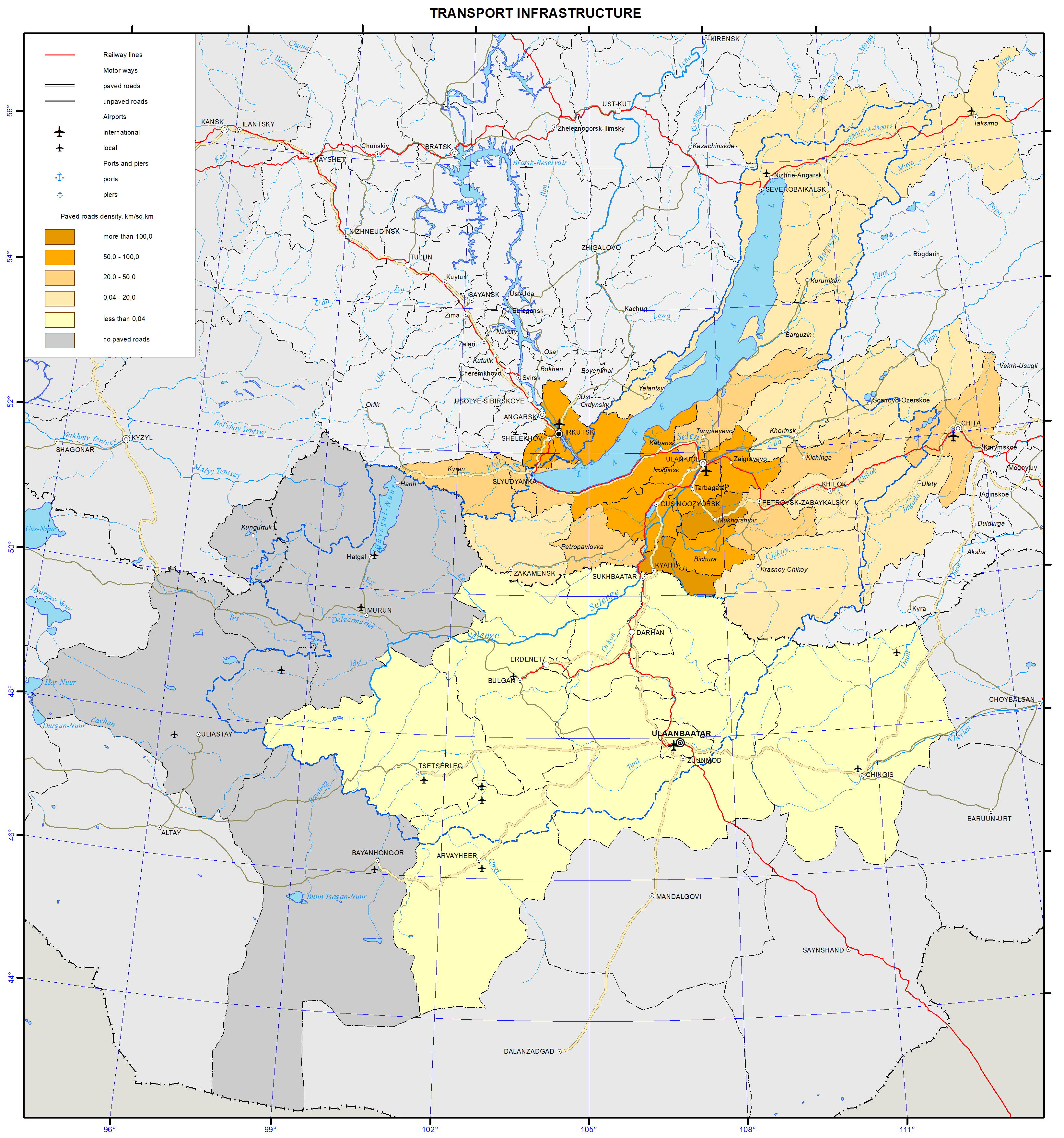
<p>Transportation infrastructure of the Baikal basin is a constituent part of the transportation systems of Irkutsk oblast, Republic of Buryatia, Zabaikalsky krai, and Mongolia. This territory has almost all modes of transportation, namely, railways, roads, shipping, and air transportation. The cities of Irkutsk and Chita located outside the Baikal basin are also considered, as they are important logistics hubs of the Baikal basin. <strong> </strong></p>
<p>Railways in the Russian part of the basin are part of the East Siberian Railway. Railway serves the Southern and Northern Baikal region. The Baikal-Amur Mainline runs along the northern shore of Lake Baikal and along the valley of the Upper Angara river. A short segment of the Trans-Siberian Railway runs along the southern shore of Lake Baikal and further to the east. In the Baikal basin, it forks into two railways – the Circum-Baikal Railway (84 km) and the Ulan-Ude – Naushki Railway (253 km), which runs all the way to Mongolia, where it connects to the Ulaanbaatar Railway. In Mongolia, the major railway is the one running from the Russian border through Ulaanbaatar to the border with China and further to Beijing. In the Baikal basin, this railway has branches to Erdenet, Sharyn Gol, and Baganuur.</p>
<p class="a">The effect of the railway transportation on the environment includes the impact on the atmosphere in the districts, where diesel locomotives are used. Transportation of explosives, chemicals, and other hazardous cargo is also potentially dangerous.</p>
<p class="a">The most important motorway is the federal highway Irkutsk – Ulan-Ude – Chita (a segment of the Moscow Highway), which runs parallel to the Trans-Siberian Railway. Besides this highway, the segments of the motorways Kultuk – Mondy, Irkutsk – Listvyanka, Magistralny – Severobaikalsk – Uoyan – Taksimo, Taksimo – Bodaibo, Bayanday – Elantsy – Khuzhir, Ulan-Ude – Turuntaevo – Kurumkan, Ulan-Ude – Kyakhta with a branch to Zakamensk, Ulan-Ude – Bichura, Ulan-Ude – Sosnovo-Ozerskoe – Bagdarin, Chita – Bagdarin, Chita – Aginskoe, etc. also run across this territory. In Mongolia, a hard surface highway runs from the Russian border to Ulaanbaatar and further to the border with China. There is a branch of this highway connecting Darkhan, Erdenet, and Bulgan. There are two more paved motorways running from Ulaanbaatar to Tsetserleg and Underhaan. The rest of Mongolian motorways are dirt roads. The main motorways shown on the map are federal highways in Russia and major inter-aimag roads in Mongolia.</p>
<p class="a">Motor vehicles are the most intensive source of environmental pollution. On average, one vehicle consumes about four tons of oxygen from the atmosphere annually and emits about 800 kg of carbon oxide, 40 kg of nitrogen oxide, and almost 200 kg of different carbons [1]. This pollution is more pronounced in settlements. Thus, in Ulan-Ude it makes 58% of the total pollutant emission, in Chita – 72%. The increased pollution in larger cities is associated with a more intensive use of auto transportation and high rates of car ownership among the general population. Moreover, noise from motor vehicles also negatively impacts people’s health in the cities. The impact of motor vehicles on the environment outside of settlements occurs along highways. The concentration of heavy metals along the highways increases 10 to 20 times as compared to the background level. Another factor of the impact of motor vehicles is the dust formation in the air near the ground especially on dirt and gravel roads. Off-road driving in Mongolian steppes and on the shores of Lake Baikal is also a problem, as it damages vegetation of local landscapes.</p>
<p class="a">Motor vehicle pollution in the Baikal basin is the major type of the impact of transportation on the environment and, especially, on human health.</p>
<p>Ship traffic in this territory takes place on Lake Baikal and Lake Khovsgol, as well as on the Angara and Selenga rivers. The fleet used on Lake Baikal in 2012 and registered by the East-Siberian Branch of the Russian River Register includes: 1) general service and recreational boats and search and rescue vessels; 2) dry cargo, passenger, expedition, and research vessels; 3) freight and passenger-and-freight ferries; 4) self-propelled tugboats; 5) dynamically supported ships; 6) buoy tenders [2].</p>
<p>Passenger service runs from Irkutsk to Olkhon Island, Severobaikalsk, and Nizhneangarsk. There are also other routes from Irkutsk to Ust-Barguzin, Bolshie Koty, and Peschannaya Bay. Segments of the Selenga (274 km), Barguzin (138 km) and Upper Angara (254 km) rivers are also suitable for navigation.</p>
<p>The impact of water transportation is associated with the spillage of oil products during loading and unloading operations in ports and wastewater discharge. Oil, unburned fuel, and other particles get into the water along with the exhaust fumes from ship engines. There is only one place for collecting waste and bilge water from ships on Lake Baikal – Port Baikal, which leads to an uncontrolled discharge of wastewater all around the lake’s water area. This problem has become a priority among the environmental issues of this great lake.</p>
<p> </p>
<p>Four international airports in Irkutsk, Ulan-Ude, Chita, and Ulaanbaatar hold the main share of air transportation in the region. They offer direct domestic (to Moscow and other Russian cities) and international (to China, Japan, South Korea, and Germany) flights. In 2012, passenger traffic originating from Russian airports totaled 1,097,000 passengers, while passenger traffic from Mongolian airports was 770,010 passengers.</p>
<p class="a">The main form of pollution from aviation is noise, which significantly reduces the living standards in the residential areas located in the vicinity of airports.</p>
<p align="center" class="a">References:</p>
<p class="a">Korytny, L. M. (2013). <i>The</i> <i>basics of nature management: A course of lectures.</i> Irkutsk: ISU Publishing. p 201-210.</p>
<p>Rosgeolfond. Siberian Branch. (2012). <i>Transportation. The Baikal Fleet</i>. Retrieved from http://geol.irk.ru/baikal/baikal/rep_2012/pdf/baikal2012_p1-4-7-1.pdf</p>]]></content:encoded>
    <dc:publisher>No publisher</dc:publisher>
    <dc:creator>Alexander Ayurzhanaev</dc:creator>
    <dc:rights></dc:rights>
    <dc:date>2014-10-09T02:55:00Z</dc:date>
    <dc:type>Page</dc:type>
  </item>


  <item rdf:about="http://bic.iwlearn.org/en/atlas/atlas/67-crop-map/crop-map">
    <title>Crop map</title>
    <link>http://bic.iwlearn.org/en/atlas/atlas/67-crop-map/crop-map</link>
    <description></description>
    <content:encoded xmlns:content="http://purl.org/rss/1.0/modules/content/"><![CDATA[<p><img class="image-inline" src="../../../resolveuid/b9322bdbd11f42b7af42cfbc406bc154/@@images/image/preview" /></p>
<p><a href="http://bic.iwlearn.org/en/atlas/photos/copy_of__67_Crop.png" class="internal-link">Open full size</a></p>
<p align="center"><b>The use of agricultural lands: livestock husbandry and crop production</b></p>
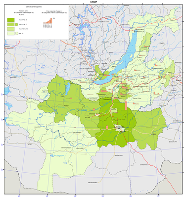
<p>The agricultural production is one of the leading sectors of the economic complex of Mongolia. Two branches are traditionally presented in the structure of the gross agricultural production; they are livestock husbandry and crop production. A specific feature of Mongolia is the predominance of livestock products and reliance on the pasture management system. On a national scale, the agriculture of the Baikal region of the Russian Federation holds a modest place: less than 1% of agricultural production. In the East Siberian economic region Irkutsk oblast ranks second in the production of agricultural products after Krasnoyarsk krai; the Republic of Buryatia and Zabaikalsky krai rank third and fourth, respectively. Among the regions, included into the Siberian Federal District, Irkutsk oblast, the Republic of Buryatia, and Zabaikalsky krai rank 5th, 8th and 9thin the agricultural production, respectively. In the economy of Irkutsk oblast the agriculture plays a minor role. Its aim is to meet the needs of the local population in agricultural products. In Zabaikalsky krai and the Republic of Buryatia the agriculture is one of the leading production branches, which plays a key role in the livelihood of the population. The branch accounts for about 8.1% of the gross regional product in Irkutsk oblast, 12% - in Zabaikalsky krai, and 11.5% - in the Republic of Buryatia.</p>
<p>The agriculture develops under extreme environmental conditions: the agricultural territory belongs mainly to an area of ​​low biological activity, andits significant part is characterized by cold climate. Bioclimatic potential of the agricultural zone is 2-2.5 times lower than in the European agricultural zone. Consequently, to get a unit of agricultural production in the region requires more energy expenditures.</p>
<p>The agriculture of regions within the Lake Baikal basin includes two major branches, namely: livestock hus band dry and crop production, the shares of which in the gross agricultural output vary regionally: in Irkutsk oblast they are approximately equal; in Zabaikalsky krai, the Republic of Buryatia and Mongolia the leading branch of agriculture is livestock husbandry, the proportion of which is over 70%.</p>
<p>Areas of agricultural lands, which are in use by commercial farm units, engaged in the agricultural production, decrease year by year. Disposal of agricultural lands from agriculture is registered in almost all districts of the region. The main reason for the reduction of lands dedicated to agricultural production is the termination of activities of enterprises and organizations, and peasant farms. Another reason is the expiration of the agricultural tenancy (or temporary use) and its non-renewal by agricultural producers.</p>
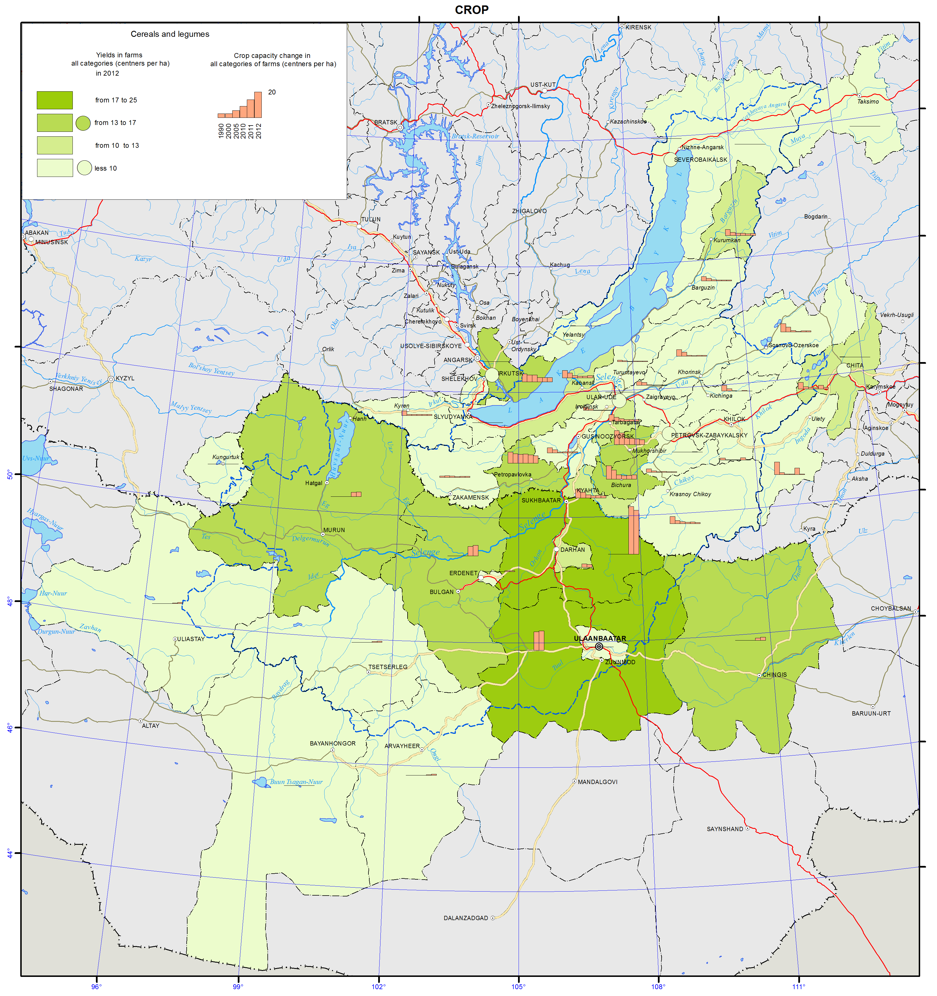
<p>About 1% of agricultural lands of Russia are located within the Baikal region. The main agricultural lands are located in the forest-steppe areas and along river valleys. However, the provision of the population with agricultural lands per capita is sufficient, for example, in Irkutsk oblastit amounts to 1.1 ha, and in Zabaikalsky krai it is 6 ha (average provision index for Russia is 1.5 ha). In the total area of agricultural lands of Irkutsk oblast the share of arable lands accounts for 69%, the proportion of pastures is 20%, and meadows and hayfields cover 10%. In Zabaikalsky krai the largest areas are occupied by forage lands, meadows and hayfields, the proportion of which exceeds 80%. In the structure of agricultural lands of the Republic of Buryatia the share of arable lands is 30%. Sown lands are used mainly for cereal crops (more than 75%), among which wheat occupies more than 45%. The yield of cereals on the average is low (8-9 centners per ha), but in some farms it can reach up to 20 and more centners per ha. Potatoes and vegetables are widely cultivated for one’s own needs. Sown lands under these crops amount to slightly more than 8%, of them under vegetables is 1.0%. Vegetable production is concentrated mainly around cities and settlements. In Irkutsk oblast in the Baikal natural territory lands of four districts, namely, Irkutsky, Shelekhovsky, Slyudyansky and Olkhonsky, are involved into the agricultural exploitation. Furthermore, two districts –Olkhonsky and Irkutsky – are typically “agricultural”, where agriculture is one of the leading sectors of the economic complex. In contrast to the Irkutsky and Olkhonsky districts, in the Sludyansky district the scarcity of land resources does not allow to develop agricultural production, but the district has formed a high-intensity horticultural sector with commercial cultivation of strawberries. Currently, this resource is not included in the turnover of the legal economy of the district; it is not processed on a commercial scale, and it is realized by private buyers, who do not pay taxes. Processing of local horticultural resources is included in the plan of the production diversification in the town of Baikalsk within the framework of the program of the Baikalsk Pulp and Paper Mill conversion. In Mongolia, the total sown areas of ​​cereal crops and potatoes amount to 283.6 thousand ha and 13.6 thousand ha, respectively. Currently, the leaders in the production of cereals and potatoes are the Selenge and Bulgan aimaks.</p>
<p>In the structure of the gross agricultural output a quintessential role belongs to the livestock husbandry. The development of the livestock husbandry, especially sheep and beef cattle breeding, is facilitated by the presence of large areas of dry grazing lands, where valuable forage herbs grow, and by a thin snow cover in winter, enabling year-round cattle grazing along with relatively small quantities of fodder procured for winter. In the structure of the fodder base for all species the proportion of natural coarse and green forage accounts for 75 to 85% of all fodder. The foundation stock of farm animals is managed in the private sector. The livestock husbandry is represented by various branches; in the forest area of the region it is dairy-meat farming, and in the south, including Mongolia, it is distant-pasture beef-dairy and beef cattle breeding, meat-wool sheep breeding, and horse and pig husbandry. Moreover, goat breeding is traditionally represented in the aimaks of Mongolia, and camel husbandry is an auxiliary branch. Most farms produce milk and beef, implementing the so-called full cycle of a herd based on internal specialization of farms, producing milk and breeding young-stock.</p>]]></content:encoded>
    <dc:publisher>No publisher</dc:publisher>
    <dc:creator>Alexander Ayurzhanaev</dc:creator>
    <dc:rights></dc:rights>
    <dc:date>2014-10-09T02:50:00Z</dc:date>
    <dc:type>Page</dc:type>
  </item>


  <item rdf:about="http://bic.iwlearn.org/en/atlas/atlas/66-animal-industry-map/animal-industry-map">
    <title>Animal industry map</title>
    <link>http://bic.iwlearn.org/en/atlas/atlas/66-animal-industry-map/animal-industry-map</link>
    <description></description>
    <content:encoded xmlns:content="http://purl.org/rss/1.0/modules/content/"><![CDATA[<p><img class="image-inline" src="../../../resolveuid/1231dff299c8448f95fae9f5bc59b31d/@@images/image/preview" /></p>
<p><a href="http://bic.iwlearn.org/en/atlas/photos/copy_of__66_Animalindustry.png" class="internal-link">Open full size</a></p>
<p align="center"><strong>The use of agricultural lands: livestock husbandry and crop production</strong></p>
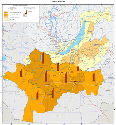
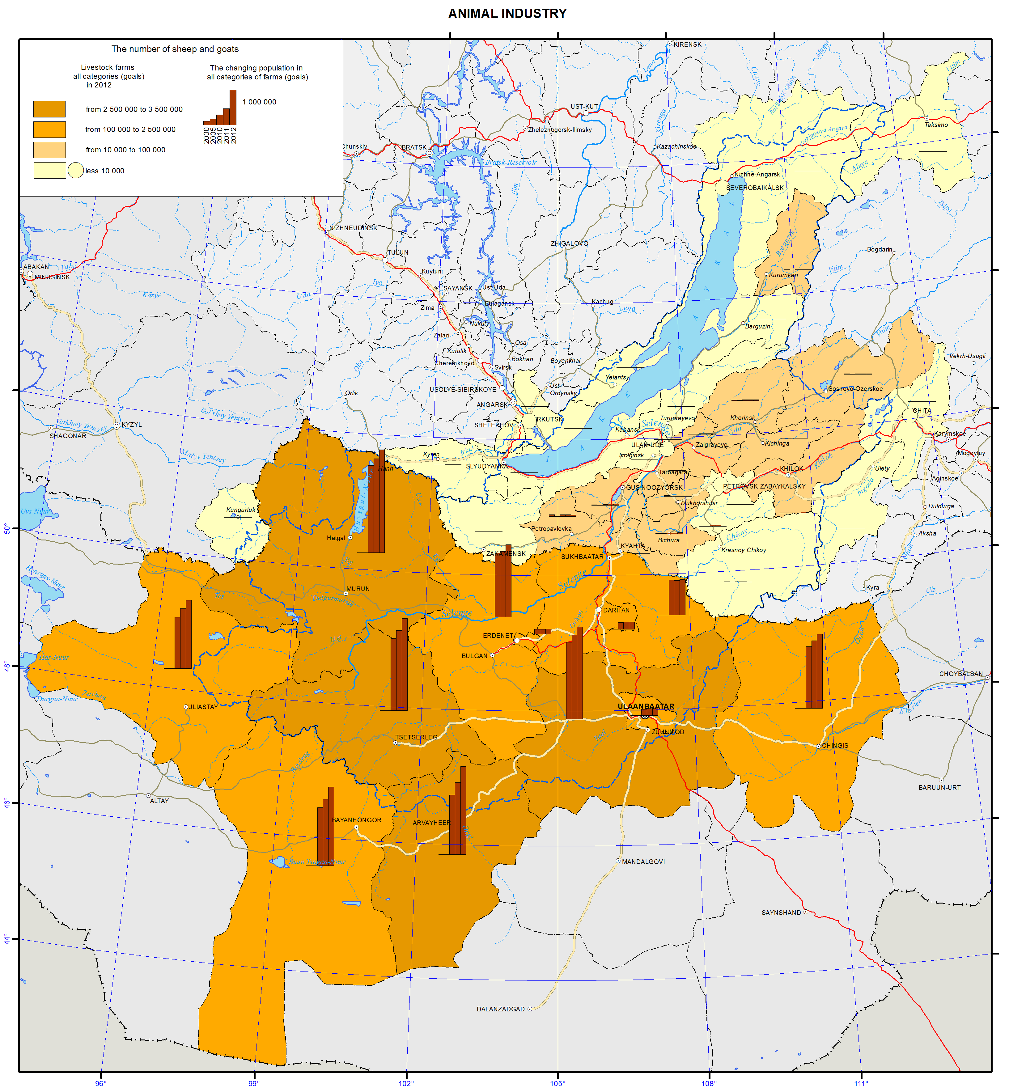
<p>The agricultural production is one of the leading sectors of the economic complex of Mongolia. Two branches are traditionally presented in the structure of the gross agricultural production; they are livestock husbandry and crop production. A specific feature of Mongolia is the predominance of livestock products and reliance on the pasture management system. On a national scale, the agriculture of the Baikal region of the Russian Federation holds a modest place: less than 1% of agricultural production. In the East Siberian economic region Irkutsk oblast ranks second in the production of agricultural products after Krasnoyarsk krai; the Republic of Buryatia and Zabaikalsky krai rank third and fourth, respectively. Among the regions, included into the Siberian Federal District, Irkutsk oblast, the Republic of Buryatia, and Zabaikalsky krai rank 5th, 8th and 9thin the agricultural production, respectively. In the economy of Irkutsk oblast the agriculture plays a minor role. Its aim is to meet the needs of the local population in agricultural products. In Zabaikalsky krai and the Republic of Buryatia the agriculture is one of the leading production branches, which plays a key role in the livelihood of the population. The branch accounts for about 8.1% of the gross regional product in Irkutsk oblast, 12% - in Zabaikalsky krai, and 11.5% - in the Republic of Buryatia.</p>
<p>The agriculture develops under extreme environmental conditions: the agricultural territory belongs mainly to an area of ​​low biological activity, andits significant part is characterized by cold climate. Bioclimatic potential of the agricultural zone is 2-2.5 times lower than in the European agricultural zone. Consequently, to get a unit of agricultural production in the region requires more energy expenditures.</p>
<p>The agriculture of regions within the Lake Baikal basin includes two major branches, namely: livestock hus band dry and crop production, the shares of which in the gross agricultural output vary regionally: in Irkutsk oblast they are approximately equal; in Zabaikalsky krai, the Republic of Buryatia and Mongolia the leading branch of agriculture is livestock husbandry, the proportion of which is over 70%.</p>
<p>Areas of agricultural lands, which are in use by commercial farm units, engaged in the agricultural production, decrease year by year. Disposal of agricultural lands from agriculture is registered in almost all districts of the region. The main reason for the reduction of lands dedicated to agricultural production is the termination of activities of enterprises and organizations, and peasant farms. Another reason is the expiration of the agricultural tenancy (or temporary use) and its non-renewal by agricultural producers.</p>
<p>About 1% of agricultural lands of Russia are located within the Baikal region. The main agricultural lands are located in the forest-steppe areas and along river valleys. However, the provision of the population with agricultural lands per capita is sufficient, for example, in Irkutsk oblastit amounts to 1.1 ha, and in Zabaikalsky krai it is 6 ha (average provision index for Russia is 1.5 ha). In the total area of agricultural lands of Irkutsk oblast the share of arable lands accounts for 69%, the proportion of pastures is 20%, and meadows and hayfields cover 10%. In Zabaikalsky krai the largest areas are occupied by forage lands, meadows and hayfields, the proportion of which exceeds 80%. In the structure of agricultural lands of the Republic of Buryatia the share of arable lands is 30%. Sown lands are used mainly for cereal crops (more than 75%), among which wheat occupies more than 45%. The yield of cereals on the average is low (8-9 centners per ha), but in some farms it can reach up to 20 and more centners per ha. Potatoes and vegetables are widely cultivated for one’s own needs. Sown lands under these crops amount to slightly more than 8%, of them under vegetables is 1.0%. Vegetable production is concentrated mainly around cities and settlements. In Irkutsk oblast in the Baikal natural territory lands of four districts, namely, Irkutsky, Shelekhovsky, Slyudyansky and Olkhonsky, are involved into the agricultural exploitation. Furthermore, two districts –Olkhonsky and Irkutsky – are typically “agricultural”, where agriculture is one of the leading sectors of the economic complex. In contrast to the Irkutsky and Olkhonsky districts, in the Sludyansky district the scarcity of land resources does not allow to develop agricultural production, but the district has formed a high-intensity horticultural sector with commercial cultivation of strawberries. Currently, this resource is not included in the turnover of the legal economy of the district; it is not processed on a commercial scale, and it is realized by private buyers, who do not pay taxes. Processing of local horticultural resources is included in the plan of the production diversification in the town of Baikalsk within the framework of the program of the Baikalsk Pulp and Paper Mill conversion. In Mongolia, the total sown areas of ​​cereal crops and potatoes amount to 283.6 thousand ha and 13.6 thousand ha, respectively. Currently, the leaders in the production of cereals and potatoes are the Selenge and Bulgan aimaks.</p>
<p>In the structure of the gross agricultural output a quintessential role belongs to the livestock husbandry. The development of the livestock husbandry, especially sheep and beef cattle breeding, is facilitated by the presence of large areas of dry grazing lands, where valuable forage herbs grow, and by a thin snow cover in winter, enabling year-round cattle grazing along with relatively small quantities of fodder procured for winter. In the structure of the fodder base for all species the proportion of natural coarse and green forage accounts for 75 to 85% of all fodder. The foundation stock of farm animals is managed in the private sector. The livestock husbandry is represented by various branches; in the forest area of the region it is dairy-meat farming, and in the south, including Mongolia, it is distant-pasture beef-dairy and beef cattle breeding, meat-wool sheep breeding, and horse and pig husbandry. Moreover, goat breeding is traditionally represented in the aimaks of Mongolia, and camel husbandry is an auxiliary branch. Most farms produce milk and beef, implementing the so-called full cycle of a herd based on internal specialization of farms, producing milk and breeding young-stock.</p>]]></content:encoded>
    <dc:publisher>No publisher</dc:publisher>
    <dc:creator>Alexander Ayurzhanaev</dc:creator>
    <dc:rights></dc:rights>
    <dc:date>2014-10-09T02:45:00Z</dc:date>
    <dc:type>Page</dc:type>
  </item>


  <item rdf:about="http://bic.iwlearn.org/en/atlas/atlas/65-construction-map/construction-map">
    <title>Construction map</title>
    <link>http://bic.iwlearn.org/en/atlas/atlas/65-construction-map/construction-map</link>
    <description></description>
    <content:encoded xmlns:content="http://purl.org/rss/1.0/modules/content/"><![CDATA[<p><img class="image-inline" src="../../../resolveuid/8417731d026043d89b5977e9bbd4e6c2/@@images/image/preview" /></p>
<p><a href="http://bic.iwlearn.org/en/atlas/photos/copy_of__65_Construction.png" class="internal-link">Open full size</a></p>
<p align="center"><strong>Construction</strong></p>
<p align="center"><strong> </strong></p>
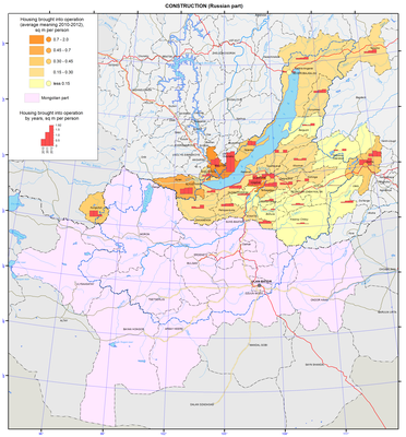
<p>Construction industry in the Baikal basin is one of the growth points of its economy and ecological well-being. One of the main indicators of the construction industry is the square meterage of the built civil and industrial facilities. Generally, it reflects its social and economic status in some regions. A current characterization of a segment of the construction sector – the residential construction – is conducted based on the observation of governmental statistical data [Districts…, 2013; Construction in Zabaikalsky krai, 2013; Construction in Russia, 2012; Construction and commissioning…, 2013] and the Internet resources [Federal State Statistics Service].</p>
<p>In the past three years (2010 to 2012), construction put-in-place increased three-fold (from 0.4 to 1.2 million sq. m). Judging by the growth of the absolute values of the residential construction put-in-place, Irkutsk oblast – the most urbanized region in the basin – tops the list with over a half of the volume of commissioned residential housing in the Baikal basin (2012).  The Republic of Buryatia is the second (26.2 %), and Zabaikalsky krai is the third (19.3 %).</p>
<p>The most important characteristics of residential development is the annual square meterage of the built housing (m²/person), which is presented as a background indicator of the map. By absolute indicators, Russia reached the pre-reform level of residential development in 2007. However, the specific indicator of the floor space of commissioned housing both in the country in general and in the Baikal basin in particular does not exceed 0.5 m²/person (in developed countries the annual construction capacity is at least 1 m² per capita, while the annual growth of housing put-in-place is 4.5-5.0 %) [Federal State Statistics Service]. Territorial differentiation of municipalities of the region according to this important indicator is quite contrasting. High specific indicators and the stable growth dynamics as a result of the implementation of targeted state programs facilitating residential development are observed across the whole territory except for the Republic of Tuva. Irkutsk oblast is leading, with its indicators being twice as high as the indicators of other regions (0.81 m²/person against the average regional indicator of 0.45 m²/person).</p>
<p>The residential construction sector of the region is distinguished by:</p>
<p>− The contrasting nature of its geography both in absolute and standard specific basic values;</p>
<p>− The current focal points of growth – Irkutsk and the Ivolginsky district (Republic of Buryatia).</p>
<p>The most important instruments for improving residential development are targeted state programs of regional and municipal levels. These programs focus on the implementation of comprehensive measures for the development of large-scale residential construction in the region. The key “driver” of the so-needed residential development in the municipalities of the lower level is the social and economic planning using various regional programs.</p>
<p align="center"> </p>
<p align="center">References</p>
<p>Statistical Compendium. (2013). <i>Districts of the Republic of Buryatia</i>. Ulan-Ude: Buryatstat. p 102.</p>
<p>Statistical Compendium. (2013). <i>Construction in Zabaikalsky krai</i>. Chita: Zabaikalkraistat. p 47.</p>
<p>Statistical Compendium. (2012). <i>Construction in Russia</i>. Moscow: Rosstat. p 220.</p>
<p>Statistical Compendium. (2013). <i>Construction and commissioning of facilities in Irkutsk oblast</i>. Irkutsk: Irkutskstat. p 36.</p>
<p>Federal State Statistics Service. <i>Database of municipal indicators</i>. Retrieved from http://www.gks.ru/dbscripts/munst/munst.htm</p>]]></content:encoded>
    <dc:publisher>No publisher</dc:publisher>
    <dc:creator>Alexander Ayurzhanaev</dc:creator>
    <dc:rights></dc:rights>
    <dc:date>2014-10-09T02:35:00Z</dc:date>
    <dc:type>Page</dc:type>
  </item>


  <item rdf:about="http://bic.iwlearn.org/en/atlas/atlas/64-industry-and-its-environmental-impact-map/industry-and-its-environmental-impact-map">
    <title>Industry and Its environmental impact map</title>
    <link>http://bic.iwlearn.org/en/atlas/atlas/64-industry-and-its-environmental-impact-map/industry-and-its-environmental-impact-map</link>
    <description></description>
    <content:encoded xmlns:content="http://purl.org/rss/1.0/modules/content/"><![CDATA[<p><img class="image-inline" src="../../../resolveuid/d05b4397c3f24c3bb86e32d2904c4076/@@images/image/preview" /></p>
<p><a href="http://bic.iwlearn.org/en/atlas/photos/copy_of__64_IndustryandItsEnvironmentalImpact.png" class="internal-link">Open full size</a></p>
<p align="center"><strong>Industrial and its impact on the environment</strong></p>
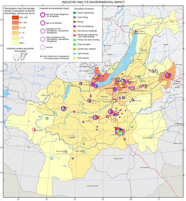
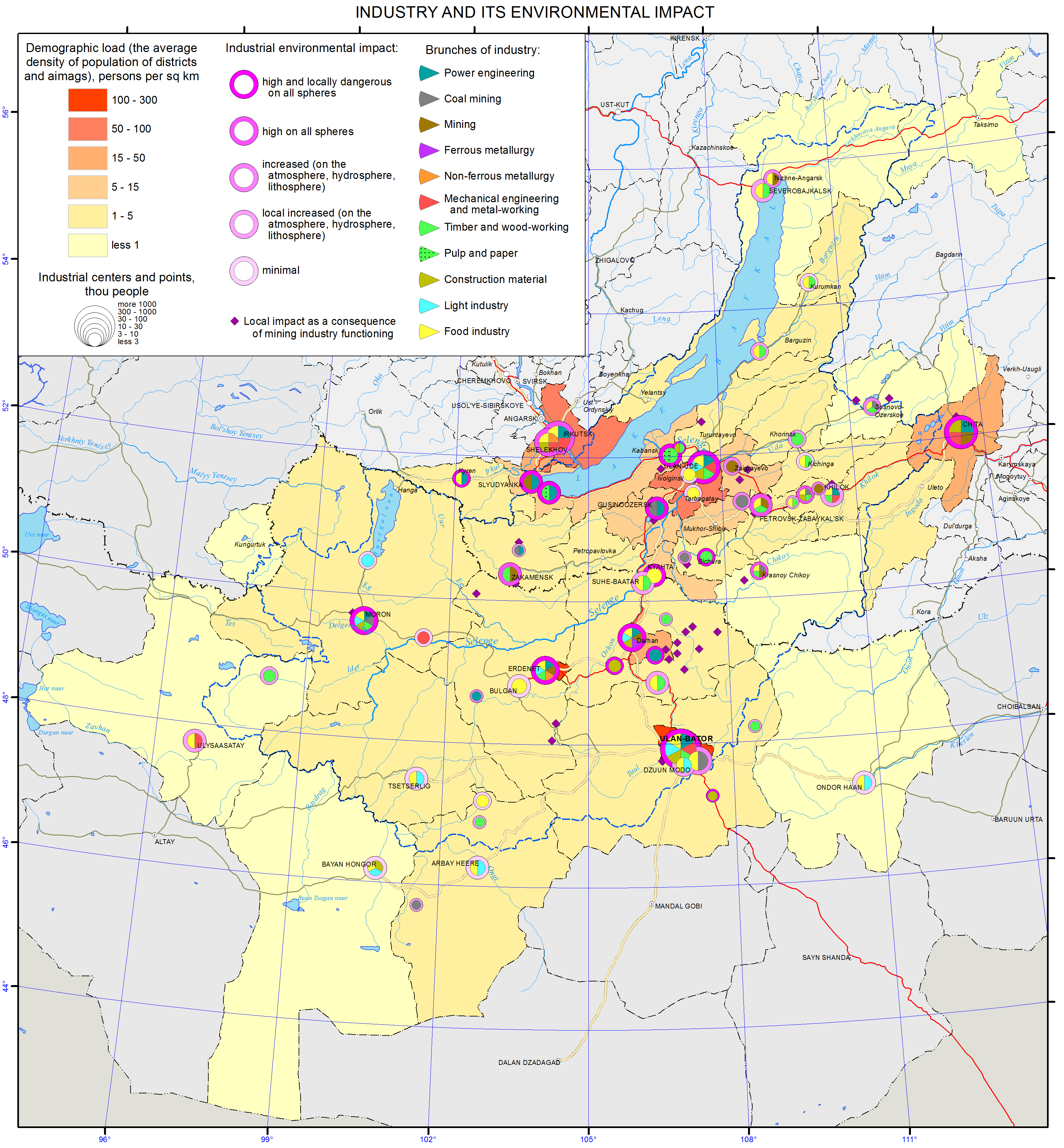
<p>Today, economic activity significantly influences the environment, and the main impact factor is the industry. The higher the concentration of industrial facilities, the more extensive the area of environmental changes is. This can be seen in the Baikal basin. Any change in one of the areas of the environment is reflected in the other (lithosphere disturbances indirectly affect the surface water and groundwater regimes, predetermining the dust and gas pollution, etc.).</p>
<p>The map “Industry and its impact on the environment” presents the results of the research of the industrial impact on the environment in the Baikal basin. The object of the map is an industrial center, as it is one of the most common forms of the territorial organization of industrial production representing a local group of companies (within the boundaries of a settlement).</p>
<p>The map depicts industrial centers with symbols. The symbol’s size shows the total population, the inner sectors – industry branches, circled sectors – the dominant impact on the environmental components. The areas disturbed by the mining industry (open-pits, waste heaps, dumps, etc.) and emissions (for large settlements) are shown separately. The areas with a maximum impact on the environment are identified based on the analysis of the industry’s impact on different environments.</p>
<p>The research results make it possible to draw the following conclusions.</p>
<p>The maximum industry impact on the environment is registered in the Republic of Buryatia. The impact on the environment is observed in all its settlements. The areas of the maximum negative impact on all environments are the Zakamensky, Kyakhtinsky, Gusinoozersky, Nizhne-Selenginsky and Ulan-Ude industrial hubs.</p>
<p>Major industries have negative impacts, e.g. the fuel and energy, mining, pulp and paper, and food industries. The main pollutants are the Ulan-Ude Central Heating Power Plant (CHPP)-1, Aviation Plant, Locomotive Repair Plant, glass factory, Selenginsky Pulp and Cardboard Mill, as well as light and food industries. Large and medium-sized waste dumps of consumer and industrial waste also significantly damage the environment [Impact...].</p>
<p>In Zabaikalsky krai, there is a local impact on the environment by the electrical energy, mining, and food industries. The largest area of a negative impact on the environment is the Chita industrial hub, where the main polluters are fuel-and-energy companies (the Chita Thermal Power Plant (TPP)-1 and TPP -2), mechanical engineering and metalworking plants, and transportation.</p>
<p>Industrial development in the part of Irkutsk oblast included into the Baikal basin is rather weak with the exception of the towns of Baikalsk and Slyudyanka. Here, the main polluters are mining (marble mining), transportation, and energy companies. In Baikalsk, the main source of pollution – the Baikalsk Pulp and Paper Mill – is currently closed, but the consequences of its activities in the form of pollution of the adjacent portion of the lake and the huge volume of stockpiled solid wastes still remain. Fuel and energy companies and transportation still significantly contribute to the air pollution. The administrative center of Irkutsk oblast – Irkutsk – has been continuously listed as one of the most polluted cities. The main air pollutants in Irkutsk are vehicle exhaust gas (52% of emissions) and unfiltered thermal power supply (46% of emissions). Manufacturing is responsible for about 2% of all emissions. Under certain circulatory patterns, some portion of atmospheric pollutants from Irkutsk can get into the Baikal basin and the lake’s water area. Therefore, according to the environmental zoning, this city is included into the zone of atmospheric impact. Irkutsk Aviation Plant is the main source of wastewater discharge into the Angara river, while the Irkutsk Furniture Factory — into the Irkut river. However, this pollution does not get into the Baikal catchment area. A growing number of unauthorized landfill sites around the city represents a particular problem. In the Olkhon district, the major source of environmental pollution is recreational activity resulting in the problem associated with the disposal of solid waste.</p>
<p>In Mongolia, among the main areas of industrial impact on the environment are industrial centers, where the majority of population is concentrated and industrial enterprises are located (Ulaanbaatar, Darkhan, Erdenet, etc.), as well as local mining areas and light industry companies (wool and leather processing). In Mongolia, the impact of industry on water resources is particularly acute. In the last 20 years, out of five thousand rivers and lakes 852 rivers and 1,131 lakes have dried up due to mining [Basayev]. In addition, intensive water pollution (water quality of Pollution Class 3-4) is observed in all selected areas and large industrial centers. The main water pollutants are oil products and phenols. Increased oxidation is also registered.</p>
<p>Uneven economic development of the territory is accompanied by an unequal impact on the environment. As a result, the most negative impact takes place in large industrial centers with a high concentration of industrial enterprises that are characterized by significant emissions of air pollutants and large-volume wastewater discharges. The natural resources potential of the area has determined the development of the mining industry, which poses the greatest risk of pollution by toxic substances from tailings ponds to the land and surface and groundwater.<b></b></p>
<p> </p>
<p align="center">References</p>
<p>The Information Portal Lake Baikal.<i> Impact of economic activities on the environment</i>. Retrieved from http://www.baikal-center.ru/books/element.php?ID=1387#</p>
<p>Basayev, S. Gold Rush in Mongolia hurts Lake Baikal. <i>Buryatia.Asia. </i>Retrieved from <a href="http://buryatia.asia/zolotodobyvayushhaya-promyshlennost-mongolii-udarila-po-ekologii-ozera-bajkal/">http://buryatia.asia/zolotodobyvayushhaya-promyshlennost-mongolii-udarila-po-ekologii-ozera-bajkal/</a></p>]]></content:encoded>
    <dc:publisher>No publisher</dc:publisher>
    <dc:creator>Alexander Ayurzhanaev</dc:creator>
    <dc:rights></dc:rights>
    <dc:date>2014-10-09T02:30:00Z</dc:date>
    <dc:type>Page</dc:type>
  </item>


  <item rdf:about="http://bic.iwlearn.org/en/atlas/atlas/63-environmental-functions-map/environmental-functions-map">
    <title>Environmental functions map</title>
    <link>http://bic.iwlearn.org/en/atlas/atlas/63-environmental-functions-map/environmental-functions-map</link>
    <description></description>
    <content:encoded xmlns:content="http://purl.org/rss/1.0/modules/content/"><![CDATA[<p><img class="image-inline" src="../../../resolveuid/a8df77559e8b4619b64773bf33684f76/@@images/image/preview" /></p>
<p><a href="http://bic.iwlearn.org/en/atlas/photos/copy_of__63_Environmentalfunctions.png" class="internal-link">Open full size</a></p>
<p align="center"><strong>Ecological functions of landscapes</strong></p>
<p align="center"><strong> </strong></p>
<p>This map represents the groups of landscapes with similar nature protecting (ecological) functions [Polikarpov et al., 1980, p. 184-194]. They are divided into groups depending on these functions: environment-forming function of geospheric and regional significance, environment-regulating, environment-stabilising, and environment-protective.</p>
<p>The landscapes of goletz, tundra and sparse wood perform the main environment-forming “water-production” function. Of special significance is their snow and water collecting function. These landscapes experience large hydrological loads as they transform the water and transfer it to the subsurface flow. To date, the production of pure water is the most important ecological function as pure water is becoming the most valuable product on the planet. The significance of these landscapes increases due to the protection of depth and purity of Lake Baikal waters.</p>
<p>The environment-stabilizing function is characteristic of all mountain-taiga (moss) landscapes of reduced and limited development – from mountain-taiga shrub-moss dark coniferous and larch communities to shrub and moss-shrub dark coniferous and larch-taiga landscapes in the intermountain depression and valleys with yernik and mixed undergrowth. Their moss cover provides certain ecological conditions. These landscapes are more stable and after external pressure they, as a rule, recover fast. Together with goletz and upper-taiga landscapes, they determine the fundamental set of mechanisms of internal and external interactions of landscapes.</p>
<p>South Siberian and Central Asian (Daurian-Mongolian) steppe landscapes are referred to the group with environment-regulating functions. On the whole, they are characterized by insufficient wetness [Geosystems …, 1991; Eco-geographic …, 1996]. Their role in the flow regulation is rather small. However, under conditions of intense water evaporation they have a very important regulating significance: plant components of these landscapes support the existing ecological balance whose changes can cause the disturbance of the moisture regime and, as a result, the landscape structure. This function specifically intensifies under the conditions of anthropogenic pressure. As a result, all steppe landscapes share high soil-protective significance as they fulfil a technogenic barrier function.</p>
<p>“Herb” landscapes perform environment-protective function: mountain-taiga larch landscapes of optimal development, piedmont and larch-taiga landscapes of optimal development in intermountain depressions, piedmont sub-taiga larch, mountain-taiga pinewood, piedmont sub-taiga pinewood landscapes. Insufficient moistening is characteristic of these landscapes, and changes of their vegetative component can cause changes in hydrological regime towards aridity and, as a result, disruption of landscape structure. Their water and soil-protective role increases. They are characterised by high concentration of different economic activity. Therefore, these landscapes are of technogenic barrier significance.</p>
<p><b> </b></p>
<p align="center"><b>References</b></p>
<p><i>Atlas of Irkutsk Oblast: Ecological Conditions for Development</i>. (2004) – M. – Irkutsk,. – 90 p.</p>
<p><i>Geosystems of taiga and steppe contact: South of Central Siberia</i>. (1991) / Chief Ed. A. Krauklis. – Novosibirsk: Nauka. – 214 p.</p>
<p>Isachenko, A.G. (1990). Intensity of functioning and productivity of geosystems // <i>Izv. AS USSR. Ser. Geogr.</i>– 5. – P. 5-17.</p>
<p>Correlation eco-phytocoenotic map, scale 1:7,500,000. (1977). / Buks I.I., Baiborodin V.N., Timirbaeva L.S. // <i>Eco-phytocoenotic complexes of Asian Russia (mapping experience)</i>. – Irkutsk.</p>
<p>Landscapes of South-East Siberia: map, scale 1:1,500,000 (1977). / Mikheev, V.S., Ryashin, V.A. – M.: GUGK, – 4 p.</p>
<p>Mikheev, V.C. (1987). <i>Landscape and geographic supply of Siberian complex problems.</i> – Novosibirsk: Nauka. Sib. Depart. – 205 p.</p>
<p>Mikheev, V.C. (1988). <i>Materials for territorial complex scheme of nature protection (TerKSOP)</i>. – Irkutsk. – 63 p.</p>
<p><i>National Atlas of Mongolian People’s Republic.</i> (1990). Ulan-Bator-Moscow. –  144 p.</p>
<p>Polikarpov, N.P.,. Chebakova, N.M, Nazimova, D.I. (1980). <i>Climate and mountain forests of South Siberia</i>. – Novosibirsk: Nauka. – 225 p.</p>
<p>Sochava, V.B. (2005). <i>Theoretical and applied geography. Selected Proceedings</i> / V.B. Sochava. – Novosibirsk: Nauka. – 288 p.</p>
<p><i>Eco-geographic map of the Russian Federation: map, scale 1:4,000,000.</i> (1996). – M.: Fed. Service of Geodesy and Cartography of Russia. – 4 p.</p>]]></content:encoded>
    <dc:publisher>No publisher</dc:publisher>
    <dc:creator>Alexander Ayurzhanaev</dc:creator>
    <dc:rights></dc:rights>
    <dc:date>2014-10-09T02:20:00Z</dc:date>
    <dc:type>Page</dc:type>
  </item>


  <item rdf:about="http://bic.iwlearn.org/en/atlas/atlas/60-environmental-landscapes-map/environmental-landscapes-map">
    <title>Environmental landscapes  map</title>
    <link>http://bic.iwlearn.org/en/atlas/atlas/60-environmental-landscapes-map/environmental-landscapes-map</link>
    <description></description>
    <content:encoded xmlns:content="http://purl.org/rss/1.0/modules/content/"><![CDATA[<p><img class="image-inline" src="../../../resolveuid/f3ef729f165c401482e6b4eb394f24f1/@@images/image/preview" /></p>
<p><a href="http://bic.iwlearn.org/en/atlas/photos/copy_of__60_Environmentallandscapes.png" class="internal-link">Open full size</a></p>
<p align="center"><b>Environment resources: ecological resources of landscapes in the </b><b>B</b><b>aikal basin</b></p>
<p>This package contains small-scale overview maps with the most common patterns of ecological resources of landscapes in the Baikal basin. The definition “ecological resource”, which is identical to the definition “ecological potential”, means the ability of landscapes to provide people with all necessary conditions for existence, i.e. to create specific local environment.</p>
<p>The structure of the map package was developed as applicable to the solution of practical problems of information support of regional programmes on rational use and protection of natural landscapes. The information base of the package consists of literature sources [Geosystems …, 1991; Isachenko, 1990; Mikheev, 1987, 1988; Polikarpov et al., 1980; Sochava, 2005], cartographic material [Atlas …, 2004; National Atlas …, 1990; Correlation …, 1977; Landscapes …, 1977; Eco-geographic …, 1996] and Internet resources. <b> </b></p>
<p><b> </b></p>
<p align="center"> </p>
<p align="center"><b>Landscape-ecological complexes</b></p>
<p>This map is a mosaic of 16 structural landscape subdivisions belonging to 2 subcontinents (Northern and Central Asia) and 3 types of natural conditions (arctic-boreal, semiarid and arid) [Geosystems …, 1991].</p>
<p>Typological classification of landscapes (goletz, subgoletz, upper taiga, taiga, subtaiga and steppe) reflects altitude-zonal differentiation of environmental conditions, as well as depression and piedmont effects of their manifestation. Regional range of landscapes classification (Baikal-Dzhugdzhurskiye, South-Siberian, Central Asian, Khangaisko-Daurskiye, Srednekhalkhasko-Mongolian) includes sector differentiation of environmental conditions formed under the influence of prevailing air masses of different direction (mainly western and eastern transfer), as well as interpenetration and uniqueness of natural phenomena in the basin of Lake Baikal.</p>
<p>According to the material and energy exchange, the North-Asian goletz, taiga and subtaiga landscapes are subdivided into subgroups of natural conditions: extreme, reduced, limited and optimal development. South-Siberian and Central Asian steppe landscapes are subdivided into arid, dry and very dry landscapes depending on moisture supply of these landscapes.</p>
<p>The legend of the map also presents numerical values of integral intensity of landscape functioning (heat and moisture supply of landscapes and plant biological productivity) [Eco-geographic …, 1996]:</p>
<p>- heat supply (total mean daily temperatures over 10ºC): cold (600-800ºC), moderately cold (800-1200 ºC), moderately warm (1200-1600 ºC) and warm (1600-2000 ºC);</p>
<p>- moisture supply (radiation dryness index according to M. Budyko): perhumid (less than 0.5), humid (0.5-0.9),  subhumid (1.0-1.4), insufficiently humid (1.5-1.9), dry (2.0-2.4), and very dry (over 2.5);</p>
<p>- plant biological productivity (annual growth of plants at appropriate values of heat and moisture expressed in dry mass of organic matter of terrestrial and underground parts of plants): very low (less than 20 metric centners/ha), low (20-40 metric centners/ha), mean (40-60 metric centners/ha), elevated (60-80 metric centners/ha), and high (over 80 metric centners/ha).</p>
<p>This map is used as an interpretation basis for the development of derived assessment and recommendation maps of the environment.</p>]]></content:encoded>
    <dc:publisher>No publisher</dc:publisher>
    <dc:creator>Alexander Ayurzhanaev</dc:creator>
    <dc:rights></dc:rights>
    <dc:date>2014-10-09T01:55:00Z</dc:date>
    <dc:type>Page</dc:type>
  </item>


  <item rdf:about="http://bic.iwlearn.org/en/atlas/atlas/59-hunting-resources-map/hunting-resources-map">
    <title>Hunting resources. Wild fowl map</title>
    <link>http://bic.iwlearn.org/en/atlas/atlas/59-hunting-resources-map/hunting-resources-map</link>
    <description></description>
    <content:encoded xmlns:content="http://purl.org/rss/1.0/modules/content/"><![CDATA[<p><img class="image-inline" src="../../../resolveuid/c91994aa9d884df9be1a105391080f51/@@images/image/preview" /></p>
<p><a href="http://bic.iwlearn.org/en/atlas/photos/copy_of__59_Huntingresources.png" class="internal-link">Open full size</a></p>
<p align="center"><strong>Game animals</strong></p>
<p>The resource potential of game animals of the Baikal basin has long been characterized by the abundance and high species diversity. This is due to the location of the territory at the intersection of Central-Asian, European-Siberian and East-Asian faunas, where representatives of all of these complexes, including species valuable for hunting, are found. Within the region, there are four typological landscape complexes, corresponding to the zonal and regional landscape subdivisions, namely: mountain-taiga, goletz, forest-steppe, and steppe. Each of them is characterized by a set of habitat types, the quality and quantity of which influence the number of animals.</p>
<p>The wildlife of the <b><i>mountain taiga </i></b>is the richest and most diverse; there manifestations of latitudinal zonality in the distribution of vegetation are complicated by the features of altitudinal zonality of its location in the mountains depending on the steepness and exposure of slopes. This creates prerequisites to spread the spectrum of landscape-ecological diversity of the conditions of animal habitats, and possibilities for most of them to choose the most valuable biotopes and, eventually, to increase in the number. In the mountain taiga squirrel, hazel grouse, sable, bear, and in some places musk deer are numerous. Siberian stag and roe deer inhabiting light slopes, forest openings and woodlots, as well as elk, inhabiting waterlogged intermountain depressions, creek valleys and wide plots of terraces in the coastal area of Lake Baikal, are common. Wolf is numerous in some places; wood grouse and fox are common; lynx and wolverine are less common. Unique populations of reindeer and black-capped marmot survived in high-mountain belts of ridges on both sides of Lake Baikal thanks to the good protection.</p>
<p>Nerpa (Baikal seal) occupies a special place, being the only representative of the family of pinnipeds on Lake Baikal. Its largest rookery is located on the Malye Ushkanyi Islands.</p>
<p>The <b><i>goletz complex</i></b> is characterized by a significantly lower abundance of game animals. Willow and rock ptarmigan, reindeer and ermine belong to permanent residents. This complex can be roughly considered a complementing link to the mountain-taiga one since so many game animals, especially the ungulates, as well as bear, are connected with the highlands by systematic seasonal migrations.</p>
<p>The <b><i>forest-steppe and steppe complexes</i></b> stretch in narrow discontinuous bands in the south of the region. They are represented by the Central-Asian mountain steppes and are not distinguished by the abundance of game animals. Only roe deer in the forest-steppe continues to hold the background position among other species, while tarbagan, once numerous in the steppe, has lost its former significance as a result of plowing of the Transbaikalian steppes and its extermination as a carrier of epizootic plague in the course of antiplague measures. Other species characteristic of the forest-steppe zone, namely, badger and raccoon dog, and of the steppe zone, namely, tolai hare, manul, and dzeren, are small in number. Some of them (dzeren and manul) are protected.</p>
<p>The status of game animals is examined only for the Russian part of the Baikal basin. In connection with the reorganizational measures in the Russian hunting sector over the past two decades, some negative manifestations can be noticed in the usage patterns of species valuable for hunting and in the dynamics of their numbers. A number of problems arose, connected mainly with wild ungulates, especially Siberian stag, roe deer, elk, wild reindeer, and in some places musk deer. Concerning these species ​​an undisputed conclusion was made (as, indeed, for other regions) that “the current dynamics of populations of wild ungulates in Russia is determined mainly by hunters (poachers to a greater extent), large predators, and, locally, snowy winters, and not by a natural cyclicity and changes in the productivity of phytocenoses” [Kozhichev, 2002; Danilkin, 2010].</p>
<p>Among large predators the greatest harm is done by wolves. The wolf problem arose due to the loosening of its control. The damage from this predator to the ungulates (Siberian stag and, especially, roe deer) in different regions of Buryatia reaches 8-30% of the autumn herd [Noskov, 2008]. In recent years, in consequence of the irregular decrease in the number of Siberian stag (poaching and death by predators) in conjunction with the legal shooting in Buryatia a crisis situation with the population of this deer was created [Noskov, 2008]. The damage from wolves only in Transbaikalia in 2011 amounted to11.6 million roubles to agriculture and 70-80 million rubles to hunting [Samoilov, Kayukova, 2013]. Because of the large number of wolves in some areas of Transbaikalia an emergency situation was declared [Samoilov, Kayukova, 2013].</p>
<p>In the current situation, the negative effects are smoothed out to some extent through a network of specially protected natural areas. Thus, in Buryatia, 7-8% of the total number of Siberian stag and roe deer are protected within the territories of 13 nature reserves (zakazniks) and 3 reserved areas (zapovedniks) [Noskov, 2008]. Reindeer is listed in the Red Book of the Republic of Buryatia. Measures to protect the hunting grounds, especially in the areas of concentration of animals, are taken.</p>
<p>Another situation formed with respect to fur-bearing species of hunting. This is due to the fall in world prices for raw fur. Eighteen million pelts of caged mink from China were mass-marketed [Romanov, 2008]. Because of low prices for Chinese mink, squirrel or muskrat fur coats turned out to be more expensive. As a result, squirrel and muskrat are in little demand on the market. The same situation takes place with other species, namely: fox, Siberian weasel, and ermine. Rare lynx and wolverine pelts are used mainly on the domestic market.</p>
<p>A diametrically opposite situation is with sable enabling Russia to achieve a dominant position in the world market as an exclusive supplier of sable fur. Demand and prices for sable pelts have increased. The price for a sable at an auction averages 220-250 dollars. As opposed to the past years, sable is not endangered as there are less professional hunters. Besides, remote hunting lands are not utilized. They have become a kind of sable reserves, where sables multiply and settle throughout the taiga.</p>
<p>The analysis of the status of hunting fauna in the Baikal basin revealed a number of trends in the features of its use, also characteristic of other regions of the country, in particular, the problem of protecting ungulates. A positive phenomenon is a continued status of sable as the leader in the world fur market, and a removal of the danger of its extermination due to changes in socio-economic conditions, which is important in contrast with previous years.</p>
<p>At the same time, unlike the majority of Siberian regions where a trend of rapid increase in the area of publicly available lands accelerated, in the region under consideration this phenomenon is minimized. This is indicative of targeted optimization of the utilization of game animals resources on the basis of improving forms of hunting management and prospects of its development in the region. Thus, the calculations [Dambiev et al., 2011] made it possible to estimate the socio-economic significance of hunting nature management in the Republic of Buryatia in 2010 as amounting to 1.1 billion roubles. Among them natural products of hunting (furs, meat, etc.) are estimated at 150 million roubles, while the social impact of tourism associated with hunting reaches 450 million roubles. The remaining portion is accounted for by other socio-economic relevance. Therefore, the current state of game fauna in the study region is characterized as conditionally stable. As a result of satisfactory organization of protection of game animals in the region, their number corresponds to a primitive stage of market hunting management.<b></b></p>
<p align="center">References</p>
<p>Dambiev, A.G., Kambalin, V.S., and Noskov, V.T. (2011). <i>Hunting nature management of the Republic of Buryatia: problems and prospects.</i> Irkutsk: Izd-vo Irkutskoi  selskokhozyaistvennoi akademii. - 109 p.</p>
<p>Danilkin, A. (2010). <i>Wild ungulates of Russia: patterns of population dynamics, in Okhota i okhotnichie khozyaistvo</i>, no.10, pp. 1-4.</p>
<p>Kozhichev, R. (2002). Siberian roe deer in Irkutsk oblast: what to do? in <i>Okhota i okhotnichie khozyaistvo</i>, , no. 12, pp. 4-5.</p>
<p>Noskov, V.T. (2008). <i>Game animals of Buryatia</i>. Ulan-Ude: Izd-vo FGOU VP. “BGSKhA” im. V.V. Filippova, , 223 p.</p>
<p>Romanov, V.I. (2008). Organizational obstacles for producing hunting fur in Eastern Siberia in Protection and sustainable use of animal and plant resources. <i>Proceedings of the International Scientific Conference, May, 29 – June, 1, 2008</i>. Irkutsk: Izd-vo Irkutskoi selskokhozyaistvennoi akademii, pp. 134-136.</p>
<p>Samoilov, E.B. and Kayukova, S.N. (2013). <i>Invasion of wolves in Transbaikalia</i>.  Irkutsk: Izd-vo IrGSKhA, pp. 261-263.</p>]]></content:encoded>
    <dc:publisher>No publisher</dc:publisher>
    <dc:creator>Alexander Ayurzhanaev</dc:creator>
    <dc:rights></dc:rights>
    <dc:date>2014-10-09T01:55:00Z</dc:date>
    <dc:type>Page</dc:type>
  </item>


  <item rdf:about="http://bic.iwlearn.org/en/atlas/atlas/58-hunting-resources-map/hunting-resources-map">
    <title>Hunting resources. Squirrel and hare map</title>
    <link>http://bic.iwlearn.org/en/atlas/atlas/58-hunting-resources-map/hunting-resources-map</link>
    <description></description>
    <content:encoded xmlns:content="http://purl.org/rss/1.0/modules/content/"><![CDATA[<p><img class="image-inline" src="../../../resolveuid/e2a290cdf91246f7ba5244c4422504fd/@@images/image/preview" /></p>
<p><a href="http://bic.iwlearn.org/en/atlas/photos/copy_of__58_Huntingresources.png" class="internal-link">Open full size</a></p>
<p align="center"><strong>Game animals</strong></p>
<p>The resource potential of game animals of the Baikal basin has long been characterized by the abundance and high species diversity. This is due to the location of the territory at the intersection of Central-Asian, European-Siberian and East-Asian faunas, where representatives of all of these complexes, including species valuable for hunting, are found. Within the region, there are four typological landscape complexes, corresponding to the zonal and regional landscape subdivisions, namely: mountain-taiga, goletz, forest-steppe, and steppe. Each of them is characterized by a set of habitat types, the quality and quantity of which influence the number of animals.</p>
<p>The wildlife of the <b><i>mountain taiga </i></b>is the richest and most diverse; there manifestations of latitudinal zonality in the distribution of vegetation are complicated by the features of altitudinal zonality of its location in the mountains depending on the steepness and exposure of slopes. This creates prerequisites to spread the spectrum of landscape-ecological diversity of the conditions of animal habitats, and possibilities for most of them to choose the most valuable biotopes and, eventually, to increase in the number. In the mountain taiga squirrel, hazel grouse, sable, bear, and in some places musk deer are numerous. Siberian stag and roe deer inhabiting light slopes, forest openings and woodlots, as well as elk, inhabiting waterlogged intermountain depressions, creek valleys and wide plots of terraces in the coastal area of Lake Baikal, are common. Wolf is numerous in some places; wood grouse and fox are common; lynx and wolverine are less common. Unique populations of reindeer and black-capped marmot survived in high-mountain belts of ridges on both sides of Lake Baikal thanks to the good protection.</p>
<p>Nerpa (Baikal seal) occupies a special place, being the only representative of the family of pinnipeds on Lake Baikal. Its largest rookery is located on the Malye Ushkanyi Islands.</p>
<p>The <b><i>goletz complex</i></b> is characterized by a significantly lower abundance of game animals. Willow and rock ptarmigan, reindeer and ermine belong to permanent residents. This complex can be roughly considered a complementing link to the mountain-taiga one since so many game animals, especially the ungulates, as well as bear, are connected with the highlands by systematic seasonal migrations.</p>
<p>The <b><i>forest-steppe and steppe complexes</i></b> stretch in narrow discontinuous bands in the south of the region. They are represented by the Central-Asian mountain steppes and are not distinguished by the abundance of game animals. Only roe deer in the forest-steppe continues to hold the background position among other species, while tarbagan, once numerous in the steppe, has lost its former significance as a result of plowing of the Transbaikalian steppes and its extermination as a carrier of epizootic plague in the course of antiplague measures. Other species characteristic of the forest-steppe zone, namely, badger and raccoon dog, and of the steppe zone, namely, tolai hare, manul, and dzeren, are small in number. Some of them (dzeren and manul) are protected.</p>
<p>The status of game animals is examined only for the Russian part of the Baikal basin. In connection with the reorganizational measures in the Russian hunting sector over the past two decades, some negative manifestations can be noticed in the usage patterns of species valuable for hunting and in the dynamics of their numbers. A number of problems arose, connected mainly with wild ungulates, especially Siberian stag, roe deer, elk, wild reindeer, and in some places musk deer. Concerning these species ​​an undisputed conclusion was made (as, indeed, for other regions) that “the current dynamics of populations of wild ungulates in Russia is determined mainly by hunters (poachers to a greater extent), large predators, and, locally, snowy winters, and not by a natural cyclicity and changes in the productivity of phytocenoses” [Kozhichev, 2002; Danilkin, 2010].</p>
<p>Among large predators the greatest harm is done by wolves. The wolf problem arose due to the loosening of its control. The damage from this predator to the ungulates (Siberian stag and, especially, roe deer) in different regions of Buryatia reaches 8-30% of the autumn herd [Noskov, 2008]. In recent years, in consequence of the irregular decrease in the number of Siberian stag (poaching and death by predators) in conjunction with the legal shooting in Buryatia a crisis situation with the population of this deer was created [Noskov, 2008]. The damage from wolves only in Transbaikalia in 2011 amounted to11.6 million roubles to agriculture and 70-80 million rubles to hunting [Samoilov, Kayukova, 2013]. Because of the large number of wolves in some areas of Transbaikalia an emergency situation was declared [Samoilov, Kayukova, 2013].</p>
<p>In the current situation, the negative effects are smoothed out to some extent through a network of specially protected natural areas. Thus, in Buryatia, 7-8% of the total number of Siberian stag and roe deer are protected within the territories of 13 nature reserves (zakazniks) and 3 reserved areas (zapovedniks) [Noskov, 2008]. Reindeer is listed in the Red Book of the Republic of Buryatia. Measures to protect the hunting grounds, especially in the areas of concentration of animals, are taken.</p>
<p>Another situation formed with respect to fur-bearing species of hunting. This is due to the fall in world prices for raw fur. Eighteen million pelts of caged mink from China were mass-marketed [Romanov, 2008]. Because of low prices for Chinese mink, squirrel or muskrat fur coats turned out to be more expensive. As a result, squirrel and muskrat are in little demand on the market. The same situation takes place with other species, namely: fox, Siberian weasel, and ermine. Rare lynx and wolverine pelts are used mainly on the domestic market.</p>
<p>A diametrically opposite situation is with sable enabling Russia to achieve a dominant position in the world market as an exclusive supplier of sable fur. Demand and prices for sable pelts have increased. The price for a sable at an auction averages 220-250 dollars. As opposed to the past years, sable is not endangered as there are less professional hunters. Besides, remote hunting lands are not utilized. They have become a kind of sable reserves, where sables multiply and settle throughout the taiga.</p>
<p>The analysis of the status of hunting fauna in the Baikal basin revealed a number of trends in the features of its use, also characteristic of other regions of the country, in particular, the problem of protecting ungulates. A positive phenomenon is a continued status of sable as the leader in the world fur market, and a removal of the danger of its extermination due to changes in socio-economic conditions, which is important in contrast with previous years.</p>
<p>At the same time, unlike the majority of Siberian regions where a trend of rapid increase in the area of publicly available lands accelerated, in the region under consideration this phenomenon is minimized. This is indicative of targeted optimization of the utilization of game animals resources on the basis of improving forms of hunting management and prospects of its development in the region. Thus, the calculations [Dambiev et al., 2011] made it possible to estimate the socio-economic significance of hunting nature management in the Republic of Buryatia in 2010 as amounting to 1.1 billion roubles. Among them natural products of hunting (furs, meat, etc.) are estimated at 150 million roubles, while the social impact of tourism associated with hunting reaches 450 million roubles. The remaining portion is accounted for by other socio-economic relevance. Therefore, the current state of game fauna in the study region is characterized as conditionally stable. As a result of satisfactory organization of protection of game animals in the region, their number corresponds to a primitive stage of market hunting management.<b></b></p>
<p align="center">References</p>
<p>Dambiev, A.G., Kambalin, V.S., and Noskov, V.T. (2011). <i>Hunting nature management of the Republic of Buryatia: problems and prospects.</i> Irkutsk: Izd-vo Irkutskoi  selskokhozyaistvennoi akademii. - 109 p.</p>
<p>Danilkin, A. (2010). <i>Wild ungulates of Russia: patterns of population dynamics, in Okhota i okhotnichie khozyaistvo</i>, no.10, pp. 1-4.</p>
<p>Kozhichev, R. (2002). Siberian roe deer in Irkutsk oblast: what to do? in <i>Okhota i okhotnichie khozyaistvo</i>, , no. 12, pp. 4-5.</p>
<p>Noskov, V.T. (2008). <i>Game animals of Buryatia</i>. Ulan-Ude: Izd-vo FGOU VP. “BGSKhA” im. V.V. Filippova, , 223 p.</p>
<p>Romanov, V.I. (2008). Organizational obstacles for producing hunting fur in Eastern Siberia in Protection and sustainable use of animal and plant resources. <i>Proceedings of the International Scientific Conference, May, 29 – June, 1, 2008</i>. Irkutsk: Izd-vo Irkutskoi selskokhozyaistvennoi akademii, pp. 134-136.</p>
<p>Samoilov, E.B. and Kayukova, S.N. (2013). <i>Invasion of wolves in Transbaikalia</i>.  Irkutsk: Izd-vo IrGSKhA, pp. 261-263.</p>]]></content:encoded>
    <dc:publisher>No publisher</dc:publisher>
    <dc:creator>Alexander Ayurzhanaev</dc:creator>
    <dc:rights></dc:rights>
    <dc:date>2014-10-09T01:45:00Z</dc:date>
    <dc:type>Page</dc:type>
  </item>


  <item rdf:about="http://bic.iwlearn.org/en/atlas/atlas/57-hunting-resources-map/hunting-resources-map">
    <title>Hunting resources. Fur-bearing animals map</title>
    <link>http://bic.iwlearn.org/en/atlas/atlas/57-hunting-resources-map/hunting-resources-map</link>
    <description></description>
    <content:encoded xmlns:content="http://purl.org/rss/1.0/modules/content/"><![CDATA[<p><img class="image-inline" src="../../../resolveuid/cda03ffdcb44441cb11554ce5d32cbfd/@@images/image/preview" /></p>
<p>Open full size</p>
<p align="center"><strong>Game animals</strong></p>
<p>The resource potential of game animals of the Baikal basin has long been characterized by the abundance and high species diversity. This is due to the location of the territory at the intersection of Central-Asian, European-Siberian and East-Asian faunas, where representatives of all of these complexes, including species valuable for hunting, are found. Within the region, there are four typological landscape complexes, corresponding to the zonal and regional landscape subdivisions, namely: mountain-taiga, goletz, forest-steppe, and steppe. Each of them is characterized by a set of habitat types, the quality and quantity of which influence the number of animals.</p>
<p>The wildlife of the <b><i>mountain taiga </i></b>is the richest and most diverse; there manifestations of latitudinal zonality in the distribution of vegetation are complicated by the features of altitudinal zonality of its location in the mountains depending on the steepness and exposure of slopes. This creates prerequisites to spread the spectrum of landscape-ecological diversity of the conditions of animal habitats, and possibilities for most of them to choose the most valuable biotopes and, eventually, to increase in the number. In the mountain taiga squirrel, hazel grouse, sable, bear, and in some places musk deer are numerous. Siberian stag and roe deer inhabiting light slopes, forest openings and woodlots, as well as elk, inhabiting waterlogged intermountain depressions, creek valleys and wide plots of terraces in the coastal area of Lake Baikal, are common. Wolf is numerous in some places; wood grouse and fox are common; lynx and wolverine are less common. Unique populations of reindeer and black-capped marmot survived in high-mountain belts of ridges on both sides of Lake Baikal thanks to the good protection.</p>
<p>Nerpa (Baikal seal) occupies a special place, being the only representative of the family of pinnipeds on Lake Baikal. Its largest rookery is located on the Malye Ushkanyi Islands.</p>
<p>The <b><i>goletz complex</i></b> is characterized by a significantly lower abundance of game animals. Willow and rock ptarmigan, reindeer and ermine belong to permanent residents. This complex can be roughly considered a complementing link to the mountain-taiga one since so many game animals, especially the ungulates, as well as bear, are connected with the highlands by systematic seasonal migrations.</p>
<p>The <b><i>forest-steppe and steppe complexes</i></b> stretch in narrow discontinuous bands in the south of the region. They are represented by the Central-Asian mountain steppes and are not distinguished by the abundance of game animals. Only roe deer in the forest-steppe continues to hold the background position among other species, while tarbagan, once numerous in the steppe, has lost its former significance as a result of plowing of the Transbaikalian steppes and its extermination as a carrier of epizootic plague in the course of antiplague measures. Other species characteristic of the forest-steppe zone, namely, badger and raccoon dog, and of the steppe zone, namely, tolai hare, manul, and dzeren, are small in number. Some of them (dzeren and manul) are protected.</p>
<p>The status of game animals is examined only for the Russian part of the Baikal basin. In connection with the reorganizational measures in the Russian hunting sector over the past two decades, some negative manifestations can be noticed in the usage patterns of species valuable for hunting and in the dynamics of their numbers. A number of problems arose, connected mainly with wild ungulates, especially Siberian stag, roe deer, elk, wild reindeer, and in some places musk deer. Concerning these species ​​an undisputed conclusion was made (as, indeed, for other regions) that “the current dynamics of populations of wild ungulates in Russia is determined mainly by hunters (poachers to a greater extent), large predators, and, locally, snowy winters, and not by a natural cyclicity and changes in the productivity of phytocenoses” [Kozhichev, 2002; Danilkin, 2010].</p>
<p>Among large predators the greatest harm is done by wolves. The wolf problem arose due to the loosening of its control. The damage from this predator to the ungulates (Siberian stag and, especially, roe deer) in different regions of Buryatia reaches 8-30% of the autumn herd [Noskov, 2008]. In recent years, in consequence of the irregular decrease in the number of Siberian stag (poaching and death by predators) in conjunction with the legal shooting in Buryatia a crisis situation with the population of this deer was created [Noskov, 2008]. The damage from wolves only in Transbaikalia in 2011 amounted to11.6 million roubles to agriculture and 70-80 million rubles to hunting [Samoilov, Kayukova, 2013]. Because of the large number of wolves in some areas of Transbaikalia an emergency situation was declared [Samoilov, Kayukova, 2013].</p>
<p>In the current situation, the negative effects are smoothed out to some extent through a network of specially protected natural areas. Thus, in Buryatia, 7-8% of the total number of Siberian stag and roe deer are protected within the territories of 13 nature reserves (zakazniks) and 3 reserved areas (zapovedniks) [Noskov, 2008]. Reindeer is listed in the Red Book of the Republic of Buryatia. Measures to protect the hunting grounds, especially in the areas of concentration of animals, are taken.</p>
<p>Another situation formed with respect to fur-bearing species of hunting. This is due to the fall in world prices for raw fur. Eighteen million pelts of caged mink from China were mass-marketed [Romanov, 2008]. Because of low prices for Chinese mink, squirrel or muskrat fur coats turned out to be more expensive. As a result, squirrel and muskrat are in little demand on the market. The same situation takes place with other species, namely: fox, Siberian weasel, and ermine. Rare lynx and wolverine pelts are used mainly on the domestic market.</p>
<p>A diametrically opposite situation is with sable enabling Russia to achieve a dominant position in the world market as an exclusive supplier of sable fur. Demand and prices for sable pelts have increased. The price for a sable at an auction averages 220-250 dollars. As opposed to the past years, sable is not endangered as there are less professional hunters. Besides, remote hunting lands are not utilized. They have become a kind of sable reserves, where sables multiply and settle throughout the taiga.</p>
<p>The analysis of the status of hunting fauna in the Baikal basin revealed a number of trends in the features of its use, also characteristic of other regions of the country, in particular, the problem of protecting ungulates. A positive phenomenon is a continued status of sable as the leader in the world fur market, and a removal of the danger of its extermination due to changes in socio-economic conditions, which is important in contrast with previous years.</p>
<p>At the same time, unlike the majority of Siberian regions where a trend of rapid increase in the area of publicly available lands accelerated, in the region under consideration this phenomenon is minimized. This is indicative of targeted optimization of the utilization of game animals resources on the basis of improving forms of hunting management and prospects of its development in the region. Thus, the calculations [Dambiev et al., 2011] made it possible to estimate the socio-economic significance of hunting nature management in the Republic of Buryatia in 2010 as amounting to 1.1 billion roubles. Among them natural products of hunting (furs, meat, etc.) are estimated at 150 million roubles, while the social impact of tourism associated with hunting reaches 450 million roubles. The remaining portion is accounted for by other socio-economic relevance. Therefore, the current state of game fauna in the study region is characterized as conditionally stable. As a result of satisfactory organization of protection of game animals in the region, their number corresponds to a primitive stage of market hunting management.<b></b></p>
<p align="center">References</p>
<p>Dambiev, A.G., Kambalin, V.S., and Noskov, V.T. (2011). <i>Hunting nature management of the Republic of Buryatia: problems and prospects.</i> Irkutsk: Izd-vo Irkutskoi  selskokhozyaistvennoi akademii. - 109 p.</p>
<p>Danilkin, A. (2010). <i>Wild ungulates of Russia: patterns of population dynamics, in Okhota i okhotnichie khozyaistvo</i>, no.10, pp. 1-4.</p>
<p>Kozhichev, R. (2002). Siberian roe deer in Irkutsk oblast: what to do? in <i>Okhota i okhotnichie khozyaistvo</i>, , no. 12, pp. 4-5.</p>
<p>Noskov, V.T. (2008). <i>Game animals of Buryatia</i>. Ulan-Ude: Izd-vo FGOU VP. “BGSKhA” im. V.V. Filippova, , 223 p.</p>
<p>Romanov, V.I. (2008). Organizational obstacles for producing hunting fur in Eastern Siberia in Protection and sustainable use of animal and plant resources. <i>Proceedings of the International Scientific Conference, May, 29 – June, 1, 2008</i>. Irkutsk: Izd-vo Irkutskoi selskokhozyaistvennoi akademii, pp. 134-136.</p>
<p>Samoilov, E.B. and Kayukova, S.N. (2013). <i>Invasion of wolves in Transbaikalia</i>.  Irkutsk: Izd-vo IrGSKhA, pp. 261-263.</p>]]></content:encoded>
    <dc:publisher>No publisher</dc:publisher>
    <dc:creator>Alexander Ayurzhanaev</dc:creator>
    <dc:rights></dc:rights>
    <dc:date>2014-10-09T01:25:00Z</dc:date>
    <dc:type>Page</dc:type>
  </item>


  <item rdf:about="http://bic.iwlearn.org/en/atlas/atlas/56-hunting-resources-map/hunting-resources-map">
    <title>Hunting resources. Predators map</title>
    <link>http://bic.iwlearn.org/en/atlas/atlas/56-hunting-resources-map/hunting-resources-map</link>
    <description></description>
    <content:encoded xmlns:content="http://purl.org/rss/1.0/modules/content/"><![CDATA[<p><img class="image-inline" src="../../../resolveuid/6bc109a885774ac2aeb1d93c94b5b4ba/@@images/image/preview" /></p>
<p><a href="http://bic.iwlearn.org/en/atlas/photos/copy_of__56_Huntingresources.png" class="internal-link">Open full size</a></p>
<p align="center"><strong>Game animals</strong></p>
<p>The resource potential of game animals of the Baikal basin has long been characterized by the abundance and high species diversity. This is due to the location of the territory at the intersection of Central-Asian, European-Siberian and East-Asian faunas, where representatives of all of these complexes, including species valuable for hunting, are found. Within the region, there are four typological landscape complexes, corresponding to the zonal and regional landscape subdivisions, namely: mountain-taiga, goletz, forest-steppe, and steppe. Each of them is characterized by a set of habitat types, the quality and quantity of which influence the number of animals.</p>
<p>The wildlife of the <b><i>mountain taiga </i></b>is the richest and most diverse; there manifestations of latitudinal zonality in the distribution of vegetation are complicated by the features of altitudinal zonality of its location in the mountains depending on the steepness and exposure of slopes. This creates prerequisites to spread the spectrum of landscape-ecological diversity of the conditions of animal habitats, and possibilities for most of them to choose the most valuable biotopes and, eventually, to increase in the number. In the mountain taiga squirrel, hazel grouse, sable, bear, and in some places musk deer are numerous. Siberian stag and roe deer inhabiting light slopes, forest openings and woodlots, as well as elk, inhabiting waterlogged intermountain depressions, creek valleys and wide plots of terraces in the coastal area of Lake Baikal, are common. Wolf is numerous in some places; wood grouse and fox are common; lynx and wolverine are less common. Unique populations of reindeer and black-capped marmot survived in high-mountain belts of ridges on both sides of Lake Baikal thanks to the good protection.</p>
<p>Nerpa (Baikal seal) occupies a special place, being the only representative of the family of pinnipeds on Lake Baikal. Its largest rookery is located on the Malye Ushkanyi Islands.</p>
<p>The <b><i>goletz complex</i></b> is characterized by a significantly lower abundance of game animals. Willow and rock ptarmigan, reindeer and ermine belong to permanent residents. This complex can be roughly considered a complementing link to the mountain-taiga one since so many game animals, especially the ungulates, as well as bear, are connected with the highlands by systematic seasonal migrations.</p>
<p>The <b><i>forest-steppe and steppe complexes</i></b> stretch in narrow discontinuous bands in the south of the region. They are represented by the Central-Asian mountain steppes and are not distinguished by the abundance of game animals. Only roe deer in the forest-steppe continues to hold the background position among other species, while tarbagan, once numerous in the steppe, has lost its former significance as a result of plowing of the Transbaikalian steppes and its extermination as a carrier of epizootic plague in the course of antiplague measures. Other species characteristic of the forest-steppe zone, namely, badger and raccoon dog, and of the steppe zone, namely, tolai hare, manul, and dzeren, are small in number. Some of them (dzeren and manul) are protected.</p>
<p>The status of game animals is examined only for the Russian part of the Baikal basin. In connection with the reorganizational measures in the Russian hunting sector over the past two decades, some negative manifestations can be noticed in the usage patterns of species valuable for hunting and in the dynamics of their numbers. A number of problems arose, connected mainly with wild ungulates, especially Siberian stag, roe deer, elk, wild reindeer, and in some places musk deer. Concerning these species ​​an undisputed conclusion was made (as, indeed, for other regions) that “the current dynamics of populations of wild ungulates in Russia is determined mainly by hunters (poachers to a greater extent), large predators, and, locally, snowy winters, and not by a natural cyclicity and changes in the productivity of phytocenoses” [Kozhichev, 2002; Danilkin, 2010].</p>
<p>Among large predators the greatest harm is done by wolves. The wolf problem arose due to the loosening of its control. The damage from this predator to the ungulates (Siberian stag and, especially, roe deer) in different regions of Buryatia reaches 8-30% of the autumn herd [Noskov, 2008]. In recent years, in consequence of the irregular decrease in the number of Siberian stag (poaching and death by predators) in conjunction with the legal shooting in Buryatia a crisis situation with the population of this deer was created [Noskov, 2008]. The damage from wolves only in Transbaikalia in 2011 amounted to11.6 million roubles to agriculture and 70-80 million rubles to hunting [Samoilov, Kayukova, 2013]. Because of the large number of wolves in some areas of Transbaikalia an emergency situation was declared [Samoilov, Kayukova, 2013].</p>
<p>In the current situation, the negative effects are smoothed out to some extent through a network of specially protected natural areas. Thus, in Buryatia, 7-8% of the total number of Siberian stag and roe deer are protected within the territories of 13 nature reserves (zakazniks) and 3 reserved areas (zapovedniks) [Noskov, 2008]. Reindeer is listed in the Red Book of the Republic of Buryatia. Measures to protect the hunting grounds, especially in the areas of concentration of animals, are taken.</p>
<p>Another situation formed with respect to fur-bearing species of hunting. This is due to the fall in world prices for raw fur. Eighteen million pelts of caged mink from China were mass-marketed [Romanov, 2008]. Because of low prices for Chinese mink, squirrel or muskrat fur coats turned out to be more expensive. As a result, squirrel and muskrat are in little demand on the market. The same situation takes place with other species, namely: fox, Siberian weasel, and ermine. Rare lynx and wolverine pelts are used mainly on the domestic market.</p>
<p>A diametrically opposite situation is with sable enabling Russia to achieve a dominant position in the world market as an exclusive supplier of sable fur. Demand and prices for sable pelts have increased. The price for a sable at an auction averages 220-250 dollars. As opposed to the past years, sable is not endangered as there are less professional hunters. Besides, remote hunting lands are not utilized. They have become a kind of sable reserves, where sables multiply and settle throughout the taiga.</p>
<p>The analysis of the status of hunting fauna in the Baikal basin revealed a number of trends in the features of its use, also characteristic of other regions of the country, in particular, the problem of protecting ungulates. A positive phenomenon is a continued status of sable as the leader in the world fur market, and a removal of the danger of its extermination due to changes in socio-economic conditions, which is important in contrast with previous years.</p>
<p>At the same time, unlike the majority of Siberian regions where a trend of rapid increase in the area of publicly available lands accelerated, in the region under consideration this phenomenon is minimized. This is indicative of targeted optimization of the utilization of game animals resources on the basis of improving forms of hunting management and prospects of its development in the region. Thus, the calculations [Dambiev et al., 2011] made it possible to estimate the socio-economic significance of hunting nature management in the Republic of Buryatia in 2010 as amounting to 1.1 billion roubles. Among them natural products of hunting (furs, meat, etc.) are estimated at 150 million roubles, while the social impact of tourism associated with hunting reaches 450 million roubles. The remaining portion is accounted for by other socio-economic relevance. Therefore, the current state of game fauna in the study region is characterized as conditionally stable. As a result of satisfactory organization of protection of game animals in the region, their number corresponds to a primitive stage of market hunting management.<b></b></p>
<p align="center">References</p>
<p>Dambiev, A.G., Kambalin, V.S., and Noskov, V.T. (2011). <i>Hunting nature management of the Republic of Buryatia: problems and prospects.</i> Irkutsk: Izd-vo Irkutskoi  selskokhozyaistvennoi akademii. - 109 p.</p>
<p>Danilkin, A. (2010). <i>Wild ungulates of Russia: patterns of population dynamics, in Okhota i okhotnichie khozyaistvo</i>, no.10, pp. 1-4.</p>
<p>Kozhichev, R. (2002). Siberian roe deer in Irkutsk oblast: what to do? in <i>Okhota i okhotnichie khozyaistvo</i>, , no. 12, pp. 4-5.</p>
<p>Noskov, V.T. (2008). <i>Game animals of Buryatia</i>. Ulan-Ude: Izd-vo FGOU VP. “BGSKhA” im. V.V. Filippova, , 223 p.</p>
<p>Romanov, V.I. (2008). Organizational obstacles for producing hunting fur in Eastern Siberia in Protection and sustainable use of animal and plant resources. <i>Proceedings of the International Scientific Conference, May, 29 – June, 1, 2008</i>. Irkutsk: Izd-vo Irkutskoi selskokhozyaistvennoi akademii, pp. 134-136.</p>
<p>Samoilov, E.B. and Kayukova, S.N. (2013). <i>Invasion of wolves in Transbaikalia</i>.  Irkutsk: Izd-vo IrGSKhA, pp. 261-263.</p>]]></content:encoded>
    <dc:publisher>No publisher</dc:publisher>
    <dc:creator>Alexander Ayurzhanaev</dc:creator>
    <dc:rights></dc:rights>
    <dc:date>2014-10-09T00:55:00Z</dc:date>
    <dc:type>Page</dc:type>
  </item>


</rdf:RDF>