<?xml version="1.0" encoding="utf-8" ?>
<rdf:RDF xmlns:rdf="http://www.w3.org/1999/02/22-rdf-syntax-ns#" xmlns:dc="http://purl.org/dc/elements/1.1/" xmlns:syn="http://purl.org/rss/1.0/modules/syndication/" xmlns="http://purl.org/rss/1.0/">


<channel rdf:about="http://bic.iwlearn.org/search_rss">
  <title>Байкальский информационный центр</title>
  <link>http://bic.iwlearn.org</link>

  <description>
    
            These are the search results for the query, showing results 171 to 185.
        
  </description>


  <image rdf:resource="http://bic.iwlearn.org/logo.png"/>

  <items>
    <rdf:Seq>
      
        <rdf:li rdf:resource="http://bic.iwlearn.org/en/atlas/atlas/60-environmental-landscapes-map/environmental-landscapes-map"/>
      
      
        <rdf:li rdf:resource="http://bic.iwlearn.org/en/atlas/atlas/59-hunting-resources-map/hunting-resources-map"/>
      
      
        <rdf:li rdf:resource="http://bic.iwlearn.org/en/atlas/atlas/58-hunting-resources-map/hunting-resources-map"/>
      
      
        <rdf:li rdf:resource="http://bic.iwlearn.org/en/atlas/atlas/57-hunting-resources-map/hunting-resources-map"/>
      
      
        <rdf:li rdf:resource="http://bic.iwlearn.org/en/atlas/atlas/56-hunting-resources-map/hunting-resources-map"/>
      
      
        <rdf:li rdf:resource="http://bic.iwlearn.org/en/atlas/atlas/55-hunting-resources-map/hunting-resources-map"/>
      
      
        <rdf:li rdf:resource="http://bic.iwlearn.org/en/atlas/atlas/54-hunting-grounds-map/hunting-grounds-map"/>
      
      
        <rdf:li rdf:resource="http://bic.iwlearn.org/en/atlas/atlas/53-timber-stock-of-the-main-groups-of-forest-forming-tree-species-map/timber-stock-of-the-main-groups-of-forest-forming-tree-species-map"/>
      
      
        <rdf:li rdf:resource="http://bic.iwlearn.org/en/atlas/atlas/52-forest-resources-and-their-use-map/forest-resources-and-their-use-map"/>
      
      
        <rdf:li rdf:resource="http://bic.iwlearn.org/en/atlas/atlas/49-recreational-resources-of-climate-map/recreational-resources-of-climate-map"/>
      
      
        <rdf:li rdf:resource="http://bic.iwlearn.org/en/atlas/atlas/48-mineral-waters-map/mineral-waters-map"/>
      
      
        <rdf:li rdf:resource="http://bic.iwlearn.org/en/atlas/atlas/45-main-types-of-non-metallic-materials-map/main-types-of-non-metallic-materials-map"/>
      
      
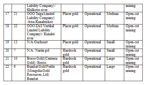
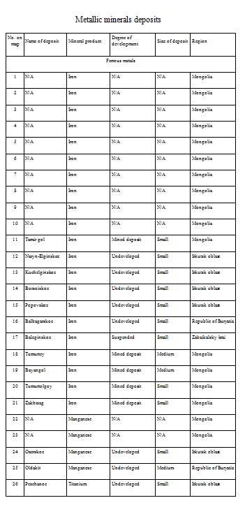
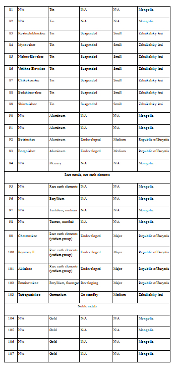
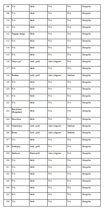
        <rdf:li rdf:resource="http://bic.iwlearn.org/en/atlas/atlas/44-ferrous-nonferrous-rare-and-precious-metal-resources-and-their-extraction-map/ferrous-nonferrous-rare-and-precious-metal-resources-and-their-extraction-map"/>
      
      
        <rdf:li rdf:resource="http://bic.iwlearn.org/en/atlas/atlas/42-landscape-stability-map/landscape-stability-map"/>
      
      
        <rdf:li rdf:resource="http://bic.iwlearn.org/en/atlas/atlas/41-physiographic-regionalization-map/physiographic-regionalization-map"/>
      
    </rdf:Seq>
  </items>

</channel>


  <item rdf:about="http://bic.iwlearn.org/en/atlas/atlas/60-environmental-landscapes-map/environmental-landscapes-map">
    <title>Environmental landscapes  map</title>
    <link>http://bic.iwlearn.org/en/atlas/atlas/60-environmental-landscapes-map/environmental-landscapes-map</link>
    <description></description>
    <content:encoded xmlns:content="http://purl.org/rss/1.0/modules/content/"><![CDATA[<p><img class="image-inline" src="../../../resolveuid/f3ef729f165c401482e6b4eb394f24f1/@@images/image/preview" /></p>
<p><a href="http://bic.iwlearn.org/en/atlas/photos/copy_of__60_Environmentallandscapes.png" class="internal-link">Open full size</a></p>
<p align="center"><b>Environment resources: ecological resources of landscapes in the </b><b>B</b><b>aikal basin</b></p>
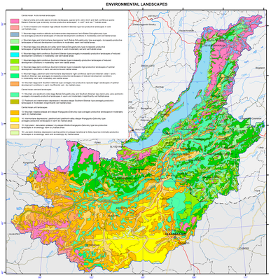
<p>This package contains small-scale overview maps with the most common patterns of ecological resources of landscapes in the Baikal basin. The definition “ecological resource”, which is identical to the definition “ecological potential”, means the ability of landscapes to provide people with all necessary conditions for existence, i.e. to create specific local environment.</p>
<p>The structure of the map package was developed as applicable to the solution of practical problems of information support of regional programmes on rational use and protection of natural landscapes. The information base of the package consists of literature sources [Geosystems …, 1991; Isachenko, 1990; Mikheev, 1987, 1988; Polikarpov et al., 1980; Sochava, 2005], cartographic material [Atlas …, 2004; National Atlas …, 1990; Correlation …, 1977; Landscapes …, 1977; Eco-geographic …, 1996] and Internet resources. <b> </b></p>
<p><b> </b></p>
<p align="center"> </p>
<p align="center"><b>Landscape-ecological complexes</b></p>
<p>This map is a mosaic of 16 structural landscape subdivisions belonging to 2 subcontinents (Northern and Central Asia) and 3 types of natural conditions (arctic-boreal, semiarid and arid) [Geosystems …, 1991].</p>
<p>Typological classification of landscapes (goletz, subgoletz, upper taiga, taiga, subtaiga and steppe) reflects altitude-zonal differentiation of environmental conditions, as well as depression and piedmont effects of their manifestation. Regional range of landscapes classification (Baikal-Dzhugdzhurskiye, South-Siberian, Central Asian, Khangaisko-Daurskiye, Srednekhalkhasko-Mongolian) includes sector differentiation of environmental conditions formed under the influence of prevailing air masses of different direction (mainly western and eastern transfer), as well as interpenetration and uniqueness of natural phenomena in the basin of Lake Baikal.</p>
<p>According to the material and energy exchange, the North-Asian goletz, taiga and subtaiga landscapes are subdivided into subgroups of natural conditions: extreme, reduced, limited and optimal development. South-Siberian and Central Asian steppe landscapes are subdivided into arid, dry and very dry landscapes depending on moisture supply of these landscapes.</p>
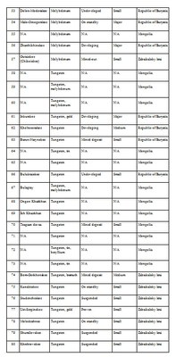
<p>The legend of the map also presents numerical values of integral intensity of landscape functioning (heat and moisture supply of landscapes and plant biological productivity) [Eco-geographic …, 1996]:</p>
<p>- heat supply (total mean daily temperatures over 10ºC): cold (600-800ºC), moderately cold (800-1200 ºC), moderately warm (1200-1600 ºC) and warm (1600-2000 ºC);</p>
<p>- moisture supply (radiation dryness index according to M. Budyko): perhumid (less than 0.5), humid (0.5-0.9),  subhumid (1.0-1.4), insufficiently humid (1.5-1.9), dry (2.0-2.4), and very dry (over 2.5);</p>
<p>- plant biological productivity (annual growth of plants at appropriate values of heat and moisture expressed in dry mass of organic matter of terrestrial and underground parts of plants): very low (less than 20 metric centners/ha), low (20-40 metric centners/ha), mean (40-60 metric centners/ha), elevated (60-80 metric centners/ha), and high (over 80 metric centners/ha).</p>
<p>This map is used as an interpretation basis for the development of derived assessment and recommendation maps of the environment.</p>]]></content:encoded>
    <dc:publisher>No publisher</dc:publisher>
    <dc:creator>Alexander Ayurzhanaev</dc:creator>
    <dc:rights></dc:rights>
    <dc:date>2014-10-09T01:55:00Z</dc:date>
    <dc:type>Page</dc:type>
  </item>


  <item rdf:about="http://bic.iwlearn.org/en/atlas/atlas/59-hunting-resources-map/hunting-resources-map">
    <title>Hunting resources. Wild fowl map</title>
    <link>http://bic.iwlearn.org/en/atlas/atlas/59-hunting-resources-map/hunting-resources-map</link>
    <description></description>
    <content:encoded xmlns:content="http://purl.org/rss/1.0/modules/content/"><![CDATA[<p><img class="image-inline" src="../../../resolveuid/c91994aa9d884df9be1a105391080f51/@@images/image/preview" /></p>
<p><a href="http://bic.iwlearn.org/en/atlas/photos/copy_of__59_Huntingresources.png" class="internal-link">Open full size</a></p>
<p align="center"><strong>Game animals</strong></p>
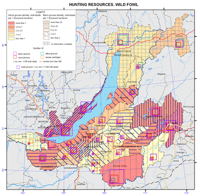
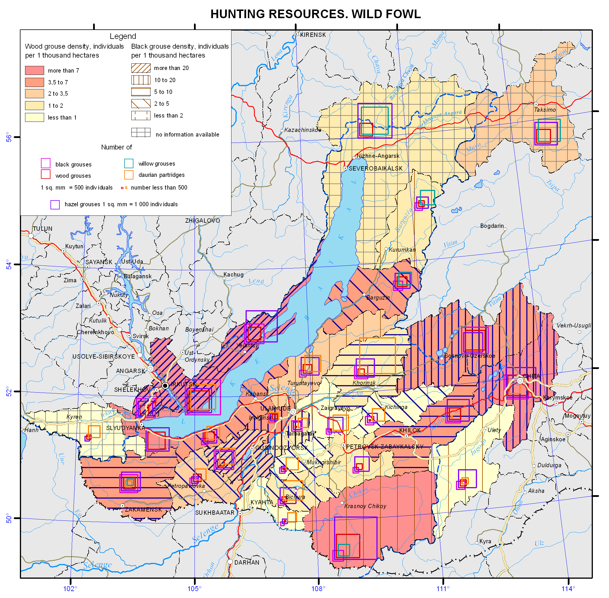
<p>The resource potential of game animals of the Baikal basin has long been characterized by the abundance and high species diversity. This is due to the location of the territory at the intersection of Central-Asian, European-Siberian and East-Asian faunas, where representatives of all of these complexes, including species valuable for hunting, are found. Within the region, there are four typological landscape complexes, corresponding to the zonal and regional landscape subdivisions, namely: mountain-taiga, goletz, forest-steppe, and steppe. Each of them is characterized by a set of habitat types, the quality and quantity of which influence the number of animals.</p>
<p>The wildlife of the <b><i>mountain taiga </i></b>is the richest and most diverse; there manifestations of latitudinal zonality in the distribution of vegetation are complicated by the features of altitudinal zonality of its location in the mountains depending on the steepness and exposure of slopes. This creates prerequisites to spread the spectrum of landscape-ecological diversity of the conditions of animal habitats, and possibilities for most of them to choose the most valuable biotopes and, eventually, to increase in the number. In the mountain taiga squirrel, hazel grouse, sable, bear, and in some places musk deer are numerous. Siberian stag and roe deer inhabiting light slopes, forest openings and woodlots, as well as elk, inhabiting waterlogged intermountain depressions, creek valleys and wide plots of terraces in the coastal area of Lake Baikal, are common. Wolf is numerous in some places; wood grouse and fox are common; lynx and wolverine are less common. Unique populations of reindeer and black-capped marmot survived in high-mountain belts of ridges on both sides of Lake Baikal thanks to the good protection.</p>
<p>Nerpa (Baikal seal) occupies a special place, being the only representative of the family of pinnipeds on Lake Baikal. Its largest rookery is located on the Malye Ushkanyi Islands.</p>
<p>The <b><i>goletz complex</i></b> is characterized by a significantly lower abundance of game animals. Willow and rock ptarmigan, reindeer and ermine belong to permanent residents. This complex can be roughly considered a complementing link to the mountain-taiga one since so many game animals, especially the ungulates, as well as bear, are connected with the highlands by systematic seasonal migrations.</p>
<p>The <b><i>forest-steppe and steppe complexes</i></b> stretch in narrow discontinuous bands in the south of the region. They are represented by the Central-Asian mountain steppes and are not distinguished by the abundance of game animals. Only roe deer in the forest-steppe continues to hold the background position among other species, while tarbagan, once numerous in the steppe, has lost its former significance as a result of plowing of the Transbaikalian steppes and its extermination as a carrier of epizootic plague in the course of antiplague measures. Other species characteristic of the forest-steppe zone, namely, badger and raccoon dog, and of the steppe zone, namely, tolai hare, manul, and dzeren, are small in number. Some of them (dzeren and manul) are protected.</p>
<p>The status of game animals is examined only for the Russian part of the Baikal basin. In connection with the reorganizational measures in the Russian hunting sector over the past two decades, some negative manifestations can be noticed in the usage patterns of species valuable for hunting and in the dynamics of their numbers. A number of problems arose, connected mainly with wild ungulates, especially Siberian stag, roe deer, elk, wild reindeer, and in some places musk deer. Concerning these species ​​an undisputed conclusion was made (as, indeed, for other regions) that “the current dynamics of populations of wild ungulates in Russia is determined mainly by hunters (poachers to a greater extent), large predators, and, locally, snowy winters, and not by a natural cyclicity and changes in the productivity of phytocenoses” [Kozhichev, 2002; Danilkin, 2010].</p>
<p>Among large predators the greatest harm is done by wolves. The wolf problem arose due to the loosening of its control. The damage from this predator to the ungulates (Siberian stag and, especially, roe deer) in different regions of Buryatia reaches 8-30% of the autumn herd [Noskov, 2008]. In recent years, in consequence of the irregular decrease in the number of Siberian stag (poaching and death by predators) in conjunction with the legal shooting in Buryatia a crisis situation with the population of this deer was created [Noskov, 2008]. The damage from wolves only in Transbaikalia in 2011 amounted to11.6 million roubles to agriculture and 70-80 million rubles to hunting [Samoilov, Kayukova, 2013]. Because of the large number of wolves in some areas of Transbaikalia an emergency situation was declared [Samoilov, Kayukova, 2013].</p>
<p>In the current situation, the negative effects are smoothed out to some extent through a network of specially protected natural areas. Thus, in Buryatia, 7-8% of the total number of Siberian stag and roe deer are protected within the territories of 13 nature reserves (zakazniks) and 3 reserved areas (zapovedniks) [Noskov, 2008]. Reindeer is listed in the Red Book of the Republic of Buryatia. Measures to protect the hunting grounds, especially in the areas of concentration of animals, are taken.</p>
<p>Another situation formed with respect to fur-bearing species of hunting. This is due to the fall in world prices for raw fur. Eighteen million pelts of caged mink from China were mass-marketed [Romanov, 2008]. Because of low prices for Chinese mink, squirrel or muskrat fur coats turned out to be more expensive. As a result, squirrel and muskrat are in little demand on the market. The same situation takes place with other species, namely: fox, Siberian weasel, and ermine. Rare lynx and wolverine pelts are used mainly on the domestic market.</p>
<p>A diametrically opposite situation is with sable enabling Russia to achieve a dominant position in the world market as an exclusive supplier of sable fur. Demand and prices for sable pelts have increased. The price for a sable at an auction averages 220-250 dollars. As opposed to the past years, sable is not endangered as there are less professional hunters. Besides, remote hunting lands are not utilized. They have become a kind of sable reserves, where sables multiply and settle throughout the taiga.</p>
<p>The analysis of the status of hunting fauna in the Baikal basin revealed a number of trends in the features of its use, also characteristic of other regions of the country, in particular, the problem of protecting ungulates. A positive phenomenon is a continued status of sable as the leader in the world fur market, and a removal of the danger of its extermination due to changes in socio-economic conditions, which is important in contrast with previous years.</p>
<p>At the same time, unlike the majority of Siberian regions where a trend of rapid increase in the area of publicly available lands accelerated, in the region under consideration this phenomenon is minimized. This is indicative of targeted optimization of the utilization of game animals resources on the basis of improving forms of hunting management and prospects of its development in the region. Thus, the calculations [Dambiev et al., 2011] made it possible to estimate the socio-economic significance of hunting nature management in the Republic of Buryatia in 2010 as amounting to 1.1 billion roubles. Among them natural products of hunting (furs, meat, etc.) are estimated at 150 million roubles, while the social impact of tourism associated with hunting reaches 450 million roubles. The remaining portion is accounted for by other socio-economic relevance. Therefore, the current state of game fauna in the study region is characterized as conditionally stable. As a result of satisfactory organization of protection of game animals in the region, their number corresponds to a primitive stage of market hunting management.<b></b></p>
<p align="center">References</p>
<p>Dambiev, A.G., Kambalin, V.S., and Noskov, V.T. (2011). <i>Hunting nature management of the Republic of Buryatia: problems and prospects.</i> Irkutsk: Izd-vo Irkutskoi  selskokhozyaistvennoi akademii. - 109 p.</p>
<p>Danilkin, A. (2010). <i>Wild ungulates of Russia: patterns of population dynamics, in Okhota i okhotnichie khozyaistvo</i>, no.10, pp. 1-4.</p>
<p>Kozhichev, R. (2002). Siberian roe deer in Irkutsk oblast: what to do? in <i>Okhota i okhotnichie khozyaistvo</i>, , no. 12, pp. 4-5.</p>
<p>Noskov, V.T. (2008). <i>Game animals of Buryatia</i>. Ulan-Ude: Izd-vo FGOU VP. “BGSKhA” im. V.V. Filippova, , 223 p.</p>
<p>Romanov, V.I. (2008). Organizational obstacles for producing hunting fur in Eastern Siberia in Protection and sustainable use of animal and plant resources. <i>Proceedings of the International Scientific Conference, May, 29 – June, 1, 2008</i>. Irkutsk: Izd-vo Irkutskoi selskokhozyaistvennoi akademii, pp. 134-136.</p>
<p>Samoilov, E.B. and Kayukova, S.N. (2013). <i>Invasion of wolves in Transbaikalia</i>.  Irkutsk: Izd-vo IrGSKhA, pp. 261-263.</p>]]></content:encoded>
    <dc:publisher>No publisher</dc:publisher>
    <dc:creator>Alexander Ayurzhanaev</dc:creator>
    <dc:rights></dc:rights>
    <dc:date>2014-10-09T01:55:00Z</dc:date>
    <dc:type>Page</dc:type>
  </item>


  <item rdf:about="http://bic.iwlearn.org/en/atlas/atlas/58-hunting-resources-map/hunting-resources-map">
    <title>Hunting resources. Squirrel and hare map</title>
    <link>http://bic.iwlearn.org/en/atlas/atlas/58-hunting-resources-map/hunting-resources-map</link>
    <description></description>
    <content:encoded xmlns:content="http://purl.org/rss/1.0/modules/content/"><![CDATA[<p><img class="image-inline" src="../../../resolveuid/e2a290cdf91246f7ba5244c4422504fd/@@images/image/preview" /></p>
<p><a href="http://bic.iwlearn.org/en/atlas/photos/copy_of__58_Huntingresources.png" class="internal-link">Open full size</a></p>
<p align="center"><strong>Game animals</strong></p>
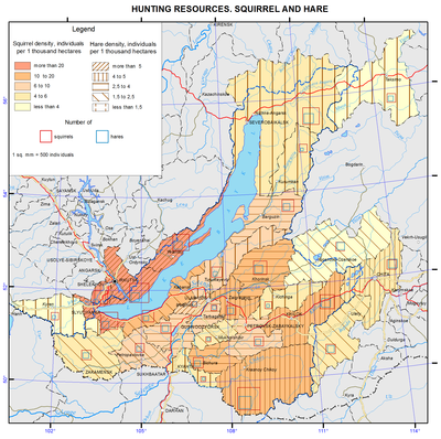
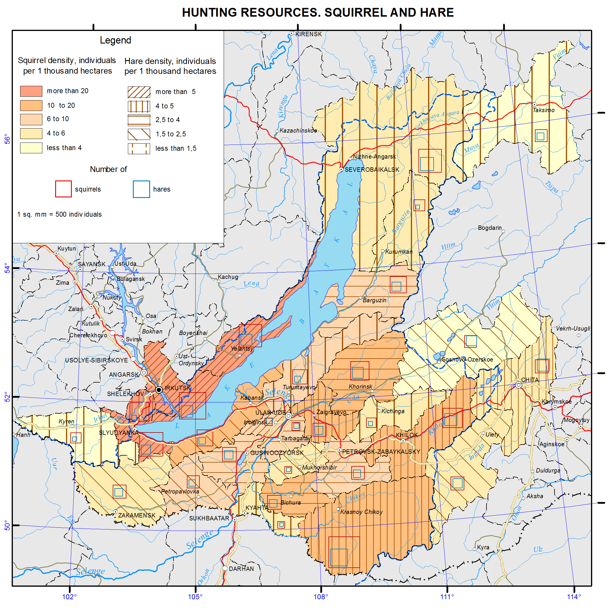
<p>The resource potential of game animals of the Baikal basin has long been characterized by the abundance and high species diversity. This is due to the location of the territory at the intersection of Central-Asian, European-Siberian and East-Asian faunas, where representatives of all of these complexes, including species valuable for hunting, are found. Within the region, there are four typological landscape complexes, corresponding to the zonal and regional landscape subdivisions, namely: mountain-taiga, goletz, forest-steppe, and steppe. Each of them is characterized by a set of habitat types, the quality and quantity of which influence the number of animals.</p>
<p>The wildlife of the <b><i>mountain taiga </i></b>is the richest and most diverse; there manifestations of latitudinal zonality in the distribution of vegetation are complicated by the features of altitudinal zonality of its location in the mountains depending on the steepness and exposure of slopes. This creates prerequisites to spread the spectrum of landscape-ecological diversity of the conditions of animal habitats, and possibilities for most of them to choose the most valuable biotopes and, eventually, to increase in the number. In the mountain taiga squirrel, hazel grouse, sable, bear, and in some places musk deer are numerous. Siberian stag and roe deer inhabiting light slopes, forest openings and woodlots, as well as elk, inhabiting waterlogged intermountain depressions, creek valleys and wide plots of terraces in the coastal area of Lake Baikal, are common. Wolf is numerous in some places; wood grouse and fox are common; lynx and wolverine are less common. Unique populations of reindeer and black-capped marmot survived in high-mountain belts of ridges on both sides of Lake Baikal thanks to the good protection.</p>
<p>Nerpa (Baikal seal) occupies a special place, being the only representative of the family of pinnipeds on Lake Baikal. Its largest rookery is located on the Malye Ushkanyi Islands.</p>
<p>The <b><i>goletz complex</i></b> is characterized by a significantly lower abundance of game animals. Willow and rock ptarmigan, reindeer and ermine belong to permanent residents. This complex can be roughly considered a complementing link to the mountain-taiga one since so many game animals, especially the ungulates, as well as bear, are connected with the highlands by systematic seasonal migrations.</p>
<p>The <b><i>forest-steppe and steppe complexes</i></b> stretch in narrow discontinuous bands in the south of the region. They are represented by the Central-Asian mountain steppes and are not distinguished by the abundance of game animals. Only roe deer in the forest-steppe continues to hold the background position among other species, while tarbagan, once numerous in the steppe, has lost its former significance as a result of plowing of the Transbaikalian steppes and its extermination as a carrier of epizootic plague in the course of antiplague measures. Other species characteristic of the forest-steppe zone, namely, badger and raccoon dog, and of the steppe zone, namely, tolai hare, manul, and dzeren, are small in number. Some of them (dzeren and manul) are protected.</p>
<p>The status of game animals is examined only for the Russian part of the Baikal basin. In connection with the reorganizational measures in the Russian hunting sector over the past two decades, some negative manifestations can be noticed in the usage patterns of species valuable for hunting and in the dynamics of their numbers. A number of problems arose, connected mainly with wild ungulates, especially Siberian stag, roe deer, elk, wild reindeer, and in some places musk deer. Concerning these species ​​an undisputed conclusion was made (as, indeed, for other regions) that “the current dynamics of populations of wild ungulates in Russia is determined mainly by hunters (poachers to a greater extent), large predators, and, locally, snowy winters, and not by a natural cyclicity and changes in the productivity of phytocenoses” [Kozhichev, 2002; Danilkin, 2010].</p>
<p>Among large predators the greatest harm is done by wolves. The wolf problem arose due to the loosening of its control. The damage from this predator to the ungulates (Siberian stag and, especially, roe deer) in different regions of Buryatia reaches 8-30% of the autumn herd [Noskov, 2008]. In recent years, in consequence of the irregular decrease in the number of Siberian stag (poaching and death by predators) in conjunction with the legal shooting in Buryatia a crisis situation with the population of this deer was created [Noskov, 2008]. The damage from wolves only in Transbaikalia in 2011 amounted to11.6 million roubles to agriculture and 70-80 million rubles to hunting [Samoilov, Kayukova, 2013]. Because of the large number of wolves in some areas of Transbaikalia an emergency situation was declared [Samoilov, Kayukova, 2013].</p>
<p>In the current situation, the negative effects are smoothed out to some extent through a network of specially protected natural areas. Thus, in Buryatia, 7-8% of the total number of Siberian stag and roe deer are protected within the territories of 13 nature reserves (zakazniks) and 3 reserved areas (zapovedniks) [Noskov, 2008]. Reindeer is listed in the Red Book of the Republic of Buryatia. Measures to protect the hunting grounds, especially in the areas of concentration of animals, are taken.</p>
<p>Another situation formed with respect to fur-bearing species of hunting. This is due to the fall in world prices for raw fur. Eighteen million pelts of caged mink from China were mass-marketed [Romanov, 2008]. Because of low prices for Chinese mink, squirrel or muskrat fur coats turned out to be more expensive. As a result, squirrel and muskrat are in little demand on the market. The same situation takes place with other species, namely: fox, Siberian weasel, and ermine. Rare lynx and wolverine pelts are used mainly on the domestic market.</p>
<p>A diametrically opposite situation is with sable enabling Russia to achieve a dominant position in the world market as an exclusive supplier of sable fur. Demand and prices for sable pelts have increased. The price for a sable at an auction averages 220-250 dollars. As opposed to the past years, sable is not endangered as there are less professional hunters. Besides, remote hunting lands are not utilized. They have become a kind of sable reserves, where sables multiply and settle throughout the taiga.</p>
<p>The analysis of the status of hunting fauna in the Baikal basin revealed a number of trends in the features of its use, also characteristic of other regions of the country, in particular, the problem of protecting ungulates. A positive phenomenon is a continued status of sable as the leader in the world fur market, and a removal of the danger of its extermination due to changes in socio-economic conditions, which is important in contrast with previous years.</p>
<p>At the same time, unlike the majority of Siberian regions where a trend of rapid increase in the area of publicly available lands accelerated, in the region under consideration this phenomenon is minimized. This is indicative of targeted optimization of the utilization of game animals resources on the basis of improving forms of hunting management and prospects of its development in the region. Thus, the calculations [Dambiev et al., 2011] made it possible to estimate the socio-economic significance of hunting nature management in the Republic of Buryatia in 2010 as amounting to 1.1 billion roubles. Among them natural products of hunting (furs, meat, etc.) are estimated at 150 million roubles, while the social impact of tourism associated with hunting reaches 450 million roubles. The remaining portion is accounted for by other socio-economic relevance. Therefore, the current state of game fauna in the study region is characterized as conditionally stable. As a result of satisfactory organization of protection of game animals in the region, their number corresponds to a primitive stage of market hunting management.<b></b></p>
<p align="center">References</p>
<p>Dambiev, A.G., Kambalin, V.S., and Noskov, V.T. (2011). <i>Hunting nature management of the Republic of Buryatia: problems and prospects.</i> Irkutsk: Izd-vo Irkutskoi  selskokhozyaistvennoi akademii. - 109 p.</p>
<p>Danilkin, A. (2010). <i>Wild ungulates of Russia: patterns of population dynamics, in Okhota i okhotnichie khozyaistvo</i>, no.10, pp. 1-4.</p>
<p>Kozhichev, R. (2002). Siberian roe deer in Irkutsk oblast: what to do? in <i>Okhota i okhotnichie khozyaistvo</i>, , no. 12, pp. 4-5.</p>
<p>Noskov, V.T. (2008). <i>Game animals of Buryatia</i>. Ulan-Ude: Izd-vo FGOU VP. “BGSKhA” im. V.V. Filippova, , 223 p.</p>
<p>Romanov, V.I. (2008). Organizational obstacles for producing hunting fur in Eastern Siberia in Protection and sustainable use of animal and plant resources. <i>Proceedings of the International Scientific Conference, May, 29 – June, 1, 2008</i>. Irkutsk: Izd-vo Irkutskoi selskokhozyaistvennoi akademii, pp. 134-136.</p>
<p>Samoilov, E.B. and Kayukova, S.N. (2013). <i>Invasion of wolves in Transbaikalia</i>.  Irkutsk: Izd-vo IrGSKhA, pp. 261-263.</p>]]></content:encoded>
    <dc:publisher>No publisher</dc:publisher>
    <dc:creator>Alexander Ayurzhanaev</dc:creator>
    <dc:rights></dc:rights>
    <dc:date>2014-10-09T01:45:00Z</dc:date>
    <dc:type>Page</dc:type>
  </item>


  <item rdf:about="http://bic.iwlearn.org/en/atlas/atlas/57-hunting-resources-map/hunting-resources-map">
    <title>Hunting resources. Fur-bearing animals map</title>
    <link>http://bic.iwlearn.org/en/atlas/atlas/57-hunting-resources-map/hunting-resources-map</link>
    <description></description>
    <content:encoded xmlns:content="http://purl.org/rss/1.0/modules/content/"><![CDATA[<p><img class="image-inline" src="../../../resolveuid/cda03ffdcb44441cb11554ce5d32cbfd/@@images/image/preview" /></p>
<p>Open full size</p>
<p align="center"><strong>Game animals</strong></p>
<p>The resource potential of game animals of the Baikal basin has long been characterized by the abundance and high species diversity. This is due to the location of the territory at the intersection of Central-Asian, European-Siberian and East-Asian faunas, where representatives of all of these complexes, including species valuable for hunting, are found. Within the region, there are four typological landscape complexes, corresponding to the zonal and regional landscape subdivisions, namely: mountain-taiga, goletz, forest-steppe, and steppe. Each of them is characterized by a set of habitat types, the quality and quantity of which influence the number of animals.</p>
<p>The wildlife of the <b><i>mountain taiga </i></b>is the richest and most diverse; there manifestations of latitudinal zonality in the distribution of vegetation are complicated by the features of altitudinal zonality of its location in the mountains depending on the steepness and exposure of slopes. This creates prerequisites to spread the spectrum of landscape-ecological diversity of the conditions of animal habitats, and possibilities for most of them to choose the most valuable biotopes and, eventually, to increase in the number. In the mountain taiga squirrel, hazel grouse, sable, bear, and in some places musk deer are numerous. Siberian stag and roe deer inhabiting light slopes, forest openings and woodlots, as well as elk, inhabiting waterlogged intermountain depressions, creek valleys and wide plots of terraces in the coastal area of Lake Baikal, are common. Wolf is numerous in some places; wood grouse and fox are common; lynx and wolverine are less common. Unique populations of reindeer and black-capped marmot survived in high-mountain belts of ridges on both sides of Lake Baikal thanks to the good protection.</p>
<p>Nerpa (Baikal seal) occupies a special place, being the only representative of the family of pinnipeds on Lake Baikal. Its largest rookery is located on the Malye Ushkanyi Islands.</p>
<p>The <b><i>goletz complex</i></b> is characterized by a significantly lower abundance of game animals. Willow and rock ptarmigan, reindeer and ermine belong to permanent residents. This complex can be roughly considered a complementing link to the mountain-taiga one since so many game animals, especially the ungulates, as well as bear, are connected with the highlands by systematic seasonal migrations.</p>
<p>The <b><i>forest-steppe and steppe complexes</i></b> stretch in narrow discontinuous bands in the south of the region. They are represented by the Central-Asian mountain steppes and are not distinguished by the abundance of game animals. Only roe deer in the forest-steppe continues to hold the background position among other species, while tarbagan, once numerous in the steppe, has lost its former significance as a result of plowing of the Transbaikalian steppes and its extermination as a carrier of epizootic plague in the course of antiplague measures. Other species characteristic of the forest-steppe zone, namely, badger and raccoon dog, and of the steppe zone, namely, tolai hare, manul, and dzeren, are small in number. Some of them (dzeren and manul) are protected.</p>
<p>The status of game animals is examined only for the Russian part of the Baikal basin. In connection with the reorganizational measures in the Russian hunting sector over the past two decades, some negative manifestations can be noticed in the usage patterns of species valuable for hunting and in the dynamics of their numbers. A number of problems arose, connected mainly with wild ungulates, especially Siberian stag, roe deer, elk, wild reindeer, and in some places musk deer. Concerning these species ​​an undisputed conclusion was made (as, indeed, for other regions) that “the current dynamics of populations of wild ungulates in Russia is determined mainly by hunters (poachers to a greater extent), large predators, and, locally, snowy winters, and not by a natural cyclicity and changes in the productivity of phytocenoses” [Kozhichev, 2002; Danilkin, 2010].</p>
<p>Among large predators the greatest harm is done by wolves. The wolf problem arose due to the loosening of its control. The damage from this predator to the ungulates (Siberian stag and, especially, roe deer) in different regions of Buryatia reaches 8-30% of the autumn herd [Noskov, 2008]. In recent years, in consequence of the irregular decrease in the number of Siberian stag (poaching and death by predators) in conjunction with the legal shooting in Buryatia a crisis situation with the population of this deer was created [Noskov, 2008]. The damage from wolves only in Transbaikalia in 2011 amounted to11.6 million roubles to agriculture and 70-80 million rubles to hunting [Samoilov, Kayukova, 2013]. Because of the large number of wolves in some areas of Transbaikalia an emergency situation was declared [Samoilov, Kayukova, 2013].</p>
<p>In the current situation, the negative effects are smoothed out to some extent through a network of specially protected natural areas. Thus, in Buryatia, 7-8% of the total number of Siberian stag and roe deer are protected within the territories of 13 nature reserves (zakazniks) and 3 reserved areas (zapovedniks) [Noskov, 2008]. Reindeer is listed in the Red Book of the Republic of Buryatia. Measures to protect the hunting grounds, especially in the areas of concentration of animals, are taken.</p>
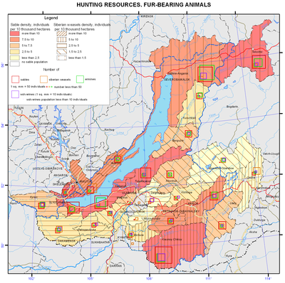
<p>Another situation formed with respect to fur-bearing species of hunting. This is due to the fall in world prices for raw fur. Eighteen million pelts of caged mink from China were mass-marketed [Romanov, 2008]. Because of low prices for Chinese mink, squirrel or muskrat fur coats turned out to be more expensive. As a result, squirrel and muskrat are in little demand on the market. The same situation takes place with other species, namely: fox, Siberian weasel, and ermine. Rare lynx and wolverine pelts are used mainly on the domestic market.</p>
<p>A diametrically opposite situation is with sable enabling Russia to achieve a dominant position in the world market as an exclusive supplier of sable fur. Demand and prices for sable pelts have increased. The price for a sable at an auction averages 220-250 dollars. As opposed to the past years, sable is not endangered as there are less professional hunters. Besides, remote hunting lands are not utilized. They have become a kind of sable reserves, where sables multiply and settle throughout the taiga.</p>
<p>The analysis of the status of hunting fauna in the Baikal basin revealed a number of trends in the features of its use, also characteristic of other regions of the country, in particular, the problem of protecting ungulates. A positive phenomenon is a continued status of sable as the leader in the world fur market, and a removal of the danger of its extermination due to changes in socio-economic conditions, which is important in contrast with previous years.</p>
<p>At the same time, unlike the majority of Siberian regions where a trend of rapid increase in the area of publicly available lands accelerated, in the region under consideration this phenomenon is minimized. This is indicative of targeted optimization of the utilization of game animals resources on the basis of improving forms of hunting management and prospects of its development in the region. Thus, the calculations [Dambiev et al., 2011] made it possible to estimate the socio-economic significance of hunting nature management in the Republic of Buryatia in 2010 as amounting to 1.1 billion roubles. Among them natural products of hunting (furs, meat, etc.) are estimated at 150 million roubles, while the social impact of tourism associated with hunting reaches 450 million roubles. The remaining portion is accounted for by other socio-economic relevance. Therefore, the current state of game fauna in the study region is characterized as conditionally stable. As a result of satisfactory organization of protection of game animals in the region, their number corresponds to a primitive stage of market hunting management.<b></b></p>
<p align="center">References</p>
<p>Dambiev, A.G., Kambalin, V.S., and Noskov, V.T. (2011). <i>Hunting nature management of the Republic of Buryatia: problems and prospects.</i> Irkutsk: Izd-vo Irkutskoi  selskokhozyaistvennoi akademii. - 109 p.</p>
<p>Danilkin, A. (2010). <i>Wild ungulates of Russia: patterns of population dynamics, in Okhota i okhotnichie khozyaistvo</i>, no.10, pp. 1-4.</p>
<p>Kozhichev, R. (2002). Siberian roe deer in Irkutsk oblast: what to do? in <i>Okhota i okhotnichie khozyaistvo</i>, , no. 12, pp. 4-5.</p>
<p>Noskov, V.T. (2008). <i>Game animals of Buryatia</i>. Ulan-Ude: Izd-vo FGOU VP. “BGSKhA” im. V.V. Filippova, , 223 p.</p>
<p>Romanov, V.I. (2008). Organizational obstacles for producing hunting fur in Eastern Siberia in Protection and sustainable use of animal and plant resources. <i>Proceedings of the International Scientific Conference, May, 29 – June, 1, 2008</i>. Irkutsk: Izd-vo Irkutskoi selskokhozyaistvennoi akademii, pp. 134-136.</p>
<p>Samoilov, E.B. and Kayukova, S.N. (2013). <i>Invasion of wolves in Transbaikalia</i>.  Irkutsk: Izd-vo IrGSKhA, pp. 261-263.</p>]]></content:encoded>
    <dc:publisher>No publisher</dc:publisher>
    <dc:creator>Alexander Ayurzhanaev</dc:creator>
    <dc:rights></dc:rights>
    <dc:date>2014-10-09T01:25:00Z</dc:date>
    <dc:type>Page</dc:type>
  </item>


  <item rdf:about="http://bic.iwlearn.org/en/atlas/atlas/56-hunting-resources-map/hunting-resources-map">
    <title>Hunting resources. Predators map</title>
    <link>http://bic.iwlearn.org/en/atlas/atlas/56-hunting-resources-map/hunting-resources-map</link>
    <description></description>
    <content:encoded xmlns:content="http://purl.org/rss/1.0/modules/content/"><![CDATA[<p><img class="image-inline" src="../../../resolveuid/6bc109a885774ac2aeb1d93c94b5b4ba/@@images/image/preview" /></p>
<p><a href="http://bic.iwlearn.org/en/atlas/photos/copy_of__56_Huntingresources.png" class="internal-link">Open full size</a></p>
<p align="center"><strong>Game animals</strong></p>
<p>The resource potential of game animals of the Baikal basin has long been characterized by the abundance and high species diversity. This is due to the location of the territory at the intersection of Central-Asian, European-Siberian and East-Asian faunas, where representatives of all of these complexes, including species valuable for hunting, are found. Within the region, there are four typological landscape complexes, corresponding to the zonal and regional landscape subdivisions, namely: mountain-taiga, goletz, forest-steppe, and steppe. Each of them is characterized by a set of habitat types, the quality and quantity of which influence the number of animals.</p>
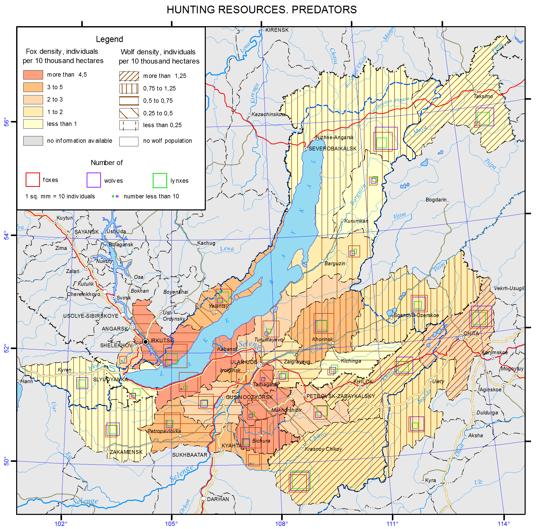
<p>The wildlife of the <b><i>mountain taiga </i></b>is the richest and most diverse; there manifestations of latitudinal zonality in the distribution of vegetation are complicated by the features of altitudinal zonality of its location in the mountains depending on the steepness and exposure of slopes. This creates prerequisites to spread the spectrum of landscape-ecological diversity of the conditions of animal habitats, and possibilities for most of them to choose the most valuable biotopes and, eventually, to increase in the number. In the mountain taiga squirrel, hazel grouse, sable, bear, and in some places musk deer are numerous. Siberian stag and roe deer inhabiting light slopes, forest openings and woodlots, as well as elk, inhabiting waterlogged intermountain depressions, creek valleys and wide plots of terraces in the coastal area of Lake Baikal, are common. Wolf is numerous in some places; wood grouse and fox are common; lynx and wolverine are less common. Unique populations of reindeer and black-capped marmot survived in high-mountain belts of ridges on both sides of Lake Baikal thanks to the good protection.</p>
<p>Nerpa (Baikal seal) occupies a special place, being the only representative of the family of pinnipeds on Lake Baikal. Its largest rookery is located on the Malye Ushkanyi Islands.</p>
<p>The <b><i>goletz complex</i></b> is characterized by a significantly lower abundance of game animals. Willow and rock ptarmigan, reindeer and ermine belong to permanent residents. This complex can be roughly considered a complementing link to the mountain-taiga one since so many game animals, especially the ungulates, as well as bear, are connected with the highlands by systematic seasonal migrations.</p>
<p>The <b><i>forest-steppe and steppe complexes</i></b> stretch in narrow discontinuous bands in the south of the region. They are represented by the Central-Asian mountain steppes and are not distinguished by the abundance of game animals. Only roe deer in the forest-steppe continues to hold the background position among other species, while tarbagan, once numerous in the steppe, has lost its former significance as a result of plowing of the Transbaikalian steppes and its extermination as a carrier of epizootic plague in the course of antiplague measures. Other species characteristic of the forest-steppe zone, namely, badger and raccoon dog, and of the steppe zone, namely, tolai hare, manul, and dzeren, are small in number. Some of them (dzeren and manul) are protected.</p>
<p>The status of game animals is examined only for the Russian part of the Baikal basin. In connection with the reorganizational measures in the Russian hunting sector over the past two decades, some negative manifestations can be noticed in the usage patterns of species valuable for hunting and in the dynamics of their numbers. A number of problems arose, connected mainly with wild ungulates, especially Siberian stag, roe deer, elk, wild reindeer, and in some places musk deer. Concerning these species ​​an undisputed conclusion was made (as, indeed, for other regions) that “the current dynamics of populations of wild ungulates in Russia is determined mainly by hunters (poachers to a greater extent), large predators, and, locally, snowy winters, and not by a natural cyclicity and changes in the productivity of phytocenoses” [Kozhichev, 2002; Danilkin, 2010].</p>
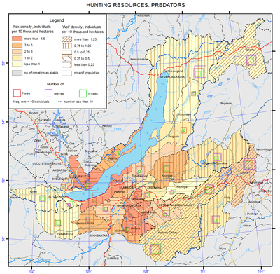
<p>Among large predators the greatest harm is done by wolves. The wolf problem arose due to the loosening of its control. The damage from this predator to the ungulates (Siberian stag and, especially, roe deer) in different regions of Buryatia reaches 8-30% of the autumn herd [Noskov, 2008]. In recent years, in consequence of the irregular decrease in the number of Siberian stag (poaching and death by predators) in conjunction with the legal shooting in Buryatia a crisis situation with the population of this deer was created [Noskov, 2008]. The damage from wolves only in Transbaikalia in 2011 amounted to11.6 million roubles to agriculture and 70-80 million rubles to hunting [Samoilov, Kayukova, 2013]. Because of the large number of wolves in some areas of Transbaikalia an emergency situation was declared [Samoilov, Kayukova, 2013].</p>
<p>In the current situation, the negative effects are smoothed out to some extent through a network of specially protected natural areas. Thus, in Buryatia, 7-8% of the total number of Siberian stag and roe deer are protected within the territories of 13 nature reserves (zakazniks) and 3 reserved areas (zapovedniks) [Noskov, 2008]. Reindeer is listed in the Red Book of the Republic of Buryatia. Measures to protect the hunting grounds, especially in the areas of concentration of animals, are taken.</p>
<p>Another situation formed with respect to fur-bearing species of hunting. This is due to the fall in world prices for raw fur. Eighteen million pelts of caged mink from China were mass-marketed [Romanov, 2008]. Because of low prices for Chinese mink, squirrel or muskrat fur coats turned out to be more expensive. As a result, squirrel and muskrat are in little demand on the market. The same situation takes place with other species, namely: fox, Siberian weasel, and ermine. Rare lynx and wolverine pelts are used mainly on the domestic market.</p>
<p>A diametrically opposite situation is with sable enabling Russia to achieve a dominant position in the world market as an exclusive supplier of sable fur. Demand and prices for sable pelts have increased. The price for a sable at an auction averages 220-250 dollars. As opposed to the past years, sable is not endangered as there are less professional hunters. Besides, remote hunting lands are not utilized. They have become a kind of sable reserves, where sables multiply and settle throughout the taiga.</p>
<p>The analysis of the status of hunting fauna in the Baikal basin revealed a number of trends in the features of its use, also characteristic of other regions of the country, in particular, the problem of protecting ungulates. A positive phenomenon is a continued status of sable as the leader in the world fur market, and a removal of the danger of its extermination due to changes in socio-economic conditions, which is important in contrast with previous years.</p>
<p>At the same time, unlike the majority of Siberian regions where a trend of rapid increase in the area of publicly available lands accelerated, in the region under consideration this phenomenon is minimized. This is indicative of targeted optimization of the utilization of game animals resources on the basis of improving forms of hunting management and prospects of its development in the region. Thus, the calculations [Dambiev et al., 2011] made it possible to estimate the socio-economic significance of hunting nature management in the Republic of Buryatia in 2010 as amounting to 1.1 billion roubles. Among them natural products of hunting (furs, meat, etc.) are estimated at 150 million roubles, while the social impact of tourism associated with hunting reaches 450 million roubles. The remaining portion is accounted for by other socio-economic relevance. Therefore, the current state of game fauna in the study region is characterized as conditionally stable. As a result of satisfactory organization of protection of game animals in the region, their number corresponds to a primitive stage of market hunting management.<b></b></p>
<p align="center">References</p>
<p>Dambiev, A.G., Kambalin, V.S., and Noskov, V.T. (2011). <i>Hunting nature management of the Republic of Buryatia: problems and prospects.</i> Irkutsk: Izd-vo Irkutskoi  selskokhozyaistvennoi akademii. - 109 p.</p>
<p>Danilkin, A. (2010). <i>Wild ungulates of Russia: patterns of population dynamics, in Okhota i okhotnichie khozyaistvo</i>, no.10, pp. 1-4.</p>
<p>Kozhichev, R. (2002). Siberian roe deer in Irkutsk oblast: what to do? in <i>Okhota i okhotnichie khozyaistvo</i>, , no. 12, pp. 4-5.</p>
<p>Noskov, V.T. (2008). <i>Game animals of Buryatia</i>. Ulan-Ude: Izd-vo FGOU VP. “BGSKhA” im. V.V. Filippova, , 223 p.</p>
<p>Romanov, V.I. (2008). Organizational obstacles for producing hunting fur in Eastern Siberia in Protection and sustainable use of animal and plant resources. <i>Proceedings of the International Scientific Conference, May, 29 – June, 1, 2008</i>. Irkutsk: Izd-vo Irkutskoi selskokhozyaistvennoi akademii, pp. 134-136.</p>
<p>Samoilov, E.B. and Kayukova, S.N. (2013). <i>Invasion of wolves in Transbaikalia</i>.  Irkutsk: Izd-vo IrGSKhA, pp. 261-263.</p>]]></content:encoded>
    <dc:publisher>No publisher</dc:publisher>
    <dc:creator>Alexander Ayurzhanaev</dc:creator>
    <dc:rights></dc:rights>
    <dc:date>2014-10-09T00:55:00Z</dc:date>
    <dc:type>Page</dc:type>
  </item>


  <item rdf:about="http://bic.iwlearn.org/en/atlas/atlas/55-hunting-resources-map/hunting-resources-map">
    <title>Hunting resources. Ungulates map</title>
    <link>http://bic.iwlearn.org/en/atlas/atlas/55-hunting-resources-map/hunting-resources-map</link>
    <description></description>
    <content:encoded xmlns:content="http://purl.org/rss/1.0/modules/content/"><![CDATA[<p><img class="image-inline" src="../../../resolveuid/fdccdfaa5cb54a23bcd184d7e2c3ba88/@@images/image/preview" /></p>
<p><a href="http://bic.iwlearn.org/en/atlas/photos/copy_of__55_Huntingresources.png" class="internal-link">Open full size</a></p>
<p align="center"><strong>Game animals</strong></p>
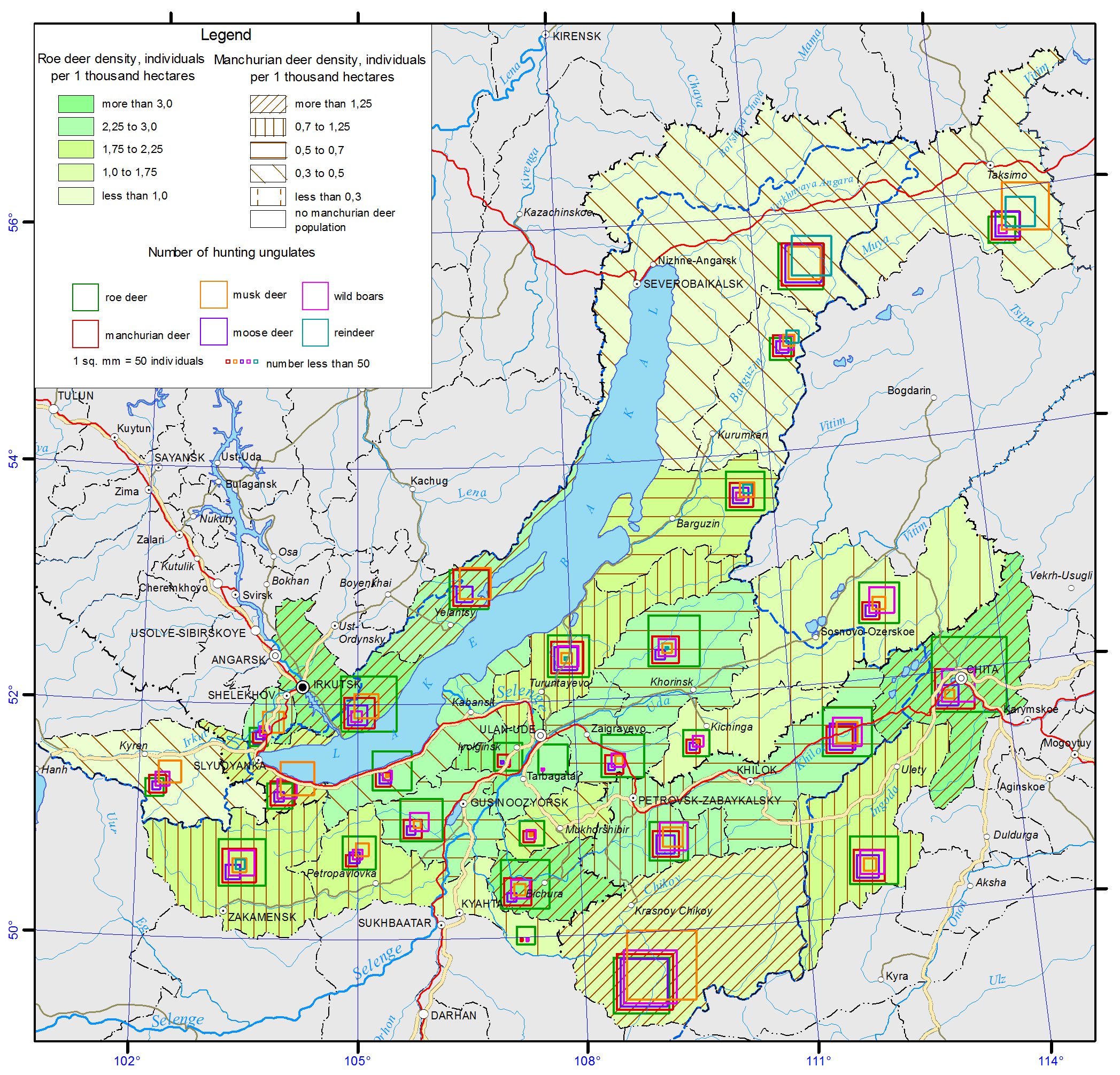
<p>The resource potential of game animals of the Baikal basin has long been characterized by the abundance and high species diversity. This is due to the location of the territory at the intersection of Central-Asian, European-Siberian and East-Asian faunas, where representatives of all of these complexes, including species valuable for hunting, are found. Within the region, there are four typological landscape complexes, corresponding to the zonal and regional landscape subdivisions, namely: mountain-taiga, goletz, forest-steppe, and steppe. Each of them is characterized by a set of habitat types, the quality and quantity of which influence the number of animals.</p>
<p>The wildlife of the <b><i>mountain taiga </i></b>is the richest and most diverse; there manifestations of latitudinal zonality in the distribution of vegetation are complicated by the features of altitudinal zonality of its location in the mountains depending on the steepness and exposure of slopes. This creates prerequisites to spread the spectrum of landscape-ecological diversity of the conditions of animal habitats, and possibilities for most of them to choose the most valuable biotopes and, eventually, to increase in the number. In the mountain taiga squirrel, hazel grouse, sable, bear, and in some places musk deer are numerous. Siberian stag and roe deer inhabiting light slopes, forest openings and woodlots, as well as elk, inhabiting waterlogged intermountain depressions, creek valleys and wide plots of terraces in the coastal area of Lake Baikal, are common. Wolf is numerous in some places; wood grouse and fox are common; lynx and wolverine are less common. Unique populations of reindeer and black-capped marmot survived in high-mountain belts of ridges on both sides of Lake Baikal thanks to the good protection.</p>
<p>Nerpa (Baikal seal) occupies a special place, being the only representative of the family of pinnipeds on Lake Baikal. Its largest rookery is located on the Malye Ushkanyi Islands.</p>
<p>The <b><i>goletz complex</i></b> is characterized by a significantly lower abundance of game animals. Willow and rock ptarmigan, reindeer and ermine belong to permanent residents. This complex can be roughly considered a complementing link to the mountain-taiga one since so many game animals, especially the ungulates, as well as bear, are connected with the highlands by systematic seasonal migrations.</p>
<p>The <b><i>forest-steppe and steppe complexes</i></b> stretch in narrow discontinuous bands in the south of the region. They are represented by the Central-Asian mountain steppes and are not distinguished by the abundance of game animals. Only roe deer in the forest-steppe continues to hold the background position among other species, while tarbagan, once numerous in the steppe, has lost its former significance as a result of plowing of the Transbaikalian steppes and its extermination as a carrier of epizootic plague in the course of antiplague measures. Other species characteristic of the forest-steppe zone, namely, badger and raccoon dog, and of the steppe zone, namely, tolai hare, manul, and dzeren, are small in number. Some of them (dzeren and manul) are protected.</p>
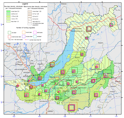
<p>The status of game animals is examined only for the Russian part of the Baikal basin. In connection with the reorganizational measures in the Russian hunting sector over the past two decades, some negative manifestations can be noticed in the usage patterns of species valuable for hunting and in the dynamics of their numbers. A number of problems arose, connected mainly with wild ungulates, especially Siberian stag, roe deer, elk, wild reindeer, and in some places musk deer. Concerning these species ​​an undisputed conclusion was made (as, indeed, for other regions) that “the current dynamics of populations of wild ungulates in Russia is determined mainly by hunters (poachers to a greater extent), large predators, and, locally, snowy winters, and not by a natural cyclicity and changes in the productivity of phytocenoses” [Kozhichev, 2002; Danilkin, 2010].</p>
<p>Among large predators the greatest harm is done by wolves. The wolf problem arose due to the loosening of its control. The damage from this predator to the ungulates (Siberian stag and, especially, roe deer) in different regions of Buryatia reaches 8-30% of the autumn herd [Noskov, 2008]. In recent years, in consequence of the irregular decrease in the number of Siberian stag (poaching and death by predators) in conjunction with the legal shooting in Buryatia a crisis situation with the population of this deer was created [Noskov, 2008]. The damage from wolves only in Transbaikalia in 2011 amounted to11.6 million roubles to agriculture and 70-80 million rubles to hunting [Samoilov, Kayukova, 2013]. Because of the large number of wolves in some areas of Transbaikalia an emergency situation was declared [Samoilov, Kayukova, 2013].</p>
<p>In the current situation, the negative effects are smoothed out to some extent through a network of specially protected natural areas. Thus, in Buryatia, 7-8% of the total number of Siberian stag and roe deer are protected within the territories of 13 nature reserves (zakazniks) and 3 reserved areas (zapovedniks) [Noskov, 2008]. Reindeer is listed in the Red Book of the Republic of Buryatia. Measures to protect the hunting grounds, especially in the areas of concentration of animals, are taken.</p>
<p>Another situation formed with respect to fur-bearing species of hunting. This is due to the fall in world prices for raw fur. Eighteen million pelts of caged mink from China were mass-marketed [Romanov, 2008]. Because of low prices for Chinese mink, squirrel or muskrat fur coats turned out to be more expensive. As a result, squirrel and muskrat are in little demand on the market. The same situation takes place with other species, namely: fox, Siberian weasel, and ermine. Rare lynx and wolverine pelts are used mainly on the domestic market.</p>
<p>A diametrically opposite situation is with sable enabling Russia to achieve a dominant position in the world market as an exclusive supplier of sable fur. Demand and prices for sable pelts have increased. The price for a sable at an auction averages 220-250 dollars. As opposed to the past years, sable is not endangered as there are less professional hunters. Besides, remote hunting lands are not utilized. They have become a kind of sable reserves, where sables multiply and settle throughout the taiga.</p>
<p>The analysis of the status of hunting fauna in the Baikal basin revealed a number of trends in the features of its use, also characteristic of other regions of the country, in particular, the problem of protecting ungulates. A positive phenomenon is a continued status of sable as the leader in the world fur market, and a removal of the danger of its extermination due to changes in socio-economic conditions, which is important in contrast with previous years.</p>
<p>At the same time, unlike the majority of Siberian regions where a trend of rapid increase in the area of publicly available lands accelerated, in the region under consideration this phenomenon is minimized. This is indicative of targeted optimization of the utilization of game animals resources on the basis of improving forms of hunting management and prospects of its development in the region. Thus, the calculations [Dambiev et al., 2011] made it possible to estimate the socio-economic significance of hunting nature management in the Republic of Buryatia in 2010 as amounting to 1.1 billion roubles. Among them natural products of hunting (furs, meat, etc.) are estimated at 150 million roubles, while the social impact of tourism associated with hunting reaches 450 million roubles. The remaining portion is accounted for by other socio-economic relevance. Therefore, the current state of game fauna in the study region is characterized as conditionally stable. As a result of satisfactory organization of protection of game animals in the region, their number corresponds to a primitive stage of market hunting management.<b></b></p>
<p align="center">References</p>
<p>Dambiev, A.G., Kambalin, V.S., and Noskov, V.T. (2011). <i>Hunting nature management of the Republic of Buryatia: problems and prospects.</i> Irkutsk: Izd-vo Irkutskoi  selskokhozyaistvennoi akademii. - 109 p.</p>
<p>Danilkin, A. (2010). <i>Wild ungulates of Russia: patterns of population dynamics, in Okhota i okhotnichie khozyaistvo</i>, no.10, pp. 1-4.</p>
<p>Kozhichev, R. (2002). Siberian roe deer in Irkutsk oblast: what to do? in <i>Okhota i okhotnichie khozyaistvo</i>, , no. 12, pp. 4-5.</p>
<p>Noskov, V.T. (2008). <i>Game animals of Buryatia</i>. Ulan-Ude: Izd-vo FGOU VP. “BGSKhA” im. V.V. Filippova, , 223 p.</p>
<p>Romanov, V.I. (2008). Organizational obstacles for producing hunting fur in Eastern Siberia in Protection and sustainable use of animal and plant resources. <i>Proceedings of the International Scientific Conference, May, 29 – June, 1, 2008</i>. Irkutsk: Izd-vo Irkutskoi selskokhozyaistvennoi akademii, pp. 134-136.</p>
<p>Samoilov, E.B. and Kayukova, S.N. (2013). <i>Invasion of wolves in Transbaikalia</i>.  Irkutsk: Izd-vo IrGSKhA, pp. 261-263.</p>]]></content:encoded>
    <dc:publisher>No publisher</dc:publisher>
    <dc:creator>Alexander Ayurzhanaev</dc:creator>
    <dc:rights></dc:rights>
    <dc:date>2014-10-08T08:15:00Z</dc:date>
    <dc:type>Page</dc:type>
  </item>


  <item rdf:about="http://bic.iwlearn.org/en/atlas/atlas/54-hunting-grounds-map/hunting-grounds-map">
    <title>Hunting grounds map</title>
    <link>http://bic.iwlearn.org/en/atlas/atlas/54-hunting-grounds-map/hunting-grounds-map</link>
    <description></description>
    <content:encoded xmlns:content="http://purl.org/rss/1.0/modules/content/"><![CDATA[<p><img class="image-inline" src="../../../resolveuid/b8bb8a5c50214c8c82bf7977bf74be84/@@images/image/preview" /></p>
<p><a href="http://bic.iwlearn.org/en/atlas/photos/copy_of__54_HuntingGrounds.png" class="internal-link">Open full size</a></p>
<p align="center"><strong>Game animals</strong></p>
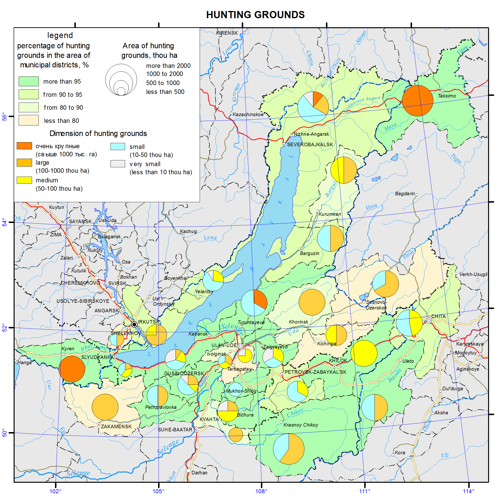
<p>The resource potential of game animals of the Baikal basin has long been characterized by the abundance and high species diversity. This is due to the location of the territory at the intersection of Central-Asian, European-Siberian and East-Asian faunas, where representatives of all of these complexes, including species valuable for hunting, are found. Within the region, there are four typological landscape complexes, corresponding to the zonal and regional landscape subdivisions, namely: mountain-taiga, goletz, forest-steppe, and steppe. Each of them is characterized by a set of habitat types, the quality and quantity of which influence the number of animals.</p>
<p>The wildlife of the <b><i>mountain taiga </i></b>is the richest and most diverse; there manifestations of latitudinal zonality in the distribution of vegetation are complicated by the features of altitudinal zonality of its location in the mountains depending on the steepness and exposure of slopes. This creates prerequisites to spread the spectrum of landscape-ecological diversity of the conditions of animal habitats, and possibilities for most of them to choose the most valuable biotopes and, eventually, to increase in the number. In the mountain taiga squirrel, hazel grouse, sable, bear, and in some places musk deer are numerous. Siberian stag and roe deer inhabiting light slopes, forest openings and woodlots, as well as elk, inhabiting waterlogged intermountain depressions, creek valleys and wide plots of terraces in the coastal area of Lake Baikal, are common. Wolf is numerous in some places; wood grouse and fox are common; lynx and wolverine are less common. Unique populations of reindeer and black-capped marmot survived in high-mountain belts of ridges on both sides of Lake Baikal thanks to the good protection.</p>
<p>Nerpa (Baikal seal) occupies a special place, being the only representative of the family of pinnipeds on Lake Baikal. Its largest rookery is located on the Malye Ushkanyi Islands.</p>
<p>The <b><i>goletz complex</i></b> is characterized by a significantly lower abundance of game animals. Willow and rock ptarmigan, reindeer and ermine belong to permanent residents. This complex can be roughly considered a complementing link to the mountain-taiga one since so many game animals, especially the ungulates, as well as bear, are connected with the highlands by systematic seasonal migrations.</p>
<p>The <b><i>forest-steppe and steppe complexes</i></b> stretch in narrow discontinuous bands in the south of the region. They are represented by the Central-Asian mountain steppes and are not distinguished by the abundance of game animals. Only roe deer in the forest-steppe continues to hold the background position among other species, while tarbagan, once numerous in the steppe, has lost its former significance as a result of plowing of the Transbaikalian steppes and its extermination as a carrier of epizootic plague in the course of antiplague measures. Other species characteristic of the forest-steppe zone, namely, badger and raccoon dog, and of the steppe zone, namely, tolai hare, manul, and dzeren, are small in number. Some of them (dzeren and manul) are protected.</p>
<p>The status of game animals is examined only for the Russian part of the Baikal basin. In connection with the reorganizational measures in the Russian hunting sector over the past two decades, some negative manifestations can be noticed in the usage patterns of species valuable for hunting and in the dynamics of their numbers. A number of problems arose, connected mainly with wild ungulates, especially Siberian stag, roe deer, elk, wild reindeer, and in some places musk deer. Concerning these species ​​an undisputed conclusion was made (as, indeed, for other regions) that “the current dynamics of populations of wild ungulates in Russia is determined mainly by hunters (poachers to a greater extent), large predators, and, locally, snowy winters, and not by a natural cyclicity and changes in the productivity of phytocenoses” [Kozhichev, 2002; Danilkin, 2010].</p>
<p>Among large predators the greatest harm is done by wolves. The wolf problem arose due to the loosening of its control. The damage from this predator to the ungulates (Siberian stag and, especially, roe deer) in different regions of Buryatia reaches 8-30% of the autumn herd [Noskov, 2008]. In recent years, in consequence of the irregular decrease in the number of Siberian stag (poaching and death by predators) in conjunction with the legal shooting in Buryatia a crisis situation with the population of this deer was created [Noskov, 2008]. The damage from wolves only in Transbaikalia in 2011 amounted to11.6 million roubles to agriculture and 70-80 million rubles to hunting [Samoilov, Kayukova, 2013]. Because of the large number of wolves in some areas of Transbaikalia an emergency situation was declared [Samoilov, Kayukova, 2013].</p>
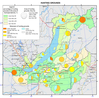
<p>In the current situation, the negative effects are smoothed out to some extent through a network of specially protected natural areas. Thus, in Buryatia, 7-8% of the total number of Siberian stag and roe deer are protected within the territories of 13 nature reserves (zakazniks) and 3 reserved areas (zapovedniks) [Noskov, 2008]. Reindeer is listed in the Red Book of the Republic of Buryatia. Measures to protect the hunting grounds, especially in the areas of concentration of animals, are taken.</p>
<p>Another situation formed with respect to fur-bearing species of hunting. This is due to the fall in world prices for raw fur. Eighteen million pelts of caged mink from China were mass-marketed [Romanov, 2008]. Because of low prices for Chinese mink, squirrel or muskrat fur coats turned out to be more expensive. As a result, squirrel and muskrat are in little demand on the market. The same situation takes place with other species, namely: fox, Siberian weasel, and ermine. Rare lynx and wolverine pelts are used mainly on the domestic market.</p>
<p>A diametrically opposite situation is with sable enabling Russia to achieve a dominant position in the world market as an exclusive supplier of sable fur. Demand and prices for sable pelts have increased. The price for a sable at an auction averages 220-250 dollars. As opposed to the past years, sable is not endangered as there are less professional hunters. Besides, remote hunting lands are not utilized. They have become a kind of sable reserves, where sables multiply and settle throughout the taiga.</p>
<p>The analysis of the status of hunting fauna in the Baikal basin revealed a number of trends in the features of its use, also characteristic of other regions of the country, in particular, the problem of protecting ungulates. A positive phenomenon is a continued status of sable as the leader in the world fur market, and a removal of the danger of its extermination due to changes in socio-economic conditions, which is important in contrast with previous years.</p>
<p>At the same time, unlike the majority of Siberian regions where a trend of rapid increase in the area of publicly available lands accelerated, in the region under consideration this phenomenon is minimized. This is indicative of targeted optimization of the utilization of game animals resources on the basis of improving forms of hunting management and prospects of its development in the region. Thus, the calculations [Dambiev et al., 2011] made it possible to estimate the socio-economic significance of hunting nature management in the Republic of Buryatia in 2010 as amounting to 1.1 billion roubles. Among them natural products of hunting (furs, meat, etc.) are estimated at 150 million roubles, while the social impact of tourism associated with hunting reaches 450 million roubles. The remaining portion is accounted for by other socio-economic relevance. Therefore, the current state of game fauna in the study region is characterized as conditionally stable. As a result of satisfactory organization of protection of game animals in the region, their number corresponds to a primitive stage of market hunting management.<b></b></p>
<p align="center">References</p>
<p>Dambiev, A.G., Kambalin, V.S., and Noskov, V.T. (2011). <i>Hunting nature management of the Republic of Buryatia: problems and prospects.</i> Irkutsk: Izd-vo Irkutskoi  selskokhozyaistvennoi akademii. - 109 p.</p>
<p>Danilkin, A. (2010). <i>Wild ungulates of Russia: patterns of population dynamics, in Okhota i okhotnichie khozyaistvo</i>, no.10, pp. 1-4.</p>
<p>Kozhichev, R. (2002). Siberian roe deer in Irkutsk oblast: what to do? in <i>Okhota i okhotnichie khozyaistvo</i>, , no. 12, pp. 4-5.</p>
<p>Noskov, V.T. (2008). <i>Game animals of Buryatia</i>. Ulan-Ude: Izd-vo FGOU VP. “BGSKhA” im. V.V. Filippova, , 223 p.</p>
<p>Romanov, V.I. (2008). Organizational obstacles for producing hunting fur in Eastern Siberia in Protection and sustainable use of animal and plant resources. <i>Proceedings of the International Scientific Conference, May, 29 – June, 1, 2008</i>. Irkutsk: Izd-vo Irkutskoi selskokhozyaistvennoi akademii, pp. 134-136.</p>
<p>Samoilov, E.B. and Kayukova, S.N. (2013). <i>Invasion of wolves in Transbaikalia</i>.  Irkutsk: Izd-vo IrGSKhA, pp. 261-263.</p>]]></content:encoded>
    <dc:publisher>No publisher</dc:publisher>
    <dc:creator>Alexander Ayurzhanaev</dc:creator>
    <dc:rights></dc:rights>
    <dc:date>2014-10-08T07:55:00Z</dc:date>
    <dc:type>Page</dc:type>
  </item>


  <item rdf:about="http://bic.iwlearn.org/en/atlas/atlas/53-timber-stock-of-the-main-groups-of-forest-forming-tree-species-map/timber-stock-of-the-main-groups-of-forest-forming-tree-species-map">
    <title>Timber stock of the main groups of forest forming tree species map</title>
    <link>http://bic.iwlearn.org/en/atlas/atlas/53-timber-stock-of-the-main-groups-of-forest-forming-tree-species-map/timber-stock-of-the-main-groups-of-forest-forming-tree-species-map</link>
    <description></description>
    <content:encoded xmlns:content="http://purl.org/rss/1.0/modules/content/"><![CDATA[<p><img class="image-inline" src="../../../resolveuid/6c9a45dca85f4516a5d1ce01853851c3/@@images/image/preview" /></p>
<p><a href="http://bic.iwlearn.org/en/atlas/photos/copy_of__53_TimberStockoftheMainGroupsofForestFormingTreeSpecies.png" class="internal-link">Open full size</a></p>
<p align="center"><strong>Forest resources and their use</strong></p>
<p align="center"><strong> </strong></p>
<p>The Baikal basin is a truly enormous treasury of "green gold." As of January 1, 2011 the forest area is 32103.6 thousand hectares in the Russian part of the basin and 10354.3 thousand hectares in Mongolia. Total timber reserves in the Russian part of the basin are 2,795,800,000 m3, with a stock of the conifers 2.443.000.000 m<sup>3</sup> (87.4 %). In Mongolia the total timber reserves is 1.373.100.000 m<sup>3</sup>.</p>
<p>The basic map shows the forests of nature conservation and other preservation patterns, as well as merchantable and other forests, suitable for commercial use, and reserved forests. It should be said that the division of forest lands into protected, merchantable and reserved is characteristic only of the Russian Federation. However, in the territory of Mongolia forests of special importance and in need of protection are distinguished, such as forest areas up to 100 hectares, forests on the slopes of the mountain areas of more than 30 degrees, etc.</p>
<p>Protected forests in Russia include forests subject to reclamation in order to maintain environmental, water protection, safety, sanitation, health and other useful features while using these forests providing compatibility with their intended purpose. Within the Baikal basin there is a high proportion of protected forests, due their ecosystemic, environment protection and water protection functions, as well as the important ecological role of montane forests. Merchantable<b> </b>forests are those which should be developed for the purposes of sustainable, maximum-efficiency rate production of high quality wood and other forest resources, as well as their conversion products ensuring the preservation of beneficial functions of forests. As far as the reserved forests are concerned, those are the forests not planned for logging for next twenty years. These forests are mostly located in the northern part of the region, in the permafrost zone, off-road area and are unattractive for development.</p>
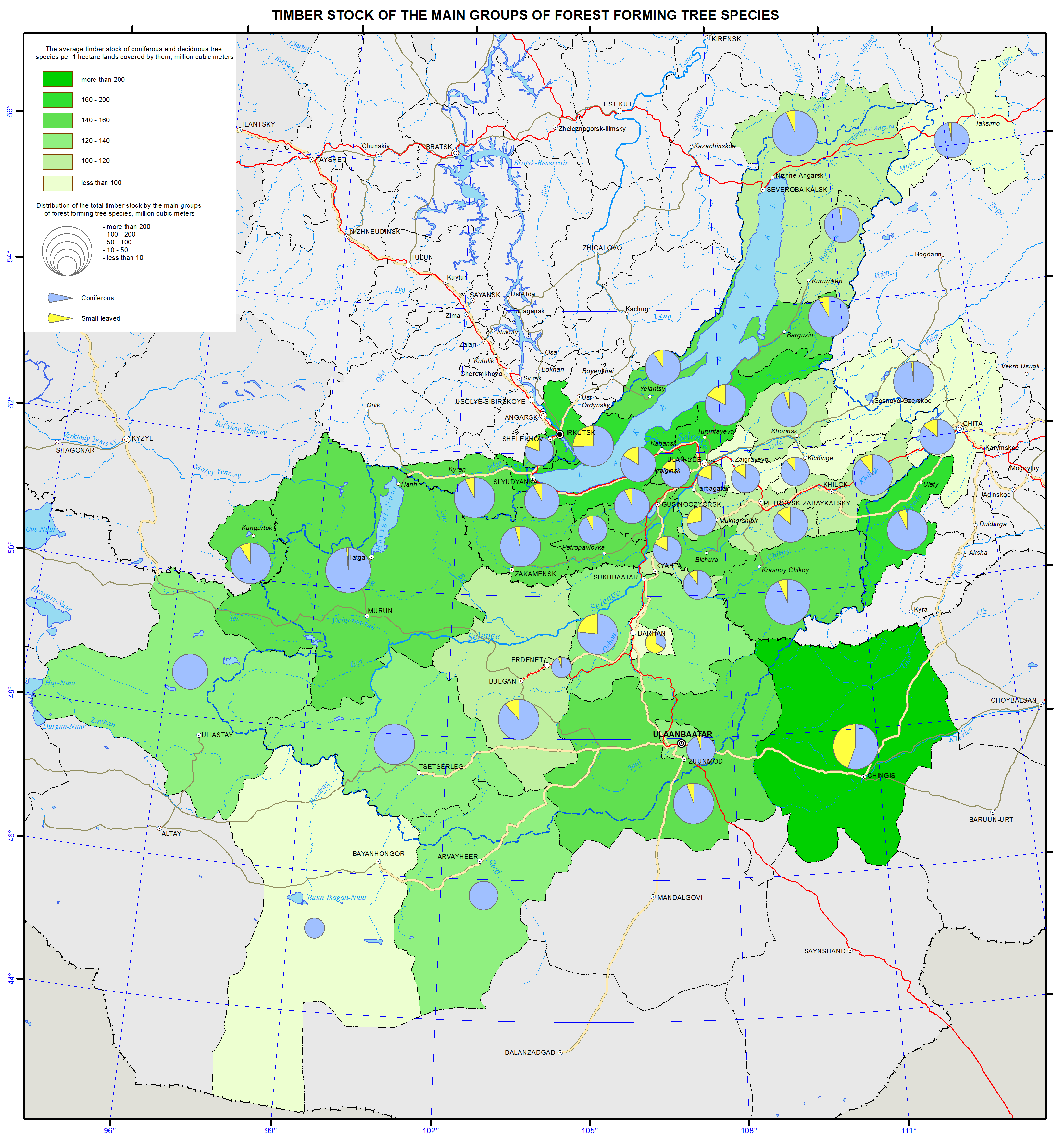
<p>The insert map "Timber reserves by groups of the major forest forming species" shows the average reserves of softwood and hardwood forests (m3) per hectare of land covered by them. The average stand of timber per unit of the covered area is one of the indicators characterizing the productivity of forests, depending on growing conditions of stands, their species, and stands sparsity. The average stand of conifers and deciduous trees per hectare in the Russian part of the Baikal basin is 132.5 m3 (the global average is 100 m3/ha ), and it is fluctuating from 79-82 m3/ha (mostly in the steppe regions of Zabaikalsky krai, the Republic of Buryatia (Zaigraevsky, Chita districts) to 160 -170 m3/ha and up in the mid- and north areas (Uletovsky district of Transbaikalia, Kabansky and Severobaikalsky districts of the Republic of Buryatia, Irkutsky and Slyudyansky districts of Irkutsk oblast). Within the Mongolian part of the basin the average reserve of coniferous and deciduous tree stands is 126.6 m3 per one hectare with fluctuations in the aimaks from 81 to 205 m3 per ha. The highest average stand of timber per unit of forest area is characteristic of the northern mountainous areas of Mongolia.</p>
<p>Also this map shows the distribution of the total stand of timber by major groups of forest forming species (in million m3) with the method of cartodiagram. This index demonstrates forest-resource security area, which varies significantly in the districts of the Russian part of the basin and Mongolian aimaks (from 1.5 to 481 million m3). For correct depiction of the amount of total stand of timber within municipalities a conventional stepped scale for the circular cartodiagram was worked out, which enables to judge about the stands of timber for each group using the percentage between the major groups of forest forming species (coniferous, deciduous and shrubs).</p>
<p>Forest use is determined by the activities that have priority development within the forest vegetation areas. Timber harvesting is most developed among all kinds of forest utilization in the Russian part of the Baikal basin regulated by allowable cutting rates. Forests are actively used for recreation, hunting activities, etc.</p>
<p>In the analysis of forest utilization the following trends for all forests of the Baikal basin are revealed in recent years. They are reduction of coniferous stands, mostly maturing and mature stands; replacement of coniferous species by deciduous ones; widespread illegal logging, reduction of forested area due to fires, forest damage by pests, deforestation, and insufficient reforestation.</p>]]></content:encoded>
    <dc:publisher>No publisher</dc:publisher>
    <dc:creator>Alexander Ayurzhanaev</dc:creator>
    <dc:rights></dc:rights>
    <dc:date>2014-10-08T07:50:00Z</dc:date>
    <dc:type>Page</dc:type>
  </item>


  <item rdf:about="http://bic.iwlearn.org/en/atlas/atlas/52-forest-resources-and-their-use-map/forest-resources-and-their-use-map">
    <title>Forest resources and their use map</title>
    <link>http://bic.iwlearn.org/en/atlas/atlas/52-forest-resources-and-their-use-map/forest-resources-and-their-use-map</link>
    <description></description>
    <content:encoded xmlns:content="http://purl.org/rss/1.0/modules/content/"><![CDATA[<p><img class="image-inline" src="../../../resolveuid/700ad65621bc487bbc5893966fe93356/@@images/image/preview" /></p>
<p><a href="http://bic.iwlearn.org/en/atlas/photos/copy_of__52_Forestresourcesandtheiruse.png" class="internal-link">Open full size</a></p>
<p align="center"><strong>Forest resources and their use</strong></p>
<p align="center"><strong> </strong></p>
<p>The Baikal basin is a truly enormous treasury of "green gold." As of January 1, 2011 the forest area is 32103.6 thousand hectares in the Russian part of the basin and 10354.3 thousand hectares in Mongolia. Total timber reserves in the Russian part of the basin are 2,795,800,000 m3, with a stock of the conifers 2.443.000.000 m<sup>3</sup> (87.4 %). In Mongolia the total timber reserves is 1.373.100.000 m<sup>3</sup>.</p>
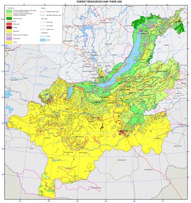
<p>The basic map shows the forests of nature conservation and other preservation patterns, as well as merchantable and other forests, suitable for commercial use, and reserved forests. It should be said that the division of forest lands into protected, merchantable and reserved is characteristic only of the Russian Federation. However, in the territory of Mongolia forests of special importance and in need of protection are distinguished, such as forest areas up to 100 hectares, forests on the slopes of the mountain areas of more than 30 degrees, etc.</p>
<p>Protected forests in Russia include forests subject to reclamation in order to maintain environmental, water protection, safety, sanitation, health and other useful features while using these forests providing compatibility with their intended purpose. Within the Baikal basin there is a high proportion of protected forests, due their ecosystemic, environment protection and water protection functions, as well as the important ecological role of montane forests. Merchantable<b> </b>forests are those which should be developed for the purposes of sustainable, maximum-efficiency rate production of high quality wood and other forest resources, as well as their conversion products ensuring the preservation of beneficial functions of forests. As far as the reserved forests are concerned, those are the forests not planned for logging for next twenty years. These forests are mostly located in the northern part of the region, in the permafrost zone, off-road area and are unattractive for development.</p>
<p>The insert map "Timber reserves by groups of the major forest forming species" shows the average reserves of softwood and hardwood forests (m3) per hectare of land covered by them. The average stand of timber per unit of the covered area is one of the indicators characterizing the productivity of forests, depending on growing conditions of stands, their species, and stands sparsity. The average stand of conifers and deciduous trees per hectare in the Russian part of the Baikal basin is 132.5 m3 (the global average is 100 m3/ha ), and it is fluctuating from 79-82 m3/ha (mostly in the steppe regions of Zabaikalsky krai, the Republic of Buryatia (Zaigraevsky, Chita districts) to 160 -170 m3/ha and up in the mid- and north areas (Uletovsky district of Transbaikalia, Kabansky and Severobaikalsky districts of the Republic of Buryatia, Irkutsky and Slyudyansky districts of Irkutsk oblast). Within the Mongolian part of the basin the average reserve of coniferous and deciduous tree stands is 126.6 m3 per one hectare with fluctuations in the aimaks from 81 to 205 m3 per ha. The highest average stand of timber per unit of forest area is characteristic of the northern mountainous areas of Mongolia.</p>
<p>Also this map shows the distribution of the total stand of timber by major groups of forest forming species (in million m3) with the method of cartodiagram. This index demonstrates forest-resource security area, which varies significantly in the districts of the Russian part of the basin and Mongolian aimaks (from 1.5 to 481 million m3). For correct depiction of the amount of total stand of timber within municipalities a conventional stepped scale for the circular cartodiagram was worked out, which enables to judge about the stands of timber for each group using the percentage between the major groups of forest forming species (coniferous, deciduous and shrubs).</p>
<p>Forest use is determined by the activities that have priority development within the forest vegetation areas. Timber harvesting is most developed among all kinds of forest utilization in the Russian part of the Baikal basin regulated by allowable cutting rates. Forests are actively used for recreation, hunting activities, etc.</p>
<p>In the analysis of forest utilization the following trends for all forests of the Baikal basin are revealed in recent years. They are reduction of coniferous stands, mostly maturing and mature stands; replacement of coniferous species by deciduous ones; widespread illegal logging, reduction of forested area due to fires, forest damage by pests, deforestation, and insufficient reforestation.</p>]]></content:encoded>
    <dc:publisher>No publisher</dc:publisher>
    <dc:creator>Alexander Ayurzhanaev</dc:creator>
    <dc:rights></dc:rights>
    <dc:date>2014-10-08T07:45:00Z</dc:date>
    <dc:type>Page</dc:type>
  </item>


  <item rdf:about="http://bic.iwlearn.org/en/atlas/atlas/49-recreational-resources-of-climate-map/recreational-resources-of-climate-map">
    <title>Recreational resources of climate map</title>
    <link>http://bic.iwlearn.org/en/atlas/atlas/49-recreational-resources-of-climate-map/recreational-resources-of-climate-map</link>
    <description></description>
    <content:encoded xmlns:content="http://purl.org/rss/1.0/modules/content/"><![CDATA[<p><img class="image-inline" src="../../../resolveuid/b13e4cc0ddbc4a00847fc93bb8e655d3/@@images/image/preview" /></p>
<p><a href="http://bic.iwlearn.org/en/atlas/photos/copy_of__49_RecreationalResourcesofClimate.png" class="internal-link">Open full size</a></p>
<p align="center"><b><b>Recreational climate resources</b></b></p>
<p>A complex of several climatic factors, such as high sunshine duration (from 2800 hours per annum in the south of the basin to 1500 hours per annum in the north), wide range of heat supply (the sum of mean daily temperatures above 10° C varies from 2400 in the south of the basin to 244 in the highlands), sustained low temperatures in the hollow land forms, and predominantly low wind velocities contribute to the formation of local climates with highly varied suitability for seasonal recreation. Background climatic characteristics of diverse territories, such as hollow, valley, low-, mid-, and high-altitude vary considerably. Their main features in this case are characterized by a number of differently directed indices, whose combined impact on humans can have a similar effect. The same air temperature has a dissimilar thermal effect on a human body in the case of different wind velocities and different air humidity.</p>
<p>Normal-equivalent-effective temperature (NEET) method is often used to take into consideration their combined influence upon the thermal state of man. The levels of comfortable perception of heat according to the NEET scale vary within a broad range depending on the degree of man’s adaptation to environmental conditions. The use of the duration of NEET values above 8 °C for the background assessment of contrasting territories demonstrated its validity [Bashalkhanova et al., 2012].</p>
<p>Reduced temperature (Qred) indicates heat losses from the open surface of human body in the wintertime under a combined effect of air temperature and wind velocity [Khairulin and Karpenko, 2005]. With Qred below −32 °C, the risk of frostbite increases, so recreation in the open air is limited.</p>
<p>In the total form the complex of the most important characteristics of climatic resources favorable for recreation is represented by the duration of periods with NEET above 8 °C and those limiting it – by Qred below −32 °C.</p>
<p class="a0">Spatial distribution of indicators under study is dependent on a complex interaction of the main climate forcing factors, such as radiative and circulatory ones as well as the underlying surface properties, which provide a variety of mesoclimatic conditions, manifestation of latitudinal and altitudinal zonality elements and local patterns for recreational activity</p>
<p>In summer the variety of landscape conditions exerts considerable influence on climatic regimes formation alongside with the latitudinal factor. The plain-valley mesoclimates combining the steppe, steppificated, and subtaiga piedmont pine landscapes of slopes, plains and river valleys are characterized by the broadest possibilities for recreation and treatment of the population [Landscapes…, 1977; National…1990]. The duration of days with the NEET above 8 °C is highest. Recreational resources of the climate of uplands and mountainous territories are substantially lower; they are characterized by a shorter duration of the favorable period. The duration decreases dramatically depending on the latitudinal and altitudinal location of natural complexes. For instance, for the dark coniferous landscapes of uplands, dark coniferous and larch piedmont and intermontane depressions as well as bogged larch depressions on the plains its duration is from 40 to 70 days. In the mountain-taiga landscapes of flat (sometimes slope) surfaces as well as in dark coniferous landscapes of high slopes and plateaus, this period is less than 40 days. In high mountains with goletz, subgoletz and, partly, mountain-taiga larch forests, the mean monthly NEETs do not reach 8 °C.</p>
<p>The low recreational potential of the climate in winter is conditioned by circulation and astronomical factors. In the subtypes of climates weakly differing in summer (plain-valley, narrow valley and highlands) elements of latitudinal zonality are clearly traced. The period of possible limitation of recreation in the open air in the northern and southern parts of the basin can differ nearly twofold. Meanwhile the stagnant phenomena in orographically isolated intermontane depressions and closed river valleys are accompanied by the longest period of Qred below −32 °C, which reveals more favorable conditions on their slopes. The severity of winters for open surfaces of slopes and summits obeys the wind regime.</p>
<p>Quite special conditions occur on the shores of Lake Baikal. The warming (in winter) and cooling (in summer) influence of the lake’s water masses showed a shift toward a decrease in climatic-physiological comfort of landscapes when compared with their counterparts outside the influence zone. This is largely due to the large horizontal temperature gradients between land and lake, which are often the cause of strong winds, the exceptional variety, unpredictability and velocity of which are well known. For that reason, on certain parts of the shore, especially in the west, in the mountain-taiga pine and larch landscapes the number of days with the NEET above 8 °C is lowest (less than 40 days). Meanwhile, in the wind-proof parts of the shore (Peschanaya Bay, the Kuchelga river valley, etc.) the conditions for recreation are optimal. In winter the dependence of the climatic-recreational potential on the location grows even further. In some shore areas relatively favorable in the summer season, the length of the period of reduced temperature below −32 °C differs substantially.</p>
<p>On the whole, the recreation resources of the climate across the territory are relatively varied. Given the availability of mud-bath resources in the depressions and broad river valleys with a shorter length of the limiting period, there is a possibility of launching the sanatorium-and-spa treatment. Of considerable interest are the middle mountains of Khangai and the interfluves of the Selenga and Orkhon rivers. The climatic resources of other territories are more suitable for extensive development and promotion of tourism and stationary recreation. Because of the low heat availability and abrupt fluctuations in the temperature-wind regime, the shores of Lake Baikal and Lake Hovsgol are favorable for recreation of healthy people only. Obviously, depending on the characteristics of heat and moisture exchange and on the regime of the local circulation, the period for different kinds of recreation is variable. Thus, the slopes of the Khamar-Daban on the southern shores of Lake Baikal are most favorable for the winter kinds of recreation due to the abundance of snow, and the appropriate combination of temperature and wind regimes. The shores of Middle Baikal characterized by a long duration of sunshine are more favorable for summer recreation.</p>
<p class="a0">The experience of the cartographic analysis and multiscale assessment of recreational resources of the climate showed that in a number of cases climate resources essential for the recreation of people and conditioned by microclimatic differences may considerably exceed their latitudinal background parameters. Thus, a comprehensive expert examination of the recreational resources of the climate is important when a certain area is selected for implementation of investment projects.</p>
<p align="center">References</p>
<p>Bashalkhanova, L.B., Veselova, V.N. and Korytny, L.M. (2012). <i>Resource Dimension of Social Conditions for the Life of the Population of East Siberia</i>, Novosibirsk: Geo, 221 p. [in Russian].</p>
<p><i>Landscapes of the South of East Siberia (1:1 500 000 Map)</i>. (1977). V.S. Mikheev and V.A. Ryashin, Moscow: GUGK, 4 sh. [in Russian].<i></i></p>
<p><i>Mongol ulsyn undesnii atlas</i>. (2009). Ulaan-Baatar: SHUA. Gazarzuin khurzelen. - 248 p. [in Mongolian].</p>]]></content:encoded>
    <dc:publisher>No publisher</dc:publisher>
    <dc:creator>Alexander Ayurzhanaev</dc:creator>
    <dc:rights></dc:rights>
    <dc:date>2014-10-08T07:25:00Z</dc:date>
    <dc:type>Page</dc:type>
  </item>


  <item rdf:about="http://bic.iwlearn.org/en/atlas/atlas/48-mineral-waters-map/mineral-waters-map">
    <title>Mineral waters map</title>
    <link>http://bic.iwlearn.org/en/atlas/atlas/48-mineral-waters-map/mineral-waters-map</link>
    <description></description>
    <content:encoded xmlns:content="http://purl.org/rss/1.0/modules/content/"><![CDATA[<p><img class="image-inline" src="../../../resolveuid/c6afd68e36b64110bdddd43d637b238c/@@images/image/preview" /></p>
<p><a href="http://bic.iwlearn.org/en/atlas/photos/copy_of__48_Mineralwaters.png" class="internal-link">Open full size</a></p>
<p align="center"><strong>Mineral springs</strong></p>
<p align="center"><strong> </strong></p>
<p>The map is based on generalizing monographs, maps of mineral waters and field research data obtained by the authors.</p>
<p>The map depicts mineral springs, the water of which can be used for balneological purposes according to its physical and chemical properties. These characteristics include: water temperature (hot springs); radon content (cold radon springs), content of free carbon dioxide (carbonic cold springs), content of sulphate sulfur (cold hydrogen sulfide springs) and iron (ferrous cold springs).</p>
<p>This map can be used for the organization of sanatorium-and-spa construction, as well as for planning of underground thermal water use in thermal engineering.<b> </b></p>
<p align="center">References</p>
<p>Borisenko, I.M., Zamana, L. (1978). <i>Mineral water of Buryatia</i>. - Ulan-Ude: Buryat kn. izd-vo. - 163 p.</p>
<p>Map of the Republic of Tyva (tourism objects, objects of nature, arzhaans, photos).(2012). - M1:1000000, Kyzyl.</p>
<p>Lomonosov, I.S., Kustov, Yu.I., Pinneker, E.V. (1977). <i>Mineral water in Baikal region</i>. – Irkutsk: Vost. Sib . kn. izd-vo. - 224 p.</p>
<p><i>Mineral water of southern part of Eastern Siberia.</i> Vol.II. (1962) – M.-L.: Izd. AN USSR. - 199 p.</p>
<p>Pissarsky, B.I., Nambar, B, Ariyadagva, B. (2003). <i>Map of mineral waters in Mongolia</i>. 1:2500000, - Ulaanbaatar.</p>]]></content:encoded>
    <dc:publisher>No publisher</dc:publisher>
    <dc:creator>Alexander Ayurzhanaev</dc:creator>
    <dc:rights></dc:rights>
    <dc:date>2014-10-08T05:50:00Z</dc:date>
    <dc:type>Page</dc:type>
  </item>


  <item rdf:about="http://bic.iwlearn.org/en/atlas/atlas/45-main-types-of-non-metallic-materials-map/main-types-of-non-metallic-materials-map">
    <title>Main types of nonmetallic materials map</title>
    <link>http://bic.iwlearn.org/en/atlas/atlas/45-main-types-of-non-metallic-materials-map/main-types-of-non-metallic-materials-map</link>
    <description></description>
    <content:encoded xmlns:content="http://purl.org/rss/1.0/modules/content/"><![CDATA[<p><img class="image-inline" src="../../../resolveuid/e609421c005a4d33a8cad29965afb9ce/@@images/image/preview" /></p>
<p><a href="http://bic.iwlearn.org/en/atlas/photos/copy_of__45_Maintypesofnonmetallicmaterials.png" class="internal-link">Open full size</a></p>
<p><img class="image-inline" src="../../../../resolveuid/b1d7d06c2c2f41659de254b9f3dcf0e7/@@images/image/preview" /></p>
<p><a href="http://bic.iwlearn.org/en/photos/copy_of__45_Table_Legend_Maintypesofnonmetallicmaterials.png" class="internal-link">Open full size</a></p>
<p align="center"><strong>The main types of nonmetallic raw materials: resources and development</strong></p>
<p>Nonmetallic mineral resources of the region are of great industrial importance. Within the Baikal basin there are deposits of mining-chemical, thermo-chemical, and optical raw materials, construction materials, mineral fertilizers, ornamental and precious stones.</p>
<p>Deposits of <i>raw quartz </i>belong to strategic types of mineral resources. The region has a large raw materials base explored and prepared for industrial development: there are deposits of especially pure granular quartz (Chulbonskoe, Nadyozhnoe, Goudzhekitskoe, and others) and quartzites (Cheremshanskoe and Goloustenskoe). The vast majority of deposits are located in the territory of Buryatia; there are all prerequisites for creating a large complex of plants for deep processing of raw quartz for high-tech industries. In prospect, the republic can become the largest producer and exporter of polysilicon and total energy systems. Currently, there is a development project of the Chulbonskoe granular quartz deposit in the Severobaikalsky municipal district to get the end-product in the form of photovoltaic systems.</p>
<p>Quartzites of the mined Cheremshanskoe deposit are of exceptionally high raw materials quality meeting industrial requirements for the production of industrial silicon, silicon carbide and ferrosilicon; in recent years, research is carried out on the purest varieties to produce high-purity silicon for  helioenergetics and growing of single crystals of piezoelectric quartz. The deposit has been mined since 1992 by ZAO (Closed Joint Stock Company) “Cheremshansky quartsit” with an annual output of about 200 thousand tons and is a mineral resource base of ZAO (Closed Joint Stock Company) “Kremniy” of the OK (United Company) RUSAL, one of the most cutting edge silicon production facilities in Russia and the country's only producer of refined silicon .</p>
<p>Quartzites of the Goloustenskoe deposit can be used in metallurgy, and in the production of silica bricks. Sources of high-quality abrasive raw materials are microquartzites of two large deposits, located in the Olkhonsky municipal district on the eastern slope of the Baikal Range, namely, Srednekedrovoe and Zavorotninskoe. The latter was developed from 1975 till 1993 by “Baikalkvartssamotsvety”; currently, the deposits are on the governmental standby.</p>
<p>Considerable reserves of raw <i>fluorspar </i>were explored in the Baikal basin in the Republic of Buryatia. Currently, one deposit is mined here. It is the medium Egitinskoe deposit in the Eravninsky district; extracted ore is processed at the ore-dressing plant of the Zabaikalsky mining complex. The Naranskoe deposit in the Selenginsky district was prepared for operation and was mined for some time. The Kyakhtinskaya fluorspar factory operated near the settlement of Khoronkhoy from 1966; first it worked on local raw materials, and then on raw materials imported from Mongolia. Currently, the factory is out of operation.</p>
<p>The region possesses large reserves of chemically pure <i>limestone</i>s: in the Olkhonsky municipal district there is the Ust-Anginskoe deposit, and in the Zaigraevsky district there is the Bilyutinskoe deposit developed for the production of calcium carbide and the Tatarsky Klyuch for the paint and coatings industry. Dolomites of the Tarabukinskoe deposit are used as a raw material for glass and metallurgical production.</p>
<p>Deposits of <i>phosphate</i> raw materials are known in Cisbaikalia. They are the Sarminskoe phosphorite deposit in the Olkhon municipal district and the Slyudyanskoe apatite deposit in the Sludyansky municipal district; in northern Mongolia large reserves of formation phosphorites in the Khovsgol phosphorite basin were discovered and previously explored. The main deposits of the basin are located in the immediate vicinity of Lake Khovsgol, which is an obstacle to their development. The large Oshurkovskoe apatite deposit is prepared for exploitation near the city of Ulan-Ude. On the basis of the approved ready reserves the Zabaikalsky apatite plant was under construction; it was closed down at the building phase of an ore-dressing plant because of possible deterioration of the environmental situation in the Baikal basin. Currently, there is a project of the deposit’s development based on environmentally friendly technologies for the extraction and beneficiation of ores. Taking into account a sustained deficit of phosphate raw materials in the country, an increase of the raw materials base for the production of phosphate fertilizers is a matter of economic security of Russia. The planned standard of production of apatite concentrate is 500 thousand tons per annum. Breakstone will be produced as a by-product in the same amount of 500 thousand tons per annum.</p>
<p>Considering the <i>ceramic and fire-resisting raw materials</i>, deposits of Irkutsk oblast should be pointed out. They are the Naryn-Kuntinskoe microcline pegmatite deposit, developed earlier for the needs of the “Sibfarfor” factory, the Kharginskoe glass sands deposit, on the basis of which the Taltsy plant was established in 1784 producing a variety of glass products for 170 years, and the Asyamovskoe deposit of wollastonite, a relatively new kind of mineral products with a number of unique properties and a growing range of applications. In the south of Buryatia a sillimanite (high-alumina) shales deposit named Chyornaya Sopka is known; its ores have simple mineral composition and are easily dressed. On the basis of the deposit a non-waste production with the release of sillimanite and quartz as commercial products can be created. All the above mentioned deposits are currently on the governmental standby.<i> </i></p>
<p><i>Phlogopite mica</i> deposits in the south of Lake Baikal have been known since the second half of the 18<sup>th</sup> century. Its regular commercial production using a ramified system of underground (tunnels, mines) and open (open pits) mine openings began in 1924 with the development of the electrical engineering industry in the country and lasted until 1973. From four to seven thousand tons of high-quality raw materials were mined annually in the Sludyansky district.<i></i></p>
<p><i>Graphite </i>is represented in the region by two large deposits, namely, the Bezymyannoe (the Slyudyansky municipal district) and Boyarskoe (the Kabansky municipal district) deposits. Ores of the Bezymyannoe deposit are high quality and free-milling according to the manufacturer's tests, but the deposit is located in close proximity to Lake Baikal. The Boyarskoe deposit has the largest reserves. Economic efficiency of its development in compliance with all environmental requirements can be quite high despite low average graphite content in the ore, thanks to its favorable transportation and geographical location.</p>
<p>In the past, a considerable part of the Baikal basin experienced intense volcanic activity, the product of which is <i>pearlite</i> deposits, among which the largest ones are Mukhor-Talinskoe, Zakultinskoe, and Kholinskoe. Currently, this raw material is produced by OAO (Joint Stock Company) “Perlit” on the Mukhor-Talinskoe deposit with the production output amounting to 1-10 thousand m<sup>3</sup> of raw material per annum over the last three years. The Kholinskoe pearlite and zeolite deposit is located on the border of the Republic of Buryatia and Zabaikalsky krai; the mining OOO (Limited Liability Company) “Kholinskie tseolity” develops the deposit. Nowadays, the capacity of the company mining such a valuable kind of mineral product as zeolites is small and amounts to only about 0.8 thousand tons.</p>
<p>Within the region there are a number of deposits of <i>precious and ornamental stones</i>. In Zabaikalsky krai, ZAO (Closed Joint Stock Company) “Turmalkhan” develops a unique deposit of jewelry tourmaline, which is the only one in Russia to date. In the Republic of Buryatia, OOO (Limited Liability Company) “Kaskad” exploits the Khargantinskoe deposit with an annual production of 20 tons of raw jade; ZAO (Closed Joint Stock Company) “MS Holding” started to develop the Khamarkhudinskoe jade deposit, where 510 tons were produced in 2012.</p>
<p>To meet the needs of the construction industry the region possesses significant resources of <i>mineral construction materials</i>: numerous deposits of cement, brick, sand and gravel raw materials, building and facing stone are explored in the area. The raw materials base of the Angarsky cement plant is the large Slyudyanskoe deposit of cement marbles, being developed by the OOO (Limited Liability Company) “Karyer Pereval” with an annual output of about 900 thousand tons. The Tarakanovskoe deposit of cement limestone and Timlyuiskoe deposit of loam supply the Timlyuisky cement plant with raw materials. OOO (Limited Liability Company) “Timlyuitsement” produces 250-400 thousand tons of limestone and 20-35 thousand tons of loam annually.</p>
<p>Facing stone deposits are located on the western and south-eastern shores of Lake Baikal; they are Burovshchina and Novo-Burovshchinskoe deposits of pink marbles and Buguldeiskoe deposit of highly-ornamental statuary marble of various color shades: from snow-white to smoky-gray. Currently, stone is not produced on any of these deposits. Among building stone deposits AO (Joint Stock Company) RZhD exploits two: one of them is the medium Angasolskoe deposit in Irkutsk oblast and the other is the large Zhipkhegenskoe deposit in Zabaikalsky krai forming the raw materials base of the same-name crushed stone plants. Several deposits of building stone are situated in the coastal zone of Lake Baikal, namely, Baikalskoe, Ermolaevskoe, Dinamitnoe and others, rendering their development impossible.</p>
<p>The following deposits of brick and keramzite claysand loams were discovered: the Murinskoe and Khuzhirskoe deposits in Cisbaikalia and Irkaninskoe deposit in the Severobaikalsky municipal district, deposits of sand-gravel mix, including the Utulikskoe deposit of high-quality raw materials, the Pankovskoe deposit of building sands, and so on.</p>
<p>Among <i>other</i> mineral resources of the region, the Zangodinskoe and Kalinishenskoe deposits of mineral paints, Khayanskoe deposit of drilling clays, several deposits of raw materials for stone casting, as well as deposits of mineral salts (sodium sulfate) should be mentioned. All deposits of these raw materials are small in terms of reserves and are on the governmental standby.</p>
<p>In Mongolia small deposits of asbestos, gypsum, graphite, talcum, magnesite, bentonite, ornamental stones (nephrite, serpentinite, lapis lasuli, ophicalcite, chalcedony, etc.), raw quartz, and mineral salts are known within the Baikal basin. As for construction materials there are deposits of building sand, brick, keramzite and ceramic clays, sand-gravel mix, building stone, etc.</p>
<p>The map presents the main nonmetallic mineral raw materials deposits, depending on their size and type of mineral product, as well as mining companies using symbols. The size of the symbol designating a company depends on the average production output over the recent three to five years or on the planned capacity of the objects designed and under construction; gradation is presented in the summary table. The color of the symbol corresponds to the operational phase of an enterprise. The Khubsugulsky phosphorite basin is shown with an areal.</p>
<p>Map construction required the use of the materials of the Regional Funds of Geological Information, maps of mineral resources of the A.P. Karpinsky Russian Geological Research Institute; materials of State Reports “On the Condition of Lake Baikal and Measures of its Protection” for 2010–2012; “National Atlas of the Mongolian People's Republic” (1990), “Atlas of Mongolia” in the Mongolian language (2010), and “Atlas of Socioeconomic Development of Russia” (2009). Information on deposits according to the types of raw materials and on mining companies is presented in the summary table.</p>
<p><img class="image-inline" src="../../../../resolveuid/d284b6f61e4c44f8ad43d46a668322d3/@@images/image/preview" /></p>
<p><a href="http://bic.iwlearn.org/en/photos/45.jpg" class="internal-link">Open full size</a></p>
<p><img class="image-inline" src="../../../../resolveuid/98bbb5cc2eef41158328f7f0eeb57425/@@images/image/preview" /></p>
<p><a href="http://bic.iwlearn.org/en/photos/451.jpg" class="internal-link">Open full size</a></p>
<p><img class="image-inline" src="../../../../resolveuid/a62eb843c052454cb3739df217414e92/@@images/image/preview" /></p>
<p><a href="http://bic.iwlearn.org/en/photos/452.jpg" class="internal-link">Open full size</a></p>
<p><img class="image-inline" src="../../../../resolveuid/6a6a2fd6be0d47ea9f98156bdefaf7d7/@@images/image/preview" /></p>
<p><a href="http://bic.iwlearn.org/en/photos/453.jpg" class="internal-link">Open full size</a></p>
<p><img class="image-inline" src="../../../../resolveuid/ae9af4a5656a4070a90f7207e47a3c60/@@images/image/preview" /></p>
<p><a href="http://bic.iwlearn.org/en/photos/454.jpg" class="internal-link">Open full size</a></p>
<p><img class="image-inline" src="../../../../resolveuid/dd33f181df6e436c924598b054fbd494/@@images/image/preview" /></p>
<p><a href="http://bic.iwlearn.org/en/photos/455.jpg" class="internal-link">Open full size</a></p>
<p><img class="image-inline" src="../../../../resolveuid/17b13986651f47f7bbddb28738053f17/@@images/image/mini" /></p>
<p><a href="http://bic.iwlearn.org/en/photos/456.jpg" class="internal-link">Open full size</a></p>]]></content:encoded>
    <dc:publisher>No publisher</dc:publisher>
    <dc:creator>Alexander Ayurzhanaev</dc:creator>
    <dc:rights></dc:rights>
    <dc:date>2014-10-08T01:50:00Z</dc:date>
    <dc:type>Page</dc:type>
  </item>


  <item rdf:about="http://bic.iwlearn.org/en/atlas/atlas/44-ferrous-nonferrous-rare-and-precious-metal-resources-and-their-extraction-map/ferrous-nonferrous-rare-and-precious-metal-resources-and-their-extraction-map">
    <title>Ferrous, nonferrous, rare and precious metal resources and their extraction map</title>
    <link>http://bic.iwlearn.org/en/atlas/atlas/44-ferrous-nonferrous-rare-and-precious-metal-resources-and-their-extraction-map/ferrous-nonferrous-rare-and-precious-metal-resources-and-their-extraction-map</link>
    <description></description>
    <content:encoded xmlns:content="http://purl.org/rss/1.0/modules/content/"><![CDATA[<p><img class="image-inline" src="../../../resolveuid/c0893da58701459699e0f5004007f3b0/@@images/image/preview" /></p>
<p><a href="http://bic.iwlearn.org/en/atlas/photos/copy_of__44_Ferrousnonferrousrareandpreciousmetalresourcesandtheirextraction.png" class="internal-link">Open full size</a></p>
<p><img class="image-inline" src="../../../../resolveuid/086337cddf4549b08338fd489baddd69/@@images/image/preview" /></p>
<p><a href="http://bic.iwlearn.org/en/photos/copy_of__44_Table.png" class="internal-link">Open full size</a></p>
<p align="center"><strong>Resources of ferrous, nonferrous and rare metals and their mining</strong></p>
<p>Geological exploration exposed over 150 deposits of metallic minerals within the Baikal basin.<b> </b></p>
<p><b>Ferrous metals</b> are represented by a number of iron ore deposits of different genetic types, including two small magnetite deposits, namely, Balbagarskoe in the territory of the Khorinsky municipal district of the Republic of Buryatia and Baleginskoe in the Petrovsk-Zabaikalsky district of Zabaikalsky krai. In the 18<sup>th</sup>-19<sup>th</sup> centuries the Baleginsky mine supplied iron ore to the Petrovsky plant to procure iron and steel for the mines of the Nerchinsky district. In the Olkhonsky municipal district of Irkutsk oblast small iron ore deposits are known; they are mainly represented by brown iron ore deposits (Borsoiskoe, Kuchelginskoe, etc.). In the first half of the 18<sup>th</sup> century, ore from these deposits was used for the needs of the Anginsky (Laninsky) ironworks. The most promising iron ore deposits of Mongolia are the skarn type deposits such as Tumurtolgoy, Bayangol, and Tumurtey, forming the Bayangol iron ore zone in the north of the country. Currently, iron ore deposits in the region are developed only in the territory of Mongolia: small scale extraction of iron ore is underway on the Zakhtsag and Tamir gol deposits; over the recent years, the production on the deposits of the Bayangolskaya iron ore zone amounted to more than five million tons; primary processing is performed at the cleaning plants near the deposits; iron-ore concentrate is exported to China.</p>
<p>The Oldakit manganese deposit, medium in terms of reserves, is located in the Severobaikalsky municipal district less than 30 km from the Baikal-Amur Mainline. Given the fact that Russia is currently experiencing shortage of this raw material, the deposit may be of some interest. Moreover, several small deposits of manganese are known within the boundaries of the Baikal basin, including the Ozerskoe deposit (Olkhonsky district) developed in the 19<sup>th</sup> century for the needs of the Nikolaevsky ironworks.<b></b></p>
<p><b>Nonferrous metals</b>. Almost all reserves and resources of copper ores of the region are concentrated in complex copper-molybdenum and molybdenum-tungsten deposits of Mongolia, located within the Selenginsky volcanoplutonic belt. From 1978 to present a large deposit Erdenetiyn ovoo has been developed; on its basis a joint Soviet-Mongolian venture, the Erdenet Mining Company was established. The plant is engaged in open-pit mining and primary processing of copper-molybdenum ores and is one of the world leaders in the production of copper concentrate. Currently, the production output amounted to more than 25 million tons of ore, while the production of copper concentrate is about 350 thousand tons. In a globalizing world economy, the company faces the challenge of marketability of its products, which necessitates the construction of a copper-smelting plant. At present, the Erdenet Mining Company comprises a pilot plant for the production of pure cathode copper from off-balance and storage ore dump piles of KOO (Limited Liability Company) “Erdmin”, which is a joint venture of Erdenet Mining Company and the American company RCM.</p>
<p>Within the Baikal basin, the largest Kholodninskoe deposit of lead-zinc sulfide ores is explored and prepared for industrial development; its reserves amount to 11.2% of Russia’s total lead reserves and 34.1% of Russia’s total zinc reserves. Based on the economic indicators of development, the deposit is on par with the best world analogues. According to the feasibility study of final mining parameters, the annual production of the underground mine at the deposit should amount to three million tons of ore, 504 thousand tons of zinc concentrate, and 60.3 thousand tons of lead concentrate. In order to ensure environmental safety of production, provision is made for a circulating water supply system, transportation of wastes of the ore-dressing plant outside the catchment area of Lake Baikal using pipelines, and a number of other environmental measures. However, due to the fact that the deposit is located in the Central Ecological Zone of the Baikal Natural Territory (BNT), where mining activity is banned, the production license, owned by the KOO (Limited Liability Company) “InvestEuroCompany” was suspended until 2015. Among other objects of polymetallic raw materials in the region, the medium Davatkinskoe deposit, discovered and assessed in the Khorinsky municipal district of the Republic of Buryatia, should be pointed out.</p>
<p>In Buryatia there are two large deposits of molybdenum ores, namely, Zharchikhinskoe and Malo-Oinogorskoe, and small Pervomaiskoe (abandoned) and Dolon-Modonskoe (undeveloped) deposits. There is a project of the construction of the Pribaikalsky mining and processing plant on the basis of the Zharchikhinskoe deposit, located 40 km to the south of Ulan-Ude in close proximity to the highway and railway, with the molybdenum content in the ore of more than 0.1% and high technological and technical-economic indicators. Its effective development is possible, provided that all necessary environmental requirements are observed.</p>
<p>Tungsten in the region belongs to widespread elements. In the territory of the Zakamensky municipal district there is the Inkurskoe deposit of the stockwork geological-industrial type, which is comparable to the largest similar deposits of the world in terms of its reserves and tungsten content. The Kholtosonskoe deposit, located to the west of the Inkurskoe one, is the largest deposit of the vein type in Russia, and is considered to be unique not only in Russia but also in the world as to its characteristics. The Dzhidinsky tungsten-molybdenum mill operated from 1934 to 1996 on the basis of these two deposits as well as the Pervomaiskoe molybdenum deposit. After the closure of the mill, the tailings pond remained over the area of more than ​​one km<sup>2</sup>, forming the man-made Barun-Narynskoe deposit, the development of which has been started by OAO (Open Joint Stock Company) “Zakamensk” since 2010. A reclamation plant recycling the mill’s waste was built 1.5 km from the town of Zakamensk; the concentrate production amounts to about 300 tons per annum. ZAO (Closed Joint Stock Company) “Tverdosplav” is engaged in the construction of mining sites at the Inkurskoe and Kholtosonskoe deposits. It is planned to build a modern ore-dressing plant and a hydrometallurgical workshop for the processing of tungsten concentrates to produce commercial refined tungsten compounds. In the Petrovsk-Zabaikalsky municipal district of Zabaikalsky krai the prospectors' artel “Kvarts” mines the medium Bom-Gorkhonskoe tungsten deposit by the underground mining method. In recent years, the concentrate production amounted to around 600 tons. The remaining tungsten deposits within the territory of the Russian part of the Baikal basin are temporarily abandoned or are on the governmental standby.</p>
<p>A number of tungsten deposits are known in Mongolia. A small tungsten refinery plant was built on the Tsagaan davaa deposit; the concentrate production amounts to about 40 tons per annum; the final production is exported to the United States and China.</p>
<p>Tin deposits located in the Krasnochikoysky district are small in terms of reserves and are currently mothballed.</p>
<p>In the Dzhidinsky district of Buryatia the medium Borgoiskoe (Al2O3 – 19.8% on average) and Botsinskoe (21.44%) deposits of nepheline-bearing rocks are prospectively explored; currently they remain undeveloped.<b></b></p>
<p><b>Rare metals.</b> In the Kizhinginsky municipal district of the Republic of Buryatia there is the Ermakovskoe deposit of beryllium ores containing 80% of the total beryllium reserves of Russia and unique as to the grade of ore. From 1978 the deposit was developed by the Zabaikalsky mining and processing plant; in 1990 the enterprise was mothballed. Beryllium is a strategic metal essential for the development of nuclear, aerospace, and aviation industry, and instrument engineering; it is used in the manufacture of telecommunications equipment. Currently, Russia’s demand of this metal is met through imports. Whereas it is necessary to restore the raw material and production independence of the country in beryllium, it is expected to resume the production of ore on the deposit, and create production on primary processing of ore, as well as hydrometallurgical production, the end product of which – beryllium hydroxide – will be delivered to the Ulbinsky metallurgical plant in Kazakhstan for processing and producing beryllium alloying compositions and metal. The work to create the beryllium production is included in the Federal Target Program on rare metals of paramount importance.</p>
<p>In the Severobaikalsky municipal district within the Central Ecological Zone of the BNT, three subsoil plots of the Federal importance with large prognostic resources of rare earth elements of the yttrium group are on the governmental standby. They are the Chestenskoe, Akitskoe and Pryamoy-II deposits.<b></b></p>
<p><b>Noble metals. </b>Within the Russian part of the Baikal basin there are no lode gold deposits (except the mined-out Voskresenskoe deposit in the Krasnochikoysky municipal district). Placer gold deposits are small or medium and are grouped into the gold-placer regions, namely: Dzhidinsky, Namaminsky, Yambuy-Tolutaisky, Chikoysky, and Baldzhikansky. In the Republic of Buryatia within the territory under consideration gold practically has not been produced over the recent three years (economically advantageous deposits are mined-out, and exploration and appraisal works require substantial expenditures); in the Krasnochikoysky district of the ​​Zabaikalsky krai, four prospectors' artels produce 300-400 kg of gold annually using the open-pit hydromechanical method.</p>
<p>Gold is the second most significant mineral resource of Mongolia after copper. The industrial mining of gold ores in the country was launched in the early 20<sup>th</sup> century by the Russian-Mongolian joint-stock company “Mongolor” in the Iro-Gol river basin, in the Khovsgol region and in the Boroo area. Primary deposits are usually of the vein type, more rarely – mineralized zones. The most significant primary deposits in terms of reserves include the Boroo deposit in the Boroo-Zuunmod region and the Bumbat deposit in the Zaamarsky gold field. The metal content in individual layers reaches 10 g/t. The deposits are developed by Canadians with the annual production of five and 1.5 tons of metal, respectively. Moreover, gold is currently mined on the Narantolgoy and Nariyn gol deposits.</p>
<p>Among the placers small and medium ones predominate, and only single ones are large placers in terms of reserves. Most placers are shallow single-layer, rarely double-layer; in rare cases deep placers occur. Dredging and separate production techniques are applied at the placer deposits. After mining by large companies, the remaining gold is mined by individual prospectors, whose number exceeded 10 thousand people according to the official data alone. In river valleys, where mining is possible, huge settlements are formed. As a result, in recent years the country faced an intensive shallowing and pollution of rivers, shrinking of grazing lands for cattle, and a process of desertification of the southern territory, and drinking water shortages for population occur. This is largely due to huge volumes of gold mining in the river valleys, illegal use of mercury and cyanides, and almost total lack of reclamation.</p>
<p>The map symbols show metallic mineral deposits depending on their size and type of commercial minerals. Mining companies are also shown with symbols. The size of a symbol corresponds to the production output. The group of large companies include ferrous, nonferrous and rare metals producing enterprises with production ranging from 1 to 10 million tons of ore per annum, the group of medium ones comprises the production output of 0.1-1 million tons per annum,</p>
<p><img class="image-inline" src="../../../../resolveuid/b5bd74556d5045bcac18238e545cd3c4/@@images/image/preview" /></p>
<p><a href="http://bic.iwlearn.org/en/photos/44.jpg" class="internal-link">Open full size</a></p>
<p><img src="http://bic.iwlearn.org/en/photos/441.jpg/@@images/9854ac0a-f6fc-46c7-b910-b40a35514466.jpeg" alt="" class="image-inline" title="" /></p>
<p><a href="http://bic.iwlearn.org/en/photos/441.jpg" class="internal-link">Open full size</a></p>
<p>and small ones produce less than 0.1 million tons per annum. The Erdenet Mining Company is highlighted as a very large enterprise with an annual production of more than 20 million tons. The following gradation is accepted for gold mining: large companies are gold mines with the production of more than one ton per annum, medium companies are those producing 0.1-1 ton, and small ones are those with less than 0.1 tons produced. The color of the symbol corresponds to the exploitation phase of an enterprise: operating or projected and under construction; additional outline corresponds to the underground mining method. Gold-placer regions of the given territory are depicted by areals.</p>
<p>Table 1</p>
<p><img class="image-inline" src="../../../../resolveuid/f4a37e81d4d7431fbf95f7265a1b458e/@@images/image/preview" /></p>
<p><a href="http://bic.iwlearn.org/en/photos/442.jpg" class="internal-link">Open full size</a></p>
<p><img class="image-inline" src="../../../../resolveuid/1441b8be04934550bc0ebb4c83b9c44e/@@images/image/preview" /></p>
<p><a href="http://bic.iwlearn.org/en/photos/443.jpg" class="internal-link">Open full size</a></p>
<p><img class="image-inline" src="../../../../resolveuid/98c96c25632e4b9dba75b2fc82411706/@@images/image/preview" /></p>
<p><a href="http://bic.iwlearn.org/en/photos/444.jpg" class="internal-link">Open full size</a></p>
<p><img class="image-inline" src="../../../../resolveuid/1daaaef9f0114fa981b1592254b6aace/@@images/image/preview" /></p>
<p><a href="http://bic.iwlearn.org/en/photos/445.jpg" class="internal-link">Open full size</a></p>
<p><img class="image-inline" src="../../../../resolveuid/447e28e1422745858950a3147aee5e36/@@images/image/preview" /></p>
<p><a href="http://bic.iwlearn.org/en/photos/446.jpg" class="internal-link">Open full size</a></p>
<p><img class="image-inline" src="../../../../resolveuid/27ce7f6bf2034632ac0fd4ae1948ce81/@@images/image/mini" /></p>
<p><a href="http://bic.iwlearn.org/en/photos/447.jpg" class="internal-link">Open full size</a></p>]]></content:encoded>
    <dc:publisher>No publisher</dc:publisher>
    <dc:creator>Alexander Ayurzhanaev</dc:creator>
    <dc:rights></dc:rights>
    <dc:date>2014-10-08T01:20:00Z</dc:date>
    <dc:type>Page</dc:type>
  </item>


  <item rdf:about="http://bic.iwlearn.org/en/atlas/atlas/42-landscape-stability-map/landscape-stability-map">
    <title>Landscape stability map</title>
    <link>http://bic.iwlearn.org/en/atlas/atlas/42-landscape-stability-map/landscape-stability-map</link>
    <description></description>
    <content:encoded xmlns:content="http://purl.org/rss/1.0/modules/content/"><![CDATA[<p><img class="image-inline" src="../../../../resolveuid/def380b90f9b43e4b12b647035d988e2/@@images/image/preview" /></p>
<p><a href="http://bic.iwlearn.org/en/photos/copy2_of__42_LandscapeStability.png" class="internal-link">Open full size</a></p>
<p><img class="image-inline" src="../../../../resolveuid/145d45f9d03741aa8547a78a340e3803/@@images/image/preview" /></p>
<p><img class="image-inline" src="../../../../resolveuid/e1c273139cad4e6d90a1922fc5d06091/@@images/image/preview" /></p>
<p align="center"><strong>Landscapes stability </strong></p>
<p align="center"><strong> </strong></p>
<p>Landscape stability is one of the most important parameters determining the state of the environment and changes occurring in it under the influence of natural and anthropogenic factors. The nature of landscape changes depends on the location in the geographical environment, their properties, and type and extent of the anthropogenic impact. Of particular importance is the estimation of landscapes stability of the Baikal basin, which is an environmentally critical area.</p>
<p>Landscape stability is a property of a geosystem to maintain its structure and the mode of functioning under changing conditions of its environment [Protection of landscapes..., 1982]. An assessment and mapping of landscapes stability are made according to the complex of natural and anthropogenic factors of influence. The natural factor is mainly determined by the influence of climate (indicators of heat-moisture supply) and the properties of lithological-and-geomorphological basis. The anthropogenic influencing factor is associated with the background nature management, which is based on spatially extensive use of natural resources, and lands, closely related to the zonal-belt features of natural landscapes. The background types of nature management in the study area include agriculture, mainly in steppe landscapes, forestry in taiga landscapes, as well as recreation.</p>
<p>Stability is considered in relation to landscapes of two levels: regional (geoms) and topological (groups of facies). A landscape map, compiled by the authors on the basis of landscape maps of the territory under consideration [Landscapes..., 1977; Landscapes..., 1990], was used for its mapping.</p>
<p>Stability of landscapes of the regional level – geoms – is determined based on the level of natural ecological potential of a landscape (EPL), the main indicator of which is the index of biological effectiveness of climate (TK) according to N.N. Ivanov [Ecological..., 2007, Ecological..., 2007]. Characterization and comparative assessment of this indicator is based on the ratio of heat and moisture, on which the biological productivity of a landscape and ecological capacity primarily depend. At the same time, the influence of latitudinal and altitudinal zonality on their distribution is traced. A single and continuous process of moisture and heat exchange not only forms the spatial differentiation and a type of a landscape, but also determines its stability. Landscapes with high values of TK and EPL are the most stable, while low values ​​of these parameters characterize unstable landscapes.</p>
<p>Twenty-two geoms are represented in the landscape structure of the territory under consideration. Mountain terrain predominates in the catchment area of ​​Lake Baikal. Therefore, this territory is characterized by the altitudinal belt differentiation of landscapes, which determines the degree of their stability.</p>
<p>At the regional level, according to the values ​​of these indicators, landscapes are subdivided into five ecological groups of geoms, to which the corresponding values ​​of stability, ranged on a five-point scale, are assigned. These values ​​are considered as the starting point, or background stability.</p>
<p>A geom unites groups of facies similar in structural-dynamic characteristics [Sochava, 1978]. This taxonomic unit is important in generalization of geotopological works. Inside a geom, stability was readjusted in respect of groups of facies with different dynamic categories. A set of variable states of these categories includes indigenous, pseudo-indigenous, serial and derivative geosystems under one epifacie. The highest natural and anthropogenic stability characterizes indigenous landscapes with well-established intrasystemic and external relations; many of them are notable for durability. Pseudo-indigenous landscapes, unlike indigenous ones, are modified as a result of hypertrophy of one of the components of the system. Serial facies in most cases are nondurable, quickly alternating with each other spontaneous geosystems, formed under the significant hypertrophy influence of various natural factors. In a range of transformation of geosystems they are characterized by the greatest variability and are prone to damage, and therefore they are classified as landscapes unstable to anthropogenic impacts. Derivative landscapes are variable states of geosystems caused by human influence. They are characterized by different degrees of stability.</p>
<p>The highest values ​​of stability, considered as the initial point corresponding to the background rate of stability of a geom, are set for indigenous facies. Further on, the initial point is reduced to three gradations, namely, for pseudo-indigenous, serial and derivative facies. For pseudo-indigenous facies a decrease in the stability by 1 point in relation to the initial point is possible; for serial facies it can amount to 1-2 points. For derivative facies deviations from the norm can reach 1-2 points towards an increase or decrease in the stability depending on the type of succession, namely, progressive stabilizing or digressive destabilizing.</p>
<p>To assess the anthropogenic stability of landscapes an analysis was made of disturbances of natural environment, arising under the influence of various types of human activities related to the background land use. According to the predominant nature of the background land use, the following types of functional load on the environment were distinguished: agricultural arable and grazing (mainly for steppe and forest-steppe landscapes), and forestry (for taiga landscapes) and recreation.</p>
<p>Stability of arable lands was largely determined by the intensity of erosion loss, soil deflation and pesticide pollution, and natural self-purification potential of soils. Stability of natural-forage lands was determined in respect of plant communities to grazing and haymaking and was assessed according to the degree of degradation of hayfields and pastures, susceptibility to erosion and deflation, and recoverability of vegetation and soils.</p>
<p>The most significant impact on the state of forests is made by commercial logging using the clear felling approach. Stability of forest landscapes was determined according to the degree of disturbance of forests by felling and fires, recreation, and agricultural use. Reforestation is influenced by changing temperature conditions, hydrophysical properties of soils, evolving erosion and cryogenic processes, deflation and waterlogging in felled and burnt areas. An important criterion for stability, i.e. forest bonitet, is an indicator of productivity and environmental growth conditions, evaluated by richness (trophicity) and moisture content of soil. Environmental factors, spontaneous and associated with the human activity, prevent natural reforestation; their progressive successions do not reach the original state. Such landscapes fall in the category of the most unstable.</p>
<p>Recreational stability is assessed referring to the mass recreation and tourist-excursion activities. Indicators of the degree of recreational digression of landscapes, depending on the type and intensity of recreational influence, sensitivity and recoverability of landscapes, which together define their recreational potential, served as stability criteria. Stability of landscapes is a key indicator, based on which the regulation of recreational loads is made.</p>
<p>The compiled map reflects the territorial diversity of landscape stability, characteristics of which is presented in the table.</p>
<p>The lowest and low (I-II points) stability characterize goletz and sub-goletz landscapes presented in major mountain ranges in the north-eastern and south-western parts of the territory. In the north-east, they are goletz and sub-goletz landscapes of the Baikalsky, Verkhne-Angarsky, Barguzinsky, and Ikatsky ridges in the framing of the Severo-Baikalskaya, Verkhne-Angarskaya and Barguzinskaya depressions. In the Khovsgol region and in Southern Cisbaikalia they include the Eastern Sayan mountain structures. In the south-west, alpine meadows, and subalpinotype and subgoletz landscapes of the Khangai and Khentei uplands are characterized by low stability.</p>
<p>Ecological potential of these landscapes is very low; TK is less than 8. The structure of geoms is dominated by serial groups of facies. They are characterized by severe climatic conditions and dissected mountainous terrain, active development of exogenous geological processes, and lack of heat and excess of moisture. The same values ​​of stability are assigned to steppe landscapes of depressions and valley bottoms, characterized by the excess of heat together with the lack of moisture, with manifestations of cryomorphism, waterlogging, water erosion and deflation, and soil salinization.</p>
<p>In general, the Baikal basin is dominated by moderately stable and stable landscapes (III-IV points), distributed mainly in the central part of the territory. They are characterized by medium and relatively high ecological potential; the index of biological effectiveness of climate amounts to 8-16. Pseudo-indigenous geosystems with a relatively stable landscape structure predominate.</p>
<p>Landscapes of reduced development of mountain-taiga and taiga intermountain depressions and valleys, having dispersed distributional pattern and occurring in the Selenga-Vitim interfluve and to the north of the Khangai upland, are referred to the stability of III points.</p>
<p>The stability of III points also characterizes piedmont and plain relatively dry and arid steppes. They are located in the Barguzinskaya depression, in hollows of the Trans-Baikal type, to the north of the Khangai upland, and in the surroundings of the Khentei upland.</p>
<p>The group of geoms with the stability of IV points includes mountain-taiga landscapes of restrictive and optimal development, taiga piedmont landscapes of intermontane depressions and valleys of restrictive development, mountain low-bunchgrass and forbs-bunchgrass, and mountain dry steppes. The main areas of development of taiga landscapes of this stability group are low- and middle mountains to the south of the Eastern Sayan, the Primorsky ridge, Selenginskoe middle mountains, Vitimskoe plateau, Olekminsky Stanovik, Khentei-Chikoy upland, and others. Mountain steppes with IV points of stability are most commonly found in the Selenge-Orkhon interfluve.</p>
<p>Landscapes with the highest ecological potential for the region, and TK amounting to 16-20, are classified as the most stable (V points). In the Russian part of the territory, they are landscapes of piedmont and intermountain depressions of optimal development, as well as piedmont subtaiga landscapes. They are found in the Verkhne-Angarskaya and Barguzinskaya depressions, in the Selenga river delta, and in depressions of the Trans-Baikal type. In Mongolia they are represented by mountain subtaiga landscapes, the large area of which is middle and low mountains lying to the north of the Khangai upland in the central part of the basin of the Selenge and Orkhon rivers. The structure of geoms is dominated by pseudo-indigenous and indigenous geosystems. They are the nuclei of the ecological stability and reproduction of the environment [Mikheev, 2001]. In the landscape structure of the region their distribution area is in the transition zone between taiga and steppe landscapes with low background stability.</p>
<p>The conducted mapping of landscape stability is the basis for the assessment of the anthropogenic impact on the environment, and for substantiation of environmentally acceptable nature management in the Baikal basin.</p>
<p><b> </b></p>
<p align="center">References</p>
<p>Landscapes of the south of Eastern Siberia (map, scale 1:1500000). (1977). V.S. Mikheev and V.A. Ryashin. Moscow: GUGK, , 4 sheets.</p>
<p>Landscapes (map, scale 1:3000000) (1990). in <i>National Atlas. Mongolian People's Republic. </i>Ulaanbaatar–Moscow, pp. 83-85.</p>
<p>Mikheev, V.S. (2001). <i>Landscape synthesis of geographic knowledge.</i> Novosibirsk: Nauka, 216 p.</p>
<p><i>Protection of Landscapes. Explanatory Dictionary.</i> (1982). Moscow: Progress, 272 p.</p>
<p>Sochava, V.B. (1978). Introduction to the Theory of Geosystems. Novosibirsk: Nauka, 320 p.</p>
<p>Ecological potential of landscapes (map, scale 1:15000000). (2007). In <i>National Atlas of Russia.</i> Vol 2: Nature and Ecology. Moscow: PKO “Kartografiya”, p. 417.</p>
<p>Ecologo-geographical map (scale 1:15000000). (2007). In <i>National Atlas of Russia.</i> Vol. 2: Nature and Ecology. Moscow: PKO “Kartografiya”, pp. 454-456.</p>]]></content:encoded>
    <dc:publisher>No publisher</dc:publisher>
    <dc:creator>Alexander Ayurzhanaev</dc:creator>
    <dc:rights></dc:rights>
    <dc:date>2014-10-08T01:10:00Z</dc:date>
    <dc:type>Page</dc:type>
  </item>


  <item rdf:about="http://bic.iwlearn.org/en/atlas/atlas/41-physiographic-regionalization-map/physiographic-regionalization-map">
    <title>Physiographic regionalization map</title>
    <link>http://bic.iwlearn.org/en/atlas/atlas/41-physiographic-regionalization-map/physiographic-regionalization-map</link>
    <description></description>
    <content:encoded xmlns:content="http://purl.org/rss/1.0/modules/content/"><![CDATA[<p><img class="image-inline" src="../../../resolveuid/355a4a1876c542bcad6afa5d32ae02a3/@@images/image/preview" /></p>
<p><a href="http://bic.iwlearn.org/en/atlas/photos/copy_of__41_Physiographicregionalization.png" class="internal-link">Open full size</a></p>
<p align="center" class="1CxSpFirst"><b>Physical-geographical regionalization </b></p>
<p align="center" class="1CxSpMiddle"><b>and the landscape-typological structure (40-41)</b><b> </b></p>
<p align="center" class="1CxSpMiddle"><b> </b></p>
<p class="1CxSpMiddle">The materials presented uniformly consider physical-geographical regionalization and the landscape-typological structure of the Baikal basin. Map compilation was based on the idea of geosystems classification and the resultant works, including cartographic works on physical-geographical differentiation of the territory in the Russian Federation and Mongolia, which are presented below.</p>
<p class="1CxSpMiddle">The boundaries of physical-geographical structures (individual and typological) were integrally positioned on the same topographic base in the Mapinfo environment and verified according to the Landsat 7 multispectral satellite images (2000).</p>
<p class="1CxSpMiddle">The physical-geographical regionalization map reflects individual heterogeneous regional natural formations. The featured physical-geographical regions and provinces characterize the territories with a similar geographical location, manifestation of morphotectonic geological and geomorphological features, latitudinal, vertical and bioclimatic zonation. Physical-geographical regions, countries and provinces are comparable across different research. Mountain areas of North Asian mountain megalocation on the edge sphere of the continent (Baikal-Dzhugdzhurskaya and South-Siberian-Khangai-Khentei) and their contact with the Central Asian desert-steppe region of the Central continental megalocation are presented within this territory. Intraregional differentiation into provinces is related to the specific manifestations of altitudinal differences and geological and geomorphological features in mosaics of geosystem types and their mobile components of soils and vegetation. The map shows three physical-geographical areas and 12 provinces.</p>
<p class="1CxSpMiddle">Landscape-typological structure shows the features of spatial mosaic of individual physical-geographical units, their internal structure of relatively homogeneous combinations of physical-geographical conditions. In accordance with the small scale, 39 geom groups are shown on the map. The geoms are distinguished according to the indicators of topological order, but generalized to the regional level [Sochava, 1978]. They combine topogeosystems of the certain zone or belt (within a physical-geographical region) characterized by similar structural features of soil cover, vegetation and hydrothermal regime. The vegetational component of a geom is adequate to a formation, soil one is close to the subtype of soils, and the climate regime is close to the modification of climate of a subzone, which arose under the influence of the structural properties of other components.</p>
<p class="1CxSpMiddle">Geosystems specific to North and Central Asia form the regional classification range. Their location, interpenetration and uniqueness of landscape situations in the Baikal basin are presented. Regional interpretation of landscape-typological units (geom groups on the geasystem map) characterizes their latitudinal and altitudinal differences, as well as shows their relation to various regional and typological complexes of natural conditions that may be disclosed in detail on a larger display scale of landscape structures and geosystem components.</p>
<p class="1CxSpMiddle">Multiscale mosaic character of the natural-territorial structure determines the landscape complexity of the territory, the local "contrasts" of economic use, and specificity of different local options of development.</p>
<p class="1CxSpMiddle"><b> </b></p>
<p align="center" class="1CxSpMiddle">References</p>
<p class="1CxSpMiddle">Sochava, V.B. (1978). <i>Introduction to the Theory of Geosystems.</i> Novosibirsk: Nauka . Sib. Otd., 320 p.</p>
<p class="1CxSpMiddle">Sochava, V.B. and Timofeev, D.A. (1968). Physical-geographical regions of North Asia. In: <i>Reports of the Institute of Geography of Siberia and the Far East</i>, vol. 19, pp. 3-19.</p>
<p class="1CxSpMiddle">Preobrazhensky, V.S., Fadeev, N.V., Mukhina, L.I., and Tomilov, G.M. (1959). Types of locality and natural zoning of the Buryat ASSR. Moscow: Izd-vo AN SSSR, 219 p.</p>
<p class="1CxSpMiddle">Landscapes of the south of Eastern Siberia. 1:1500000 Map; Physical-geographical regionalization. 1:8 000 000 Map. (1977). Mikheev, V.S., Ryashin, V.A. with the participation of Bogoyavlenskaya, N.G., Vetrova, S.D., Dmitrienko, L.S., Zhitlukhina, T.I., Kosmakova, O.P., Krotova, V.M., Smirnova, D.A. Ed. by V.B. Sochava. Moscow: GUGK, 1977.</p>
<p class="1CxSpMiddle">Mikheev, V.S. (1990). Physical-geographical regionalization. In: <i>Nature and environment protection in the Baikal watershed basin.</i> Novosibirsk: Nauka. Sib. Otd., pp. 21-29.</p>
<p class="1CxSpMiddle">Mikheev, V.S. and Ryashin, V.A. (1967). Landscapes; Physical-geographical regionalization. In: <i>Atlas of Transbaikalia</i>. Moscow-Irkutsk: GUGK, pp.70-71, p. 76, text pp.172-173.</p>
<p class="1CxSpMiddle">Batjargal, B., Mikheev, V.S., and Erdenechimeg, Zh. (1989). Landscapes (map 39, text p.103). Physical-geographical regionalization (map 45, text p.104). In: <i>Atlas of Lake Khovsgol.</i> Moscow: GUGK.</p>
<p class="1CxSpLast">Fadeeva, N.V., Smirnova, E.V., and Tulgaa, Kh. (1989). Landscapes and natural zoning in the atlas of the MPR. In: <i>The National Atlas of the Mongolian People's Republic (problematic and scientific content).</i> Novosibirsk: Nauka. Sib. Otd., pp. 109-125.</p>
<p>Dash, D., Smirnova, E.L., Tulgaa, Kh., and Fadeeva, N.V. (1990). Landscapes and natural zoning. Maps 145, 146 (scale 1:3 000 000) text p. 83. In: <i>The National Atlas of the MPR.</i> GUGK SSSR, GUGK MPR.</p>]]></content:encoded>
    <dc:publisher>No publisher</dc:publisher>
    <dc:creator>Alexander Ayurzhanaev</dc:creator>
    <dc:rights></dc:rights>
    <dc:date>2014-10-08T01:05:00Z</dc:date>
    <dc:type>Page</dc:type>
  </item>


</rdf:RDF>