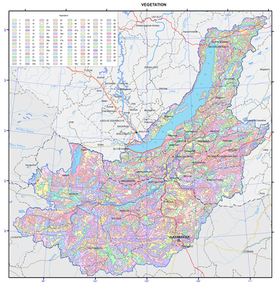
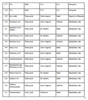
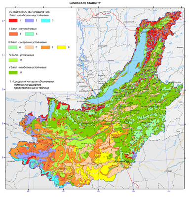
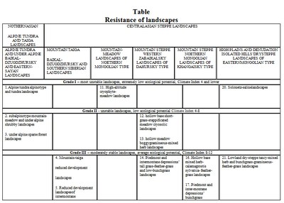
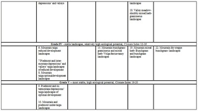
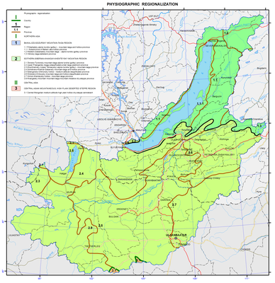
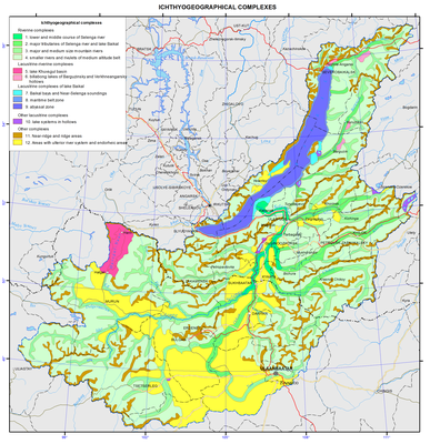
<?xml version="1.0" encoding="utf-8" ?>
<rdf:RDF xmlns:rdf="http://www.w3.org/1999/02/22-rdf-syntax-ns#" xmlns:dc="http://purl.org/dc/elements/1.1/" xmlns:syn="http://purl.org/rss/1.0/modules/syndication/" xmlns="http://purl.org/rss/1.0/">


<channel rdf:about="http://bic.iwlearn.org/search_rss">
  <title>Байкальский информационный центр</title>
  <link>http://bic.iwlearn.org</link>

  <description>
    
            These are the search results for the query, showing results 182 to 196.
        
  </description>


  <image rdf:resource="http://bic.iwlearn.org/logo.png"/>

  <items>
    <rdf:Seq>
      
        <rdf:li rdf:resource="http://bic.iwlearn.org/en/atlas/atlas/45-main-types-of-non-metallic-materials-map/main-types-of-non-metallic-materials-map"/>
      
      
        <rdf:li rdf:resource="http://bic.iwlearn.org/en/atlas/atlas/44-ferrous-nonferrous-rare-and-precious-metal-resources-and-their-extraction-map/ferrous-nonferrous-rare-and-precious-metal-resources-and-their-extraction-map"/>
      
      
        <rdf:li rdf:resource="http://bic.iwlearn.org/en/atlas/atlas/42-landscape-stability-map/landscape-stability-map"/>
      
      
        <rdf:li rdf:resource="http://bic.iwlearn.org/en/atlas/atlas/41-physiographic-regionalization-map/physiographic-regionalization-map"/>
      
      
        <rdf:li rdf:resource="http://bic.iwlearn.org/en/atlas/atlas/40-geosystems-map/geosystems-map"/>
      
      
        <rdf:li rdf:resource="http://bic.iwlearn.org/en/atlas/atlas/39-ichthyogeographical-complexes-map/copy_of_39-ichthyogeographical-complexes-map"/>
      
      
        <rdf:li rdf:resource="http://bic.iwlearn.org/en/atlas/atlas/38-taxonomic-diversity-map/taxonomic-diversity-map"/>
      
      
        <rdf:li rdf:resource="http://bic.iwlearn.org/en/atlas/atlas/33-vegetation-map/vegetation-map"/>
      
      
        <rdf:li rdf:resource="http://bic.iwlearn.org/en/atlas/atlas/32-permafrost-zoning-map/permafrost-zoning-map"/>
      
      
        <rdf:li rdf:resource="http://bic.iwlearn.org/en/atlas/atlas/31-groundwater-map/groundwater-map"/>
      
      
        <rdf:li rdf:resource="http://bic.iwlearn.org/en/atlas/atlas/29-floods-map/floods-map"/>
      
      
        <rdf:li rdf:resource="http://bic.iwlearn.org/en/atlas/atlas/30-surface-water-self-purification-map/surface-water-self-purification-map"/>
      
      
        <rdf:li rdf:resource="http://bic.iwlearn.org/en/atlas/atlas/27-minimum-summer-runoff-map/minimum-summer-runoff-map"/>
      
      
        <rdf:li rdf:resource="http://bic.iwlearn.org/en/atlas/atlas/26-averagelong-termrunoff-map/averagelong-termrunoff-map"/>
      
      
        <rdf:li rdf:resource="http://bic.iwlearn.org/en/atlas/atlas/25-drainage-density-map/drainage-density-map"/>
      
    </rdf:Seq>
  </items>

</channel>


  <item rdf:about="http://bic.iwlearn.org/en/atlas/atlas/45-main-types-of-non-metallic-materials-map/main-types-of-non-metallic-materials-map">
    <title>Main types of nonmetallic materials map</title>
    <link>http://bic.iwlearn.org/en/atlas/atlas/45-main-types-of-non-metallic-materials-map/main-types-of-non-metallic-materials-map</link>
    <description></description>
    <content:encoded xmlns:content="http://purl.org/rss/1.0/modules/content/"><![CDATA[<p><img class="image-inline" src="../../../resolveuid/e609421c005a4d33a8cad29965afb9ce/@@images/image/preview" /></p>
<p><a href="http://bic.iwlearn.org/en/atlas/photos/copy_of__45_Maintypesofnonmetallicmaterials.png" class="internal-link">Open full size</a></p>
<p><img class="image-inline" src="../../../../resolveuid/b1d7d06c2c2f41659de254b9f3dcf0e7/@@images/image/preview" /></p>
<p><a href="http://bic.iwlearn.org/en/photos/copy_of__45_Table_Legend_Maintypesofnonmetallicmaterials.png" class="internal-link">Open full size</a></p>
<p align="center"><strong>The main types of nonmetallic raw materials: resources and development</strong></p>
<p>Nonmetallic mineral resources of the region are of great industrial importance. Within the Baikal basin there are deposits of mining-chemical, thermo-chemical, and optical raw materials, construction materials, mineral fertilizers, ornamental and precious stones.</p>
<p>Deposits of <i>raw quartz </i>belong to strategic types of mineral resources. The region has a large raw materials base explored and prepared for industrial development: there are deposits of especially pure granular quartz (Chulbonskoe, Nadyozhnoe, Goudzhekitskoe, and others) and quartzites (Cheremshanskoe and Goloustenskoe). The vast majority of deposits are located in the territory of Buryatia; there are all prerequisites for creating a large complex of plants for deep processing of raw quartz for high-tech industries. In prospect, the republic can become the largest producer and exporter of polysilicon and total energy systems. Currently, there is a development project of the Chulbonskoe granular quartz deposit in the Severobaikalsky municipal district to get the end-product in the form of photovoltaic systems.</p>
<p>Quartzites of the mined Cheremshanskoe deposit are of exceptionally high raw materials quality meeting industrial requirements for the production of industrial silicon, silicon carbide and ferrosilicon; in recent years, research is carried out on the purest varieties to produce high-purity silicon for  helioenergetics and growing of single crystals of piezoelectric quartz. The deposit has been mined since 1992 by ZAO (Closed Joint Stock Company) “Cheremshansky quartsit” with an annual output of about 200 thousand tons and is a mineral resource base of ZAO (Closed Joint Stock Company) “Kremniy” of the OK (United Company) RUSAL, one of the most cutting edge silicon production facilities in Russia and the country's only producer of refined silicon .</p>
<p>Quartzites of the Goloustenskoe deposit can be used in metallurgy, and in the production of silica bricks. Sources of high-quality abrasive raw materials are microquartzites of two large deposits, located in the Olkhonsky municipal district on the eastern slope of the Baikal Range, namely, Srednekedrovoe and Zavorotninskoe. The latter was developed from 1975 till 1993 by “Baikalkvartssamotsvety”; currently, the deposits are on the governmental standby.</p>
<p>Considerable reserves of raw <i>fluorspar </i>were explored in the Baikal basin in the Republic of Buryatia. Currently, one deposit is mined here. It is the medium Egitinskoe deposit in the Eravninsky district; extracted ore is processed at the ore-dressing plant of the Zabaikalsky mining complex. The Naranskoe deposit in the Selenginsky district was prepared for operation and was mined for some time. The Kyakhtinskaya fluorspar factory operated near the settlement of Khoronkhoy from 1966; first it worked on local raw materials, and then on raw materials imported from Mongolia. Currently, the factory is out of operation.</p>
<p>The region possesses large reserves of chemically pure <i>limestone</i>s: in the Olkhonsky municipal district there is the Ust-Anginskoe deposit, and in the Zaigraevsky district there is the Bilyutinskoe deposit developed for the production of calcium carbide and the Tatarsky Klyuch for the paint and coatings industry. Dolomites of the Tarabukinskoe deposit are used as a raw material for glass and metallurgical production.</p>
<p>Deposits of <i>phosphate</i> raw materials are known in Cisbaikalia. They are the Sarminskoe phosphorite deposit in the Olkhon municipal district and the Slyudyanskoe apatite deposit in the Sludyansky municipal district; in northern Mongolia large reserves of formation phosphorites in the Khovsgol phosphorite basin were discovered and previously explored. The main deposits of the basin are located in the immediate vicinity of Lake Khovsgol, which is an obstacle to their development. The large Oshurkovskoe apatite deposit is prepared for exploitation near the city of Ulan-Ude. On the basis of the approved ready reserves the Zabaikalsky apatite plant was under construction; it was closed down at the building phase of an ore-dressing plant because of possible deterioration of the environmental situation in the Baikal basin. Currently, there is a project of the deposit’s development based on environmentally friendly technologies for the extraction and beneficiation of ores. Taking into account a sustained deficit of phosphate raw materials in the country, an increase of the raw materials base for the production of phosphate fertilizers is a matter of economic security of Russia. The planned standard of production of apatite concentrate is 500 thousand tons per annum. Breakstone will be produced as a by-product in the same amount of 500 thousand tons per annum.</p>
<p>Considering the <i>ceramic and fire-resisting raw materials</i>, deposits of Irkutsk oblast should be pointed out. They are the Naryn-Kuntinskoe microcline pegmatite deposit, developed earlier for the needs of the “Sibfarfor” factory, the Kharginskoe glass sands deposit, on the basis of which the Taltsy plant was established in 1784 producing a variety of glass products for 170 years, and the Asyamovskoe deposit of wollastonite, a relatively new kind of mineral products with a number of unique properties and a growing range of applications. In the south of Buryatia a sillimanite (high-alumina) shales deposit named Chyornaya Sopka is known; its ores have simple mineral composition and are easily dressed. On the basis of the deposit a non-waste production with the release of sillimanite and quartz as commercial products can be created. All the above mentioned deposits are currently on the governmental standby.<i> </i></p>
<p><i>Phlogopite mica</i> deposits in the south of Lake Baikal have been known since the second half of the 18<sup>th</sup> century. Its regular commercial production using a ramified system of underground (tunnels, mines) and open (open pits) mine openings began in 1924 with the development of the electrical engineering industry in the country and lasted until 1973. From four to seven thousand tons of high-quality raw materials were mined annually in the Sludyansky district.<i></i></p>
<p><i>Graphite </i>is represented in the region by two large deposits, namely, the Bezymyannoe (the Slyudyansky municipal district) and Boyarskoe (the Kabansky municipal district) deposits. Ores of the Bezymyannoe deposit are high quality and free-milling according to the manufacturer's tests, but the deposit is located in close proximity to Lake Baikal. The Boyarskoe deposit has the largest reserves. Economic efficiency of its development in compliance with all environmental requirements can be quite high despite low average graphite content in the ore, thanks to its favorable transportation and geographical location.</p>
<p>In the past, a considerable part of the Baikal basin experienced intense volcanic activity, the product of which is <i>pearlite</i> deposits, among which the largest ones are Mukhor-Talinskoe, Zakultinskoe, and Kholinskoe. Currently, this raw material is produced by OAO (Joint Stock Company) “Perlit” on the Mukhor-Talinskoe deposit with the production output amounting to 1-10 thousand m<sup>3</sup> of raw material per annum over the last three years. The Kholinskoe pearlite and zeolite deposit is located on the border of the Republic of Buryatia and Zabaikalsky krai; the mining OOO (Limited Liability Company) “Kholinskie tseolity” develops the deposit. Nowadays, the capacity of the company mining such a valuable kind of mineral product as zeolites is small and amounts to only about 0.8 thousand tons.</p>
<p>Within the region there are a number of deposits of <i>precious and ornamental stones</i>. In Zabaikalsky krai, ZAO (Closed Joint Stock Company) “Turmalkhan” develops a unique deposit of jewelry tourmaline, which is the only one in Russia to date. In the Republic of Buryatia, OOO (Limited Liability Company) “Kaskad” exploits the Khargantinskoe deposit with an annual production of 20 tons of raw jade; ZAO (Closed Joint Stock Company) “MS Holding” started to develop the Khamarkhudinskoe jade deposit, where 510 tons were produced in 2012.</p>
<p>To meet the needs of the construction industry the region possesses significant resources of <i>mineral construction materials</i>: numerous deposits of cement, brick, sand and gravel raw materials, building and facing stone are explored in the area. The raw materials base of the Angarsky cement plant is the large Slyudyanskoe deposit of cement marbles, being developed by the OOO (Limited Liability Company) “Karyer Pereval” with an annual output of about 900 thousand tons. The Tarakanovskoe deposit of cement limestone and Timlyuiskoe deposit of loam supply the Timlyuisky cement plant with raw materials. OOO (Limited Liability Company) “Timlyuitsement” produces 250-400 thousand tons of limestone and 20-35 thousand tons of loam annually.</p>
<p>Facing stone deposits are located on the western and south-eastern shores of Lake Baikal; they are Burovshchina and Novo-Burovshchinskoe deposits of pink marbles and Buguldeiskoe deposit of highly-ornamental statuary marble of various color shades: from snow-white to smoky-gray. Currently, stone is not produced on any of these deposits. Among building stone deposits AO (Joint Stock Company) RZhD exploits two: one of them is the medium Angasolskoe deposit in Irkutsk oblast and the other is the large Zhipkhegenskoe deposit in Zabaikalsky krai forming the raw materials base of the same-name crushed stone plants. Several deposits of building stone are situated in the coastal zone of Lake Baikal, namely, Baikalskoe, Ermolaevskoe, Dinamitnoe and others, rendering their development impossible.</p>
<p>The following deposits of brick and keramzite claysand loams were discovered: the Murinskoe and Khuzhirskoe deposits in Cisbaikalia and Irkaninskoe deposit in the Severobaikalsky municipal district, deposits of sand-gravel mix, including the Utulikskoe deposit of high-quality raw materials, the Pankovskoe deposit of building sands, and so on.</p>
<p>Among <i>other</i> mineral resources of the region, the Zangodinskoe and Kalinishenskoe deposits of mineral paints, Khayanskoe deposit of drilling clays, several deposits of raw materials for stone casting, as well as deposits of mineral salts (sodium sulfate) should be mentioned. All deposits of these raw materials are small in terms of reserves and are on the governmental standby.</p>
<p>In Mongolia small deposits of asbestos, gypsum, graphite, talcum, magnesite, bentonite, ornamental stones (nephrite, serpentinite, lapis lasuli, ophicalcite, chalcedony, etc.), raw quartz, and mineral salts are known within the Baikal basin. As for construction materials there are deposits of building sand, brick, keramzite and ceramic clays, sand-gravel mix, building stone, etc.</p>
<p>The map presents the main nonmetallic mineral raw materials deposits, depending on their size and type of mineral product, as well as mining companies using symbols. The size of the symbol designating a company depends on the average production output over the recent three to five years or on the planned capacity of the objects designed and under construction; gradation is presented in the summary table. The color of the symbol corresponds to the operational phase of an enterprise. The Khubsugulsky phosphorite basin is shown with an areal.</p>
<p>Map construction required the use of the materials of the Regional Funds of Geological Information, maps of mineral resources of the A.P. Karpinsky Russian Geological Research Institute; materials of State Reports “On the Condition of Lake Baikal and Measures of its Protection” for 2010–2012; “National Atlas of the Mongolian People's Republic” (1990), “Atlas of Mongolia” in the Mongolian language (2010), and “Atlas of Socioeconomic Development of Russia” (2009). Information on deposits according to the types of raw materials and on mining companies is presented in the summary table.</p>
<p><img class="image-inline" src="../../../../resolveuid/d284b6f61e4c44f8ad43d46a668322d3/@@images/image/preview" /></p>
<p><a href="http://bic.iwlearn.org/en/photos/45.jpg" class="internal-link">Open full size</a></p>
<p><img class="image-inline" src="../../../../resolveuid/98bbb5cc2eef41158328f7f0eeb57425/@@images/image/preview" /></p>
<p><a href="http://bic.iwlearn.org/en/photos/451.jpg" class="internal-link">Open full size</a></p>
<p><img class="image-inline" src="../../../../resolveuid/a62eb843c052454cb3739df217414e92/@@images/image/preview" /></p>
<p><a href="http://bic.iwlearn.org/en/photos/452.jpg" class="internal-link">Open full size</a></p>
<p><img class="image-inline" src="../../../../resolveuid/6a6a2fd6be0d47ea9f98156bdefaf7d7/@@images/image/preview" /></p>
<p><a href="http://bic.iwlearn.org/en/photos/453.jpg" class="internal-link">Open full size</a></p>
<p><img class="image-inline" src="../../../../resolveuid/ae9af4a5656a4070a90f7207e47a3c60/@@images/image/preview" /></p>
<p><a href="http://bic.iwlearn.org/en/photos/454.jpg" class="internal-link">Open full size</a></p>
<p><img class="image-inline" src="../../../../resolveuid/dd33f181df6e436c924598b054fbd494/@@images/image/preview" /></p>
<p><a href="http://bic.iwlearn.org/en/photos/455.jpg" class="internal-link">Open full size</a></p>
<p><img class="image-inline" src="../../../../resolveuid/17b13986651f47f7bbddb28738053f17/@@images/image/mini" /></p>
<p><a href="http://bic.iwlearn.org/en/photos/456.jpg" class="internal-link">Open full size</a></p>]]></content:encoded>
    <dc:publisher>No publisher</dc:publisher>
    <dc:creator>Alexander Ayurzhanaev</dc:creator>
    <dc:rights></dc:rights>
    <dc:date>2014-10-08T01:50:00Z</dc:date>
    <dc:type>Page</dc:type>
  </item>


  <item rdf:about="http://bic.iwlearn.org/en/atlas/atlas/44-ferrous-nonferrous-rare-and-precious-metal-resources-and-their-extraction-map/ferrous-nonferrous-rare-and-precious-metal-resources-and-their-extraction-map">
    <title>Ferrous, nonferrous, rare and precious metal resources and their extraction map</title>
    <link>http://bic.iwlearn.org/en/atlas/atlas/44-ferrous-nonferrous-rare-and-precious-metal-resources-and-their-extraction-map/ferrous-nonferrous-rare-and-precious-metal-resources-and-their-extraction-map</link>
    <description></description>
    <content:encoded xmlns:content="http://purl.org/rss/1.0/modules/content/"><![CDATA[<p><img class="image-inline" src="../../../resolveuid/c0893da58701459699e0f5004007f3b0/@@images/image/preview" /></p>
<p><a href="http://bic.iwlearn.org/en/atlas/photos/copy_of__44_Ferrousnonferrousrareandpreciousmetalresourcesandtheirextraction.png" class="internal-link">Open full size</a></p>
<p><img class="image-inline" src="../../../../resolveuid/086337cddf4549b08338fd489baddd69/@@images/image/preview" /></p>
<p><a href="http://bic.iwlearn.org/en/photos/copy_of__44_Table.png" class="internal-link">Open full size</a></p>
<p align="center"><strong>Resources of ferrous, nonferrous and rare metals and their mining</strong></p>
<p>Geological exploration exposed over 150 deposits of metallic minerals within the Baikal basin.<b> </b></p>
<p><b>Ferrous metals</b> are represented by a number of iron ore deposits of different genetic types, including two small magnetite deposits, namely, Balbagarskoe in the territory of the Khorinsky municipal district of the Republic of Buryatia and Baleginskoe in the Petrovsk-Zabaikalsky district of Zabaikalsky krai. In the 18<sup>th</sup>-19<sup>th</sup> centuries the Baleginsky mine supplied iron ore to the Petrovsky plant to procure iron and steel for the mines of the Nerchinsky district. In the Olkhonsky municipal district of Irkutsk oblast small iron ore deposits are known; they are mainly represented by brown iron ore deposits (Borsoiskoe, Kuchelginskoe, etc.). In the first half of the 18<sup>th</sup> century, ore from these deposits was used for the needs of the Anginsky (Laninsky) ironworks. The most promising iron ore deposits of Mongolia are the skarn type deposits such as Tumurtolgoy, Bayangol, and Tumurtey, forming the Bayangol iron ore zone in the north of the country. Currently, iron ore deposits in the region are developed only in the territory of Mongolia: small scale extraction of iron ore is underway on the Zakhtsag and Tamir gol deposits; over the recent years, the production on the deposits of the Bayangolskaya iron ore zone amounted to more than five million tons; primary processing is performed at the cleaning plants near the deposits; iron-ore concentrate is exported to China.</p>
<p>The Oldakit manganese deposit, medium in terms of reserves, is located in the Severobaikalsky municipal district less than 30 km from the Baikal-Amur Mainline. Given the fact that Russia is currently experiencing shortage of this raw material, the deposit may be of some interest. Moreover, several small deposits of manganese are known within the boundaries of the Baikal basin, including the Ozerskoe deposit (Olkhonsky district) developed in the 19<sup>th</sup> century for the needs of the Nikolaevsky ironworks.<b></b></p>
<p><b>Nonferrous metals</b>. Almost all reserves and resources of copper ores of the region are concentrated in complex copper-molybdenum and molybdenum-tungsten deposits of Mongolia, located within the Selenginsky volcanoplutonic belt. From 1978 to present a large deposit Erdenetiyn ovoo has been developed; on its basis a joint Soviet-Mongolian venture, the Erdenet Mining Company was established. The plant is engaged in open-pit mining and primary processing of copper-molybdenum ores and is one of the world leaders in the production of copper concentrate. Currently, the production output amounted to more than 25 million tons of ore, while the production of copper concentrate is about 350 thousand tons. In a globalizing world economy, the company faces the challenge of marketability of its products, which necessitates the construction of a copper-smelting plant. At present, the Erdenet Mining Company comprises a pilot plant for the production of pure cathode copper from off-balance and storage ore dump piles of KOO (Limited Liability Company) “Erdmin”, which is a joint venture of Erdenet Mining Company and the American company RCM.</p>
<p>Within the Baikal basin, the largest Kholodninskoe deposit of lead-zinc sulfide ores is explored and prepared for industrial development; its reserves amount to 11.2% of Russia’s total lead reserves and 34.1% of Russia’s total zinc reserves. Based on the economic indicators of development, the deposit is on par with the best world analogues. According to the feasibility study of final mining parameters, the annual production of the underground mine at the deposit should amount to three million tons of ore, 504 thousand tons of zinc concentrate, and 60.3 thousand tons of lead concentrate. In order to ensure environmental safety of production, provision is made for a circulating water supply system, transportation of wastes of the ore-dressing plant outside the catchment area of Lake Baikal using pipelines, and a number of other environmental measures. However, due to the fact that the deposit is located in the Central Ecological Zone of the Baikal Natural Territory (BNT), where mining activity is banned, the production license, owned by the KOO (Limited Liability Company) “InvestEuroCompany” was suspended until 2015. Among other objects of polymetallic raw materials in the region, the medium Davatkinskoe deposit, discovered and assessed in the Khorinsky municipal district of the Republic of Buryatia, should be pointed out.</p>
<p>In Buryatia there are two large deposits of molybdenum ores, namely, Zharchikhinskoe and Malo-Oinogorskoe, and small Pervomaiskoe (abandoned) and Dolon-Modonskoe (undeveloped) deposits. There is a project of the construction of the Pribaikalsky mining and processing plant on the basis of the Zharchikhinskoe deposit, located 40 km to the south of Ulan-Ude in close proximity to the highway and railway, with the molybdenum content in the ore of more than 0.1% and high technological and technical-economic indicators. Its effective development is possible, provided that all necessary environmental requirements are observed.</p>
<p>Tungsten in the region belongs to widespread elements. In the territory of the Zakamensky municipal district there is the Inkurskoe deposit of the stockwork geological-industrial type, which is comparable to the largest similar deposits of the world in terms of its reserves and tungsten content. The Kholtosonskoe deposit, located to the west of the Inkurskoe one, is the largest deposit of the vein type in Russia, and is considered to be unique not only in Russia but also in the world as to its characteristics. The Dzhidinsky tungsten-molybdenum mill operated from 1934 to 1996 on the basis of these two deposits as well as the Pervomaiskoe molybdenum deposit. After the closure of the mill, the tailings pond remained over the area of more than ​​one km<sup>2</sup>, forming the man-made Barun-Narynskoe deposit, the development of which has been started by OAO (Open Joint Stock Company) “Zakamensk” since 2010. A reclamation plant recycling the mill’s waste was built 1.5 km from the town of Zakamensk; the concentrate production amounts to about 300 tons per annum. ZAO (Closed Joint Stock Company) “Tverdosplav” is engaged in the construction of mining sites at the Inkurskoe and Kholtosonskoe deposits. It is planned to build a modern ore-dressing plant and a hydrometallurgical workshop for the processing of tungsten concentrates to produce commercial refined tungsten compounds. In the Petrovsk-Zabaikalsky municipal district of Zabaikalsky krai the prospectors' artel “Kvarts” mines the medium Bom-Gorkhonskoe tungsten deposit by the underground mining method. In recent years, the concentrate production amounted to around 600 tons. The remaining tungsten deposits within the territory of the Russian part of the Baikal basin are temporarily abandoned or are on the governmental standby.</p>
<p>A number of tungsten deposits are known in Mongolia. A small tungsten refinery plant was built on the Tsagaan davaa deposit; the concentrate production amounts to about 40 tons per annum; the final production is exported to the United States and China.</p>
<p>Tin deposits located in the Krasnochikoysky district are small in terms of reserves and are currently mothballed.</p>
<p>In the Dzhidinsky district of Buryatia the medium Borgoiskoe (Al2O3 – 19.8% on average) and Botsinskoe (21.44%) deposits of nepheline-bearing rocks are prospectively explored; currently they remain undeveloped.<b></b></p>
<p><b>Rare metals.</b> In the Kizhinginsky municipal district of the Republic of Buryatia there is the Ermakovskoe deposit of beryllium ores containing 80% of the total beryllium reserves of Russia and unique as to the grade of ore. From 1978 the deposit was developed by the Zabaikalsky mining and processing plant; in 1990 the enterprise was mothballed. Beryllium is a strategic metal essential for the development of nuclear, aerospace, and aviation industry, and instrument engineering; it is used in the manufacture of telecommunications equipment. Currently, Russia’s demand of this metal is met through imports. Whereas it is necessary to restore the raw material and production independence of the country in beryllium, it is expected to resume the production of ore on the deposit, and create production on primary processing of ore, as well as hydrometallurgical production, the end product of which – beryllium hydroxide – will be delivered to the Ulbinsky metallurgical plant in Kazakhstan for processing and producing beryllium alloying compositions and metal. The work to create the beryllium production is included in the Federal Target Program on rare metals of paramount importance.</p>
<p>In the Severobaikalsky municipal district within the Central Ecological Zone of the BNT, three subsoil plots of the Federal importance with large prognostic resources of rare earth elements of the yttrium group are on the governmental standby. They are the Chestenskoe, Akitskoe and Pryamoy-II deposits.<b></b></p>
<p><b>Noble metals. </b>Within the Russian part of the Baikal basin there are no lode gold deposits (except the mined-out Voskresenskoe deposit in the Krasnochikoysky municipal district). Placer gold deposits are small or medium and are grouped into the gold-placer regions, namely: Dzhidinsky, Namaminsky, Yambuy-Tolutaisky, Chikoysky, and Baldzhikansky. In the Republic of Buryatia within the territory under consideration gold practically has not been produced over the recent three years (economically advantageous deposits are mined-out, and exploration and appraisal works require substantial expenditures); in the Krasnochikoysky district of the ​​Zabaikalsky krai, four prospectors' artels produce 300-400 kg of gold annually using the open-pit hydromechanical method.</p>
<p>Gold is the second most significant mineral resource of Mongolia after copper. The industrial mining of gold ores in the country was launched in the early 20<sup>th</sup> century by the Russian-Mongolian joint-stock company “Mongolor” in the Iro-Gol river basin, in the Khovsgol region and in the Boroo area. Primary deposits are usually of the vein type, more rarely – mineralized zones. The most significant primary deposits in terms of reserves include the Boroo deposit in the Boroo-Zuunmod region and the Bumbat deposit in the Zaamarsky gold field. The metal content in individual layers reaches 10 g/t. The deposits are developed by Canadians with the annual production of five and 1.5 tons of metal, respectively. Moreover, gold is currently mined on the Narantolgoy and Nariyn gol deposits.</p>
<p>Among the placers small and medium ones predominate, and only single ones are large placers in terms of reserves. Most placers are shallow single-layer, rarely double-layer; in rare cases deep placers occur. Dredging and separate production techniques are applied at the placer deposits. After mining by large companies, the remaining gold is mined by individual prospectors, whose number exceeded 10 thousand people according to the official data alone. In river valleys, where mining is possible, huge settlements are formed. As a result, in recent years the country faced an intensive shallowing and pollution of rivers, shrinking of grazing lands for cattle, and a process of desertification of the southern territory, and drinking water shortages for population occur. This is largely due to huge volumes of gold mining in the river valleys, illegal use of mercury and cyanides, and almost total lack of reclamation.</p>
<p>The map symbols show metallic mineral deposits depending on their size and type of commercial minerals. Mining companies are also shown with symbols. The size of a symbol corresponds to the production output. The group of large companies include ferrous, nonferrous and rare metals producing enterprises with production ranging from 1 to 10 million tons of ore per annum, the group of medium ones comprises the production output of 0.1-1 million tons per annum,</p>
<p><img class="image-inline" src="../../../../resolveuid/b5bd74556d5045bcac18238e545cd3c4/@@images/image/preview" /></p>
<p><a href="http://bic.iwlearn.org/en/photos/44.jpg" class="internal-link">Open full size</a></p>
<p><img src="http://bic.iwlearn.org/en/photos/441.jpg/@@images/9854ac0a-f6fc-46c7-b910-b40a35514466.jpeg" alt="" class="image-inline" title="" /></p>
<p><a href="http://bic.iwlearn.org/en/photos/441.jpg" class="internal-link">Open full size</a></p>
<p>and small ones produce less than 0.1 million tons per annum. The Erdenet Mining Company is highlighted as a very large enterprise with an annual production of more than 20 million tons. The following gradation is accepted for gold mining: large companies are gold mines with the production of more than one ton per annum, medium companies are those producing 0.1-1 ton, and small ones are those with less than 0.1 tons produced. The color of the symbol corresponds to the exploitation phase of an enterprise: operating or projected and under construction; additional outline corresponds to the underground mining method. Gold-placer regions of the given territory are depicted by areals.</p>
<p>Table 1</p>
<p><img class="image-inline" src="../../../../resolveuid/f4a37e81d4d7431fbf95f7265a1b458e/@@images/image/preview" /></p>
<p><a href="http://bic.iwlearn.org/en/photos/442.jpg" class="internal-link">Open full size</a></p>
<p><img class="image-inline" src="../../../../resolveuid/1441b8be04934550bc0ebb4c83b9c44e/@@images/image/preview" /></p>
<p><a href="http://bic.iwlearn.org/en/photos/443.jpg" class="internal-link">Open full size</a></p>
<p><img class="image-inline" src="../../../../resolveuid/98c96c25632e4b9dba75b2fc82411706/@@images/image/preview" /></p>
<p><a href="http://bic.iwlearn.org/en/photos/444.jpg" class="internal-link">Open full size</a></p>
<p><img class="image-inline" src="../../../../resolveuid/1daaaef9f0114fa981b1592254b6aace/@@images/image/preview" /></p>
<p><a href="http://bic.iwlearn.org/en/photos/445.jpg" class="internal-link">Open full size</a></p>
<p><img class="image-inline" src="../../../../resolveuid/447e28e1422745858950a3147aee5e36/@@images/image/preview" /></p>
<p><a href="http://bic.iwlearn.org/en/photos/446.jpg" class="internal-link">Open full size</a></p>
<p><img class="image-inline" src="../../../../resolveuid/27ce7f6bf2034632ac0fd4ae1948ce81/@@images/image/mini" /></p>
<p><a href="http://bic.iwlearn.org/en/photos/447.jpg" class="internal-link">Open full size</a></p>]]></content:encoded>
    <dc:publisher>No publisher</dc:publisher>
    <dc:creator>Alexander Ayurzhanaev</dc:creator>
    <dc:rights></dc:rights>
    <dc:date>2014-10-08T01:20:00Z</dc:date>
    <dc:type>Page</dc:type>
  </item>


  <item rdf:about="http://bic.iwlearn.org/en/atlas/atlas/42-landscape-stability-map/landscape-stability-map">
    <title>Landscape stability map</title>
    <link>http://bic.iwlearn.org/en/atlas/atlas/42-landscape-stability-map/landscape-stability-map</link>
    <description></description>
    <content:encoded xmlns:content="http://purl.org/rss/1.0/modules/content/"><![CDATA[<p><img class="image-inline" src="../../../../resolveuid/def380b90f9b43e4b12b647035d988e2/@@images/image/preview" /></p>
<p><a href="http://bic.iwlearn.org/en/photos/copy2_of__42_LandscapeStability.png" class="internal-link">Open full size</a></p>
<p><img class="image-inline" src="../../../../resolveuid/145d45f9d03741aa8547a78a340e3803/@@images/image/preview" /></p>
<p><img class="image-inline" src="../../../../resolveuid/e1c273139cad4e6d90a1922fc5d06091/@@images/image/preview" /></p>
<p align="center"><strong>Landscapes stability </strong></p>
<p align="center"><strong> </strong></p>
<p>Landscape stability is one of the most important parameters determining the state of the environment and changes occurring in it under the influence of natural and anthropogenic factors. The nature of landscape changes depends on the location in the geographical environment, their properties, and type and extent of the anthropogenic impact. Of particular importance is the estimation of landscapes stability of the Baikal basin, which is an environmentally critical area.</p>
<p>Landscape stability is a property of a geosystem to maintain its structure and the mode of functioning under changing conditions of its environment [Protection of landscapes..., 1982]. An assessment and mapping of landscapes stability are made according to the complex of natural and anthropogenic factors of influence. The natural factor is mainly determined by the influence of climate (indicators of heat-moisture supply) and the properties of lithological-and-geomorphological basis. The anthropogenic influencing factor is associated with the background nature management, which is based on spatially extensive use of natural resources, and lands, closely related to the zonal-belt features of natural landscapes. The background types of nature management in the study area include agriculture, mainly in steppe landscapes, forestry in taiga landscapes, as well as recreation.</p>
<p>Stability is considered in relation to landscapes of two levels: regional (geoms) and topological (groups of facies). A landscape map, compiled by the authors on the basis of landscape maps of the territory under consideration [Landscapes..., 1977; Landscapes..., 1990], was used for its mapping.</p>
<p>Stability of landscapes of the regional level – geoms – is determined based on the level of natural ecological potential of a landscape (EPL), the main indicator of which is the index of biological effectiveness of climate (TK) according to N.N. Ivanov [Ecological..., 2007, Ecological..., 2007]. Characterization and comparative assessment of this indicator is based on the ratio of heat and moisture, on which the biological productivity of a landscape and ecological capacity primarily depend. At the same time, the influence of latitudinal and altitudinal zonality on their distribution is traced. A single and continuous process of moisture and heat exchange not only forms the spatial differentiation and a type of a landscape, but also determines its stability. Landscapes with high values of TK and EPL are the most stable, while low values ​​of these parameters characterize unstable landscapes.</p>
<p>Twenty-two geoms are represented in the landscape structure of the territory under consideration. Mountain terrain predominates in the catchment area of ​​Lake Baikal. Therefore, this territory is characterized by the altitudinal belt differentiation of landscapes, which determines the degree of their stability.</p>
<p>At the regional level, according to the values ​​of these indicators, landscapes are subdivided into five ecological groups of geoms, to which the corresponding values ​​of stability, ranged on a five-point scale, are assigned. These values ​​are considered as the starting point, or background stability.</p>
<p>A geom unites groups of facies similar in structural-dynamic characteristics [Sochava, 1978]. This taxonomic unit is important in generalization of geotopological works. Inside a geom, stability was readjusted in respect of groups of facies with different dynamic categories. A set of variable states of these categories includes indigenous, pseudo-indigenous, serial and derivative geosystems under one epifacie. The highest natural and anthropogenic stability characterizes indigenous landscapes with well-established intrasystemic and external relations; many of them are notable for durability. Pseudo-indigenous landscapes, unlike indigenous ones, are modified as a result of hypertrophy of one of the components of the system. Serial facies in most cases are nondurable, quickly alternating with each other spontaneous geosystems, formed under the significant hypertrophy influence of various natural factors. In a range of transformation of geosystems they are characterized by the greatest variability and are prone to damage, and therefore they are classified as landscapes unstable to anthropogenic impacts. Derivative landscapes are variable states of geosystems caused by human influence. They are characterized by different degrees of stability.</p>
<p>The highest values ​​of stability, considered as the initial point corresponding to the background rate of stability of a geom, are set for indigenous facies. Further on, the initial point is reduced to three gradations, namely, for pseudo-indigenous, serial and derivative facies. For pseudo-indigenous facies a decrease in the stability by 1 point in relation to the initial point is possible; for serial facies it can amount to 1-2 points. For derivative facies deviations from the norm can reach 1-2 points towards an increase or decrease in the stability depending on the type of succession, namely, progressive stabilizing or digressive destabilizing.</p>
<p>To assess the anthropogenic stability of landscapes an analysis was made of disturbances of natural environment, arising under the influence of various types of human activities related to the background land use. According to the predominant nature of the background land use, the following types of functional load on the environment were distinguished: agricultural arable and grazing (mainly for steppe and forest-steppe landscapes), and forestry (for taiga landscapes) and recreation.</p>
<p>Stability of arable lands was largely determined by the intensity of erosion loss, soil deflation and pesticide pollution, and natural self-purification potential of soils. Stability of natural-forage lands was determined in respect of plant communities to grazing and haymaking and was assessed according to the degree of degradation of hayfields and pastures, susceptibility to erosion and deflation, and recoverability of vegetation and soils.</p>
<p>The most significant impact on the state of forests is made by commercial logging using the clear felling approach. Stability of forest landscapes was determined according to the degree of disturbance of forests by felling and fires, recreation, and agricultural use. Reforestation is influenced by changing temperature conditions, hydrophysical properties of soils, evolving erosion and cryogenic processes, deflation and waterlogging in felled and burnt areas. An important criterion for stability, i.e. forest bonitet, is an indicator of productivity and environmental growth conditions, evaluated by richness (trophicity) and moisture content of soil. Environmental factors, spontaneous and associated with the human activity, prevent natural reforestation; their progressive successions do not reach the original state. Such landscapes fall in the category of the most unstable.</p>
<p>Recreational stability is assessed referring to the mass recreation and tourist-excursion activities. Indicators of the degree of recreational digression of landscapes, depending on the type and intensity of recreational influence, sensitivity and recoverability of landscapes, which together define their recreational potential, served as stability criteria. Stability of landscapes is a key indicator, based on which the regulation of recreational loads is made.</p>
<p>The compiled map reflects the territorial diversity of landscape stability, characteristics of which is presented in the table.</p>
<p>The lowest and low (I-II points) stability characterize goletz and sub-goletz landscapes presented in major mountain ranges in the north-eastern and south-western parts of the territory. In the north-east, they are goletz and sub-goletz landscapes of the Baikalsky, Verkhne-Angarsky, Barguzinsky, and Ikatsky ridges in the framing of the Severo-Baikalskaya, Verkhne-Angarskaya and Barguzinskaya depressions. In the Khovsgol region and in Southern Cisbaikalia they include the Eastern Sayan mountain structures. In the south-west, alpine meadows, and subalpinotype and subgoletz landscapes of the Khangai and Khentei uplands are characterized by low stability.</p>
<p>Ecological potential of these landscapes is very low; TK is less than 8. The structure of geoms is dominated by serial groups of facies. They are characterized by severe climatic conditions and dissected mountainous terrain, active development of exogenous geological processes, and lack of heat and excess of moisture. The same values ​​of stability are assigned to steppe landscapes of depressions and valley bottoms, characterized by the excess of heat together with the lack of moisture, with manifestations of cryomorphism, waterlogging, water erosion and deflation, and soil salinization.</p>
<p>In general, the Baikal basin is dominated by moderately stable and stable landscapes (III-IV points), distributed mainly in the central part of the territory. They are characterized by medium and relatively high ecological potential; the index of biological effectiveness of climate amounts to 8-16. Pseudo-indigenous geosystems with a relatively stable landscape structure predominate.</p>
<p>Landscapes of reduced development of mountain-taiga and taiga intermountain depressions and valleys, having dispersed distributional pattern and occurring in the Selenga-Vitim interfluve and to the north of the Khangai upland, are referred to the stability of III points.</p>
<p>The stability of III points also characterizes piedmont and plain relatively dry and arid steppes. They are located in the Barguzinskaya depression, in hollows of the Trans-Baikal type, to the north of the Khangai upland, and in the surroundings of the Khentei upland.</p>
<p>The group of geoms with the stability of IV points includes mountain-taiga landscapes of restrictive and optimal development, taiga piedmont landscapes of intermontane depressions and valleys of restrictive development, mountain low-bunchgrass and forbs-bunchgrass, and mountain dry steppes. The main areas of development of taiga landscapes of this stability group are low- and middle mountains to the south of the Eastern Sayan, the Primorsky ridge, Selenginskoe middle mountains, Vitimskoe plateau, Olekminsky Stanovik, Khentei-Chikoy upland, and others. Mountain steppes with IV points of stability are most commonly found in the Selenge-Orkhon interfluve.</p>
<p>Landscapes with the highest ecological potential for the region, and TK amounting to 16-20, are classified as the most stable (V points). In the Russian part of the territory, they are landscapes of piedmont and intermountain depressions of optimal development, as well as piedmont subtaiga landscapes. They are found in the Verkhne-Angarskaya and Barguzinskaya depressions, in the Selenga river delta, and in depressions of the Trans-Baikal type. In Mongolia they are represented by mountain subtaiga landscapes, the large area of which is middle and low mountains lying to the north of the Khangai upland in the central part of the basin of the Selenge and Orkhon rivers. The structure of geoms is dominated by pseudo-indigenous and indigenous geosystems. They are the nuclei of the ecological stability and reproduction of the environment [Mikheev, 2001]. In the landscape structure of the region their distribution area is in the transition zone between taiga and steppe landscapes with low background stability.</p>
<p>The conducted mapping of landscape stability is the basis for the assessment of the anthropogenic impact on the environment, and for substantiation of environmentally acceptable nature management in the Baikal basin.</p>
<p><b> </b></p>
<p align="center">References</p>
<p>Landscapes of the south of Eastern Siberia (map, scale 1:1500000). (1977). V.S. Mikheev and V.A. Ryashin. Moscow: GUGK, , 4 sheets.</p>
<p>Landscapes (map, scale 1:3000000) (1990). in <i>National Atlas. Mongolian People's Republic. </i>Ulaanbaatar–Moscow, pp. 83-85.</p>
<p>Mikheev, V.S. (2001). <i>Landscape synthesis of geographic knowledge.</i> Novosibirsk: Nauka, 216 p.</p>
<p><i>Protection of Landscapes. Explanatory Dictionary.</i> (1982). Moscow: Progress, 272 p.</p>
<p>Sochava, V.B. (1978). Introduction to the Theory of Geosystems. Novosibirsk: Nauka, 320 p.</p>
<p>Ecological potential of landscapes (map, scale 1:15000000). (2007). In <i>National Atlas of Russia.</i> Vol 2: Nature and Ecology. Moscow: PKO “Kartografiya”, p. 417.</p>
<p>Ecologo-geographical map (scale 1:15000000). (2007). In <i>National Atlas of Russia.</i> Vol. 2: Nature and Ecology. Moscow: PKO “Kartografiya”, pp. 454-456.</p>]]></content:encoded>
    <dc:publisher>No publisher</dc:publisher>
    <dc:creator>Alexander Ayurzhanaev</dc:creator>
    <dc:rights></dc:rights>
    <dc:date>2014-10-08T01:10:00Z</dc:date>
    <dc:type>Page</dc:type>
  </item>


  <item rdf:about="http://bic.iwlearn.org/en/atlas/atlas/41-physiographic-regionalization-map/physiographic-regionalization-map">
    <title>Physiographic regionalization map</title>
    <link>http://bic.iwlearn.org/en/atlas/atlas/41-physiographic-regionalization-map/physiographic-regionalization-map</link>
    <description></description>
    <content:encoded xmlns:content="http://purl.org/rss/1.0/modules/content/"><![CDATA[<p><img class="image-inline" src="../../../resolveuid/355a4a1876c542bcad6afa5d32ae02a3/@@images/image/preview" /></p>
<p><a href="http://bic.iwlearn.org/en/atlas/photos/copy_of__41_Physiographicregionalization.png" class="internal-link">Open full size</a></p>
<p align="center" class="1CxSpFirst"><b>Physical-geographical regionalization </b></p>
<p align="center" class="1CxSpMiddle"><b>and the landscape-typological structure (40-41)</b><b> </b></p>
<p align="center" class="1CxSpMiddle"><b> </b></p>
<p class="1CxSpMiddle">The materials presented uniformly consider physical-geographical regionalization and the landscape-typological structure of the Baikal basin. Map compilation was based on the idea of geosystems classification and the resultant works, including cartographic works on physical-geographical differentiation of the territory in the Russian Federation and Mongolia, which are presented below.</p>
<p class="1CxSpMiddle">The boundaries of physical-geographical structures (individual and typological) were integrally positioned on the same topographic base in the Mapinfo environment and verified according to the Landsat 7 multispectral satellite images (2000).</p>
<p class="1CxSpMiddle">The physical-geographical regionalization map reflects individual heterogeneous regional natural formations. The featured physical-geographical regions and provinces characterize the territories with a similar geographical location, manifestation of morphotectonic geological and geomorphological features, latitudinal, vertical and bioclimatic zonation. Physical-geographical regions, countries and provinces are comparable across different research. Mountain areas of North Asian mountain megalocation on the edge sphere of the continent (Baikal-Dzhugdzhurskaya and South-Siberian-Khangai-Khentei) and their contact with the Central Asian desert-steppe region of the Central continental megalocation are presented within this territory. Intraregional differentiation into provinces is related to the specific manifestations of altitudinal differences and geological and geomorphological features in mosaics of geosystem types and their mobile components of soils and vegetation. The map shows three physical-geographical areas and 12 provinces.</p>
<p class="1CxSpMiddle">Landscape-typological structure shows the features of spatial mosaic of individual physical-geographical units, their internal structure of relatively homogeneous combinations of physical-geographical conditions. In accordance with the small scale, 39 geom groups are shown on the map. The geoms are distinguished according to the indicators of topological order, but generalized to the regional level [Sochava, 1978]. They combine topogeosystems of the certain zone or belt (within a physical-geographical region) characterized by similar structural features of soil cover, vegetation and hydrothermal regime. The vegetational component of a geom is adequate to a formation, soil one is close to the subtype of soils, and the climate regime is close to the modification of climate of a subzone, which arose under the influence of the structural properties of other components.</p>
<p class="1CxSpMiddle">Geosystems specific to North and Central Asia form the regional classification range. Their location, interpenetration and uniqueness of landscape situations in the Baikal basin are presented. Regional interpretation of landscape-typological units (geom groups on the geasystem map) characterizes their latitudinal and altitudinal differences, as well as shows their relation to various regional and typological complexes of natural conditions that may be disclosed in detail on a larger display scale of landscape structures and geosystem components.</p>
<p class="1CxSpMiddle">Multiscale mosaic character of the natural-territorial structure determines the landscape complexity of the territory, the local "contrasts" of economic use, and specificity of different local options of development.</p>
<p class="1CxSpMiddle"><b> </b></p>
<p align="center" class="1CxSpMiddle">References</p>
<p class="1CxSpMiddle">Sochava, V.B. (1978). <i>Introduction to the Theory of Geosystems.</i> Novosibirsk: Nauka . Sib. Otd., 320 p.</p>
<p class="1CxSpMiddle">Sochava, V.B. and Timofeev, D.A. (1968). Physical-geographical regions of North Asia. In: <i>Reports of the Institute of Geography of Siberia and the Far East</i>, vol. 19, pp. 3-19.</p>
<p class="1CxSpMiddle">Preobrazhensky, V.S., Fadeev, N.V., Mukhina, L.I., and Tomilov, G.M. (1959). Types of locality and natural zoning of the Buryat ASSR. Moscow: Izd-vo AN SSSR, 219 p.</p>
<p class="1CxSpMiddle">Landscapes of the south of Eastern Siberia. 1:1500000 Map; Physical-geographical regionalization. 1:8 000 000 Map. (1977). Mikheev, V.S., Ryashin, V.A. with the participation of Bogoyavlenskaya, N.G., Vetrova, S.D., Dmitrienko, L.S., Zhitlukhina, T.I., Kosmakova, O.P., Krotova, V.M., Smirnova, D.A. Ed. by V.B. Sochava. Moscow: GUGK, 1977.</p>
<p class="1CxSpMiddle">Mikheev, V.S. (1990). Physical-geographical regionalization. In: <i>Nature and environment protection in the Baikal watershed basin.</i> Novosibirsk: Nauka. Sib. Otd., pp. 21-29.</p>
<p class="1CxSpMiddle">Mikheev, V.S. and Ryashin, V.A. (1967). Landscapes; Physical-geographical regionalization. In: <i>Atlas of Transbaikalia</i>. Moscow-Irkutsk: GUGK, pp.70-71, p. 76, text pp.172-173.</p>
<p class="1CxSpMiddle">Batjargal, B., Mikheev, V.S., and Erdenechimeg, Zh. (1989). Landscapes (map 39, text p.103). Physical-geographical regionalization (map 45, text p.104). In: <i>Atlas of Lake Khovsgol.</i> Moscow: GUGK.</p>
<p class="1CxSpLast">Fadeeva, N.V., Smirnova, E.V., and Tulgaa, Kh. (1989). Landscapes and natural zoning in the atlas of the MPR. In: <i>The National Atlas of the Mongolian People's Republic (problematic and scientific content).</i> Novosibirsk: Nauka. Sib. Otd., pp. 109-125.</p>
<p>Dash, D., Smirnova, E.L., Tulgaa, Kh., and Fadeeva, N.V. (1990). Landscapes and natural zoning. Maps 145, 146 (scale 1:3 000 000) text p. 83. In: <i>The National Atlas of the MPR.</i> GUGK SSSR, GUGK MPR.</p>]]></content:encoded>
    <dc:publisher>No publisher</dc:publisher>
    <dc:creator>Alexander Ayurzhanaev</dc:creator>
    <dc:rights></dc:rights>
    <dc:date>2014-10-08T01:05:00Z</dc:date>
    <dc:type>Page</dc:type>
  </item>


  <item rdf:about="http://bic.iwlearn.org/en/atlas/atlas/40-geosystems-map/geosystems-map">
    <title>Geosystems map</title>
    <link>http://bic.iwlearn.org/en/atlas/atlas/40-geosystems-map/geosystems-map</link>
    <description></description>
    <content:encoded xmlns:content="http://purl.org/rss/1.0/modules/content/"><![CDATA[<p><img class="image-inline" src="../../../resolveuid/9a56821a06e54383a94740636f8c0c85/@@images/image/preview" /></p>
<p><a href="http://bic.iwlearn.org/en/atlas/photos/copy_of__40_Geosystems.png" class="internal-link">Open full size</a></p>
<p class="1" style="text-align: center; "><b>Physical-geographical regionalization </b></p>
<p style="text-align: center; "><b>and the landscape-typological structure</b></p>
<p align="center" class="1CxSpMiddle"><strong> </strong></p>
<p class="1CxSpFirst">The materials presented uniformly consider physical-geographical regionalization and the landscape-typological structure of the Baikal basin. Map compilation was based on the idea of geosystems classification and the resultant works, including cartographic works on physical-geographical differentiation of the territory in the Russian Federation and Mongolia, which are presented below.</p>
<p class="1CxSpMiddle">The boundaries of physical-geographical structures (individual and typological) were integrally positioned on the same topographic base in the Mapinfo environment and verified according to the Landsat 7 multispectral satellite images (2000).</p>
<p class="1CxSpMiddle">The physical-geographical regionalization map reflects individual heterogeneous regional natural formations. The featured physical-geographical regions and provinces characterize the territories with a similar geographical location, manifestation of morphotectonic geological and geomorphological features, latitudinal, vertical and bioclimatic zonation. Physical-geographical regions, countries and provinces are comparable across different research. Mountain areas of North Asian mountain megalocation on the edge sphere of the continent (Baikal-Dzhugdzhurskaya and South-Siberian-Khangai-Khentei) and their contact with the Central Asian desert-steppe region of the Central continental megalocation are presented within this territory. Intraregional differentiation into provinces is related to the specific manifestations of altitudinal differences and geological and geomorphological features in mosaics of geosystem types and their mobile components of soils and vegetation. The map shows three physical-geographical areas and 12 provinces.</p>
<p class="1CxSpMiddle">Landscape-typological structure shows the features of spatial mosaic of individual physical-geographical units, their internal structure of relatively homogeneous combinations of physical-geographical conditions. In accordance with the small scale, 39 geom groups are shown on the map. The geoms are distinguished according to the indicators of topological order, but generalized to the regional level [Sochava, 1978]. They combine topogeosystems of the certain zone or belt (within a physical-geographical region) characterized by similar structural features of soil cover, vegetation and hydrothermal regime. The vegetational component of a geom is adequate to a formation, soil one is close to the subtype of soils, and the climate regime is close to the modification of climate of a subzone, which arose under the influence of the structural properties of other components.</p>
<p class="1CxSpMiddle">Geosystems specific to North and Central Asia form the regional classification range. Their location, interpenetration and uniqueness of landscape situations in the Baikal basin are presented. Regional interpretation of landscape-typological units (geom groups on the geasystem map) characterizes their latitudinal and altitudinal differences, as well as shows their relation to various regional and typological complexes of natural conditions that may be disclosed in detail on a larger display scale of landscape structures and geosystem components.</p>
<p class="1CxSpMiddle">Multiscale mosaic character of the natural-territorial structure determines the landscape complexity of the territory, the local "contrasts" of economic use, and specificity of different local options of development.</p>
<p class="1CxSpMiddle"><b> </b></p>
<p align="center" class="1CxSpMiddle">References</p>
<p class="1CxSpMiddle">Sochava, V.B. (1978). <i>Introduction to the Theory of Geosystems.</i> Novosibirsk: Nauka . Sib. Otd., 320 p.</p>
<p class="1CxSpMiddle">Sochava, V.B. and Timofeev, D.A. (1968). Physical-geographical regions of North Asia. In: <i>Reports of the Institute of Geography of Siberia and the Far East</i>, vol. 19, pp. 3-19.</p>
<p class="1CxSpMiddle">Preobrazhensky, V.S., Fadeev, N.V., Mukhina, L.I., and Tomilov, G.M. (1959). Types of locality and natural zoning of the Buryat ASSR. Moscow: Izd-vo AN SSSR, 219 p.</p>
<p class="1CxSpMiddle">Landscapes of the south of Eastern Siberia. 1:1500000 Map; Physical-geographical regionalization. 1:8 000 000 Map. (1977). Mikheev, V.S., Ryashin, V.A. with the participation of Bogoyavlenskaya, N.G., Vetrova, S.D., Dmitrienko, L.S., Zhitlukhina, T.I., Kosmakova, O.P., Krotova, V.M., Smirnova, D.A. Ed. by V.B. Sochava. Moscow: GUGK, 1977.</p>
<p class="1CxSpMiddle">Mikheev, V.S. (1990). Physical-geographical regionalization. In: <i>Nature and environment protection in the Baikal watershed basin.</i> Novosibirsk: Nauka. Sib. Otd., pp. 21-29.</p>
<p class="1CxSpMiddle">Mikheev, V.S. and Ryashin, V.A. (1967). Landscapes; Physical-geographical regionalization. In: <i>Atlas of Transbaikalia</i>. Moscow-Irkutsk: GUGK, pp.70-71, p. 76, text pp.172-173.</p>
<p class="1CxSpMiddle">Batjargal, B., Mikheev, V.S., and Erdenechimeg, Zh. (1989). Landscapes (map 39, text p.103). Physical-geographical regionalization (map 45, text p.104). In: <i>Atlas of Lake Khovsgol.</i> Moscow: GUGK.</p>
<p class="1CxSpLast">Fadeeva, N.V., Smirnova, E.V., and Tulgaa, Kh. (1989). Landscapes and natural zoning in the atlas of the MPR. In: <i>The National Atlas of the Mongolian People's Republic (problematic and scientific content).</i> Novosibirsk: Nauka. Sib. Otd., pp. 109-125.</p>
<p>Dash, D., Smirnova, E.L., Tulgaa, Kh., and Fadeeva, N.V. (1990). Landscapes and natural zoning. Maps 145, 146 (scale 1:3 000 000) text p. 83. In: <i>The National Atlas of the MPR.</i> GUGK SSSR, GUGK MPR.</p>]]></content:encoded>
    <dc:publisher>No publisher</dc:publisher>
    <dc:creator>Alexander Ayurzhanaev</dc:creator>
    <dc:rights></dc:rights>
    <dc:date>2014-10-07T08:30:00Z</dc:date>
    <dc:type>Page</dc:type>
  </item>


  <item rdf:about="http://bic.iwlearn.org/en/atlas/atlas/39-ichthyogeographical-complexes-map/copy_of_39-ichthyogeographical-complexes-map">
    <title>Ichthyogeographical complexes map</title>
    <link>http://bic.iwlearn.org/en/atlas/atlas/39-ichthyogeographical-complexes-map/copy_of_39-ichthyogeographical-complexes-map</link>
    <description></description>
    <content:encoded xmlns:content="http://purl.org/rss/1.0/modules/content/"><![CDATA[<p><img class="image-inline" src="../../../resolveuid/acd3243c328b4c9ca4539d059f86f98c/@@images/image/preview" /></p>
<p><a href="http://bic.iwlearn.org/en/atlas/photos/copy_of__39_Ichthyogeographicalcomplexes.png" class="internal-link">Open full size</a></p>
<p><img class="image-inline" src="../../../../resolveuid/31da5e677e8a4d79aa1a55fc5df80b33/@@images/image/preview" /></p>
<p><a href="http://bic.iwlearn.org/en/photos/copy_of__39_Legend_Ichthyogeographicalcomplexes_1.png" class="internal-link">Open full size</a></p>
<p><img class="image-inline" src="../../../../resolveuid/fb8d6de2d349468384bdac4d232e13c5/@@images/image/preview" /></p>
<p><a href="http://bic.iwlearn.org/en/photos/copy_of__39_Legend_Ichthyogeographicalcomplexes_2.png" class="internal-link">Open full size</a></p>
<p class="a0" style="text-align: center; "><strong>Ichthyofauna</strong></p>
<p>Ichthyofauna of Lake Baikal and its basin comprises 67 species and subspecies including 6 naturalized ones. Within the bounds of the lake 57 species and subspecies are registered. Out of this number 34 are endemic golomyanka-goby fishes (Cottoidei) (Table) [The freshwater fish atlas…, 2003; Fishes of…, 2007; Fishes of the Mongolian…, 1983; Sideleva, 2003]. A certain conventionality in the assessment of the fish population composition according to species and subspecies should be highlighted. In terms of biodiversity such accounting is to an extent justified, but such characterization is insufficient for the assessment of ecosystem’s operation. For instance, omul which occupies a 350-meter water column comprises 3 morphoecological fish groups with various morphological diagnoses, behavior, rates of growth, deposition of fat and breeding grounds. The same can be noted in the case of cisco (3 morphogroups) and black and white graylings.  These are young “endemic” forms. Their age is within the limits of the Holocene, but they are new stable structural-functional formations “in the bioenergetic sense equivalent” to species [Reshetnikov, 1980]. With them considered the total fish composition of the basin increases to 71, and 61 in Lake Baikal. The results of immigration of various fish species in Lake Baikal for naturalization carried out in the 20<sup>th</sup> century testify to the fact that zones of life in the lake and its food supplies are quite rigidly fixed. Out of 33 species and intraspecific forms tested for immigration only the Amur carp, catfish, sleeper and Caspian bream survived in the lake (mostly in its “peripheries”), while peled survived in the lakes of the watershed basin. Rejection of non-Baikal fish species by Lake Baikal was also reflected in the analysis of the causes of “unmixing” of the Baikal fauna with the life around the lake.</p>
<p class="a1">According to current concepts [Vereshchagin, 1935; Kozhov, 1962; Taliev, 1955, etc.], Baikal’s ichthyofauna is divided into two ecologically and genetically diverse complexes: European-Siberian and native Baikal ones. In the recent years the “neoendemics” or new young endemic offshoots of widely spread species have been registered [Timoshkin, 1995].</p>
<p class="a1">The faunal classification by G.V. Nikol’sky (1953, 1980) is usually used in the course of analysis of fish distribution according to their biotope [Kozhov, 1960]. Despite some shortcomings [Sychevskaya, 1983] this classification is rather appropriate for reflecting the ecological specificities of the faunal complexes in the conditions of one and the same water body. It enables to observe their rigid differentiation in Lake Baikal [Mamontov, 1977; Sorokin, Sorokina, 1988].</p>
<p class="a1">The ichthyogeographic complexes</p>
<p class="a1"><i>Lake Baikal</i></p>
<p class="a1">1. System of lakes, sors, bays and near-delta shallow waters of Lake Baikal. Inhabits the boreal plain complex – limnophiles of the coastal-sor fish group (roach, perch, pike, orfe, crucian carp, etc.) occupy the entire system of interconnected lakes, bays and sors of Lake Baikal to a depth of 10-50 m. Sturgeon is the only exception for particular distribution to depths of 180 m. In Baikal it occupies an area of limnorheophiles. The lakes near Lake Baikal (Kotokel’, Dukhovoe, and Barmashovoe) can also be included here. Their ichthyofauna composition and productivity are dependent on a degree of their connection with Lake Baikal. The highest productivity occurs with the maximum, but not complete, disjunction with Baikal. Lake Kotokel’, one of the most productive lakes, is inhabited by 15 fish species (catfish, carp, bream, roach-bream hybrid, roach, dace, nerfling, crucian carp, river perch, sand sculpin, and stoneloach).  Lake Barmashovoe, previously uninhabited by fish, is now inhabited by river perch, roach, dace, and pike, which migrated there from sor-lake Arangatuy during water level increase on Lake Baikal [Fishes of…, 2007].</p>
<p class="a0"><i>2. Coastal zone of open Baikal</i>- the boreal piedmont complex - limnorheophiles of littoral and partially sublittoral areas (taimen, grayling, lenok, minnow, loach, etc.) occupy Baikal coastal open waters to a depth of 20-70 m, rarely up to 100 m.</p>
<p class="a0"><i>3. Abyssal zone.</i> Arctic freshwater complex (cisco, lawyer, omul) populate the slope and pelagic zone to a depth of up to 350 m — the Baikal autochthonous complex. It includes endemic Baikal scorpion fish: bullheads, deep dwelling Baikal sculpins and Baikal oilfish (golomyanka) that took the entire water column of the lake with the greatest diversity of benthic forms at depths of 600-700 m.</p>
<p class="a0">Due to the fact of high capacity of proper Baikal conditions qualitative changes in fish caused quantitative expression: higher environmental capacity corresponds to the density of endemic fish population (about 65 % of the fish biomass of the lake). This complex becomes the main one ensuring successful existence of the first three, including the Baikal seal, owing to fish diet [Sideleva, 2003].</p>
<p class="a">A complex set of species of different faunal assemblages and goby fish has led to a number of features in the structure of the fish community of Lake Baikal. According to the nature of habitat and behavior of species the Baikal communities include features of ocean ecotone communities, and according to the type of population dynamics (explosive nature) and to the composition they correspond to the Siberian biocoenoses [Mamontov, 1977].</p>
<p class="a">By the abundance of fish Baikal belongs to the golomyanka-goby fish type of a water body [Koryakov, 1972]. Success in assimilating the biotic and abiotic environment of Baikal by fish species of this complex lies primarily in their original biological qualities – absence of a swim bladder (and therefore availability to the deep-dwelling habitation), increased fertility, protection of spawn, occupation of all zones for spawning within the open Baikal, and finally, removal of the embryonic development of eggs in golomyankas in pelagic zone - in the body of a female, functioning as spawning substrate [Chernyaev, 1973, 1974]. These issues are important in theoretical and practical investigations of fish fauna and its rational use.</p>
<p class="a">Increase in the number of individuals in a behavior homogeneous group leads to their increased consumption, and in the future to an increase in the population, group or other biological heterogeneity, reducing predation pressure on certain groups. This developmental pattern became widespread among Baikal slow-moving benthic organisms. The development of variability of morphological characters, color and behavior accelerated their speciation. Among 34 endemics, 28 (82.5 %) are typically benthic forms.</p>
<p class="a1">Necessity of multivariancy of individuals in a population of the pelagic fish group weakens due to the formation of a high population size of the few species with small size of their body. This vector of species evolution became possible on the basis of the pelagic larval-fry stage which contributed to dispersal and acquisition of the entire littoral zone for spawning. They include sand sculpin and yellowfin Baikal sculpin. These species occupied biotopes from the shore area to a depth of 500-700 m. Further oecizing of Lake Baikal was feasible due to vivaparity of Baikal oilfish [Taliev, 1955; Chernyaev, 1973]. As a result it became possible to disseminate fry within the confines of general currents facilitating its dispersal in the water area and to settle practically the entire water column. By the number and rate of reproduction, pelagic species prevail over other species so much that they are used in the diet of Baikal seals (nerpa) and almost all the fish of the lake, including cannibalism of gobies themselves on their own fry. This leads to the populating of Lake Baikal by fish of the common Siberian complex and the entire Lake Baikal’s ecosystem stability in time.</p>
<p class="a1">River and lake systems of the basin reflect the interchange of mountain and plain spaces. They are inhabited by interpenetrating species of the boreal piedmont, boreal plain and Arctic freshwater complex of the Arctic province. The contemporary Arctic ichthyofauna is a derivate of a more thermophilic Neogen Euro-Siberian ichthyofauna that existed in the temperate zone of Eurasia. Its modern distribution is defined by a sharp differentiation of landscape and drainage system following the Alpine orogeny at the boundary of the Pliocene and the Pleistocene accompanied by a more pronounced delimitations of climatic zones [Sychevskaya, 1983].</p>
<p class="a1">Water bodies of the watershed area are inhabited by 33 species, including 27 species in the Selenga river (20 local species, two Baikal endemics, six natiralized species and dwarf Altai osman that has recently penetrated the Selenga river basin), and nine species in Lake Khovsgol, including the endemic Kosogol grayling and naturalized Baikal omul. The endemic Baikal-Lena grayling was detected in the fluviolacustrine system of northern mountain streams, while in the Upper Kichera lakes an isolated population of coastal-pelagic omul and homotypical ichthyocenoses formed by the Baikal-Lena grayling and Arctic char (Verkhneuyakchinskie lakes) (Table) [Fishes of Lake…, 2007]. <i></i></p>
<p class="a1"><i>4. Lower and upper courses of the Selenga river </i>– packings and spawning migrations of omul, sturgeon and Siberian whitefish, habitation and spawning of Siberian whitefish, graylings, lenok, burbot, taimen, dace, roach, pike, etc.</p>
<p class="a1"><i>5. Large tributaries of the Selenga river and of Lake </i>Baikal – packings and migration of omul, lenok, grayling, taimen, burbot, dace, carp, bream, dwarf osman, etc. <i></i></p>
<p class="a1"><i>6. Large and medium mountain streams and drainage high altitude </i>lakes – habitation of grayling, lenok, taimen, common minnow, spined loach, Siberian stone loach, dace, perch, roach and pike. The Upper Kichera lakes, Kulinda and Verkhnekicherskoe – habitation of omul, pike, burbot, Siberian stone loach, grayling, sand sculpin, stone sculpin, and common minnow. Svetlinskoe lake – habitation of three species: Arctic char, common minnow and Siberian stone loach. Lake Frolikha – 11 species, including lenok, Arctic char, grayling, pike, roach, perch, burbot, lake minnow and common minnow, spined loach, sand sculpin and stone sculpin. The Verkhneyakchinskie lakes (the Yakchai river) – habitation of Arctic char (small and dwarf) in one lake and one species of Baikal-Lena grayling in the other. <i></i></p>
<p class="a1"><i>7. Small streams and creeks of the medium-altitude mountain </i>belt – possible habitation of minnows and temporary entries of grayling for spawning. <i></i></p>
<p class="a1"><i>8. Lake system of the hollows </i>– water bodies diversified in size, hydroclimatic conditions and fish composition. A cluster analysis of interrelationship of fish species was carried out in order to characterize Transbaikalian ichthyocenoses [Biodiversity…, 1999]. Two fish complexes determine the ichthyocenoses structure of the lakes: 1 – roach, perch and pike; 2 – lenok and grayling. Other fish species have subdominant value and build up the distinctness of communities. The first complex is connected with the lake limnogenesis processes, while the second – with the tectonic processes, specific for the Baikal type intermontane hollows. The Eravna lakes: in the Shchuchye lake (one of the Eravna lakes) there are peled, perch, roach and pike. Fishes from this lake underwent a thorough study of their productional characteristics. The results were used for the analysis of fishes in the water bodies of the Eravna-Kharginsk lake system. The Gusino-Ubukinskaya group, small water bodies (roach-perch lake Shchuch’e, crucian carp lakes Kamyshovoe, Krugloe, Chernoe, and perch-dace Abramovskoe lake). The total of 10 species registered: Amur sleeper, sand sculpin, spined loach, perch, burbot, lake minnow, crucian carp, dace, roach, peled and omul. Lake Gusinoe is the largest one. It is inhabited by 22 species: taimen, lenok, carp, bream, Amur catfish and Amur sleeper and farmed omul and peled. The Ivano-Arakhlei lakes (Arakhlei, Shaksha, Undugun, and Irgen) are inhabited by 16 species. Mostly they are pike, roach, dace, crucian carp, European cisco, peled and omul.<i></i></p>
<p class="a1"><i>9. Meander lakes of the Verkhneangarskaya and Barguzinskaya hollows.</i> The major lake complexes host 15 to 20 species, such as roach, perch, pike, nerfling, crucian carp, tench, carp, catfish, bream and others. There are about 7000 lakes in the Upper Angara and Kichera basins. The largest one is the eutrophic Irkana lake hosting nine species, such as roach, perch, pike, crucian carp, dace, nerfling, lake minnow, burbot and tench. The Barguzin basin lakes (4918 lakes) are inhabited by 19 fish species. In the upper course (mesotrophic) lakes there are taimen, lenok, grayling, common minnow, burbot, sand sculpin, Siberian spined loach and stoneloach. In the middle course (eutrophic) lakes there are pike, roach, perch, nerfling, crucian carp, bream, burbot, catfish, tench, carp, lake minnow, etc. In the lower course eutrophic lakes there are pike, roach, perch, dace, nerfling, crucian carp, catfish and lake minnow.<i></i></p>
<p class="a1"><i>10. Ichthyocenosis of Lake Khovsgol.</i> Nine species. The species composition has been forming since the post-glacial period. In 1957 the Baikal omul was introduced. Nowadays the water body is characterized as the lenok-grayling type of water bodies [Tugarina, 2002; Fishes…, 1983]. The majority of fishes inhabit coastal areas (grayling dwells at depths down to 25 meters, burbot – down to 30 meters) with the highest concentration in the bay and the mouth of the Khankh-Gol river. In 1957 10 million Baikal omul eggs were additionally incubated in the mouth of the Ikh- Khankh-Gol river by Professor A. Dashidorzhi of the Mongolian University. The first omul was detected in the mouth of the Ikh-Khankh-Gol river in 1971. Beyond the bay area omul has not yet been detected. Lenok inhabits the depths of 7 to 12 meters. Habitation limits in the open littoral of the western shore are confined to the 25-30 meter isobaths. The generative river form of grayling inhabits the area from the edge of water to the 25-30 meter isobaths while the generative lake form reaches down to the 80-100 meter isobaths. The roach habitation zone is limited to depths of down to 15 meters. Minnow inhabits the shore edge down to the depth of 1-1.5 meters while stoneloach – down to 1-1.3 meters. These are usually backwaters. Siberian spine loach inhabits the areas with sand and slimy ground down to the depths of 3 to 5 meters. Perch is common in the littoral at the depths down to 10-15 meters. Burbot is common everywhere within the depths of down to 40 and rarely 70 meters. All deep tributaries of Lake Khovsgol are mainly used as spawning grounds of lenok, grayling, burbot, etc. The meander lakes of the Ikh-Khoroo-Gol and Egiin-Gol rivers as well as the Ongolik Bay are the spawning grounds of perch, roach and minnow. <i></i></p>
<p class="a1"><i>11. Near water-divide and water-divide areas.</i> Small fishless lakes.<i></i></p>
<p class="a1"><i>12. Territories with ulterior river net and closed drainage areas</i> are located beyond the limits of the ichthyogeographic complexes.<i> <b></b></i></p>
<p align="center" class="a1">References:</p>
<p class="a1"><i>The freshwater fish atlas of Russia : 2 vols.</i> (2003). / ed. Yu.S. Reshetnikov, Moscow: Nauka, Vol. 1 379 p., vol 2. 253 p.</p>
<p class="a1">Korsunov, V.M., Pronin, N.M., Gonchikov, G.G. et al. (1999). <i>Biodiversity of the Baikal Siberia</i>, Novosibirsk: Nauka, 350 p.</p>
<p class="a1">Vereshchagin, G.Yu. (1935). The two typobiological complexes of Baikal. <i>Trudy Limnologicheskoi stantsii</i>, vol. 6., pp. 199-212.</p>
<p class="a1">Kozhov, M.M. (1962). <i>Biology of Lake Baikal</i>, Moscow: Izd-vo AN SSSR,  315 p.</p>
<p class="a1">Koryakov, E.A. (1972). <i>The pelagic gobies of Baikal</i>, Moscow: Nauka, 1972, 155 p.</p>
<p class="a1">Mamontov, A.M. (1977). Ichthyocenoses, their dynamics and production. <i>Limnology of the coastal-sor zone of Baikal</i>, ed. by corr. member of the Academy of Sciences of the USSR N.A. Florensov. Novosibirsk: Nauka, pp. 263-288.</p>
<p class="a1">Nikol’skiy, G.V. (1953). <i>On the biological specifics of the faunal complexes and the significance of their analysis for zoogeography</i>, Moscow-Leningrad, pp. 65-76. .</p>
<p class="a1">Nikol’skiy, G.V. (1980). The species structure and tendencies of fish variability, Moscow: Pishchevaya promyshlennost’, 183 p.</p>
<p class="a1">Pronin, N.M., Matveev, A.M., Samusenok, V.P. et al., <i>Fishes of Lake Baikal and its basin</i>, Ulan-Ude: Izd-vo BNTs SO RAN, 2007, 284 p.</p>
<p class="a1">Reshetnikov Yu.S. (1983). <i>The ecology and classification of the Coregonidae</i>, Moscow: Nauka, 301 p.</p>
<p class="a1"><i>Fishes of the Mongolian Peoples’ Republic. </i>(1983). Moscow: Nauka, 277 p.</p>
<p class="a1">Sideleva, V.G. (2003). <i>The endemic fish of Lake Baikal,</i> Backhuys Publishers, Leiden, 270 p.<b></b></p>
<p class="a1">Sorokin, V.N., Sorokina, A.A., (1988). <i>Biology of the commercial fishes of Baikal</i>, Novosibirsk: Nauka, 214 p.</p>
<p class="a1">Sychevskaya, E.K. (1983). History of formation of Mongolia’s ichthyofauna and problem of faunal complexes, <i>Fishes of the Mongolian Peoples’ Republic</i>, Moscow: Nauka, pp. 225-249.</p>
<p class="a1">Taliev, D.N. (1955). <i>Bullheads (Cottoidei) of Baikal</i>, Moscow-Leningrad: Izd-vo AN SSSR, 602 p.</p>
<p class="a1">Timoshkin, O.A. (1995). Biodiversity of Baikal faunas: contemporary level of knowledge survey and study prospects, <i>Atlas and field guide of Baikal pelagobionts</i>, Novosibirsk: Nauka. Sib. Otd-nie, pp. 25-52.</p>
<p class="a1">Tugarina, P. Ya. (2002). <i>Fish ecology of Lake Khubsugul and their fishery potential,</i> Irkutsk: Izd-vo Irkutskogo gos. un-ta, 209 p.</p>
<p class="a1">Chernyaev, Zh.A. (1973). On the genesis of the Baikal bullheads (Cottoidei), <i>Zool. zhurn.</i>, vol. 52, #3, pp. 452-453, .</p>
<p>Chernyaev, Zh.A. (1974). The Morphoecological peculiarities of reproduction and development of big Baikal oilfish Comephorus baicalensis (Pallas), <i>Vopr. ikhtiologii</i>, 14(6), p. 990-1003.</p>]]></content:encoded>
    <dc:publisher>No publisher</dc:publisher>
    <dc:creator>Alexander Ayurzhanaev</dc:creator>
    <dc:rights></dc:rights>
    <dc:date>2014-10-07T08:20:00Z</dc:date>
    <dc:type>Page</dc:type>
  </item>


  <item rdf:about="http://bic.iwlearn.org/en/atlas/atlas/38-taxonomic-diversity-map/taxonomic-diversity-map">
    <title>Taxonomic diversity map</title>
    <link>http://bic.iwlearn.org/en/atlas/atlas/38-taxonomic-diversity-map/taxonomic-diversity-map</link>
    <description></description>
    <content:encoded xmlns:content="http://purl.org/rss/1.0/modules/content/"><![CDATA[<p><img class="image-inline" src="../../../resolveuid/6668b307b7f54a229157a9ca26fee3b4/@@images/image/preview" /></p>
<p><a href="http://bic.iwlearn.org/en/atlas/photos/copy_of__38_Taxonomicdiversity.png" class="internal-link">Open full size</a></p>
<p align="center"><strong>Taxonomic diversity of soil biotic communities</strong></p>
<p align="center"><strong> </strong></p>
<p>Cartographic analysis of the spatial distribution of taxonomic diversity of invertebrate communities was carried out on the basis of the vegetation map of the Baikal basin.</p>
<p>The object of the analysis is the species (taxonomic) diversity of terrestrial invertebrates, forming community and having systemic and functional relationships. The main focus is on the mesopopulation (supraspecific taxonomic level), i.e. on relatively large invertebrates inhabiting soil and its surface.</p>
<p>The data were obtained as a result of a detailed study of the quantitative characteristics of invertebrate communities on key testing areas in taiga, mountain taiga and steppe geosystems of the Baikal basin. Numerous published and cartographic materials, information on soil cover and vegetation state were analyzed, and data on the heat and moisture supply to soils are taken into account. A method of soil-zoological and biogeocenotic studies with the application of the comparative-geographical approach was used in formulating and carrying out the work. Opportunities of landscape indication, based on theoretical concepts about the relation and interdependence of all natural components within a certain genetically homogeneous space, were used to compile map models of distribution of soil-biotic communities.</p>
<p>The structure of the animal population corresponding to the specific range of edaphic conditions ensuring normal functioning of soil organisms, was interpreted from the standpoint of the landscape-typological approach, i.e. correlation and subsequent identification (experimentally) of soil invertebrates in specific conditions of their habitat.</p>
<p>Spatial patterns of change in species diversity in gradients of environmental factors such as altitudinal zonality, temperature regime and moisture content of soil were identified on the most well-studied model groups of invertebrates in the Baikal region, namely, the representatives of the Lumbricidae, Carabidae, Staphylinidae, and Elateridae families.</p>
<p>As a result of a unified research methodology the communities of terrestrial invertebrates were united into four groups: alpine, taiga and forest, forest-steppe and steppe, and meadow and hydrophilic. Five categories of diversity of the structure were identified in each group according to the number of taxonomic units in a community: 1 - very low diversity (less than 5 taxa), 2 - low (6-10 taxa), 3 - medium (11-15 taxa), 4 - high (16-20 taxa), and 5 - very high (more than 20 taxa).</p>
<p>On the basis of the structural-dynamic analysis of differences in habitats and corresponding invertebrate complexes on the macrogeographical level, two main types of community structure are distinguished: mesothermohygrophile with a relatively small fraction of insects and a large fraction of annelids, and xeroresistant with significant participation of the class of insects. The first type includes zoocomplexes of taiga, forest and meadow biogeocenoses, represented mainly by moisture-loving forms, and the second one includes zoocomplexes of steppificated, steppes and radically anthropogenically disturbed biogeocenoses, dominated by insects with relatively short development cycles and largely adapted to moisture deficit. This corresponds to two main types of natural environment: of excess moisture - taiga with humid climate, and insufficient moisture - steppe with semihumid climate.</p>]]></content:encoded>
    <dc:publisher>No publisher</dc:publisher>
    <dc:creator>Alexander Ayurzhanaev</dc:creator>
    <dc:rights></dc:rights>
    <dc:date>2014-10-07T08:15:00Z</dc:date>
    <dc:type>Page</dc:type>
  </item>


  <item rdf:about="http://bic.iwlearn.org/en/atlas/atlas/33-vegetation-map/vegetation-map">
    <title>Vegetation map</title>
    <link>http://bic.iwlearn.org/en/atlas/atlas/33-vegetation-map/vegetation-map</link>
    <description></description>
    <content:encoded xmlns:content="http://purl.org/rss/1.0/modules/content/"><![CDATA[<p><img class="image-inline" src="../../../resolveuid/40417b8ce0134624aeae0efb715485d1/@@images/image/preview" /></p>
<p><a href="http://bic.iwlearn.org/en/atlas/photos/copy_of__33_Vegetation.png" class="internal-link">Open full size</a></p>
<p align="center" class="ac">Legend to the “Vegetation” map</p>
<p align="center"><b>GOLETZ (HIGH-MOUNTAIN) VEGETATION</b></p>
<p align="center"><b> </b></p>
<p align="center"><b>MOUNTAIN TUNDRAS</b></p>
<p align="center">PAN-ATLANTIC PHRATRY OF FORMATIONS</p>
<p align="center"><b>South-Siberian formations </b></p>
<p>1. <b>Stony tundras with the predominance of crustose lichens </b>(species of genera <i>Cetraria </i>Ach.<i>, Cladonia </i>Hill ex P. Browne<i>, </i>and <i>Alectoria </i>Ach.), <b>in places with clumps of fruticose lichens and with sparse vegetation groups</b> of <i>Hierochloë alpina </i>(Sw.) Roem. et Schult<i>., Luzula confusa </i>Lindeb.<i>,</i> <i>Saussurea congesta </i>Turcz<i>.,</i> on stony placers, comprised of granitoids in the upper parts of the goletz zone, <b>combined with subshrub</b><i> (Rhododendron aureum </i>Georgi,<i> Ledum palustre </i>L<i>., Dryas oxyodonta </i>Juz<i>.)</i><b>-lichen</b> <i>(Alectoria ochroleuca </i>(Hoffm.) A.Massal<i>., Cetraria islandica </i>(L.) Ach<i>.) </i><b>tundras</b> on flat tracts, covered with fine detritus of shale rocks or gneiss with mountain arctic-tundra primitive soils</p>
<p>2. <b>Moss-lichen</b> <i>(Aulacomnium turgidum </i>(Wahlenb.) Schwägr<i>., Dicranum elongatum </i>Schleich. ex Schwägr<i>., Cetraria cucullata </i>(Bellardi) Ach.) <b>tundras </b>on stony sunlit slopes, <b>combined with alpine-type small meadows</b> <i>(Ptilagrostis mongholica </i>(Turcz. ex Trin.) Griseb<i>., Festuca sphagnicola </i>B.Keller,<i> Kobresia myosuroides </i>(Vill.) Fiori<i>)</i> on rubble-silt talus fans in places of deep snow banks</p>
<p>3. <b>Mountain avens</b> <i>(Dryas oxyodonta </i>Juz., <i>D. punctata </i>Juz.<i>)-</i><b>lichen</b> <i>(Flavocetraria cucullata </i>(Bellardi) Kärnefelt et A.Thell<i>)</i> <b>tundras</b> on stony-rock-debris mountain ranges and convex sodded tracts with fine skeleton substrates,<b> combined with crowberry </b><i>(Empetrum sibiricum </i>V.N.Vassil<i>)-</i><b>yernik</b><i> (Betula rotundifolia </i>Spach<i>)</i> <b>communities</b> on flat uplands with loose fine earth and in wide hollows of mountain slopes</p>
<p>4.<b> </b><b>Grass</b><i> (Festuca ovina</i> L.<i>, Carex ensifolia </i>Turcz. ex Gorodk<i>., Pedicularis oederi </i>Vahl.<i>)</i>-<b>lichen</b> <i>(Cladonia alpestris </i>(L.) Rabench<i>.) </i><b>tundras often with shrubs</b> <i>(Betula rotundifolia </i>Spach., <i>Rhododendron aureum </i>Georgi<i>, Salix glauca </i>L<i>.) </i>on gentle slopes and well drained flat tracts with mountain-tundra humic gley soils, <b>combined with subshrub </b><i>(Empetrum sibiricum </i>V.N.Vassil<i>, Dryas oxyodonta </i>Juz<i>.)</i>-<b>moss</b> <i>(Cetraria laevigata </i>Rass.<i>, Cladonia stellaris </i>(Opiz) Pouzar et Vězda<i>)</i> <b>tundras</b> on concave tracts with peaty-gley soils</p>
<p align="center"><b> </b></p>
<p align="center"><b>North-Mongolian formations</b></p>
<p>5. <b>Lichen </b>(<i>species of genera Cladonia </i>Hill ex P. Browne<i>, Cetraria </i>Ach.<i>, Alectoria </i>Ach.<i>, Stereocaulon</i> Schreb.) <b>and moss</b> (<i>species of genera Aulacomnium </i>Schwägr.<i>, Polythrichum</i> Hedw., and others<i>)</i> <b>tundras</b> on mountain-tundra underdeveloped and destructive soils among stony placers and taluses in the goletz zone, <b>combined with sedge, kobresia</b><i> (Kobresia myosuroides </i>(Vill.) Fiori<i>, K. sibirica </i>(Turcz. ex Ledeb.) Boeck<i>.)</i><b>-sedge</b> <i>(Carex melanantha </i>C.A.Mey<i>, C. macrogyna </i>Turcz. ex Steud<i>) </i><b>and subshrub</b> <i>(Dryas oxyodonta </i>Juz,<i> Arctous alpina </i>(L.) Niedenzu<i>, Rhododendron aureum </i>Georg<i>i)</i>-<b>lichen</b> <i>(Cetraria laevigata </i>Rass.<i>, Cladonia stellaris </i>(Opiz) Pouzar et Vězda<i>)</i> <b>tundras </b>in high-mountain rigions on semi-sodded stony slopes with mountain-tundra humic-peaty-gley soils and on convex mountain slopes with mountain-tundra soddy and humic-soddy soils</p>
<p align="center"> </p>
<p align="center">PAN-PACIFIC phratry of formations<b> </b></p>
<p align="center"><b>Baikal-Dzhugdzhur formations</b></p>
<p>6<b>. Stony tundras with the sparse lichen cover </b><i>(Alectoria ochroleuca </i>(Hoffm.) Mass<i>., </i>реже with<i> Cetraria nivalis </i>(L.) Ach., <i>C.cucullata </i>(Bell.) Ach<i>.)</i> <b>and singly occurring vegetation groups</b> (<i>Potentilla elegans </i>Cham. et Schlecht<i>., Sibbaldia procumbens </i>L.<i>) </i>in the upper parts of the goletz zone with mountain arctic-tundra primitive soils</p>
<p>7. <b>Lichen </b><i>(Cetraria nivalis </i>(L.) Ach<i>., C.islandica </i>(L.) Ach<i>., C.chrysantha </i>Tuck.<i>, C.cucullata </i>(Bell.) Ach.<i>)</i> <b>tundras</b> in the upper parts of goletz plateaus on convex land forms with ledges of crystalline rocks, <b>combined with mountain avens </b><i>(Dryas punctata </i>Juz.<i>, D. Incise</i> Juz<i>.)</i><b>-lichen rock debris tundras </b>on dry slopes with gravelly peaty-loamy soils</p>
<p>8<b>. Grass </b><i>(Calamagrostis lapponica </i>(Wahlenb.) Hartm<i>., Carex globularis </i>L.<i>, C. ensifolia </i>Turcz. ex V.I. Krecz. <i>, Hierochloe alpina </i>(Sw.) Roem. et Schult<i>.</i><i>)-</i><b>lichen</b> <i>(Cladonia alpestris </i>(L.) Rabench<i>., C. sylvatica </i>(L.) Hoffm<i>., C. rangiferina </i>(L.) Web<i>.) </i><b>dry tundras</b> in the middle and lower parts of the goletz zone and in the subgoletz zone on slopes and placers with fine-earth peaty substrates,<b> combined with subshrub </b><i>(Empetrum sibiricum </i>V.N.Vassil<i>, Cassiope ericoides (</i>Pallas) D.Don.)-<b>Cladonia tundras</b> <b>and tracts of kobresia </b><i>(Kobresia myosuroides </i>(Vill.) Fiori<i>)</i><b> heathlands and high-mountain fescue </b><i>(Festuca lenensis </i>Drob<i>.) </i><b>steppes </b>on flat summits and gentle concave slopes with mountain tundra-meadow soils</p>
<p>9. <b>Subshrub </b><i>(Ledum decumbens </i>Small<i>.)</i>-<b>moss </b><i>(Drepanocladus uncinatus </i>(Hedw.) Warnst<i>., Racomitrium canescens</i> (Hedw.) Brid<i>.)</i>-<b>lichen</b><i> (Cetraria islandica </i>(L.) Ach.,<i> Cladonia rangiferina</i> (L.) Web.<i>)</i><b> tundras</b> on slopes with mountain-tundra humic-carbonate soils, <b>combined with wet tundras </b><i>(Carex tristis </i>M. Bieb<i>., Ledum palustre </i>L.<i>, Aulacomnium turgidum </i>(Wahl.) Schwaegr<i>.) </i><b>and</b><i> </i><b>nival small meadows</b> <i>(Bistorta vivipara </i>(L.) Delarbe<i>, Allium malyschevii </i>N.V.Friesen<i>)</i> in saddles and microdepressions with mountain tundra-meadow soils</p>
<p>10. <b>Subshrub</b> <i>(Vaccinium myrtilus L.)-</i><b>bergenia</b> <i>(Bergenia crassifolia </i>(L.) Fritsch)<i>-</i><b>lichen </b><i>(Stereocaulon paschale </i>(L.) Fr.,<i> Cladonia alpestris </i>(L.) Rabench<i>., C.rangiferina </i>(L.) Web<i>.) </i><b>tundras</b><i> </i><b>(heathlands),</b> <b>in places with golden rhododendron, Siberian dwarf pine and Middendorff’s dwarf birch </b>on summit surfaces and convex stony slopes with mountain-meadow light loamy gravelly soils, <b>combined with nival small meadows </b>on flat and concave slopes with mountain-meadow loamy soils</p>
<p>11. <b>Tundras turned to meadows</b> <i>(Festuca ovina </i>L.<i>, Lycopodium alpinum </i>L<i>., Hierochloe alpina </i>Roem. et Schult.<i>) </i>on sodded tracts of stony and rocky slopes, <b>combined with alpine-type  small meadows</b> <i>(Anemone sibirica </i>L.<i>, Oxytropis kusnetzovii </i>Kryl.<i>)</i> on concave and flat surfaces with soddy mountain-meadow light loamy soils, as well as<b> dwarf Siberian mountain pine</b><i> (Pinus pumila </i>(Pallas) Regel<i>)</i> <b>and yernik</b> <i>(Betula divaricata</i> Ledeb<i>.)</i> <b>vegetation</b> on stony slopes with gravelly weakly-humic soils</p>
<p align="center"><b> </b></p>
<p align="center"><b>MOUNTAIN (ALPINE-TYPE) MEADOWS AND HEATHLANDS</b></p>
<p align="center">ALTAI-TIAN-SHAN PHRATRY OF FORMATIONS</p>
<p align="center"><b>South-Siberian formations</b></p>
<p>12. <b>Alpine-type</b> <i>(Trollius sajanensis </i>(Malyschev) Sipliv<i>., Aquilegia glandulosa </i>Fischer ex Link<i>)</i> <b>and</b> <b>subalpine-type </b><i>(Geranium albiflorum </i>Ledeb<i>., Saussurea latifolia </i>Ledeb.<i>)</i> <b>meadows </b>on flat sodded tracts on bottoms of kars and on gently sloping plots with mountain tundra-meadow soils, <b>combined with shrubs vegetation</b> <i>(Betula rotundifolia </i>Spach,<i> Duschekia  fruticosa </i>(Rupr.) Pouzar<i>, Salix glauca </i>L.) on flat and concave slopes with mountain-tundra peaty-gley soils</p>
<p align="center"><b> </b></p>
<p align="center"><b>North-Mongolian formations</b></p>
<p>13. <b>High-mountain cryophyte meadows and heathlands </b><i>(Cerastium pseudosibiricum </i>J.Mayer<i>, Dryadanthe tetrandra </i>(Bunge) Juz<i>., Valeriana petrophylla </i>Bunge<i>)</i> in the transition area from the goletz to subgoletz zone on valley bottoms and at the foot of slopes with mountain tundra-meadow soils, combined with sedge-kobresia, kobresia-sedge and waterlogged sedge <i>(Carex macrogina </i>Turcz. ex Steud.<i>, C. orbicularis </i>Boott,<i> C. bigelowii </i>Torr.<i>) </i>meadows on mountain-meadow soddy-humic gleyic and cryogenic-meadow peaty-humic-gleyic soils</p>
<p>14. <b>Kobresia</b> <i>(Kobresia bellardii </i>(All.) Degl<i>.)</i> <b>and sedge</b> <i>(Carex rupestris </i>All.,<i> C. stenocarpa </i>Turcz.<i>)</i>-<b>kobresia meadows and heathlands </b>on flat summits of ranges, gentle slopes of all aspects, and in bottoms of non-waterlogged hollows with mountain tundra-meadow soils, <b>combined with stony-rock-debris placers and patches of high-mountain steppes</b> <i>(Kobresia simpliciuscula </i>Mack<i>., Ptilagrostis mongolica </i>Griseb<i>.,</i> <i>Festuca supina </i>Schur<i>., F. brevifolia </i>R. Br<i>., F. sphagnicola </i>B. Keller<i>) </i>on concave slopes and in wide bottoms of intermontane depressions with tundra-meadow rich humus soils            <i> </i></p>
<p> </p>
<p align="center"><b>TAIGA (BOREAL) VEGETATION</b></p>
<p align="center"><b> </b></p>
<p align="center"><b>SUBGOLETZ SPARSE FORESTS AND SHRUBS VEGETATION</b></p>
<p align="center">URAL-SIBERIAN PHRATRY OF FORMATIONS</p>
<p align="center"><b>South-Siberian formations</b></p>
<p align="center">Dark-coniferous<i> (Pinus sibirica </i>Du Tour<i>, Abies sibirica </i>Ledeb<i>., </i></p>
<p align="center"><i>Picea obovata </i>Ledeb.<i>) </i>sparse forests</p>
<p>15. <b>Spruce Siberian dwarf pine</b> <i>(Pinus pumila </i>(Pallas) Regel<i>)</i> <b>moss </b><i>(Pleurozium schreberi </i>(Brid.) Mitt<i>., Ptilium crista-castrensis</i> (Hedw.) De Not<i>.)</i>-<b>lichen</b> <i>(Cladonia mitis</i> Sandst<i>, Cetraria islsndica </i>(L.) Ach<i>., Stereocaulon paschale </i>(L.) Hoffm<i>.)</i> <b>sparse forests</b> on flat saddles, concave surfaces and slopes to river valleys with mountain cryogenic-taiga soils, <b>combined with stony tundras and placers </b>on convex tracts with mountain-tundra soils</p>
<p>16. <b>Siberian stone pine and larch </b><i>(Larix sibirica </i>Ledeb<i>.)</i>-<b>Siberian stone pine yernik </b><i>(Betula rotundifolia </i>Spasch<i>)</i><b> subshrub </b><i>(Vaccinium vitis-idaea </i>L<i>., V. uliginosum </i>L.<i>)-</i><b>moss</b> <i>(Dicranum scoparium </i>Hedw<i>., Pleurozium achreberi </i>(Brid.) Mitt<i>.)</i>-<b>lichen</b> <i>(Cladonia turgida </i>Hoffm<i>., C.uliginosa </i>(Ahti) Ahti<i>)</i> <b>sparse forests</b> on stony slopes and plateau-like rocky surfaces with mountain cryogenic-taiga soils, <b>combined with grass</b>-<b>shrubs</b> <b>vegetation </b>in microdepressions and sodded tracts with mountain-tundra soils</p>
<p>17. <b>Siberian stone pine with spruce and larch </b><i>(Larix sibirica </i>Ledeb<i>.)</i><b> dwarf Siberian mountain pine</b> <i>(Pinus pumila </i>(Pallas) Regel<i>)</i> <b>cowberry </b><i>(Vaccinium vitis-idaea </i>L<i>., Ledum palustre </i>L<i>.)</i>-<b>true-moss </b><i>(Pleurozium schreberi </i>(Brid.) Mitt<i>., Hylocomium splendens </i>(Hedw.) B.S.G.) <b>sparse forests </b>on convex watersheds and steep slopes of different aspects with shallow rank nonpodzolized soils, <b>combined with Siberian stone pine cowberry forests</b> on gentle and planate tracts with cryogenic-taiga soils</p>
<p>18.<b> Fir and spruce-fir sparse forests, in places with lanate birch </b><i>(Betula lanata </i>(Regel) V.N.Vassil.<i>),</i> <b>with</b> <b>golden rhododendron</b> <i>(Rhododendron aureum </i>Georgi<i>)</i> <b>and dwarf Siberian mountain pine</b><i> (Pinus pumila </i>(Pall.) Regel<i>)</i> <b>tall-grass </b><i>(Pteridium aquilinum </i>(L.) Kuhn.<i>, Dryopteris fragrans </i>(L.) Schott, <i>Athyriium filix-femina (</i>L.) Roth<i>, Anemone baicalensis </i>Turcz.<i>, Bupleurum multinerve </i>DC.<i>) </i>on stony slopes with mountain podzolic gravelly-sandy-loamy shallow soils, <b>combined with tracts of subalpine-type meadows</b> <i>(Geranium krylovii </i>Tzvelev<i>, Aconitum baicalense </i>Turcz. ex Rapaics<i>, Carex aterrima </i>Hoppe<i>)</i> in near-brooks habitats with mountain tundra-meadow soils</p>
<p align="center"> </p>
<p align="center">Light-coniferous <i>(Larix sibirica </i>Ledeb<i>.)</i> sparse forests</p>
<p>19. <b>Larch and Siberian stone pine-larch yernik </b><i>(Betula rotundifolia </i>Spach,<i> B. exilis </i>Sukaczev<i>, Salix glauca </i>L.)<i> </i><b>grass</b> <i>(Festuca ovina </i>L.,<i> Bistorta elliptica (Willd. ex Spreng.) </i><i>Kom., Artemisia dolosa Krasch.)-</i><b>moss</b><i> (Hylocomium splendens </i>(Hedw.) Bruch et al.,<i> Rhytidium rugosum </i>(Hedw.) Kindb<i>.), </i><b>in places with lichens</b> <i>(Cladonia alpestris</i> (L.)<i> </i>Rabenh.<i>, C.rangiferina </i>(L.) Web.<i>), </i><b>sparse forests </b>on steep slopes, aprons and high river terraces with cryogenic-taiga peaty-gleyic soils, <b>combined with larch marsh tea-cowberry sparse forests </b>on less steep slopes with the same soils <b>and patches of grass</b>-<b>lichen-moss</b> <b>tundras </b>on convex well drained surfaces with mountain arctic-tundra sandy and sandy-loamy shallow soils<b> </b></p>
<p align="center"> </p>
<p align="center">ANGARIDE PHRATRY OF FORMATIONS</p>
<p align="center"><b>Baikal-Dzhugdzhur formations</b></p>
<p align="center">Light-coniferous <i>(Larix dahurica </i>Laws.<i>)</i> sparse forests</p>
<p>20. <b>Larch sparse forests with dwarf Siberian mountain pine</b><i> (Pinus pumila </i>(Pal.) Regel<i>)</i>, <b>dwarf birch </b><i>(Betula divaricata </i>Ledeb.<i>),</i> <b>in places with Duschekia</b> <i>(Duschekia fruticosa </i>(Rupr.) Pouzar<i>) </i><b>moss </b><i>(Dicranum elonganum </i>Schleich. ex Schwaegr<i>., Aulacomnium turgidum </i>(Wahl.) Schwaegr<i>., Rhytidium rugosum </i>(Hedw.) Kindb<i>.)</i>-<b>lichen</b> <i>(Cladonia alpestris </i>(L.) Rabench<i>.)</i> on planate surfaces and gentle stony slopes with mountain cryogenic-taiga surface-ferruginized soils, <b>combined with shrubs</b> <i>(Benula nana </i>L<i>.)</i> <b>vegetation</b> on convex and flat surfaces with fine skeleton soils <b>and</b> <b>patches of alpine-type small meadows</b> <i>(Anemone sibirica</i> L.<i>, Aquilegia glandulosa </i>Fisch. ex Link<i>, Festuca altaica </i>Trin.<i>) </i>on sodded tracts on bottoms of kars and concave slopes with mountain-meadow soddy-humic light loamy soils<i> </i></p>
<p><i> </i></p>
<p align="center">BERINGIAN phratry of formations</p>
<p align="center"><b>Baikal-Dzhugdzhur formations</b></p>
<p align="center">Dwarf Siberian mountain pine<i> (Pinus pumila </i>(Pallas) Regel<i>)</i> vegetation</p>
<p>21. <b>Dwarf Siberian mountain pine vegetation with singly occurring trees </b><i>(Larix dahurica </i>Laws.<i>, Pinus sibirica </i>Du Tour.,<i> Betula lanata </i>(Regel) V.N.Vassil<i>.)</i> on slopes with coarse stony substrates and stony-rank immature soils, <b>combined with subshrub</b> <i>(Cassiope ericoides </i>(Pall.) D.Don<i>, Ribes fragrans </i>Pall<i>.)</i> <b>and meadow</b> <i>(Festuca altaica </i>Trin.<i>, Dracocephalum grandiflorum </i>L.<i>, Aquilegia glandulosa </i>Fisch. ex Link<i>)</i> <b>communities</b> in microrelief lows with mountain tundra-meadow soils</p>
<p align="center"><b> </b></p>
<p align="center"><b>MOUNTAIN-TAIGA FORESTS </b></p>
<p align="center">URAL-SIBERIAN PHRATRY OF FORMATIONS</p>
<p align="center"><b>Middle-Siberian formations</b></p>
<p align="center">Dark-coniferous <i>(Abies sibirica </i>Ledeb<i>., Pinus sibirica </i>Du Tour, and<i> Picea obovata </i>Ledeb.<i>) </i>forests<i> </i></p>
<p>22. <b>Fir-Siberian stone pine subshrub</b> <i>(Ledum palustre </i>L.<i>, Vaccinium vitis-idaea </i>L.<i>, Vaccinium uliginosum </i>L<i>.)</i>-<b>grass</b> <i>(Pyrola rotundifolia </i>L.<i>, Linnaea borealis </i>L.<i>, Carex macroura </i>Meinsh.<i>, </i>in places with tall grass - <i>Valeriana alternifolia </i>Ledeb<i>., Silene amoena </i>L<i>., Brachypodium pinnatum </i>(L.) Beauv., <i>Trollius asiaticus</i> L.<i>, Pulmonaria mollis </i>Wulfen ex Hornem.<i>)</i>-<b>true-moss</b> <i>(Pleurozium schreberi </i>(Brid.) Mitt.<i>, Hylocomium splendens </i>Bruch et al.) <b>forests </b>on summits and slopes of  high watersheds with coarse-skeleton soddy-podzolic soils</p>
<p>22d. Larch-pine with Siberian stone pine and fir subshrub-grass-true-moss anthropogenic series</p>
<p> </p>
<p align="center">Light-coniferous <i>(Larix sibirica </i>Ledeb.<i>) </i>forests<i> </i></p>
<p>23. <b>Larch and pine-larch cowberry-forb </b><i>(Saussurea controversa</i> D.C., <i>Polygala sibirica </i>L., <i>Scabiosa ochroleuca </i>L.<i>, Carex macroura </i>Meinsh.<i>, Calamagrostis arundinacea </i>(L.) Roth<i>.)</i> <b>forests</b> on slopes of different steepness with soddy-forest weakly podzolic or soddy-carbonate leached soils</p>
<p>24. <b>Larch with the inclusion of Siberian stone pine and spruce, in places with undergrowth of yernik</b> <i>(Betula fruticosa Pallas) </i><b>subshrub </b><i>(Ledum palustre </i>L., <i>Vaccinium uliginosum </i>L.<i>)</i>-<b>moss forests</b> in the lower parts of slopes of different aspects, in weakly waterlogged river terraces, drained creek valleys and in river valleys with podzolic deeply-freezing or seasonally-cryogenic soils</p>
<p align="center"><b> </b></p>
<p align="center"><b>South-Siberian formations</b></p>
<p align="center">Dark-coniferous <i>(Abies sibirica </i>Ledeb.<i>, Picea obovata </i>Ledeb<i>., </i></p>
<p align="center"><i>Pinus sibirica </i>Du Tour<i>) </i>forests<i> </i></p>
<p>25. <b>Siberian stone pine-fir bilberry</b><i> (Vaccinium myrtillus </i>L<i>.)</i>-<b>grass</b><i> (Equisetum sylvaticum </i>L.<i>, Moneses uniflora </i>(L.) A. Gray<i>, Trientalis europaea L., Carex iljinii</i> V. Krecz<i>.)</i>-<b>true-moss </b><i>(Hylocomium splendens </i>(Hedw.) B.S.G<i>., Polytrichum commune</i> Hedw<i>.) </i><b>forests </b>in interfluves on heads of watersheds and upper parts of slopes with podzolic sandy-loamy and light loamy soils</p>
<p>25a. Aspen-birch with fir and Siberian stone pine bilberry-grass-true-moss</p>
<p>anthropogenic series</p>
<p>25c. Larch with Siberian stone pine, fir, birch bilberry-grass-</p>
<p>true-moss anthropogenic series</p>
<p>26. <b>Siberian stone pine-fir with spruce and larch </b><i>(Larix sibirica</i> Ledeb<i>.)</i> <b>bilberry</b> <i>(Vaccinium myrtillus </i>L.)-<b>bergenia</b> <i>(Bergenia crassifolia </i>(L.) Fritsch)-<b>true-moss</b> <i>(Hylocomium splendens </i>(Hedw.) B.S.G.<i>, Polytrichum commune </i>Hedw.<i>) </i><b>forests </b>in the upper parts of the forest zone on convex surfaces, steep stony shady slopes and slopes to river valleys with weakly podzolic gravelly soils</p>
<p>27. <b>Fir-Siberian stone pine with spruce bilberry-small grass</b> <i>(Mitella nuda </i>L<i>., Trientalis europaea </i>L.,<i> Stellaria bungeana </i>Fenzl<i>.)</i>-<b>true-moss</b> <i>(Pleurozium schreberi </i>(Brid.) Mitt<i>., Ptilium crista-castrensis </i>(Hegw.) De Not.), <b>in places with bergenia</b> <i>(Bergenia crassifolia</i> (L.<i>) </i>Fritsch), <b>forests</b> on convex surfaces and steep stony slopes with shallow gravelly-loamy moistened soils</p>
<p>27a. Aspen-birch with Siberian stone pine and fir bilberry-small grass-</p>
<p>true-moss anthropogenic series</p>
<p>27c. Pine-larch with Siberian stone pine, fir, birch, aspen bilberry-</p>
<p>small grass-true-moss anthropogenic series</p>
<p>28. <b>Siberian stone pine with undergrowth of golden rhododendron </b><i>(Rhododendron aureum </i>Georgi) <b>bilberry-cowberry-true-moss</b> <i>(Pleurozium schreberi </i>(Brid.) Mitt.,<i> Dicranum congestum</i> Brid.<i>),</i> <b>in places with bergenia, forests </b>on mountain ranges and their slopes with humic weakly podzolized moderately loamy soils</p>
<p>28а. Siberian stone pine-birch with undergrowth of golden rhododendron</p>
<p>bilberry-cowberry-true-moss anthropogenic series</p>
<p>28c. Larch with Siberian stone pine with undergrowth of golden rhododendron</p>
<p>bilberry-cowberry-true-moss anthropogenic series</p>
<p>29. <b>Siberian stone pine with larch</b><i> (Larix sibirica </i>Led<i>eb.)</i> (<b>in places with fir and</b> <b>spruce)</b> <b>subshrub</b> <i>(Vaccinium myrtillus </i>L.<i>, Ledum palustre </i>L.<i>)</i>-<b>grass</b> <i>(Bergenia crassifolia </i>(L.) Tritsch<i>, Carex iljinii </i>V. Krecz.<i> </i>in places with tall grass)-<b>true-moss</b> <b>forests</b> on gentle shady slopes, saddles, and in intermontane depressions with cryogenic-taiga peaty-gley and peaty-weakly podzolic soils</p>
<p>30. <b>Siberian stone pine with the inclusion of spruce and larch marsh tea-cowberry-true-moss</b> <i>(Pleurozium schreberi </i>(Brid.) Mitt.<i>)</i> <b>forests </b>in the middle and the upper parts of steep sunlit slopes with soddy-forest brown-colored shallow fresh soils, <b>in places combined with bergenia Siberian stone pine woodlands, </b>on narrow crests of watersheds and their steep stony slopes with podzolic coarse-skeleton soils</p>
<p>30c. Larch with Siberian stone pine Marsh tea-cowberry-true-moss,</p>
<p>in places with bergenia, anthropogenic series</p>
<p>31. <b>Siberian stone pine-spruce with larch, in places fir-spruce with Duschekia and wild ash in the underwood, subshrub</b> <i>(Vaccinium vitis-idaea </i>L.<i>, V.myrtilus</i> L<i>., Rubus arcticus</i> L.)-<b>grass </b><i>(Linnaea borealis </i>L<i>., Pyrola rotundifolia </i>L.<i>, Equisetum palustre </i>L.<i>, Goodyera repens </i>(L.) R. Br.,<i> Lusula parviflora </i>(Ehrh.) Desv<i>.)</i>-<b>true-moss</b> <i>(Pleurozium schreberi </i>(Brid.) Mitt<i>., Polytrichum commune </i>Hedw.<i>)</i><b> forests</b> in the lower parts of gentle undulating shady slopes, intermontane depressions and on slopes to river valleys with loamy and peaty-humic wet soils</p>
<p>32. <b>Spruce with larch, in places with poplar</b> <i>(Populus suaveolens </i>Fischer<i>, P. laurifolia </i>Ledeb.<i>), </i><b>grass</b> <i>(</i><i>С</i><i>alamagrostis arundinacea </i>(L.) Roth<i>, C. langsdorffii </i>(Link) Trin., <i>Delfinium elatum </i>L.<i>, Viola uniflora </i>L.<i>, Vicia cracca </i>L.<i>, Orthilia secunda </i>L<i>. </i>Garcke., <i>Sanguisorba officinalis </i>L.<i>)-</i><b>subshrub </b><i>(Vaccinium vitis-idaea</i> L<i>., V. uliginosum </i>L<i>.) </i> <b>forests </b>in waterlogged valleys of brooks and rivers with peat-bog deeply freezing soils</p>
<p>33. <b>Poplar </b><i>(Populus suaveolens </i>Fischer)<b>-fir with spruce</b> <b>tall-grass</b> <i>(Solidago dahurica Kitag., Calamagrostis obtusata </i>Trin,<i> Hieracium umbellatum </i>L<i>., Agrostis stolonifera </i>L<i>.) </i><b>forests </b>along rivers on channel deposits, in creek valleys, wide concave depressions with deep sandy-loamy-humic soils</p>
<p>33а. Fir-birch with poplar and spruce tall-grass anthropogenic series</p>
<p align="center"> </p>
<p align="center">Light-coniferous<i> (Larix sibirica </i>Ledeb, <i>Pinus sylvestris </i>L.<i>) </i>forests</p>
<p>34. <b>Larch with undergrowth of small-leaved rhododendron </b><i>(Rhododendron parvifolium </i>Adams)<i> </i><b>and round-leaved birch </b><i>(Betula rotundifolia </i>Spach<i>)</i>-<b>grass<i> </i></b><i>(Pedicularis verticillata </i>L<i>., Delfinium crassifolium </i>Schrad. ex Spreng<i>., Carex amgunensis </i>F.Schmidt<i>)</i>-<b>moss</b> <i>(Rhytidium rugosum </i>(Hedw.) Kindb<i>)</i> <b>forests </b>on planate surfaces, rather steep sunlit slopes and on slopes of mountain valleys with soddy-carbonate leached soils</p>
<p>35. <b>Siberian stone pine-larch and larch with Siberian stone pine cowberry </b><i>(Vaccinium vitis-idaea </i>L<i>., Ledum palustre </i>L.<i>, Calamagrostis lapponica </i>(Wahlenb.) Hartm.<i>)</i><b> forests</b> on gentle slopes and aprons of different aspects, as well as on terraces of different levels with soddy-forest weakly podzolic loamy and sandy-loamy fresh soils</p>
<p>35а. Larch-birch cowberry anthropogenic series</p>
<p>36. <b>Larch and pine-larch with undergrowth of rhododendron</b> <i>(Rhododendron dauricum </i>L.<i>, </i>реже<i> Rh. ledebouri </i>Pojark.<i>) </i><b>marsh tea-cowberry-true-moss</b> <b>forests</b> on planate surfaces and slopes of different aspects with weakly podzolic sandy-loamy cryogenic soils</p>
<p>36а. Birch with larch and pine with undergrowth of Daurian rhododendron</p>
<p>marsh tea-cowberry-true-moss anthropogenic series</p>
<p>37. <b>Pine and larch-pine with undergrowth of Daurian rhododendron</b> <i>(Rhododendron dauricum L.) </i><b>and fruticose Duschekia </b><i>(Duschekia fruticosa </i>(Rupr.) Pouzar) <b>grass</b> <i>(Geum aleppicum </i>Jacq<i>., Crepis praemorsa </i>(L.) Tausch<i>, Euphorbia jenisseiensis </i>Baikov.<i>, Crepis praemorsa </i>(L.) Tausch<i>, Anemone crinita </i>Juz.<i>, Saussurea controversa </i>D.C.<i>)</i> <b>forests</b> on gentle slopes in the middle and lower parts of the forest zone, in intermontane depressions, and on slopes of different aspects to river valleys with soddy weakly podzolic soils</p>
<p>37а.<b> </b>Birch with larch and pine with undergrowth of rhododendron and</p>
<p>Duschekia grass anthropogenic series</p>
<p> </p>
<p align="center"><b>North-Mongolian formations</b></p>
<p align="center">Light-coniferous<i> (Larix sibirica </i>Ledeb.<i>, Pinus sylvestris </i>L<i>.)</i> forests</p>
<p>38. <b>Siberian stone pine-larch grass </b><i>(Linnaea borealis L., Vicia baicalensis </i>(Turcz.) B.Fedtsch.<i>, Calamagrostis obtusata </i>Trin<i>.)</i><b>-subshrub </b><i>(Vaccinium vitis-idaea </i>L.<i>, V. uliginosum </i>L<i>.)</i><b>-true-moss </b><i>(Hylocomium splendens </i>(Hedw.) B.S.G<i>., Pleurozium schreberi</i> (Brid.) Mitt<i>.) </i><b>forests </b>in the upper parts of the forest zone on planate surfaces and the upper parts of slopes with peaty-weakly podzolic cryogenic soils</p>
<p>39. <b>Larch with Siberian stone pine subshrub</b> <i>(Ledum palustre </i>L<i>., Vaccinium vitis-idaea</i> L.<i>)</i>-<b>bergenia</b> <i>(Bergenia crassifolia </i>Trisch<i>)</i>-<b>true-moss</b> <i>(Hylocomium splendens</i> (Hedw.) Bruch et al.,<i> Pleurozium schreberi </i>(Brid.) Mitt<i>. )</i><b> forests</b> on shady slopes, aprons, high terraces with soddy deeply-cryogenic shallow soils</p>
<p>40. <b>Larch with spruce, Siberian stone pine, less often fir with undergrowth of rhododendron </b><i>(Rhododendron dahuricum L.), </i><b>cowberry-true-moss</b><i> (Pleurozium schreberi</i> (Brid.) Mitt.) <b>forests</b> on steep stony slopes often to river valleys with soddy shallow rank soils</p>
<p>41. <b>Larch forb-<a href="http://ekolip.ru/oopt/spisok-kk/?SECTION_ID=32&amp;ELEMENT_ID=593">Rhytidium</a> and sedge-<a href="http://ekolip.ru/oopt/spisok-kk/?SECTION_ID=32&amp;ELEMENT_ID=593">Rhytidium</a></b> <i>(Festuca altaica </i>Trin.,<i> Carex amgunensis </i>Fr. Schmidt<i>, Pedicularis verticillata </i>L.<i>, Delphinium crassifolium </i>Schrader ex Sprengel<i>, Rhytidium rugosum </i>(Hedw.) Kindb<i>.)</i> <b>forests</b> of the middle and lower parts of shady slopes with soddy nonpodzolized, humic and peaty soils</p>
<p>42. <b>Larch (in places with pine) with undergrowth of Daurian rhododendron cowberry-grass </b><i>(</i><i>С</i><i>arex iljinii </i>V.I.Krecz<i>., Maianthemum bifolium </i>(L.)F.W.Schmidt<i>, Equisetum arvense </i>L.<i>) </i><b>forests</b> in the middle and lower parts of predominantly shady slopes and on slopes to river valleys with soddy taiga deeply-cryogenic deep soils</p>
<p>43. <b>Pine, in places birch-pine, with undergrowth of Daurian rhododendron forb </b><b>с</b><b> </b><b> and cowberry-forb </b><i>(Pyrola chlorantha </i>Swartz<i>, Maianthemum bifolium </i>(L.) F.W. Schmidt<i>, Trientalis europaea </i>L.<i>)</i><b> forests </b>on mountain slopes with soddy-forest, in places with weakly podzolic soils</p>
<p align="center"> </p>
<p align="center">ANGARIDE PHRATRY OF FORMATIONS</p>
<p align="center"><b>Baikal-Dzhugdzhur formations</b></p>
<p align="center">Light-coniferous<i> (Larix dahurica </i>Laws.,<i> Pinus sylvestris </i>L.) forests</p>
<p>44. <b>Larch with undergrowth of dwarf Siberian mountain pine and golden rhododendron </b><i>(Rhododendron aureum </i>Georgi<i>)</i> <b>small grass</b> <i>(Carex iljinii </i>V. Krecz.,<i> Linnaea borealis </i>L.<i>, Calamagrostis obtusata </i>Trin.<i>)</i>-<b>moss</b> <i>(Pleurozium schreberi</i> (Brid.)<i> </i>Mitt.<i>)-</i><b>lichen</b><i> (Cladonia alpestris </i>(L.) Rabench<i>, C. mitis</i> Sandst<i>.)</i> <b>forests </b>in the upper parts of the forest zone and subgoletz on convex surfaces and steep slopes of different aspects with peaty-humic acid длительно cryogenic loamy soils</p>
<p>45. <b>Larch, in places sparse, with undergrowth of dwarf Siberian mountain pine</b><i> (Pinus pumila </i>(Pallas) Regel<i>),</i> <b>marsh tea </b><i>(Ledum palustre </i>L.<i>)</i>-<b>true-moss </b><i>(Pleurozium schreberi</i> (Brid.) Mitt<i>., Polytrichum commune </i>Hedw.<i>) </i><b>forests </b>in the upper parts of the forest zone on watershed surfaces and stony slopes of different steepness and aspects, often on slopes of river valleys with loamy stony soils  <b> </b></p>
<p>46. <b>Larch with undergrowth of yernik </b><i>(Betula  middendorffii </i>Trautv. et Mey<i>.)</i> <b>and Duschekia </b><i>(Duschekia fruticosa </i>(Rupr.) Pouzar<i>) </i><b>subshrub</b> <i>(Vaccinium vitis-idaea </i>L.<i>, Ledum palustre</i> L.)-<b>true-moss</b> <i>(Pleurozium schreberi</i> (Brid.) Mitt<i>.)</i> <b>forests</b> in the middle and lower parts of stony slopes of different aspects, on watershed surfaces and on slopes to river valleys with loamy cryogenic soils, in places with crystalline rock debris</p>
<p>47. <b>Larch with undergrowth of Duschekia</b> (<i>Duschekia fruticosa </i>(Rupr.) Pouzar<i>)</i> <b>cowberry-grass </b><i>(Vaccinium vitis-idaea</i> L.,<i> Calamagrostis lapponica </i>Hartm.,<i> Carex cespitosa </i>L<i>., Equisetum palustre </i>L<i>.) </i><b>forests</b> in the middle and lower parts of gentle predominantly shady slopes with soddy-podzolic soils</p>
<p>47a. Birch with undergrowth of Duschekia cowberry-grass anthropogenic series</p>
<p>48. <b>Larch subshrub</b> <i>(Vaccinium uliginosum</i> L<i>., Ledum palustre </i>L<i>.)</i>-<b>moss</b> <i>(Pleurozium schreberi</i> (Brid.) Mitt<i>., Polytrichum commune </i>Hedw.<i>) </i><b>forests</b> on weakly waterlogged river terraces and aprons of slopes with peaty-gley alluvial cryogenic soils</p>
<p>49. <b>Larch with undergrowth of Daurian rhododendron</b> <i>(Rhododendron dahuricum </i>L<i>.)</i> <b>grass-cowberry-true-moss</b> <i>(Pleurozium schreberi </i>(Brid.) Mitt<i>., Vaccinium vitis-idaea</i> L.,<i> Carex iljinii </i>V.I. Krecz<i>., C. globularis </i>L.<i>, Linnaea borealis</i> L<i>.) </i><b>forests</b> on planate surfaces, in the middle and lower parts of slopes and drained tracts of valleys with soddy-podzolic soils</p>
<p>50. <b>Larch with undergrowth of yernik</b> <i>(Betula middendorfii </i>Trautv. et Mey<i>., B. exilis </i>Sukaczev<i>)</i> <b>forests,</b> <b>in places sparse, </b>on waterlogged tracts of above-floodplain terraces and mountain creek valleys with peaty-slimy-gley soils, combined with<b> spruce-larch and larch-spruce forests </b>in the lower parts of gentle slopes of different aspects with peat wet soils<b> </b></p>
<p>51. <b>Larch with undergrowth of yernik</b> <i>(Betula fruticosa </i>Pall.,<i> B. middendorffii </i>Trautv. et Mey<i>.)</i> <b>waterlogged forests </b>in the middle and lower parts of gentle and concave slopes and valleys of rivers and brooks with peaty-bog soils, <b>combined with yerniks vegetation and grass-moss</b> <i>(Tomenthypnum nitens </i>(Hedw.) Loeske<i>, Tuidium abietinum </i>(Schwaegr.) Dr. Sch. et Gmb<i>., Rhytidium rugosum (</i>Hedw.) Kindb<i>., Carex dioica </i>L<i>., C. limosa</i> L<i>., Caltha palustris </i>L.<i>, Equisetum fluviatila </i>L<i>., Cicuta virosa </i>L.<i>, Epilobium palustre</i> L<i>.)</i> <b>bogs </b>in waterlogged floodplains of streams and gentle slopes to river valleys with peat sphagnous-bog shallow wet soils</p>
<p>52. <b>Larch-pine with undergrowth of Daurian rhododendron</b> <i>(Rhododendron dahuricum </i>L.<i>)</i> <b>cowberry </b><i>(Vaccinium vitis-idaea </i>L<i>.)</i><b>-forb </b><i>(Calamagrostis arundinacea </i>(L.) Roth<i>, Geranium pseudosibiricum </i>J. Meyer<i>, Viola uniflora </i>L.) <b>forests </b>in the upper and middle parts of slopes of different aspects with moderately podzolic soils</p>
<p>53. <b>Larch-pine with undergrowth of Duschekia</b> (<i>Duschekia fruticosa </i>(Rupr.) Pouzar<i>)</i> <b>and Middendorff's birches </b><i>(Betula middendorffii </i>Trautv. et Mey<i>., B. exilis </i>Sukaczev<i>)</i> <b>bilberry</b> <i>(Vaccinium myrtillus </i>L.<i> </i>with the inclusion of<i> V. vitis-idaea </i>L<i>., Ledum palustre </i>L<i>.)</i>-<b>true-moss </b><i>(Pleurozium schreberi </i>(Brid.) Mitt<i>.)</i> <b>forests </b>on flat summits of low ranges and on their slopes with moderately podzolic heavy loamy soils</p>
<p>54. <b>Larch-spruce</b> <i>(Picea obovata </i>Ledeb<i>.)</i> <b>with Chosenia</b> <i>(Chosenia arbutifolia (Pall.) </i>A.K.Skvortsov<i>)</i> <b>and poplar</b> <i>(Populus suaveolens</i> Fischer<i>)</i> <b>subshrub </b><i>(Vaccinium vitis-idaea </i>L.<i>, V. uliginosum </i>L.,<i> Ledum palustre </i>L<i>.)-</i><b>forb</b><i> (Galium boreale </i>L<i>., Veratrum lobelianum </i>Bernh<i>., Trollius asiaticus </i>L.,<i> Thalictrum minus</i> L,<i> Linnaea borealis </i>L<i>., Maianthemum bifolium </i>(L.) F.W.Schmidt<i>.)</i>-<b>true-moss</b> <i>(Hylocomium splendens </i>(Hedw.) Bruch et al.,<i> Pleurozium schreberi </i>(Brid.) Mitt.,<i> Dicranum undulatum </i>Schrad. ex Dr<i>id., Ptilium crista-castrensis </i>(Hegw.) De Not<i>)</i> <b>forests</b> on pebble-beds along river channels and on floodplains with soddy-podzolic sandy-loamy soils</p>
<p align="center"> </p>
<p align="center"><b>PIEDMONT-DEPRESSION FORESTS</b></p>
<p align="center">URAL-SIBERIAN PHRATRY OF FORMATIONS</p>
<p align="center"><b>South-Siberian formations</b></p>
<p align="center">Light-coniferous <i>(Larix sibirica </i>Ledeb<i>, Pinus sylvestris </i>L.<i>) </i>forests</p>
<p>55. <b>Larch and pine-larch small reed-forb</b> <i>(Calamagrostis arundinacea </i>(L.) Roth<i>, C. epigeios </i>(L.) Roth s. str.<i>, C. langsdorffii </i>(Link) Tzvelev,<i> Serratula coronata </i>L.,<i> Euphorbia borealis </i>Baikov.<i>, Stellaria graminea </i>L<i>., Carex pallida </i>C.A.Meyer<i>)</i> <b>forests </b>in the lower parts of southern slopes with soddy forest soils,<b> in places combined with steppizated grass larch woods and tracts of steppes,</b> on sunlit low slopes and planate surfaces with rank and stony soils</p>
<p>56. <b>Pine with undergrowth of spiraea</b> <i>(Spiraea media </i>Franz Schmidt<i>),</i><b> cotoneaster</b><i> (Cotoneaster melanocarpus </i>Fisch. ex Blytt<i>.), </i><b>prickly wild rose</b><i> (Rosa acicularis </i>Lindle<i>y) </i><b>grass</b><i> (Pulsatilla patens </i>(L.) Miller<i>, Artemisia desertorum </i>Sprengel.<i>)</i> <b>steppizated forests</b> on sunlit slopes with sandy skeleton-stony soils, <b>combined with steppe formations </b>on the upper parts of waterless creek valleys with sandy-loamy soils<b> and tracts of blown sands</b></p>
<p>56a. Pine-birch grass series of anthropogenic transformation.</p>
<p>57.<b>Pine and larch-pine cowberry-bearberry</b> <i>(Arctostaphylos uva-ursi </i>(L.) Sprengel<i>)</i> <b>with patches of lichens</b> <i>(Cladonia alpestris </i>(L.)<i> </i>Rabench.<i>, C. amaurocreae </i>(Flörke) Schaer<i>, Cladonia rangiferina</i> (L.) Web<i>.)</i> <b>forests</b> on gentle sandy sunlit slopes and planate surfaces with rank shallow soils</p>
<p align="center"> </p>
<p align="center">ANGARIDE PHRATRY OF FORMATIONS<b> </b></p>
<p align="center"><b>Baikal-Dzhugdzhur formations</b></p>
<p align="center">Light-coniferous<i> (Larix dahurica </i>Laws.<i>) </i>forests</p>
<p>58. <b>Larch with undergrowth of fruticose willows</b> <i>(Salix lanata </i>L.<i>, S. rosmarinifolia </i>L.<i>, S. pyrolifolia </i>Ledeb.<i>)</i> <b>sedge</b> <i>(Carex diandra </i>Schrank<i>, C. meyeriana </i>Kunth<i>, C. capitata </i>L<i>., C. irriqua (Wahlenb.) </i><i>Hiitonen)</i>-<b>moss</b> <i>(Aulacomnium palustre </i>(Hedw.) Schwägr<i>.,  Sphagnum warnstorfii </i>Russow<i>, Sph. teres</i> (Schimp.) Engstr<i>., Tomenthypnum nitens </i>(Hedw.) Loeske<i>)</i> <b>waterlogged forests</b> in lower tracts of valleys with peaty cryogenic soils</p>
<p align="center"><b>SUBTAIGA (PIEDMONT) FORESTS</b></p>
<p align="center">URAL-SIBERIAN PHRATRY OF FORMATIONS</p>
<p align="center"><b>Middle-Siberian formations</b></p>
<p align="center">Light-coniferous <i>(Pinus sylvestris </i>L.<i>, Larix sibirica </i>Ledeb<i>.)</i> forests<i> </i></p>
<p>59. <b>Pine and larch-pine with undergrowth of rhododendron</b> <i>(Rhododendron dauricum </i>L.<i>)</i> <b>cowberry-grass</b> <i>(Vaccinium vitis idaea </i>L.<i>, Pulsatilla patens </i>(L.) Mill<i>., Aquilegia sibirica </i>Lam<i>., Limnas steleri </i>Trin<i>., Cypripedium guttatum </i>Sw.,<i> Vicia cracca</i> L.<i>, Trifolium lupinaster</i> L<i>.)</i> <b>forests </b>on planate surfaces and sunlit slopes with soddy forest and podzolic sandy and sandy-loamy soils,<b> combined with cowberry-bearberry</b> <i>(Arctostaphylos uva-ursi </i>(L.) Sp<i>reng.)</i> <b>forests</b> on dry sandy terraces and low slopes with sandy well-heated soils</p>
<p>60.<b> Pine and larch-pine grass</b> <i>(Saussurea propinqua </i>Iljin<i>, Latthyrus humilis </i>(Ser.) Spreng<i>., Maianthemum bifolium </i>(L.) F.W.Schmidt<i>, Aegopodium alpestre </i>Ledeb<i>., Carex pediformis </i>C.A.M.)-<b>cowberry forests </b>on flat lows and slopes of different aspects with soddy-forest weakly podzolic soils,<b> combined with gramineous</b> <i>(Brachypodium pinnatum </i>(L.) Beauv<i>., Calamagrostis arundinacea </i>(L.) Roth<i>)</i>-<b>forb </b><i>(Zigadenus sibiricus </i>(L.) A.Gray<i>, Euphorbia borealis </i>Baikov<i>., </i><i>Stellaria</i><i> </i><i>graminea</i><i> </i>L.,<i> Euphorbia jenisseiensis </i>Baikov<i>., Cirsium serratuloides </i>(L.) Hill<i>.)</i> <b>forests </b>on planate surfaces and gentle low slopes often to river valleys with soddy-forest and soddy-carbonate soils</p>
<p>61. <b>Pine and larch-pine with undergrowth of Duschekia</b> <i>(Duschekia fruticosa </i>(Rupr.) Pouzar<i>)</i> <b>cowberry-forb</b> <i>(Vaccinium vitis-idaea </i>L.<i>, Calamagrostis arundinacea </i>(L.) Roth., <i>Viola uniflora </i>L.<i>, Galium boreale </i>L<i>., Trollius asiaticus </i>L.<i>, Sanguisorba officinalis</i> L.) <b>often with marsh tea</b> <i>(Ledum palustre </i>L.<i>)</i> <b>and whortleberry </b><i>(Vaccinium uliginosum </i>L<i>.)</i> <b>forests</b> in the lower parts and on aprons of slopes, as well as along river banks with peaty-podzolic sandy-loamy soils</p>
<p>61b. Birch-aspen with pine and larch cowberry-forb with</p>
<p>marsh tea and whortleberry anthropogenic series</p>
<p><b> </b></p>
<p align="center"><b>YERNIKS, BOGS AND MEADOWS</b></p>
<p align="center">URAL-SIBERIAN PHRATRY OF FORMATIONS</p>
<p align="center"><b>Middle-Siberian formations</b></p>
<p>62. <b>Subshrub </b><i>(Vaccinium uliginosum </i>L.<i>, Chamedaphne calyculata </i>(L.) Moench<i>)</i>–sedge <i>(Carex meyeriana </i>Kunth<i>)</i>-<b>hypnum</b> <i>(Drepanocladus vernicosus </i>Warnst.<i>, D. sendtneri </i>(H.Muell.) Warnst<i>., Meesia triquetra</i> (Richter) Aongstr<i>.)</i> <b>bogs </b>on overmoistened tracts are often enclosed by peat bogs,<b> combined with marsh tea-moss pine forests, </b>in floodplain depressions with peaty wet soils<b> and sedge meadows </b>in interior deltas on more drained tracts of bogs with silt deposits and light loamy soils</p>
<p> </p>
<p align="center">ANGARIDE PHRATRY OF FORMATIONS</p>
<p align="center"><b>Baikal-Dzhugdzhur formations</b></p>
<p>63. <b>Yernik</b> <i>(Betula fruticosa </i>Pallas<i>, B. exilis </i>Sukaczev<b><i>) </i>vegetation with singly occurring larch </b><i>(Larix gmelinii </i>(Rupr.) Rupr.<i>) </i><b>and birch trees</b> <i>(Betula platyphylla </i>Sukaczev<i>)</i> in valleys and floodplains of rivers and brooks and lower tracts with peaty soils, <b>combined with grass bogs </b>in low floodplains <b>and sedge-small reed meadows</b> on river banks, along-channel natural levees and on gentle slopes to river valleys with loamy moist soils</p>
<p>64. <b>Sphagnum </b><i>(Sphagnum warnstorffii </i>Russ<i>., S. teres </i>(Schimp.) Aongstr. ex Hartm<i>.)</i> <b>oligotrophic</b> <b>bogs </b>in river floodplains, on gentle poorly drained slopes of ouvals, in saddles, in the upper reaches of brooks and creek valleys, on low flat watersheds and summits of столовых возвышенностей with overmoistened soils and permafrost,<b> combined with willow</b> <i>(Salis viminalis </i>L<i>., S.rosmarinifolia </i>L.<i>, S.triandra </i>L.<i>)</i> <b>vegetation </b>in the along-channel parts of rivers with грубыми sandy отложениями<b> </b></p>
<p>65. <b>Small reed-sedge and sedge</b> <i>(Carex pseudocuraica </i>Fr. Schmidt<i>, C. wiluica </i>Meinsh<i>., C. enervis </i>C.A.M.)-<b>small reed</b> <i>(Calamagrostis langsdorffii </i>Tri<i>n.)</i> <b>valley overmoistened meadows </b>on peaty-gley cryogenic soils,<b> in places combined with shrubs vegetation </b><i>(Rosa acicularis </i>Lindl.<i>, Spiraea salicifolia </i>L<i>., Betula exilis </i>Sukaczev,<i> Salis rosmarinifolia </i>L<i>.) </i>on summits of along-channel natural levees and low ridges of the central floodplains with sandy-loamy and loamy soils<i> </i></p>
<p> </p>
<p align="center"><b>FOREST-STEPPE COMPLEXES</b><b> </b></p>
<p align="center"><b> </b></p>
<p align="center"><b>Mountain</b></p>
<p align="center">URAL-SIBERIAN PHRATRY OF FORMATIONS</p>
<p align="center"><b>North-Mongolian formations</b></p>
<p align="center">Light-coniferous <i>(Larix sibirica </i>Ledeb<i>., Pinus sylvestris </i>L<i>.)</i> steppizated forests</p>
<p align="center">with tracts of steppes</p>
<p>66. <b>Complex of larch</b> (<i>Larix sibirica </i>Ledeb<i>.)</i> <b>and birch</b> <i>(Betula platyphylla </i>Sukaczev<i>)</i>-<b>larch</b><i> </i><b>grass</b> <i>(Calamagrostis obtusata </i>Trin.<i>, Carex amgunensis </i>Fr. Schmidt<i>, Iris ruthenica </i>Ker-Gawler s str.<i>, Paeonia anomala </i>L.<i>, Lilium pumilum </i>Delile<i>, Anemone crinita </i>Juz.<i>)</i> <b>steppizated forests and forb-sedge-oat-grass steppes</b> predominantly on shady slopes with meadow-forest глубоко cryogenic soils</p>
<p>67. <b>Complex of pine </b><i>(Pinus sylvestris </i>L<i>.)</i> and <b>birch </b><i>(Betula platyphylla</i> Sukaczev<i>)</i><b>-pine</b> <b>xerophytic-forb</b> <i>(Festuca lenensis</i> Drob., <i>Artemisia frigida </i>Willd., <i>A. laciniata </i>Drob<i>., Oxytropis oligantha </i>Bunge<i>, O. chionophylla </i>Schrenk<i>) </i><b>steppizated forests</b> <b>and shrubs</b> <i>(Ulmus pumila </i>L<i>., Cotoneaster melanocarpus </i>Fisch. ex Blytt<i>) </i><b>vegetation </b>on planate surfaces, mountain slopes and river terraces with weakly podzolic sandy soils   <b> </b></p>
<p> </p>
<p align="center"><b> </b></p>
<p align="center"><b>Piedmont</b></p>
<p align="center">URAL-SIBERIAN PHRATRY OF FORMATIONS</p>
<p align="center"><b>Middle-Siberian formations</b></p>
<p align="center">Light-coniferous <i>(Pinus sylvestris </i>L<i>.)</i> forests with tracts of steppes</p>
<p>68. <b>Complex of pine steppizated sparse-grass</b> <i>(Scabiosa ochroleuca </i>L<i>., Dracocephalum nutans </i>L<i>., Silene nutans</i> L<i>., Elymus gmelinii </i>(Ledeb.) Tzvelev<i>, Calamagrostis epigeios </i>(L.) Rhot.<i>)</i> <b>forests and steppe formations</b> on convex surfaces, dry pine-forest terraces, lower watersheds and their gentle slopes with fine sandy-loamy or loamy soils</p>
<p align="center"><b> </b></p>
<p align="center"><b>STEPPE VEGETATION</b></p>
<p align="center"><b> </b></p>
<p align="center"><b>STEPPES OF MOUNTAINS </b></p>
<p align="center">MONGOLIAN-CHINESE PHRATRY OF FORMATIONS</p>
<p align="center"><b>DRY STEPPES</b></p>
<p align="center"><b>South-Siberian formations</b></p>
<p>69. <b>Kobresia</b> (<i>Kobresia myosuroides </i>(Vill.) Fiori<i>, K. humilis</i> Meadow.)-<b>fescue</b> <i>(Festuca lenensis </i>Drobow<i>)</i> <b>high-mountain steppes </b>on convex surfaces and stony-rock debris slopes with mountain steppe carbonate-free soils,<b> combined with moss-lichen and lichen-moss tundras</b> on flat lows with tundra peaty-gley soils    <b> </b></p>
<p align="center"><b>North-Mongolian formations</b></p>
<p>70. <b>Forb-bunchgrass</b> <i>(Festuca lenensis</i> Drobow, <i>F. sibirica </i>Hackel<i> </i>ex Boss<i>., Poa attenuata </i>Trin.<i>, Koeleria cristata subsp. mongolica </i>Tzvelev,<i> Carex pediformis </i>C.A.Meyer<i>, Stellera chamaejasme </i>L<i>., Alyssum lenense </i>Adams<i>, Oxytropis nitens </i>Turcz.<i>, Phlojodicarpus sibiricus </i>Koso-Pol.,) <b>with shrubs</b> <i>(Cotoneaster melanocarpus </i>Fisch. ex<i> </i>Blytt.<i>, Ribes pulchellum </i>Turcz<i>., Pentaphylloides parvifolia </i>(Fischer ex Lehm.) Sojak<i>)</i> <b>steppes </b>on high planate tracts and in the upper parts of slopes of different aspects with mountain chernozems and dark-chestnut soils, <b>combined with forb-fescue and sedge-fescue steppe communities</b> on gravelly-stony and stony-rock debris slopes</p>
<p>71. <b>Forb-Leymus-feather-grass</b><i> (Stipa capillata </i>L.<i>, S. krylovii </i>Roshe<i>v., Leymus chinensis </i>(Trin.) Tzvelev<i>, Bupleurum scorzonerifolium </i>Willd.,<i> Galium verum</i> L.<i>, Aconogonon angustifolium </i>(Pallas) Hara, <i>Oxytropis filiformis </i>DC<i>., Astragalus melilotoides </i>Pallas) <b>steppes </b>on high plains,<b> </b>on sunlit slopes, in steppizated river valleys on low ridges and pebble-beds with dark-chestnut light loamy soils with the feaures of meadow soils <b>in combination with birch </b><i>(Betula platyphtlla </i>Sukaczev<i>)</i><b> and aspen </b><i>(Populus tremula </i>L<i>.) </i><b>grass </b><i>(Fragaria orientalis </i>Losinsk.<i>, Geranium pseudosibiricum </i>J.Meyer<i>, Campanula glomerata </i>L. s.str.<i>, Valeriana dubia </i>Bunge<i>, Vicia unijuga</i> A. Br.<i>) </i><b>steppizated forests </b>on northern slopes with soddy-forest and meadow-forest deeply cryogenic soils<b> </b></p>
<p align="center"><b>Central-Asian formations</b><i> </i></p>
<p>72. <b>Forb-fescue and forb</b> <i>(Rhinactinidia eremophylla </i>(Bunge) Novopokr. s. str.<i>, Peucedanum morisonii </i>Besser ex Sprengel<i>, Dracocephalum foetidum </i>Bunge<i>, Oxytropis oligantha </i>Bunge<i>, Saussurea sajanensis </i>Gudoschn.<i>, Potentilla fragarioides </i>L.<i>)</i>-<b>wheatgrass</b> <i>(Agropyron cristatum (</i>L.) Beauv.<i>)</i>-<b>fescue </b><i>(Festuca lenensis </i>Drobow) <b>steppes </b>on summits of watersheds and ranges with parent rock outcrops and in the upper parts slopes with mountain steppe carbonate-free soils,<b> combined with kobresia and sedge steppes</b> in depressions, along river valleys and creek valleys with clay soils</p>
<p>73. <b>Forb</b> <i>(Carex pediformis </i>C.A.Mey, <i>Aster alpinus </i>L.<i>, Artemisia frigida </i>Willd.<i>,</i> <i>Galium verum </i>L.<i>)</i>-<b>gramineous</b> <i>(Festuca valesiaca </i>Gaudin s. str.<i>, Poa attenuate Trin. s. str.)</i> <b>steppes </b>on stony slopes of different aspects, comprised of quartz-clay sandstones,<b> combined with forb-Koeleria and fescue-Leymus steppe groups</b> on dry slopes with light-chestnut and rank soils</p>
<p>74. <b>Forb</b> <i>(Serratula centauroides </i>L. s. str.<i>, Astragalus brevifolius </i>Ltdeb.<i>, Cleistogenes squarrosa </i>(Nrin.) Keng<i>, Asterothamnus heteropappoides </i>Novopokr<i>., Vincetoxicum sibiricum </i>(L.) Decne<i>)</i>-<b>gramineous</b> <i>(Agropyron criststum </i>(L.) Beauv.<i>)</i>-<b>feather-grass</b> <i>(Stipa glareosa </i>P. Smirnov<i>, S. krylovii </i>Roshev<i>) </i><b>with shrubs</b> (<i>Krascheninnikowia ceratoides </i>(L.)<i> </i>Gueldenst.<i>, Caragana bungei </i>Ledeb.<i>) </i><b>desert steppes</b> on rock debris slopes, among rocks, in intermontane valleys and slopes with sandy-loamy and rank-sandy-loamy soils</p>
<p align="center"><b> </b></p>
<p align="center"><b>MEADOW STEPPES</b></p>
<p align="center"><b>North-Mongolian formations</b></p>
<p>75. <b>Rich-forb-sedge-bluegrass </b><i>(Poa attenuate </i>Trin<i>., P. altaica </i>Trin.<i>, Festuca lenensis </i>Drobov<i>, Carex pediformis </i>C.A.Mey<i>, Filifolium sibiricum </i>(L.) Kitam.<i>, Scabiosa comosa </i>Fisch. ex Roem.et Schult.<i>)</i><b> meadow steppes, combined with forb-gramineous</b> <b>meadow-steppe communities</b> on planate surfaces, gentle sunlit slopes and in intermontane valleys with mountain chernozems and dark-chestnut  soils</p>
<p align="center"><b> </b></p>
<p align="center"><b>STEPPES OF FOOTHILLS, PLATEAUS AND HUMMOCKS </b></p>
<p align="center">TRANS-VOLGA-Kazakhstan PHRATRY OF FORMATIONS</p>
<p align="center"><b>MEADOW STEPPES</b></p>
<p align="center"><b>Middle-Siberian formations</b></p>
<p> </p>
<p>76. <b>Complex of saz </b><i>(Leymus paboanus </i>(Claus) Pilger<i>, Achnatherum splendens </i>(Trin.) Nevski<i>) </i><b>and Nitraria-sagebrush steppes with halophytic</b> <i>(Plantago cornuti </i>Gounan<i>, Limonium gmelinii </i>(Willd.) Kuntze<i>) </i><b>meadows</b> on shores of salt lakes, in the near-terrace part of steppe valleys, saline bottoms of waterless creek valleys and microdepressions with meadow carbonate alkali soils</p>
<p align="center"> </p>
<p align="center">MONGOLIAN-CHINESE PHRATRY OF FORMATIONS<b> </b></p>
<p align="center"><b>DRY STEPPES</b></p>
<p align="center"><b>Central-Asian formations</b></p>
<p>77. <b>Feather-grass</b> <i>(Stipa krylovii </i>Roshev.,<i> S. baikalensis </i>Roshev.<i>, S. grandis </i>P.Smirn<i>.)</i> <b>steppes </b>on planate tracts, gentle slopes, piedmont aprons with sandy-loamy soils, as well as on solonetzic heavy-textured soils and on deluvium of limestones and carbonate rocks,<b> combined with wheatgrass, Leymus and leistogenes communities, in places with patches of allium polyrrhizum steppes</b> in the same habitats with light-textured soils</p>
<p>78. <b>Leymus</b> <i>(Leymus chinensis </i>Tzvel.<i>) </i><b>steppes </b>on planate and hilly tracts with sandy or solonetzic soils, <b>combined with Koeleria-fescue communities and patches of halophytic</b> <i>(Puccinelia tenuiflora </i>Krecz.,<i> P. macranthera </i>Norlindh<i>.)</i> <b>meadows</b> on gentle sunlit slopes and on bottoms waterless creek valleys with sandy and sandy-loamy soils</p>
<p>79. <b>Filifolium </b><i>(Filifolium sibiricum</i> (L.) Kitam<i>.) </i><b>steppes </b>on slopes and plateau-like summit surfaces, comprised of quartz-clay sandstones, <b>combined with steppe shrubs vegetation and steppizated meadows </b>in the upper parts gentle slopes with drift sandy and sandy-loamy soils</p>
<p>80. <b>Pea shrub </b>(<i>Caragana microphylla </i>Lam.<i>, C. stenophylla </i>Pojark<i>.)-</i><b>Leymus-feather-grass </b><i>(Stipa baikalensis </i>Roshev.,<i> S. grandis </i>P.Smirn.), <b>in places feather-grass-pea shrub</b><i> </i><b>steppes </b>on gentle slopes and ouvals with loose chestnut and light sandy-loamy soils,<b> combined with feather-grass and cleistogenes communities</b> on sandy slopes and high above-floodplain terraces</p>
<p>81. <b>Forb-feather-grass</b> <i>(Stipa klemenzii </i>Roshev.,<i> S. sibirica </i>(L.) Lam<i>., Artemisia frigida </i>Willd.<i>, A. scoparia </i>Waldst.end Kit.<i>, Cymbaria dahurica </i>L.<i>, Veronica pinnata </i>L., and others<i>)</i> <b>and gramineous-feather-grass</b> <i>(Stipa krylovii </i>Roshev<i>., Agropyron cristatum </i>(L.) Beauv.<i>, Festuca valesiaca </i>Gaudin<i>, Cleistogenes squarrosa </i>(Trin.) Keng<i>, Leymus chinensi </i>(Trin.) Tzvelev<i>), </i><b>in places shrub</b> <i>(Caragana microphylla </i>(Pall.) Lam<i>., C. Bungei </i>Ledeb.<i>, C. pigmaea </i>(L.) DC<i>.,   C. stenophylla </i>Pojark<i>. </i>On rare occasions<i> - Spiraea hypericifolia </i>L.<i>)</i> <b>steppes </b>on planate surfaces and gentle slopes of hummocks and hills with light sandy-loamy and light loamy soils,<b> combined with forb-fescue, Leymus and cleistogenes steppe communities</b> on rocky and stony surfaces</p>
<p align="center"><b> </b></p>
<p align="center"><b>MEADOW STEPPES</b></p>
<p align="center"><b>South-Siberian formations</b></p>
<p>82. <b>Wheatgrass, feather-grass-wheatgrass</b> <i>(Agropyron cristatum </i>(L.) Beauv<i>., Stipa krylovii </i>Roshev.<i>)</i> <b>in places forb-fescue-wheatgrass</b> <i>(Agropyron cristatum, Festuca lenensis, Artemisia argirophylla, Oxytropis chionophylla)</i> <b>with kobresia</b> (<i>Kobresia humilis)</i> <b>steppes </b>on steep stony sunlit slopes, on aprons of mountains and in wide lows with light-textured soils,<b> combined with Koeleria and tall-grass</b> <i>(Serratula centauroides L., Scabiosa comosa </i>Fischer ex Roemer et Schultes<i>)</i> <b>steppes </b>on gentle slopes and bottoms of depressions with good soil moistening with sandy-loamy and steppe carbonate-free soils<b> </b></p>
<p>83. <b>Fescue </b><i>(Festuca lenensis </i>Drobov<i>)</i><b> and bluegrass</b><i> (Poa botrioides </i>(Griseb.)<i> </i>Roschev<i>)</i> <b>in places mixed small-bunchgrass with forbs</b> <i>(Kobresia filifolia, Oxytropis oligantha, O. chionophylla, Saussurea saichanensis, Potentilla nivea)</i> <b>steppes </b>on slopes and on bottoms of depressions with dark-chestnut and steppe carbonate-free soils,<b> combined with steppe shrubs vegetation </b><i>(Cotoneaster melanocarpus </i>Fisch. ex Blytt<i>, Spiraea media, S.pubescens, Ribes diacantha),</i><b> kobresia </b><i>(Cobresia filifolia </i>(Turcz.) Clarke<i>)</i><b> and sedge meadows </b><i>(Carex pediformis </i>C.A.Meyer<i>) </i>on stony slopes and rocks with clay soils</p>
<p>84. <b>Pea shrub</b> <i>(Caragana micriphylla Lam., C. pygmaea D C.)</i>-<b>wild rye </b><i>(Leymus secalinus (</i>Georgi) Tzvelev<i>)</i><b>-wheatgrass </b><i>(Agropyrum michnoi </i>Roshev<i>.)</i> <b>steppes </b>on blown sands and sandy soils,<b> combined with thyme and fescue communities, as well as elm </b><i>(Ulmus pumila L.)</i> <b>woods </b>on slopes, rocks and cliffs with arid sandy-stony soils</p>
<p>85. <b>Sagebrush </b><i>(Artemisia frigida </i>Willd<i>.)</i> <b>and low-grass</b> <i>(Chamaerhodes altaica </i>Bge<i>., Arctogeron gramineum </i>D C.,<i> Arenaria capillaries </i>Poir.<i>, and others)</i> <b>lithophilous steppes </b>on steep sunlit slopes and planate surfaces with stony-rank soils,<b> combined with fescue and petrophyte-forb-small-bunchgrass </b><i>(Stipa krylovii<b>,</b> Festuca lenensis, Agropyron cristatum, Krylovia eremophylla, Agropyron cristatum, Allium eduardii, Potentilla sericea, Arenaria meyeri Peucedanum histris, Dracocephalum foetidum<b>)</b></i><b> groups</b> on rocks and taluses</p>
<p align="center"> </p>
<p align="center"><b>MEADOWS AND HYDROPHILOUS COMMUNITIES</b></p>
<p align="center">TRANS-VOLGA-Kazakhstan PHRATRY OF FORMATIONS</p>
<p align="center"><b>Middle-Siberian formations</b></p>
<p>86. <b>Sedge </b><i>(Carex enervis </i>C.A.Meyer<i>)</i><b>-gramineous </b><i>(Hordeum brevisubulatum </i>(Trin.)<i> </i>Link<i>)</i><b>-forb </b><i>(Iris biglumis </i>Vahl<i>)</i><b> alkaline meadows </b>in the near-terrace and central parts of floodplains with saline soils, comprised of fine fractions of alluvium</p>
<p>87. <b>Sedge-gramineous predominantly alkaline meadows</b> <i>(Hordeum brevisubulatum </i>(Trin.) Link<i>., Agrostis mongolica </i>Roshev<i>., Puccinellia tenuiflora </i>(Griseb.)<i> </i>Scribner et Merr<i>.)</i> in kettle depressions of salt lakes, on natural levees and along-channel floodplains, comprised of alluvium of coarse fractions, <b>combined with sedge bogs and willow stands</b> <i>(Salix dahurica </i>Turcz<i>., S. rossica </i>Nas.<i>)</i> in lower tracts of floodplains with waterlogged peaty soils</p>
<p align="center">MONGOLIAN-CHINESE PHRATRY OF FORMATIONS<b> </b></p>
<p align="center"><b>South-Siberian formations</b></p>
<p>88. <b>Low-grass partially steppizated meadows</b> <i>(Agrostis trinii </i>Turcz<i>., Carex pediformis </i>C.A.M.,<i> Kobresia filifolia </i>Meinsc<i>.)</i> in river valleys on flat and wide low ridges, as well as on bottoms of creek valleys with floodplain-meadow sandy-loamy and loamy soils, <b>combined with yernik</b> <i>(Betula gmelinii </i>Bge.) <b>vegetation </b>on sides of ravines and banks of streams <b>and kobresia-fescue steppes </b>on higher tracts of floodplains with pebble and sand deposits<b> </b></p>
<p>89. <b>Gramineous </b><i>(Leymus chinensis </i>Tzvel.<i>, Carum buriaticum </i>Turcz<i>., Coeleria cristata</i> (L.)<i> </i>Pers.s.str.,<i> Cleistogenes squarrosa </i>(Trin.) Keng<i>, Agropyron repens) </i><b>and forb </b><i>(Geranium pretense, Sanguisorba officinalis, Valeriana oficinalos, Trifolium lupinaster, Orostachys spinosa, Thymus dahuricus)</i><b>-gramineous</b><i> </i><b>steppizated meadows with poplar</b> <i>(Populus suaveolens Fish.) </i><b>and willow shrubs </b><i>(Salix rorida </i>Laksch.<i>)</i><b> </b>in river floodplains and on along-channel pebble-beds with saline soils</p>
<p>90. <b>Grass </b><i>(Leymus secalinus Tzve, Poa pretensis L., Elytrigia repens </i>(L.) Nevski,<i> Agrostis mongolica </i>Roshe<i>v., Bromus sekalinus </i>L<i>, Sanguisorba officinalis </i>L<i>., Medicago falcata </i>L.<i>) </i><b>meadows with shrubs</b><i> (Salix microstachya </i>Turcz<i>., Hippophae rhamnoides</i> <i>L., Ulmus pumila</i> L.)<i> </i><b>and sigly occuring poplar trees</b> <i>(Populus laurifolia </i>Ledeb<i>.)</i> on sufficiently moistened tracts of large rivers and in the mouths of small rivers with loose peaty soils</p>
<p>91. <b>Reed</b> <i>(Phragmites communis </i>Trin<i>.)</i>, <b>small reed </b><i>(Calamagrostis langsdorffii </i>Trin<i>.)</i>, <b>sedge</b> <i>(Carex orthostachys </i>C.A.Mey<i>.)</i> <b>and horsetail hydrophilous communities </b>in the along-channel zones of rivers on newly formed alluvium with cryogenic floodplain waterlogged soils    <b> </b></p>
<p>92. <b>Waterlogged sedge</b> <i>(Carex lithophila </i>(Turcz.) Hämet-Ahti<i>, C. schmidtii </i>Meinsh.,<i> C. cespitosa </i>L.<i>)</i> <b>and gramineous-forb </b><i>(Ranunculus sceleratus </i>L.<i>, R. propinquus </i>C.A.Mey<i>, Rumex gmelinii </i>Turcz. ex Ledeb<i>., Stachys aspera </i>Michaux<i>, Calamagrostis langsdorffii </i>Trin.,<i> C. neglecta </i>(Ehrh.) Gaertner) <b>meadows </b>in floodplain, often flooded lows on meadow-bog cryogenic soils,<b> combined with shrubs vegetation</b> <i>(Salix kochiana </i>Trautv.<i>, S. viminalis </i>L.<i>)</i> <b>and waterlogged larch </b><i>(Larix sibirica</i> Ledeb.<i>)</i> <b>forests</b> in river valleys with gleyed slightly peaty soils with close occurence of permafrost</p>
<p>93. <b>Sedge </b><i>(Carex cespitosa </i>L<i>., C. karoi </i>Freyn<i>, C. orthostachys </i>C.A.M., <i>C. rynchophysa </i>C.A.M<i>.) </i><b>meadows, combined with shrubs</b> <i>(Salix viminalis </i>L.<i>, S. rhamnifolia </i>Pall.<i>, Caragana spinosa </i>(L.) DC.<i>)</i> <b>and spruce</b> <i>(Picea obovata </i>Ledeb.<i>)</i> (along the Tesiin-Gol river) <b>forests</b> on edges of lakes and in river valleys with loamy soils</p>
<p align="center"><b> </b></p>
<p align="center"><b>Central-Asian formations</b></p>
<p>94. <b>Iris</b> <i>(Iris biglumis </i>Vahl<i>.)</i> <b>meadows </b>on river terraces and along-channel tracts with loamy soils,<b> combined with Leymus steppes and solonchak communities</b> in floodplains and kettle depressions of salt lakes with well-drained alluvial sandy soils</p>
<p>95. <b>Forb-gramineous</b> <i>(Elytrigia repens </i>(L.) Nevski<i>, Geranium pretense </i>L.<i>, Sanguisorba afficinalis</i> L.<i>)</i> <b>meadows </b>along river valleys with cryogenic soddy-gley and meadow-bog soils, <b> combined with shrubs</b> <i>(Salix pentandra</i> L<i>., S. arbuscula </i>L.<i>, Dasiphora fruticosa (</i>L.) Rydb<i>., Betula fruticosa </i>Pall<i>.)</i> (along the Tesiin-Gol river – <i>Populus laurifolia </i>Ledeb<i>.</i>) along rivers and lower parts of slopes with boggy moistened peaty-meadow soils</p>
<p>96. <b>Halophytic-forb </b><i>(Halerpestes salsuginosa </i>(Pallas ex Gejrgi<i>) Greene, Iris biglumis </i>Vahl<i>.),</i><b> halophytic-gramineous</b> <i>(Achnatherum splendens </i>(Trin.) Nevski<i>)</i> <b>and sedge</b> <i>(Carex enervis </i>C.A.M., <i>C. duriuscula </i>C.A.M<i>.) </i><b>meadows,</b> <b>in places with the inclusion of</b> <b>willow stands</b> <i>(Salix ledebouriana </i>Traunv<i>.),</i> on edges of solonchak depressions, lakes, terraces and along banks of steppe rivers and brooks with meadow-solonchak soils,<i> </i><b>combined with alkaligrass</b> <i>(Puccinellia tenuiflora </i>(Griseb.)<i>,</i> Scribn. Et Merr.,<i> P. Hauptiana </i>V.I.Krecz.<i>)</i> <b>and saltwort </b><i>(Salsola corniculata </i>(C.A.Meyer) Bunge, s. str.<i>)</i> <b>meadows</b> on solonchaks, on bottoms of saline lowlands and around intermittent lakes with meadow-solonchak-like soils in the steppe and forest-steppe zones, predominantly in the east and in the central part of Mongolia.
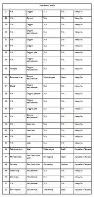
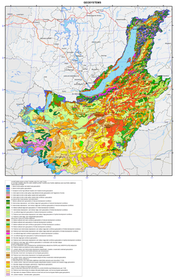
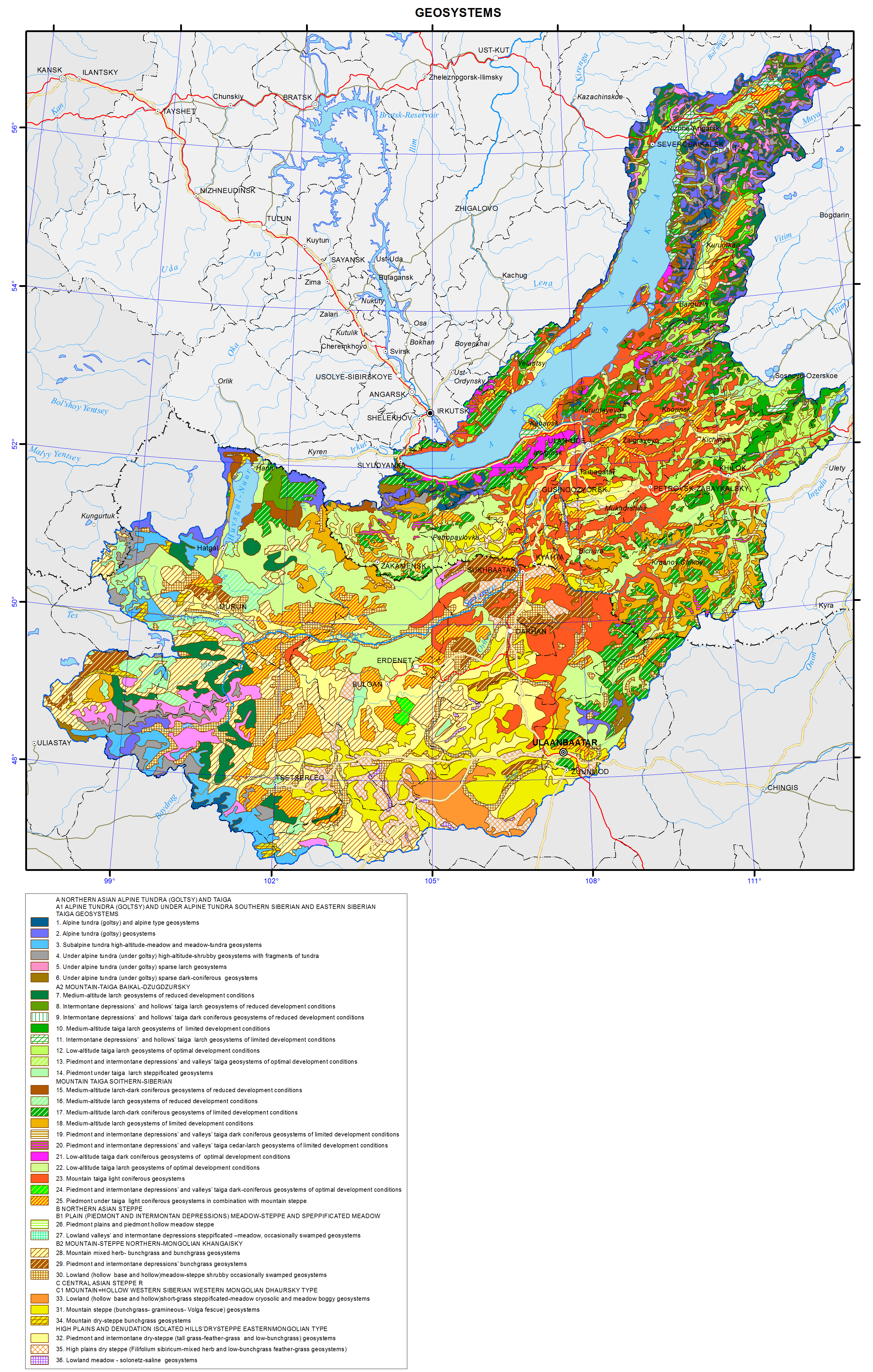
</p>
<p> </p>
<p align="center"><strong>Vegetation</strong></p>
<p>The map “Vegetation” is an overview-reference geobotanical map. All available different-scale cartographic materials on the vegetation of southern East Siberia of the Russian Federation, literary and archival sources, and forest inventory data were used when compiling the map. For the territory of Northern Mongolia, basic cartographic and literary materials on the vegetation of this region of Central Asia were involved. For the entire area of the Baikal basin modern satellite images from the Internet resources (Google Earth) were used. Their processing was carried out with the use of GIS technologies.</p>
<p>When creating the legend to the vegetation map of the Baikal region, well-tested geographical-genetic and structural-dynamic principles of a multi-dimensional and multi-stage vegetation classification, developed by Academician V.B. Sochava, were applied. Accordingly, the legend of the map has a multi-stage structure.</p>
<p>All higher subdivisions of vegetation in the map legend are united by specific taxa of plant communities, typed according to the flora-coenotic and dynamic features of their structure. When typing an epitaxon principle was followed, according to which on the basis of structural-dynamic and topological similarity indigenous communities are joined together with derivatives into common epitaxa. The lowest unit of indigenous communities being mapped is a class-group of associations. On the total the map legend contains 96 numbers of epitaxa of indigenous and derivative vegetation. Each taxon singled out in the legend has a detailed floristic, structural-coenotic and ecological-topological characteristics. Due to the complexity of the spatial structure of the vegetation cover, combinations and complexes of plant communities, which are the most characteristic of a particular type of vegetation or area, are almost universally used.</p>
<p>The highest level of the legend is formed by the following vegetation types: goletz (alpine), taiga (boreal) and steppe, communities of which form the modern vegetation cover of the Baikal basin. Each type of vegetation is presented by its set of communities of genetically close phratries of formations and their regional groups of formations.</p>
<p>Taiga (boreal) vegetation covers the main areas of the Baikal basin both in the plains and high plateaus, and in the mountains, forming a mountain-taiga altitudinal belt and a belt of subgoletz sparse forests. According to the landscape features of the region, taiga (boreal) vegetation is represented in the legend and in the map by several groups of formations, namely: subgoletz sparse forests with thickets of shrubs, mostly of Siberian dwarf pine, mountain-taiga forests, piedmont-hollow forests, and forests of plains and plateaus.</p>
<p>The first three groups represent an altitudinal-belt structure of vegetation of mountain ranges. Altitudinal-belt groups of formations of taiga (forest) vegetation are represented by communities of different origin and territorial confinedness.</p>
<p>In the contact zones of the taiga and steppe (in the form of islands) vegetation forest-steppe complexes are formed; they are mostly of expositional-conditional nature. Southern warm and dry slopes of mountains and hills are occupied, as a rule, by steppe groups, while northern and eastern cold slopes are covered with forest taiga and in some places steppificated communities. In accordance with the terrain features, these complexes are represented by three groups, namely: mountain, of plains and plateaus, and piedmont ones.</p>
<p>Steppe vegetation occupies large areas in the south of the Baikal basin and in northern Mongolia. Here there is an important biogeographical barrier that separates two large flora-coeno-genetic groups of western North Kazakhstan and eastern Central Asia steppes, representing Trans-Volga-Kazakhstan and Mongolian-Chinese phratries of formations, respectively.</p>
<p>Two groups of formations are clearly distinguished; they are mountain steppes and steppes of foothills, elevated plains and hummocks. In each of them, large ecological-morphological groups – meadow and dry steppes – are distinguished according to the nature of steppe vegetation. For each of these groups within the respective phratries of formations independent regional steppe complexes are identified, namely: Southern Siberian, northern Mongolian and Central Asian formations. The main areas, both in the mountains and on the plains and hummocks, are occupied by dry steppes of the Mongolian-Chinese phratrie of formations.</p>
<p>In general, the map reveals in details the spatial flora-coenotic structure of the vegetation cover of the Baikal basin in its evolutionary-genetic and dynamic dependence. Regional-geographical features of the coenotic diversity are well identified, taking into account their zonal-subzonal or altitudinal development conditions.</p>]]></content:encoded>
    <dc:publisher>No publisher</dc:publisher>
    <dc:creator>Alexander Ayurzhanaev</dc:creator>
    <dc:rights></dc:rights>
    <dc:date>2014-10-07T03:10:00Z</dc:date>
    <dc:type>Page</dc:type>
  </item>


  <item rdf:about="http://bic.iwlearn.org/en/atlas/atlas/32-permafrost-zoning-map/permafrost-zoning-map">
    <title>Permafrost zoning map</title>
    <link>http://bic.iwlearn.org/en/atlas/atlas/32-permafrost-zoning-map/permafrost-zoning-map</link>
    <description></description>
    <content:encoded xmlns:content="http://purl.org/rss/1.0/modules/content/"><![CDATA[<p><img class="image-inline" src="../../../resolveuid/402c511222f14004bede73f90b452758/@@images/image/preview" /></p>
<p><a href="http://bic.iwlearn.org/en/atlas/photos/copy_of__32_Permafrostzoning.png" class="internal-link">Open full size</a></p>
<p align="center"><strong>Permafrost</strong></p>
<p>Permafrost occurs in abundance within the Baikal basin. According to the extent of spreading, thickness of a permafrost section and its temperature, the following five types of areas of permafrost distribution are distinguished: 1) continuous and discontinuous, 2) insular, 3) sparsely insular, 4) sporadic, and 5) without permafrost.</p>
<p><i>Continuous and discontinuous</i> permafrost is developed on all relief features in the mid- and high-mountain and goletz areas. Unfrozen rocks occur only under large rivers, lakes and in the zones of tectonic faults with the discharge of subsurface water, along the fissures of exogenous weathering, as well as on sands, gravels and karsted rocks. The permafrost thickness reaches 100-300 m, and up to 500-600 m on watersheds. The average annual temperature ranges from -0.5 ºC to -3 ºC. Frost mounds, thermokarst, frost weathering, aufeis formation, kurum (rock stream) formation, and solifluction should be mentioned among the prevailing cryogenic processes and phenomena.<i></i></p>
<p><i>Insular</i> permafrost. The permafrost thickness reaches 50-80 m. Islands of permafrost occur on all relief elements, but usually only in wet, waterlogged or shaded areas, and in mountains above abs. alt. of 1000-1200 m. Sand massifs and karsted rocks are usually unfrozen. The average annual temperature of permafrost ranges from -0.2 ºC to -1ºC. Thermokarst, frost mounds, aufeis formation, solifluction, and frost fracturing of soil are distinguished among the prevailing cryogenic processes and phenomena.<i></i></p>
<p><i>Sparsely insular</i> permafrost occurs in waterlogged areas in valley bottoms, and at the bottom parts of northern slopes of hills, composed of peaty (from the surface) clay rocks. The permafrost thickness reaches 20-30 m. The average annual temperature of permafrost ranges from -0.1ºC to -0.5ºC.<i></i></p>
<p><i>Sporadic</i> permafrost. Individual islands and lenses of permafrost occur only in wet lowlands, composed of peaty (from the surface) clay loams and sandy loams. The permafrost thickness reaches 10-15 m. The average annual temperature of permafrost varies from 0ºC to -0.2ºC. Seasonal frost mounds, relic thermokarst, and frost fracturing of soil are distinguished among the prevailing cryogenic processes and phenomena.</p>
<p>The area of <i>only seasonal</i> soil freezing has become of widespread occurrence in the Angara river valley and the Selenga river delta. Permafrost patches and neoformations are possible when developing a territory, composed of clay rocks. The depth of winter freezing of rocks ranges from 2-2.5 m in clay loams to 2.5-3 m in sands. Ground heaving, frost fracturing of soil, and relic thermokarst should be mentioned among the prevailing cryogenic processes and phenomena.</p>]]></content:encoded>
    <dc:publisher>No publisher</dc:publisher>
    <dc:creator>Alexander Ayurzhanaev</dc:creator>
    <dc:rights></dc:rights>
    <dc:date>2014-10-07T03:05:00Z</dc:date>
    <dc:type>Page</dc:type>
  </item>


  <item rdf:about="http://bic.iwlearn.org/en/atlas/atlas/31-groundwater-map/groundwater-map">
    <title>Groundwater map</title>
    <link>http://bic.iwlearn.org/en/atlas/atlas/31-groundwater-map/groundwater-map</link>
    <description></description>
    <content:encoded xmlns:content="http://purl.org/rss/1.0/modules/content/"><![CDATA[<p><img class="image-inline" src="../../../resolveuid/3560e2c3a87c48199165386b9e07d5c9/@@images/image/preview" /></p>
<p><a href="http://bic.iwlearn.org/en/atlas/photos/copy_of__31_Groundwater.png" class="internal-link">Open full size</a></p>
<p align="center"><strong>Groundwater</strong></p>
<p>The map is based on generalizing materials of the Institute of the Earth's Crust, and the Geological Surveys of Buryatia, Chita and Irkutsk using hydrogeological maps of 1:5000000 [Atlas..., 1983] and 1:4500000 scales [National Atlas ..., 1990].</p>
<p>During mapping the method of mapping the main aquifers (hydrogeological formations) was applied. Aquifers are distinguished according to structural and hydrogeological features, the prevailing type of water-ermeability, and reservoir properties of rocks.</p>
<p>In the Baikal basin pore-edge waters, confined to loose unconsolidated sediments of Mesozoic and Cenozoic age, have a wide distribution, as well as crack waters in all lithified metamorphic, igneous and sedimentary rocks of different ages from the Archaean to the end of the Paleozoic - Mesozoic inclusive.</p>
<p>Hydrogeologically, the Baikal basin is a complex system of artesian basins and hydrogeological massifs. Artesian basins occupy intermontane depressions composed of loose rocks of the sedimentary cover and crystalline basement rocks. They are characterized by pore-edge waters of the zone of active water exchange and crack waters, often pressure waters, and foundation waters. Hydrogeological massifs are composed with crystalline rocks of mountain- folded frame and can accommodate crack waters of exogenous fissuring. Thickness of the zone of active water exchange does not exceed 100-150 m.</p>
<p>Most watered are karst carbonate rocks, as well as zones of tectonic dislocations, intersecting the cropping-out foundation or spread along the contacts of sedimentary-metamorphic rocks with igneous and metamorphic rocks. They are often traced by upward unloading both of cold and thermal waters.</p>
<p align="center">References</p>
<p><i>Atlas of hydrogeological and engineering-geological maps of the USSR. Scale 1:5000000</i>. (1983).</p>
<p><i>National Atlas of the Mongolian People's Republic, scale 1:4500000.</i> (1990).</p>]]></content:encoded>
    <dc:publisher>No publisher</dc:publisher>
    <dc:creator>Alexander Ayurzhanaev</dc:creator>
    <dc:rights></dc:rights>
    <dc:date>2014-10-07T03:00:00Z</dc:date>
    <dc:type>Page</dc:type>
  </item>


  <item rdf:about="http://bic.iwlearn.org/en/atlas/atlas/29-floods-map/floods-map">
    <title>Floods map</title>
    <link>http://bic.iwlearn.org/en/atlas/atlas/29-floods-map/floods-map</link>
    <description></description>
    <content:encoded xmlns:content="http://purl.org/rss/1.0/modules/content/"><![CDATA[<p><img class="image-inline" src="../../../resolveuid/9e12e2631dc94ca08fd88f97f030f2af/@@images/image/preview" /></p>
<p><a href="http://bic.iwlearn.org/en/atlas/photos/copy_of__29_Floods.png" class="internal-link">Open full size</a></p>
<p align="center"><strong>Floods</strong></p>
<p>The aim of the flood map is to give an insight into distribution of flooding risk on the territory, and level of its danger to human activity and facilities of national economy. The map was compiled on the basis of reference materials of the national water resource inventory [Long-term…, 1986; Resources …, 1973], data on the flooding damage, and archival and cartographic materials.</p>
<p>Flood hazard is characterized by their genesis, recurrence, impact, damage, possibility and appropriateness of forecasting a dangerous situation. T.A. Borisova determined the integral risk of floods from the territorial assessment of risk caused by floods [Borisova, 2013] using private maps of disturbances of land of different categories and population (based on the estimation of physical, economic and social risks). Flood danger for the rivers of Southern Baikal flowing from the Khamar-Daban Ridge is determined through an expertise as there are no appropriate calculated data.</p>
<p>Severe floods take place at the Selenga, Khilok, Uda, Upper Angara, and Barguzin rivers. The depth of floodplain inundation does not exceed 0.5-1 m during common floods and reaches 1.8-3 m during severe floods. The height of the water layer increases downstream the rivers: for example, its height at the Selenga river near the settlement of Ust-Kyakhta is 1 m and near the city of Ulan-Ude increases up to 3 m. The longest floods (30-90 days) are observed in the valley of the Selenga river and downstream the  river. Shorter floods (up to 25 days) are recorded in the basins of the Barguzin, Upper Angara, Uda, Dzhida, and other rivers. The duration of floods at small rivers, flowing directly to Lake Baikal, is, as a rule, 3-7 days.</p>
<p>The increase of water levels and flow rates in the rivers under study are observed during spring floods caused by thawing of snow cover and glaciers and during summer rain floods. High water floods are not characteristic of rivers located in the southern part. Spring floods are observed in the rivers of the Selenga basin, as well as in the streams running from the Khamar-Daban and Primorsky Ridges. The rivers with spring-summer floods are located in the northern part of the territory (Upper Angara, Barguzin, Turka, Tyya, Rel, Goudzhekit, and others).</p>
<p>Breakup of the ice is often accompanied by ice jams resulting in sharp short-term water level increases. Such local floods are confined to certain areas of narrowing riverbeds or river oxbows. Areas where ice jams are most likely to occur are noted on the Selenga River (Omulyovka Mountain – village of Voznesenovka – Mostovoy sidetrack – settlement of Reid, etc.).</p>
<p>Rain floods usually start from the decrease of spring flood and are observed during the entire summer period. The highest water levels are usually recorded in July-August. The highest intensity of the water level increase is registered at the rivers of the Selenga basin. For instance, during the highest flood in 70 years on the Dzhida River (19/1) it was 4.5 m per day (Khamney level gauge) and 2.79 m per day (Dzhida level gauge). Besides, rapid water level increases of a number of mountain stream tributaries (Khamney, Kurba, Ona, etc.) are associated with their location in the permafrost zone which considerably decreases the infiltration capacity of the soils. Fluctuations of water levels in the Selenga river and in the lower reaches of its tributaries are smoother, which is attributed to the spreading of floods and regulatory influence of the plains. However, the damage from the floods in this area is the most severe as the floodplains are the deepest and flooding is the longest. Moreover, this territory is highly developed economically and densely populated.</p>
<p>Maxima of rain floods on the territory under study significantly prevail over the maxima of spring floods in both absolute value and their number of the total annual maxima [Kichigina, 2000]. The first ones are the most dangerous for the flood formation. The exception is some rivers in the northern regions (Upper Angara, Barguzin, Rel, and Tyya) where the spring flood is the main water regime phase. The map represents the distribution of cross-sections with the dominance of rain flood maxima and with comparable contribution of spring and rain flood maxima. Rain floods cause huge damage as they are widely spread, repeat many times and have a high rate of formation. They can flood both separate small basins and vast territories. Their timely and precise forecast is, as a rule, low. For example, the destructive rain flood that happened in July of 1966 caused a 3 m water increase in the Tuul river, and for several hours the city of Ulaanbaatar submerged and 130 people drowned.  Only for the Republic of Buryatia the damages in the Selenga river basin amounted to about 1.4 billion roubles in 1971, 0.7 billion roubles in 1973 and 40 billion roubles in 1993 (based on current prices). In Mongolia the damages are considerably lower due to the specific settlement patterns and the unique features of the economic use of alluvial lands.</p>
<p>On the southern coast of Lake Baikal (from the Mysovka River mouth to the Angara River outlet), on the south-eastern slope of the Baikal Ridge and in a number of the Selenga River tributaries, floods are often aggravated by mud flows [Makarov, 2012]. Mud floods are caused by heavy rains at the sites with significant slope steepness and easily washed-away loose soil. Mud flow processes mostly develop in the near-mouth areas of the rivers of the northern slope of the Khamar-Daban Ridge and along the Circum-Baikal railway. Mud flows have very destructive force, and they are able to cause significant damages. The increase of water level in such small rivers as the Pokhabikha, Tiganchikha and others can be caused by thawing of ice crust formed as a result of freezing of their river beds.</p>
<p>In general the rivers in the Baikal basin are related to high flood probability ones. Small floods on certain rivers are registered almost annually. Recurrence of severe floods over the period from 1936 to 2012 amounts to 5-12%. According to statistics the most severe last century’s floods were registered in 1932, 1936, 1971, 1973, 1993 and 1998.</p>
<p>The height of the water level on the floodplain and the duration of high water stand are important characteristics. The height depends on both severity of a flood and hydrological and morphological properties of a river. During floods on the Selenga river near the village of Ust’-Kyakhta is comes to 1-2 meters; in the conditions of a narrowing valley and a sufficient stream supply by the Dzhida and Chikoy rivers near the village of Novoselenginsk it sharply rises and may exceed 4 meters. By the city of Ulan-Ude it drops down to 2.2 meters and to 1 meter in the vast delta.</p>
<p>The duration of high water stand varies. Long-term water floods on a floodplain (25-40 days) are observed in the valley of the Selenga river and in the lower course of the Chikoy river. Shorter-term floods (up to 25 days) are registered in the basins of the Barguzin, Upper Angara, Uda and Dzhida and other rivers. On small mountain streams floods usually do not exceed 3-7 days.</p>
<p>3 to 5% of the basin’s territory is exposed to recurrent floods. However, these are largely the most developed and settled lands. For instance, within the Russian part of the Selenga river basin about 4.000 sq km of inundated landscapes may be exposed to flooding; 231.600 hectares or 9.5% are agricultural lands. On the rivers of the northern part (the Barguzin, the Upper Angara) almost 2.000 sq km are flooded, a quarter of them agricultural lands.</p>
<p>The list of settlements on the territory of the Baikal basin, which are at risk of flooding, was compiled using summarized archival and reference data. In total, 75 settlements were included into the flood zone. The settlements with the highest risk of flooding are marked on the map.</p>
<p><b> </b></p>
<p align="center">References</p>
<p>Borisova, T.A. (2013). <i>Natural-anthropogenic risks in the Lake Baikal basin.</i> Chief Ed. A. Tulokhonov, Novosibirsk: Akad. Izd-vo “Geo”, 2013, 126 p.</p>
<p class="1">Kichigina, N.V. (2000). Genetic and statistic analysis of maximal flow of rivers in South-East Siberia. In: <i>Natural and socio-economic conditions of Siberian regions.</i> Novosibirsk: Izd-vo SO RAN, pp. 19-22.</p>
<p>Makarov, S.A. (2012). <i>Mud flows in Cisbaikalia.</i> Irkutsk: Izd-vo Instituta geografii im. V.B. Sochavy SO RAN, 111 p.</p>
<p><i>Long-term data on regime and resources of surface land waters.</i> (1986). Leningrad: Gidrometeoizdat, issue 13, 346 p.; issue 14, 282 p.</p>
<p><i>Surface water resources of the USSR.</i> (1973). Leningrad: Gidrometeoizdat, 1972, vol. 16, issue 2, 586 p.; vol. 16, issue 3, 400 p.</p>]]></content:encoded>
    <dc:publisher>No publisher</dc:publisher>
    <dc:creator>Alexander Ayurzhanaev</dc:creator>
    <dc:rights></dc:rights>
    <dc:date>2014-10-07T02:55:00Z</dc:date>
    <dc:type>Page</dc:type>
  </item>


  <item rdf:about="http://bic.iwlearn.org/en/atlas/atlas/30-surface-water-self-purification-map/surface-water-self-purification-map">
    <title>Surface-water self-purification map</title>
    <link>http://bic.iwlearn.org/en/atlas/atlas/30-surface-water-self-purification-map/surface-water-self-purification-map</link>
    <description></description>
    <content:encoded xmlns:content="http://purl.org/rss/1.0/modules/content/"><![CDATA[<p><img class="image-inline" src="../../../resolveuid/75e49bfb3855477684f285f7e324811b/@@images/image/preview" /></p>
<p><a href="http://bic.iwlearn.org/en/atlas/photos/copy_of__30_SurfaceWaterSelfPurification.png" class="internal-link">Open full size</a></p>
<p align="center"><strong>Self-clarification condition of surface water</strong></p>
<p>The map "Self-clarification conditions of surface waters" reflects the potential of natural waters of the territory to neutralize the introduction of pollutants into water bodies and to restore the original properties and composition of water. The self-clarification capacity of water bodies is formed by chemical, physical and biological processes; the dominant role here is played by dilution and oxidation.</p>
<p>The process of dilution of pollutants with the waters of rivers and water bodies is directly dependent on the amount of water mass, and it can be characterized by the influx of water into a reservoir and the water flow rates in rivers during the minimum runoff (the largest environmental stress conditions). Given the lack of material on the inflow for the majority of the lakes, the evaluation of diluting ability was carried out according to the average annual water volume in the reservoirs.</p>
<p>The oxidation of organic substances depends on the amount of oxygen from the atmosphere, and is determined by the conditions of mixing and temperature control of water bodies. The amount of oxygen required for oxidation of the process is specified as the biochemical oxygen demand (BOD<sub>5</sub> and COD) and standardized for various substances at the water temperature of 20ºC. Because of insufficient data on BOD<sub>5</sub> and COD, the oxidative reactions intensity was assessed indirectly based on the average temperature within the warm period and the intensity of water overturn.</p>
<p>The water overturn in the reservoirs is influenced by the differences of density and dynamic parameters, such as churning, wind-induced surges, etc. The data on churning observations (as well as the inflow observation) for the waters of the Baikal region are not sufficient, that is responsible for indirect assessment of dynamic performance. Here, morphometric parameters are used as an indicator of overturn intensity, namely: the ratio of depth and area of the mirror, which characterizes the potential churning power. In watercourses the channel slopes are criterial for the overturn degree; the flow velocity depends on them.</p>
<p>As a result, the assessment criteria of self-clarification conditions of surface waters are temperature, flow rate and volume of water, stream slopes and morphometric parameters of reservoirs. According to the regional dimension of the territory the analysis was performed for medium and large catchment areas of the rivers (4 – 6<sup>th</sup> according to Strahler’s stream order) and lakes.</p>
<p>The parameterization of these characteristics is carried out with the help of statistical methods and comparative analyzes with the development of special scales and matrices. The inventory data on more than 200 waterways and 12 lakes and reservoirs of the Baikal basin was used for the map construction [Long-term…, 1986; Surface water resources..., 1972, 1973]. For most rivers on the territory the overturn intensity was determined for sections according to a longitudinal gradient. The range of slopes is divided into four groups: from the minimum values (0-2 ‰) for plain areas to the maximum (over 15 ‰) in the mountainous areas. The water temperature during the warm period was calculated as the average for four months (June - September), as on the rivers of the region's the water temperature transition over 0 °C is registered in May and October. The temperature scale is divided into three intervals - less than 10, 10 to 15, and above 15ºC. The water volume required to dilute pollutants was determined on the basis of the minimum 30-day river flow rates (seven gradations - from less than 10 to more than 800 m<sup>3</sup>/s) and the average annual water amount in water bodies (four gradations - from less than 10 to more than 500 m<sup>3</sup>).</p>
<p>Determination of the self-clarification conditions of rivers and water bodies was carried out in stages. Primarily, transformation of pollutant by biochemical processes was estimated, and then pollutant dilution conditions were analyzed. As a result, four categories of self-clarification degrees of water bodies were defined.</p>
<p>On the map the self-clarification conditions of water bodies are shown with colored along-channel linear curves and with shadings. The most favorable self-clarification conditions within the Baikal basin develop in some areas of the Selenga river. Most of the water bodies of the territory are classified as having satisfactory conditions.</p>
<p>The self-clarification capacity can be regarded as the criterion of sustainability (preservation of properties) of aquatic ecosystems to anthropogenic impact, and the map can be considered an element of environmental potential assessment of the area.</p>
<p><b> </b></p>
<p align="center">References</p>
<p><i>Long-term data on the regime and surface water resources. The Baikal basin.</i> (1986). Vol. 1, no. 14, Leningrad: Gidrometeoizdat, 361 p.</p>
<p><i>Surface water resources of the USSR.</i> (1972). Vol. 16, no. 3. Leningrad: Gidrometizdat, 595 p.</p>
<p><i>Surface water resources of the USSR.</i> (1973). Vol.16, no. 3, Gidrometeoizdat, 400 p.</p>]]></content:encoded>
    <dc:publisher>No publisher</dc:publisher>
    <dc:creator>Alexander Ayurzhanaev</dc:creator>
    <dc:rights></dc:rights>
    <dc:date>2014-10-07T02:55:00Z</dc:date>
    <dc:type>Page</dc:type>
  </item>


  <item rdf:about="http://bic.iwlearn.org/en/atlas/atlas/27-minimum-summer-runoff-map/minimum-summer-runoff-map">
    <title>Minimum summer runoff map</title>
    <link>http://bic.iwlearn.org/en/atlas/atlas/27-minimum-summer-runoff-map/minimum-summer-runoff-map</link>
    <description></description>
    <content:encoded xmlns:content="http://purl.org/rss/1.0/modules/content/"><![CDATA[<p><img class="image-inline" src="../../../resolveuid/4b69f3ed34cf465b9efd7b5d76fb36f5/@@images/image/preview" /></p>
<p><a href="http://bic.iwlearn.org/en/atlas/photos/copy_of__27_Minimumsummerrunoff.png" class="internal-link">Open full size</a></p>
<p align="center"><strong>Flow</strong></p>
<p>The map “Mean annual flow” reflects the formation patterns of the water regime of the territory, which are determined by the properties of landscapes to transform atmospheric moisture into the runoff.</p>
<p>For a water body basin, the surface runoff is the total amount of water loss from the watershed landscapes. The runoff rate from landscape complexes is determined by solving the inverse problem, i.e. identification of the connection of flow rate at the main stream station of a catchment with the runoff from landscapes, occupying its area, and is calculated based on the equation Q<sub>j</sub> = ∑q<sub>i</sub> f<sub>ij</sub><i>,</i><i> </i>where <i>j</i> is the index of the river basin, Q<sub>j</sub> is its runoff, L/s; q<sub>i</sub> is a modification of flow from the i-th landscape complex, L/s km<sup>2</sup>; f<sub>ij</sub> is an area of the j-th basin occupied by the i-th landscape, km<sup>2</sup>. Long-term average runoff data for small and medium-sized rivers of theLake Baikal basin were used in calculations for the map construction [Long-term…, 1986, http://www.r-arcticnet.sr.unh.edu]. Characteristics of landscape components were obtained on the basis of the materials on landscape of the Baikal region [Landscapes…, 1977, Natural..., 2009, Landscapes…, 1990, Lysanova et al., 2009]. In accordance with the regional dimension, generalization degree is chosen at the geom level, and their average annual flow moduli are determined. The territory on the map is divided into regions according to five gradations of the module - from less than 1 to more than 10 L/s km<sup>2</sup>.</p>
<p>The catchment area of the lake covers a variety of landscape zones and altitudinal belts, which makes a great contrast between the runoff rates. The highest annual flow moduli are formed within the goletz and mountain-taiga landscapes. Steppe and forest-steppe areas are distinguished by the minimum runoff rates, and in the desert regions of Mongolia (the Selenga river basin) flow formation almost does not take place.</p>
<p>The maps of minimum and maximum flow were compiled based on the typological landscape classification represented on the map [Landscapes…, 1977]. In the course of investigation, landscapes of different types were generalized by identifying the most hydrologically informative properties (morphological characteristics, vegetation structure, altitudinal zonation, etc.). As a result, more than 200 landscapes were combined into sixteen types of natural complexes, and runoff rates were determined for them. The moduli of maximum snow runoff and minimum summer runoff were calculated as described above.</p>
<p>Areas with the highest runoff of floods are confined to the mountain ranges and systems with goletz open woodlands and mountain-taiga landscapes. The main areas, distinguished by formation of frequent and high floods are the Baikalsky Range on the north-eastern end of the lake; Barguzinsky Range, located in the south-eastern part of the catchment, and the Khamar-Daban, covering the south-western shore of Lake Baikal. The values of the maximum flow modification are shown in three gradations on the map, namely: less than 25, 25-70, and more than 100 L/s km<sup>2</sup>.</p>
<p>Features of formation of the minimum summer runoff in the Baikal basin are associated with the regime of atmospheric moisture, as well as with the effects of altitude and exposition. The calculations and analysis of the minimum summer runoff have shown a relatively high water yield in the low-flow period from high-mountain taiga landscapes and extremely low river flow formation in the central areas of the Selenga river catchment and in Priolkhonie, which are covered with light coniferous landscapes and steppe complexes on slopes and plains. The map shows the value of the minimum flow in three gradations, namely: less than 1.5, 3.0-5.0, and more than 5.0 L/s km<sup>2</sup>.</p>
<p>Landscape-hydrological mapping based on the quantitative characteristics of water yield of landscape complexes objectively reflects the hydrological organization of the territory.</p>
<p><b> </b></p>
<p align="center">References</p>
<p>Kuznetsova T.I. (2009). Map "Natural landscapes of the Baikal region and their use: purpose, structure, and content”.  T.I. Kuznetsova, A.R. Batuev, and A.V. Bardash. <i>Geodeziya i kartografiya,</i> , no 9, pp. 18-28.</p>
<p>Landscapes of southern East Siberia [Maps]: [physical map] (1977) / compiled and prep. for printing by factory no. 4 GUGK in 1976, authors: V.S. Mikheev and V.A. Ryashin. 1: 1 500 000, Moscow: GUGK, 1 map (4 sheets): col.</p>
<p>Landscapes [Maps] [physical map] / The National Atlas of the Mongolian People's Republic. / comp .and prep to print by GUGK in 1989, authors: B.M. Ishmuratov, K.N. Misevich, I.L. Savelyeva, et al.</p>
<p>Lysanova, G.I., Semenov, Yu.M., Shekhovtsov, A.I., and Sorokovoy, A.A. (2013). Geosystems of the Republic of Tuva. <i>Geografiya i prirodnye resursy</i>, no. 3, pp. 181-185.</p>
<p>Long-term data on the regime and surface water resources. The Baikal basin. (1986). Vol. 1, no. 14, Leningrad: Gidrometeoizdat, 361 p.</p>
<p><b><i>A Regional, Electronic, Hydrographic Data Network For the Arctic Region.</i></b> <b>URL: </b><a href="http://www.r-arcticnet.sr.unh.edu/"><b>http://www.r-arcticnet.sr.unh.edu</b></a></p>]]></content:encoded>
    <dc:publisher>No publisher</dc:publisher>
    <dc:creator>Alexander Ayurzhanaev</dc:creator>
    <dc:rights></dc:rights>
    <dc:date>2014-10-07T02:55:00Z</dc:date>
    <dc:type>Page</dc:type>
  </item>


  <item rdf:about="http://bic.iwlearn.org/en/atlas/atlas/26-averagelong-termrunoff-map/averagelong-termrunoff-map">
    <title>Averagelong-termrunoff map</title>
    <link>http://bic.iwlearn.org/en/atlas/atlas/26-averagelong-termrunoff-map/averagelong-termrunoff-map</link>
    <description></description>
    <content:encoded xmlns:content="http://purl.org/rss/1.0/modules/content/"><![CDATA[<p><img class="image-inline" src="../../../resolveuid/31acccdebe1b4e038b93fce5440b5dd9/@@images/image/preview" /></p>
<p><a href="http://bic.iwlearn.org/en/atlas/photos/copy_of__26_Averagelongtermrunoff.png" class="internal-link">Open full size</a></p>
<p align="center"><strong>Flow</strong></p>
<p>The map “Mean annual flow” reflects the formation patterns of the water regime of the territory, which are determined by the properties of landscapes to transform atmospheric moisture into the runoff.</p>
<p>For a water body basin, the surface runoff is the total amount of water loss from the watershed landscapes. The runoff rate from landscape complexes is determined by solving the inverse problem, i.e. identification of the connection of flow rate at the main stream station of a catchment with the runoff from landscapes, occupying its area, and is calculated based on the equation Q<sub>j</sub> = ∑q<sub>i</sub> f<sub>ij</sub><i>,</i><i> </i>where <i>j</i> is the index of the river basin, Q<sub>j</sub> is its runoff, L/s; q<sub>i</sub> is a modification of flow from the i-th landscape complex, L/s km<sup>2</sup>; f<sub>ij</sub> is an area of the j-th basin occupied by the i-th landscape, km<sup>2</sup>. Long-term average runoff data for small and medium-sized rivers of theLake Baikal basin were used in calculations for the map construction [Long-term…, 1986, http://www.r-arcticnet.sr.unh.edu]. Characteristics of landscape components were obtained on the basis of the materials on landscape of the Baikal region [Landscapes…, 1977, Natural..., 2009, Landscapes…, 1990, Lysanova et al., 2009]. In accordance with the regional dimension, generalization degree is chosen at the geom level, and their average annual flow moduli are determined. The territory on the map is divided into regions according to five gradations of the module - from less than 1 to more than 10 L/s km<sup>2</sup>.</p>
<p>The catchment area of the lake covers a variety of landscape zones and altitudinal belts, which makes a great contrast between the runoff rates. The highest annual flow moduli are formed within the goletz and mountain-taiga landscapes. Steppe and forest-steppe areas are distinguished by the minimum runoff rates, and in the desert regions of Mongolia (the Selenga river basin) flow formation almost does not take place.</p>
<p>The maps of minimum and maximum flow were compiled based on the typological landscape classification represented on the map [Landscapes…, 1977]. In the course of investigation, landscapes of different types were generalized by identifying the most hydrologically informative properties (morphological characteristics, vegetation structure, altitudinal zonation, etc.). As a result, more than 200 landscapes were combined into sixteen types of natural complexes, and runoff rates were determined for them. The moduli of maximum snow runoff and minimum summer runoff were calculated as described above.</p>
<p>Areas with the highest runoff of floods are confined to the mountain ranges and systems with goletz open woodlands and mountain-taiga landscapes. The main areas, distinguished by formation of frequent and high floods are the Baikalsky Range on the north-eastern end of the lake; Barguzinsky Range, located in the south-eastern part of the catchment, and the Khamar-Daban, covering the south-western shore of Lake Baikal. The values of the maximum flow modification are shown in three gradations on the map, namely: less than 25, 25-70, and more than 100 L/s km<sup>2</sup>.</p>
<p>Features of formation of the minimum summer runoff in the Baikal basin are associated with the regime of atmospheric moisture, as well as with the effects of altitude and exposition. The calculations and analysis of the minimum summer runoff have shown a relatively high water yield in the low-flow period from high-mountain taiga landscapes and extremely low river flow formation in the central areas of the Selenga river catchment and in Priolkhonie, which are covered with light coniferous landscapes and steppe complexes on slopes and plains. The map shows the value of the minimum flow in three gradations, namely: less than 1.5, 3.0-5.0, and more than 5.0 L/s km<sup>2</sup>.</p>
<p>Landscape-hydrological mapping based on the quantitative characteristics of water yield of landscape complexes objectively reflects the hydrological organization of the territory.</p>
<p><b> </b></p>
<p align="center">References</p>
<p>Kuznetsova T.I. (2009). Map "Natural landscapes of the Baikal region and their use: purpose, structure, and content”.  T.I. Kuznetsova, A.R. Batuev, and A.V. Bardash. <i>Geodeziya i kartografiya,</i> , no 9, pp. 18-28.</p>
<p>Landscapes of southern East Siberia [Maps]: [physical map] (1977) / compiled and prep. for printing by factory no. 4 GUGK in 1976, authors: V.S. Mikheev and V.A. Ryashin. 1: 1 500 000, Moscow: GUGK, 1 map (4 sheets): col.</p>
<p>Landscapes [Maps] [physical map] / The National Atlas of the Mongolian People's Republic. / comp .and prep to print by GUGK in 1989, authors: B.M. Ishmuratov, K.N. Misevich, I.L. Savelyeva, et al.</p>
<p>Lysanova, G.I., Semenov, Yu.M., Shekhovtsov, A.I., and Sorokovoy, A.A. (2013). Geosystems of the Republic of Tuva. <i>Geografiya i prirodnye resursy</i>, no. 3, pp. 181-185.</p>
<p>Long-term data on the regime and surface water resources. The Baikal basin. (1986). Vol. 1, no. 14, Leningrad: Gidrometeoizdat, 361 p.</p>
<p><b><i>A Regional, Electronic, Hydrographic Data Network For the Arctic Region.</i> URL: <a href="http://www.r-arcticnet.sr.unh.edu/">http://www.r-arcticnet.sr.unh.edu</a></b></p>]]></content:encoded>
    <dc:publisher>No publisher</dc:publisher>
    <dc:creator>Alexander Ayurzhanaev</dc:creator>
    <dc:rights></dc:rights>
    <dc:date>2014-10-07T02:50:00Z</dc:date>
    <dc:type>Page</dc:type>
  </item>


  <item rdf:about="http://bic.iwlearn.org/en/atlas/atlas/25-drainage-density-map/drainage-density-map">
    <title>Drainage density map</title>
    <link>http://bic.iwlearn.org/en/atlas/atlas/25-drainage-density-map/drainage-density-map</link>
    <description></description>
    <content:encoded xmlns:content="http://purl.org/rss/1.0/modules/content/"><![CDATA[<p><img class="image-inline" src="../../../resolveuid/3038ad70e57045f38bce38b67e9a9563/@@images/image/preview" /></p>
<p><a href="http://bic.iwlearn.org/en/atlas/photos/copy_of__25_DrainageDensity.png" class="internal-link">Open full size</a></p>
<p align="center"><b>Degree of channelization</b></p>
<p>Differentiation of the degree of channelization of the Baikal basin has a clearly pronounced zonal nature: from 0.1 km/km<sup>2</sup> at the south-eastern boundary to 0.9 km/km<sup>2</sup> on the coastal ridges and in the northern territories. A high degree of channelization is characteristic of the taiga zone, especially of ranges and valleys immediately adjacent to the lake. In general, the northern part of the basin is characterized by favorable conditions of flow. Mountainous terrain, steep slopes and the presence of permafrost contribute to a rapid discharge of water into the main water streams, namely, the Upper Angara and the Barguzin, and to the development of the river network. The highest density is specific to the western slopes of the Barguzinsky (0.92 km/km<sup>2</sup>) and Khamar-Daban (0.69 km/km<sup>2</sup>) ranges. Among the plain territories, the most water-abundant areas are the Barguzin valley (0.89 km/km<sup>2</sup>) and the area of the Selenga river delta (0.68 km/km<sup>2</sup>).</p>
<p>The middle part of the basin is characterized by the mid-mountain terrain and a high occurrence of sandy and sandy loam soils. The presence of these factors provides for the average degree of channelization ranging from 0.35 km/km<sup>2</sup> in the middle reaches of the Selenga river and 0.55 km/km<sup>2</sup> for the Chikoy river basin to 0.61 km/km<sup>2</sup> for the Khilok and Dzhida river basins.</p>
<p>In physical-geographical terms, the south-western part of the basin, i.e. the area of Lake Khovsgol, represents a forest-steppe with the high-mountain depression terrain, and is characterized by a lower degree of channelization ranging from 0.32 km/km<sup>2</sup> for the Delger-Muren river basin to 0.34 km/km<sup>2</sup> for the Egiin-Gol river basin. In the southern dry steppe part of the basin a low degree of channelization is registered. This is especially typical for the Tuul and Kharaa river basins; here this index is below 0.2 km/km<sup>2</sup>.</p>]]></content:encoded>
    <dc:publisher>No publisher</dc:publisher>
    <dc:creator>Alexander Ayurzhanaev</dc:creator>
    <dc:rights></dc:rights>
    <dc:date>2014-10-07T02:50:00Z</dc:date>
    <dc:type>Page</dc:type>
  </item>


</rdf:RDF>
