<?xml version="1.0" encoding="utf-8" ?>
<rdf:RDF xmlns:rdf="http://www.w3.org/1999/02/22-rdf-syntax-ns#" xmlns:dc="http://purl.org/dc/elements/1.1/" xmlns:syn="http://purl.org/rss/1.0/modules/syndication/" xmlns="http://purl.org/rss/1.0/">


<channel rdf:about="http://bic.iwlearn.org/search_rss">
  <title>Байкальский информационный центр</title>
  <link>http://bic.iwlearn.org</link>

  <description>
    
            These are the search results for the query, showing results 191 to 205.
        
  </description>


  <image rdf:resource="http://bic.iwlearn.org/logo.png"/>

  <items>
    <rdf:Seq>
      
        <rdf:li rdf:resource="http://bic.iwlearn.org/en/atlas/atlas/31-groundwater-map/groundwater-map"/>
      
      
        <rdf:li rdf:resource="http://bic.iwlearn.org/en/atlas/atlas/29-floods-map/floods-map"/>
      
      
        <rdf:li rdf:resource="http://bic.iwlearn.org/en/atlas/atlas/30-surface-water-self-purification-map/surface-water-self-purification-map"/>
      
      
        <rdf:li rdf:resource="http://bic.iwlearn.org/en/atlas/atlas/27-minimum-summer-runoff-map/minimum-summer-runoff-map"/>
      
      
        <rdf:li rdf:resource="http://bic.iwlearn.org/en/atlas/atlas/26-averagelong-termrunoff-map/averagelong-termrunoff-map"/>
      
      
        <rdf:li rdf:resource="http://bic.iwlearn.org/en/atlas/atlas/25-drainage-density-map/drainage-density-map"/>
      
      
        <rdf:li rdf:resource="http://bic.iwlearn.org/en/atlas/atlas/24-annual-river-map/annual-river-map"/>
      
      
        <rdf:li rdf:resource="http://bic.iwlearn.org/en/atlas/atlas/23-atmosphere-self-purification-capacity-map/atmosphere-self-purification-capacity-map"/>
      
      
        <rdf:li rdf:resource="http://bic.iwlearn.org/en/atlas/atlas/22-climate-discomfort-map/climate-discomfort-map"/>
      
      
        <rdf:li rdf:resource="http://bic.iwlearn.org/en/atlas/atlas/06-geology-map/geology-map"/>
      
      
        <rdf:li rdf:resource="http://bic.iwlearn.org/en/atlas/atlas/82-tourism-map/tourism-map"/>
      
      
        <rdf:li rdf:resource="http://bic.iwlearn.org/en/atlas/atlas/28-maximum-runoff-during-the-flood-map/maximum-runoff-during-the-flood-map"/>
      
      
        <rdf:li rdf:resource="http://bic.iwlearn.org/en/friends/mongolian/ngo-network-report"/>
      
      
        <rdf:li rdf:resource="http://bic.iwlearn.org/en/documents/documents/papers/Geoinformational%20of%20Monitoring%20of%20Natural%20Landscape%20Baikal%20Basin%20-english.pdf"/>
      
      
        <rdf:li rdf:resource="http://bic.iwlearn.org/en/documents/documents/papers/Spatio-temporal%20dynamics%20of%20vegetation%20cover%20of%20arid%20and%20semiarid%20climatic%20zones%20in%20central%20Mongolia%20on%20the%20basis%20of%20time%20series%20NDVI%20and%20field%20studies%20-rus.pdf"/>
      
    </rdf:Seq>
  </items>

</channel>


  <item rdf:about="http://bic.iwlearn.org/en/atlas/atlas/31-groundwater-map/groundwater-map">
    <title>Groundwater map</title>
    <link>http://bic.iwlearn.org/en/atlas/atlas/31-groundwater-map/groundwater-map</link>
    <description></description>
    <content:encoded xmlns:content="http://purl.org/rss/1.0/modules/content/"><![CDATA[<p><img class="image-inline" src="../../../resolveuid/3560e2c3a87c48199165386b9e07d5c9/@@images/image/preview" /></p>
<p><a href="http://bic.iwlearn.org/en/atlas/photos/copy_of__31_Groundwater.png" class="internal-link">Open full size</a></p>
<p align="center"><strong>Groundwater</strong></p>
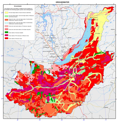
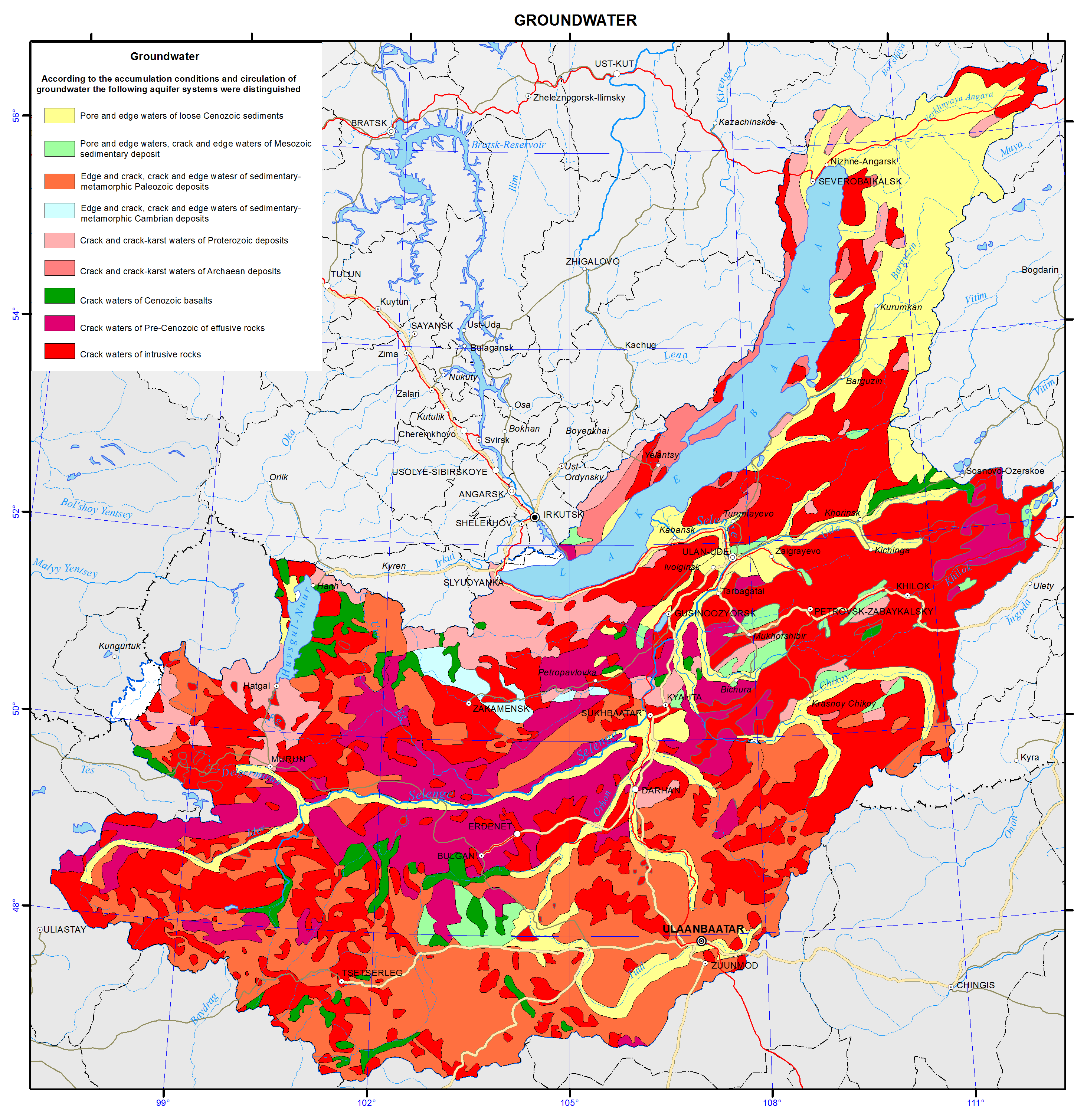
<p>The map is based on generalizing materials of the Institute of the Earth's Crust, and the Geological Surveys of Buryatia, Chita and Irkutsk using hydrogeological maps of 1:5000000 [Atlas..., 1983] and 1:4500000 scales [National Atlas ..., 1990].</p>
<p>During mapping the method of mapping the main aquifers (hydrogeological formations) was applied. Aquifers are distinguished according to structural and hydrogeological features, the prevailing type of water-ermeability, and reservoir properties of rocks.</p>
<p>In the Baikal basin pore-edge waters, confined to loose unconsolidated sediments of Mesozoic and Cenozoic age, have a wide distribution, as well as crack waters in all lithified metamorphic, igneous and sedimentary rocks of different ages from the Archaean to the end of the Paleozoic - Mesozoic inclusive.</p>
<p>Hydrogeologically, the Baikal basin is a complex system of artesian basins and hydrogeological massifs. Artesian basins occupy intermontane depressions composed of loose rocks of the sedimentary cover and crystalline basement rocks. They are characterized by pore-edge waters of the zone of active water exchange and crack waters, often pressure waters, and foundation waters. Hydrogeological massifs are composed with crystalline rocks of mountain- folded frame and can accommodate crack waters of exogenous fissuring. Thickness of the zone of active water exchange does not exceed 100-150 m.</p>
<p>Most watered are karst carbonate rocks, as well as zones of tectonic dislocations, intersecting the cropping-out foundation or spread along the contacts of sedimentary-metamorphic rocks with igneous and metamorphic rocks. They are often traced by upward unloading both of cold and thermal waters.</p>
<p align="center">References</p>
<p><i>Atlas of hydrogeological and engineering-geological maps of the USSR. Scale 1:5000000</i>. (1983).</p>
<p><i>National Atlas of the Mongolian People's Republic, scale 1:4500000.</i> (1990).</p>]]></content:encoded>
    <dc:publisher>No publisher</dc:publisher>
    <dc:creator>Alexander Ayurzhanaev</dc:creator>
    <dc:rights></dc:rights>
    <dc:date>2014-10-07T03:00:00Z</dc:date>
    <dc:type>Page</dc:type>
  </item>


  <item rdf:about="http://bic.iwlearn.org/en/atlas/atlas/29-floods-map/floods-map">
    <title>Floods map</title>
    <link>http://bic.iwlearn.org/en/atlas/atlas/29-floods-map/floods-map</link>
    <description></description>
    <content:encoded xmlns:content="http://purl.org/rss/1.0/modules/content/"><![CDATA[<p><img class="image-inline" src="../../../resolveuid/9e12e2631dc94ca08fd88f97f030f2af/@@images/image/preview" /></p>
<p><a href="http://bic.iwlearn.org/en/atlas/photos/copy_of__29_Floods.png" class="internal-link">Open full size</a></p>
<p align="center"><strong>Floods</strong></p>
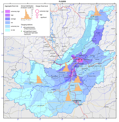
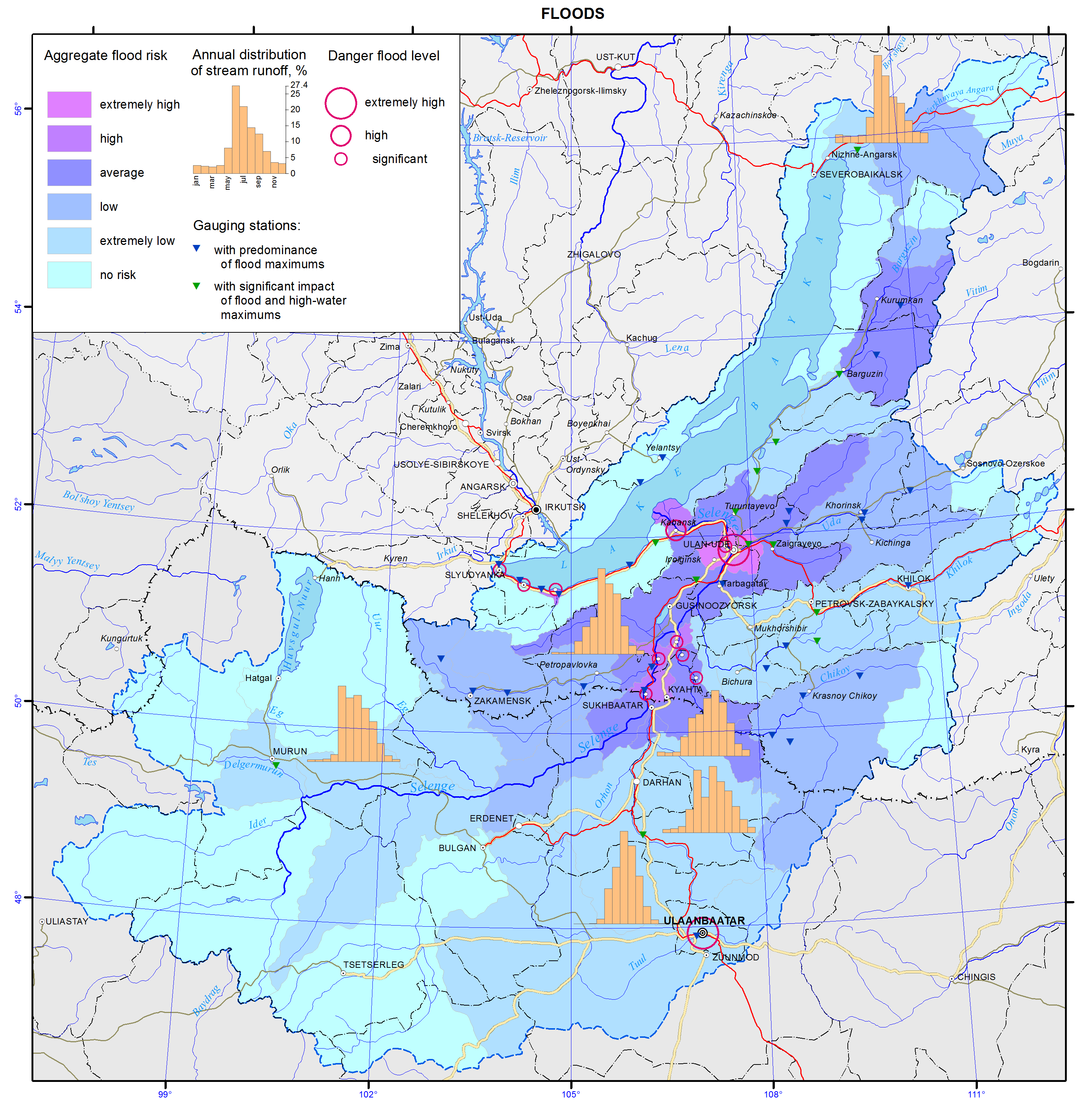
<p>The aim of the flood map is to give an insight into distribution of flooding risk on the territory, and level of its danger to human activity and facilities of national economy. The map was compiled on the basis of reference materials of the national water resource inventory [Long-term…, 1986; Resources …, 1973], data on the flooding damage, and archival and cartographic materials.</p>
<p>Flood hazard is characterized by their genesis, recurrence, impact, damage, possibility and appropriateness of forecasting a dangerous situation. T.A. Borisova determined the integral risk of floods from the territorial assessment of risk caused by floods [Borisova, 2013] using private maps of disturbances of land of different categories and population (based on the estimation of physical, economic and social risks). Flood danger for the rivers of Southern Baikal flowing from the Khamar-Daban Ridge is determined through an expertise as there are no appropriate calculated data.</p>
<p>Severe floods take place at the Selenga, Khilok, Uda, Upper Angara, and Barguzin rivers. The depth of floodplain inundation does not exceed 0.5-1 m during common floods and reaches 1.8-3 m during severe floods. The height of the water layer increases downstream the rivers: for example, its height at the Selenga river near the settlement of Ust-Kyakhta is 1 m and near the city of Ulan-Ude increases up to 3 m. The longest floods (30-90 days) are observed in the valley of the Selenga river and downstream the  river. Shorter floods (up to 25 days) are recorded in the basins of the Barguzin, Upper Angara, Uda, Dzhida, and other rivers. The duration of floods at small rivers, flowing directly to Lake Baikal, is, as a rule, 3-7 days.</p>
<p>The increase of water levels and flow rates in the rivers under study are observed during spring floods caused by thawing of snow cover and glaciers and during summer rain floods. High water floods are not characteristic of rivers located in the southern part. Spring floods are observed in the rivers of the Selenga basin, as well as in the streams running from the Khamar-Daban and Primorsky Ridges. The rivers with spring-summer floods are located in the northern part of the territory (Upper Angara, Barguzin, Turka, Tyya, Rel, Goudzhekit, and others).</p>
<p>Breakup of the ice is often accompanied by ice jams resulting in sharp short-term water level increases. Such local floods are confined to certain areas of narrowing riverbeds or river oxbows. Areas where ice jams are most likely to occur are noted on the Selenga River (Omulyovka Mountain – village of Voznesenovka – Mostovoy sidetrack – settlement of Reid, etc.).</p>
<p>Rain floods usually start from the decrease of spring flood and are observed during the entire summer period. The highest water levels are usually recorded in July-August. The highest intensity of the water level increase is registered at the rivers of the Selenga basin. For instance, during the highest flood in 70 years on the Dzhida River (19/1) it was 4.5 m per day (Khamney level gauge) and 2.79 m per day (Dzhida level gauge). Besides, rapid water level increases of a number of mountain stream tributaries (Khamney, Kurba, Ona, etc.) are associated with their location in the permafrost zone which considerably decreases the infiltration capacity of the soils. Fluctuations of water levels in the Selenga river and in the lower reaches of its tributaries are smoother, which is attributed to the spreading of floods and regulatory influence of the plains. However, the damage from the floods in this area is the most severe as the floodplains are the deepest and flooding is the longest. Moreover, this territory is highly developed economically and densely populated.</p>
<p>Maxima of rain floods on the territory under study significantly prevail over the maxima of spring floods in both absolute value and their number of the total annual maxima [Kichigina, 2000]. The first ones are the most dangerous for the flood formation. The exception is some rivers in the northern regions (Upper Angara, Barguzin, Rel, and Tyya) where the spring flood is the main water regime phase. The map represents the distribution of cross-sections with the dominance of rain flood maxima and with comparable contribution of spring and rain flood maxima. Rain floods cause huge damage as they are widely spread, repeat many times and have a high rate of formation. They can flood both separate small basins and vast territories. Their timely and precise forecast is, as a rule, low. For example, the destructive rain flood that happened in July of 1966 caused a 3 m water increase in the Tuul river, and for several hours the city of Ulaanbaatar submerged and 130 people drowned.  Only for the Republic of Buryatia the damages in the Selenga river basin amounted to about 1.4 billion roubles in 1971, 0.7 billion roubles in 1973 and 40 billion roubles in 1993 (based on current prices). In Mongolia the damages are considerably lower due to the specific settlement patterns and the unique features of the economic use of alluvial lands.</p>
<p>On the southern coast of Lake Baikal (from the Mysovka River mouth to the Angara River outlet), on the south-eastern slope of the Baikal Ridge and in a number of the Selenga River tributaries, floods are often aggravated by mud flows [Makarov, 2012]. Mud floods are caused by heavy rains at the sites with significant slope steepness and easily washed-away loose soil. Mud flow processes mostly develop in the near-mouth areas of the rivers of the northern slope of the Khamar-Daban Ridge and along the Circum-Baikal railway. Mud flows have very destructive force, and they are able to cause significant damages. The increase of water level in such small rivers as the Pokhabikha, Tiganchikha and others can be caused by thawing of ice crust formed as a result of freezing of their river beds.</p>
<p>In general the rivers in the Baikal basin are related to high flood probability ones. Small floods on certain rivers are registered almost annually. Recurrence of severe floods over the period from 1936 to 2012 amounts to 5-12%. According to statistics the most severe last century’s floods were registered in 1932, 1936, 1971, 1973, 1993 and 1998.</p>
<p>The height of the water level on the floodplain and the duration of high water stand are important characteristics. The height depends on both severity of a flood and hydrological and morphological properties of a river. During floods on the Selenga river near the village of Ust’-Kyakhta is comes to 1-2 meters; in the conditions of a narrowing valley and a sufficient stream supply by the Dzhida and Chikoy rivers near the village of Novoselenginsk it sharply rises and may exceed 4 meters. By the city of Ulan-Ude it drops down to 2.2 meters and to 1 meter in the vast delta.</p>
<p>The duration of high water stand varies. Long-term water floods on a floodplain (25-40 days) are observed in the valley of the Selenga river and in the lower course of the Chikoy river. Shorter-term floods (up to 25 days) are registered in the basins of the Barguzin, Upper Angara, Uda and Dzhida and other rivers. On small mountain streams floods usually do not exceed 3-7 days.</p>
<p>3 to 5% of the basin’s territory is exposed to recurrent floods. However, these are largely the most developed and settled lands. For instance, within the Russian part of the Selenga river basin about 4.000 sq km of inundated landscapes may be exposed to flooding; 231.600 hectares or 9.5% are agricultural lands. On the rivers of the northern part (the Barguzin, the Upper Angara) almost 2.000 sq km are flooded, a quarter of them agricultural lands.</p>
<p>The list of settlements on the territory of the Baikal basin, which are at risk of flooding, was compiled using summarized archival and reference data. In total, 75 settlements were included into the flood zone. The settlements with the highest risk of flooding are marked on the map.</p>
<p><b> </b></p>
<p align="center">References</p>
<p>Borisova, T.A. (2013). <i>Natural-anthropogenic risks in the Lake Baikal basin.</i> Chief Ed. A. Tulokhonov, Novosibirsk: Akad. Izd-vo “Geo”, 2013, 126 p.</p>
<p class="1">Kichigina, N.V. (2000). Genetic and statistic analysis of maximal flow of rivers in South-East Siberia. In: <i>Natural and socio-economic conditions of Siberian regions.</i> Novosibirsk: Izd-vo SO RAN, pp. 19-22.</p>
<p>Makarov, S.A. (2012). <i>Mud flows in Cisbaikalia.</i> Irkutsk: Izd-vo Instituta geografii im. V.B. Sochavy SO RAN, 111 p.</p>
<p><i>Long-term data on regime and resources of surface land waters.</i> (1986). Leningrad: Gidrometeoizdat, issue 13, 346 p.; issue 14, 282 p.</p>
<p><i>Surface water resources of the USSR.</i> (1973). Leningrad: Gidrometeoizdat, 1972, vol. 16, issue 2, 586 p.; vol. 16, issue 3, 400 p.</p>]]></content:encoded>
    <dc:publisher>No publisher</dc:publisher>
    <dc:creator>Alexander Ayurzhanaev</dc:creator>
    <dc:rights></dc:rights>
    <dc:date>2014-10-07T02:55:00Z</dc:date>
    <dc:type>Page</dc:type>
  </item>


  <item rdf:about="http://bic.iwlearn.org/en/atlas/atlas/30-surface-water-self-purification-map/surface-water-self-purification-map">
    <title>Surface-water self-purification map</title>
    <link>http://bic.iwlearn.org/en/atlas/atlas/30-surface-water-self-purification-map/surface-water-self-purification-map</link>
    <description></description>
    <content:encoded xmlns:content="http://purl.org/rss/1.0/modules/content/"><![CDATA[<p><img class="image-inline" src="../../../resolveuid/75e49bfb3855477684f285f7e324811b/@@images/image/preview" /></p>
<p><a href="http://bic.iwlearn.org/en/atlas/photos/copy_of__30_SurfaceWaterSelfPurification.png" class="internal-link">Open full size</a></p>
<p align="center"><strong>Self-clarification condition of surface water</strong></p>
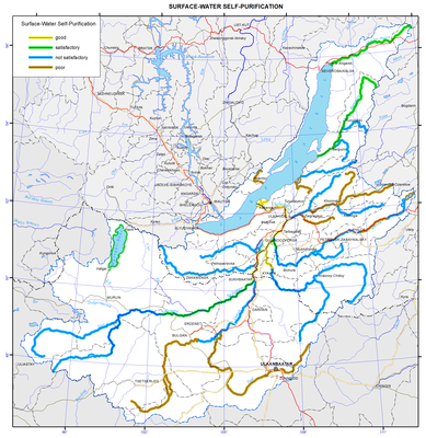
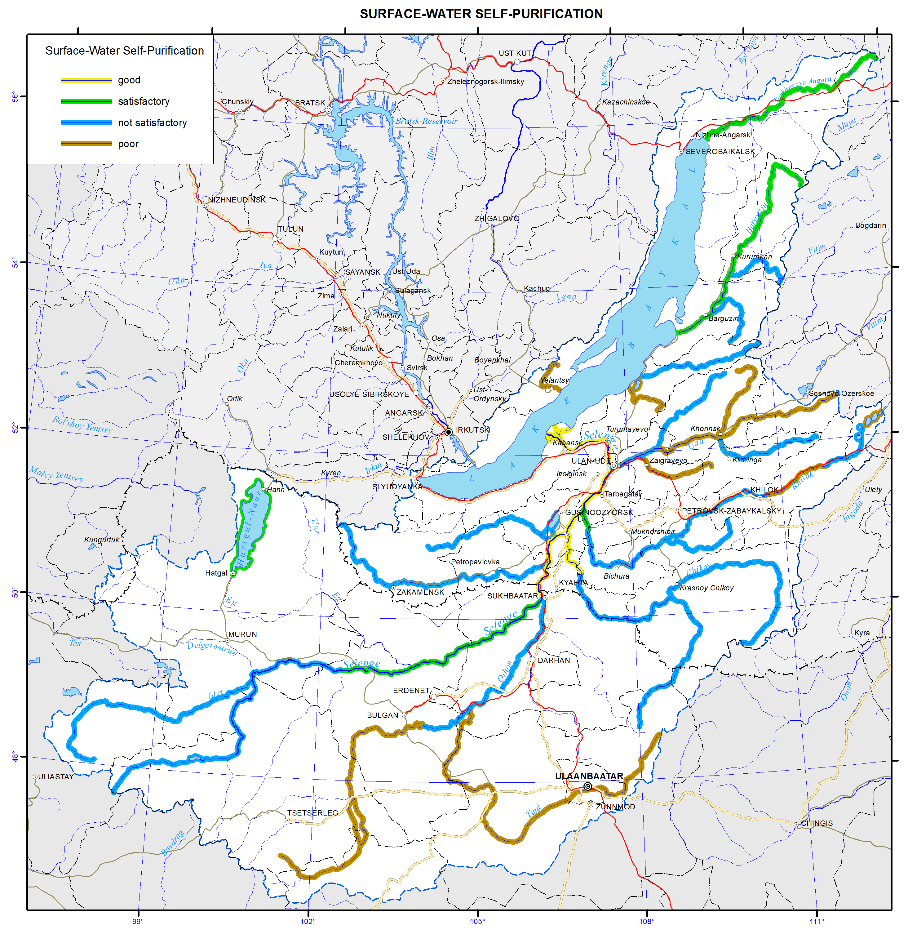
<p>The map "Self-clarification conditions of surface waters" reflects the potential of natural waters of the territory to neutralize the introduction of pollutants into water bodies and to restore the original properties and composition of water. The self-clarification capacity of water bodies is formed by chemical, physical and biological processes; the dominant role here is played by dilution and oxidation.</p>
<p>The process of dilution of pollutants with the waters of rivers and water bodies is directly dependent on the amount of water mass, and it can be characterized by the influx of water into a reservoir and the water flow rates in rivers during the minimum runoff (the largest environmental stress conditions). Given the lack of material on the inflow for the majority of the lakes, the evaluation of diluting ability was carried out according to the average annual water volume in the reservoirs.</p>
<p>The oxidation of organic substances depends on the amount of oxygen from the atmosphere, and is determined by the conditions of mixing and temperature control of water bodies. The amount of oxygen required for oxidation of the process is specified as the biochemical oxygen demand (BOD<sub>5</sub> and COD) and standardized for various substances at the water temperature of 20ºC. Because of insufficient data on BOD<sub>5</sub> and COD, the oxidative reactions intensity was assessed indirectly based on the average temperature within the warm period and the intensity of water overturn.</p>
<p>The water overturn in the reservoirs is influenced by the differences of density and dynamic parameters, such as churning, wind-induced surges, etc. The data on churning observations (as well as the inflow observation) for the waters of the Baikal region are not sufficient, that is responsible for indirect assessment of dynamic performance. Here, morphometric parameters are used as an indicator of overturn intensity, namely: the ratio of depth and area of the mirror, which characterizes the potential churning power. In watercourses the channel slopes are criterial for the overturn degree; the flow velocity depends on them.</p>
<p>As a result, the assessment criteria of self-clarification conditions of surface waters are temperature, flow rate and volume of water, stream slopes and morphometric parameters of reservoirs. According to the regional dimension of the territory the analysis was performed for medium and large catchment areas of the rivers (4 – 6<sup>th</sup> according to Strahler’s stream order) and lakes.</p>
<p>The parameterization of these characteristics is carried out with the help of statistical methods and comparative analyzes with the development of special scales and matrices. The inventory data on more than 200 waterways and 12 lakes and reservoirs of the Baikal basin was used for the map construction [Long-term…, 1986; Surface water resources..., 1972, 1973]. For most rivers on the territory the overturn intensity was determined for sections according to a longitudinal gradient. The range of slopes is divided into four groups: from the minimum values (0-2 ‰) for plain areas to the maximum (over 15 ‰) in the mountainous areas. The water temperature during the warm period was calculated as the average for four months (June - September), as on the rivers of the region's the water temperature transition over 0 °C is registered in May and October. The temperature scale is divided into three intervals - less than 10, 10 to 15, and above 15ºC. The water volume required to dilute pollutants was determined on the basis of the minimum 30-day river flow rates (seven gradations - from less than 10 to more than 800 m<sup>3</sup>/s) and the average annual water amount in water bodies (four gradations - from less than 10 to more than 500 m<sup>3</sup>).</p>
<p>Determination of the self-clarification conditions of rivers and water bodies was carried out in stages. Primarily, transformation of pollutant by biochemical processes was estimated, and then pollutant dilution conditions were analyzed. As a result, four categories of self-clarification degrees of water bodies were defined.</p>
<p>On the map the self-clarification conditions of water bodies are shown with colored along-channel linear curves and with shadings. The most favorable self-clarification conditions within the Baikal basin develop in some areas of the Selenga river. Most of the water bodies of the territory are classified as having satisfactory conditions.</p>
<p>The self-clarification capacity can be regarded as the criterion of sustainability (preservation of properties) of aquatic ecosystems to anthropogenic impact, and the map can be considered an element of environmental potential assessment of the area.</p>
<p><b> </b></p>
<p align="center">References</p>
<p><i>Long-term data on the regime and surface water resources. The Baikal basin.</i> (1986). Vol. 1, no. 14, Leningrad: Gidrometeoizdat, 361 p.</p>
<p><i>Surface water resources of the USSR.</i> (1972). Vol. 16, no. 3. Leningrad: Gidrometizdat, 595 p.</p>
<p><i>Surface water resources of the USSR.</i> (1973). Vol.16, no. 3, Gidrometeoizdat, 400 p.</p>]]></content:encoded>
    <dc:publisher>No publisher</dc:publisher>
    <dc:creator>Alexander Ayurzhanaev</dc:creator>
    <dc:rights></dc:rights>
    <dc:date>2014-10-07T02:55:00Z</dc:date>
    <dc:type>Page</dc:type>
  </item>


  <item rdf:about="http://bic.iwlearn.org/en/atlas/atlas/27-minimum-summer-runoff-map/minimum-summer-runoff-map">
    <title>Minimum summer runoff map</title>
    <link>http://bic.iwlearn.org/en/atlas/atlas/27-minimum-summer-runoff-map/minimum-summer-runoff-map</link>
    <description></description>
    <content:encoded xmlns:content="http://purl.org/rss/1.0/modules/content/"><![CDATA[<p><img class="image-inline" src="../../../resolveuid/4b69f3ed34cf465b9efd7b5d76fb36f5/@@images/image/preview" /></p>
<p><a href="http://bic.iwlearn.org/en/atlas/photos/copy_of__27_Minimumsummerrunoff.png" class="internal-link">Open full size</a></p>
<p align="center"><strong>Flow</strong></p>
<p>The map “Mean annual flow” reflects the formation patterns of the water regime of the territory, which are determined by the properties of landscapes to transform atmospheric moisture into the runoff.</p>
<p>For a water body basin, the surface runoff is the total amount of water loss from the watershed landscapes. The runoff rate from landscape complexes is determined by solving the inverse problem, i.e. identification of the connection of flow rate at the main stream station of a catchment with the runoff from landscapes, occupying its area, and is calculated based on the equation Q<sub>j</sub> = ∑q<sub>i</sub> f<sub>ij</sub><i>,</i><i> </i>where <i>j</i> is the index of the river basin, Q<sub>j</sub> is its runoff, L/s; q<sub>i</sub> is a modification of flow from the i-th landscape complex, L/s km<sup>2</sup>; f<sub>ij</sub> is an area of the j-th basin occupied by the i-th landscape, km<sup>2</sup>. Long-term average runoff data for small and medium-sized rivers of theLake Baikal basin were used in calculations for the map construction [Long-term…, 1986, http://www.r-arcticnet.sr.unh.edu]. Characteristics of landscape components were obtained on the basis of the materials on landscape of the Baikal region [Landscapes…, 1977, Natural..., 2009, Landscapes…, 1990, Lysanova et al., 2009]. In accordance with the regional dimension, generalization degree is chosen at the geom level, and their average annual flow moduli are determined. The territory on the map is divided into regions according to five gradations of the module - from less than 1 to more than 10 L/s km<sup>2</sup>.</p>
<p>The catchment area of the lake covers a variety of landscape zones and altitudinal belts, which makes a great contrast between the runoff rates. The highest annual flow moduli are formed within the goletz and mountain-taiga landscapes. Steppe and forest-steppe areas are distinguished by the minimum runoff rates, and in the desert regions of Mongolia (the Selenga river basin) flow formation almost does not take place.</p>
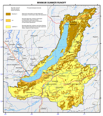
<p>The maps of minimum and maximum flow were compiled based on the typological landscape classification represented on the map [Landscapes…, 1977]. In the course of investigation, landscapes of different types were generalized by identifying the most hydrologically informative properties (morphological characteristics, vegetation structure, altitudinal zonation, etc.). As a result, more than 200 landscapes were combined into sixteen types of natural complexes, and runoff rates were determined for them. The moduli of maximum snow runoff and minimum summer runoff were calculated as described above.</p>
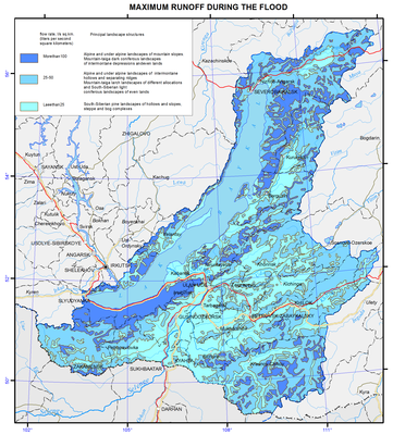
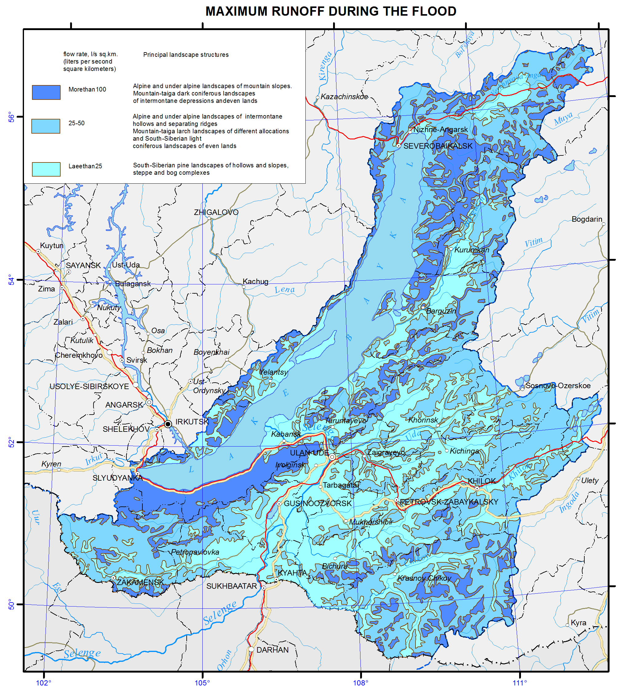
<p>Areas with the highest runoff of floods are confined to the mountain ranges and systems with goletz open woodlands and mountain-taiga landscapes. The main areas, distinguished by formation of frequent and high floods are the Baikalsky Range on the north-eastern end of the lake; Barguzinsky Range, located in the south-eastern part of the catchment, and the Khamar-Daban, covering the south-western shore of Lake Baikal. The values of the maximum flow modification are shown in three gradations on the map, namely: less than 25, 25-70, and more than 100 L/s km<sup>2</sup>.</p>
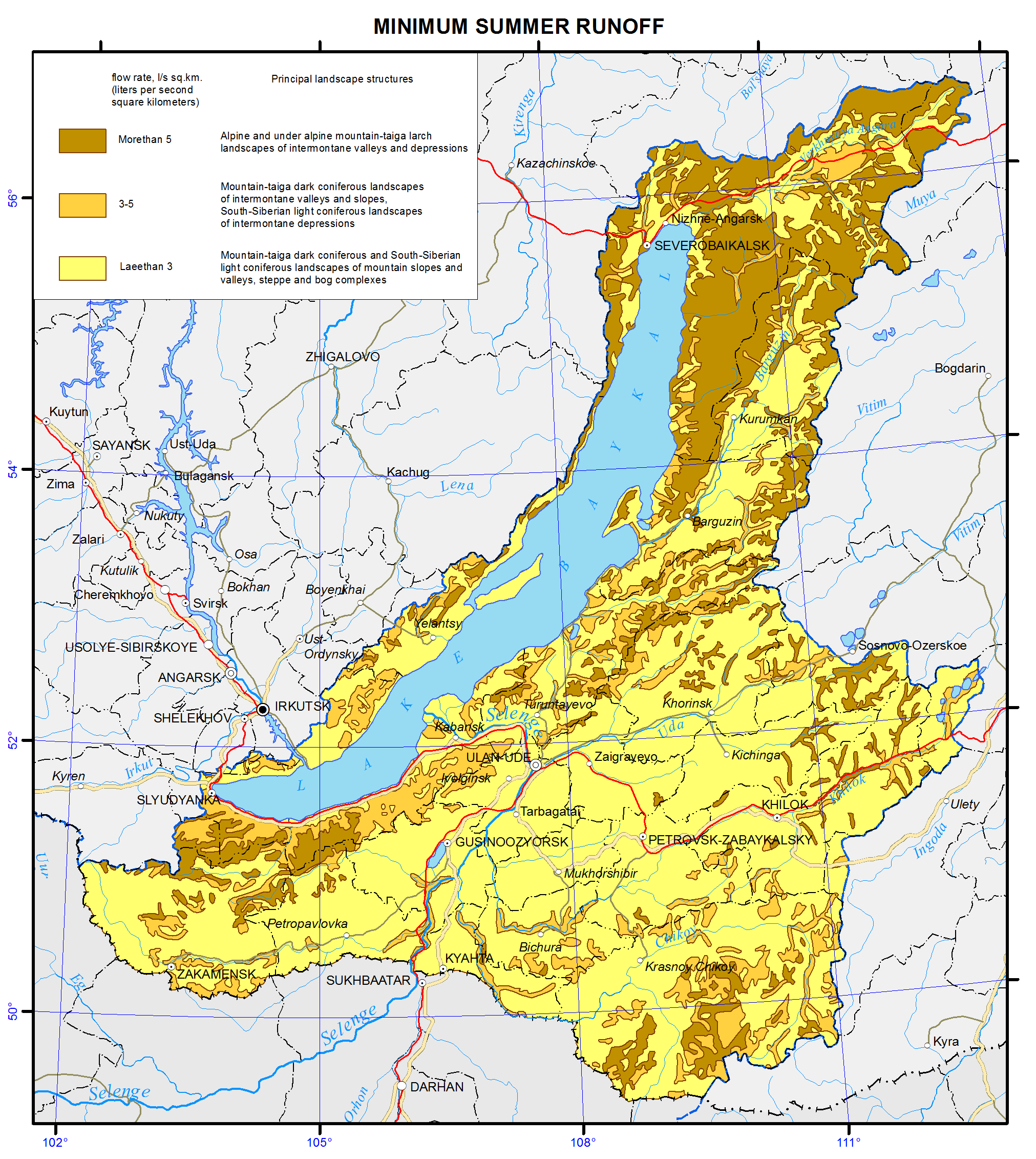
<p>Features of formation of the minimum summer runoff in the Baikal basin are associated with the regime of atmospheric moisture, as well as with the effects of altitude and exposition. The calculations and analysis of the minimum summer runoff have shown a relatively high water yield in the low-flow period from high-mountain taiga landscapes and extremely low river flow formation in the central areas of the Selenga river catchment and in Priolkhonie, which are covered with light coniferous landscapes and steppe complexes on slopes and plains. The map shows the value of the minimum flow in three gradations, namely: less than 1.5, 3.0-5.0, and more than 5.0 L/s km<sup>2</sup>.</p>
<p>Landscape-hydrological mapping based on the quantitative characteristics of water yield of landscape complexes objectively reflects the hydrological organization of the territory.</p>
<p><b> </b></p>
<p align="center">References</p>
<p>Kuznetsova T.I. (2009). Map "Natural landscapes of the Baikal region and their use: purpose, structure, and content”.  T.I. Kuznetsova, A.R. Batuev, and A.V. Bardash. <i>Geodeziya i kartografiya,</i> , no 9, pp. 18-28.</p>
<p>Landscapes of southern East Siberia [Maps]: [physical map] (1977) / compiled and prep. for printing by factory no. 4 GUGK in 1976, authors: V.S. Mikheev and V.A. Ryashin. 1: 1 500 000, Moscow: GUGK, 1 map (4 sheets): col.</p>
<p>Landscapes [Maps] [physical map] / The National Atlas of the Mongolian People's Republic. / comp .and prep to print by GUGK in 1989, authors: B.M. Ishmuratov, K.N. Misevich, I.L. Savelyeva, et al.</p>
<p>Lysanova, G.I., Semenov, Yu.M., Shekhovtsov, A.I., and Sorokovoy, A.A. (2013). Geosystems of the Republic of Tuva. <i>Geografiya i prirodnye resursy</i>, no. 3, pp. 181-185.</p>
<p>Long-term data on the regime and surface water resources. The Baikal basin. (1986). Vol. 1, no. 14, Leningrad: Gidrometeoizdat, 361 p.</p>
<p><b><i>A Regional, Electronic, Hydrographic Data Network For the Arctic Region.</i></b> <b>URL: </b><a href="http://www.r-arcticnet.sr.unh.edu/"><b>http://www.r-arcticnet.sr.unh.edu</b></a></p>]]></content:encoded>
    <dc:publisher>No publisher</dc:publisher>
    <dc:creator>Alexander Ayurzhanaev</dc:creator>
    <dc:rights></dc:rights>
    <dc:date>2014-10-07T02:55:00Z</dc:date>
    <dc:type>Page</dc:type>
  </item>


  <item rdf:about="http://bic.iwlearn.org/en/atlas/atlas/26-averagelong-termrunoff-map/averagelong-termrunoff-map">
    <title>Averagelong-termrunoff map</title>
    <link>http://bic.iwlearn.org/en/atlas/atlas/26-averagelong-termrunoff-map/averagelong-termrunoff-map</link>
    <description></description>
    <content:encoded xmlns:content="http://purl.org/rss/1.0/modules/content/"><![CDATA[<p><img class="image-inline" src="../../../resolveuid/31acccdebe1b4e038b93fce5440b5dd9/@@images/image/preview" /></p>
<p><a href="http://bic.iwlearn.org/en/atlas/photos/copy_of__26_Averagelongtermrunoff.png" class="internal-link">Open full size</a></p>
<p align="center"><strong>Flow</strong></p>
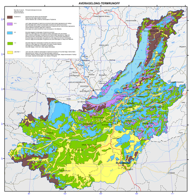
<p>The map “Mean annual flow” reflects the formation patterns of the water regime of the territory, which are determined by the properties of landscapes to transform atmospheric moisture into the runoff.</p>
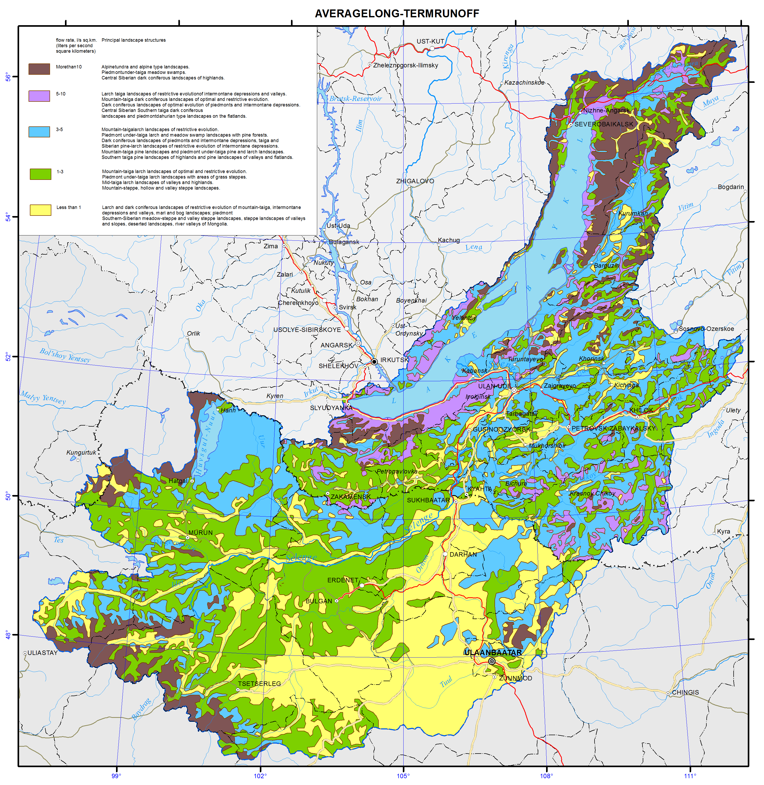
<p>For a water body basin, the surface runoff is the total amount of water loss from the watershed landscapes. The runoff rate from landscape complexes is determined by solving the inverse problem, i.e. identification of the connection of flow rate at the main stream station of a catchment with the runoff from landscapes, occupying its area, and is calculated based on the equation Q<sub>j</sub> = ∑q<sub>i</sub> f<sub>ij</sub><i>,</i><i> </i>where <i>j</i> is the index of the river basin, Q<sub>j</sub> is its runoff, L/s; q<sub>i</sub> is a modification of flow from the i-th landscape complex, L/s km<sup>2</sup>; f<sub>ij</sub> is an area of the j-th basin occupied by the i-th landscape, km<sup>2</sup>. Long-term average runoff data for small and medium-sized rivers of theLake Baikal basin were used in calculations for the map construction [Long-term…, 1986, http://www.r-arcticnet.sr.unh.edu]. Characteristics of landscape components were obtained on the basis of the materials on landscape of the Baikal region [Landscapes…, 1977, Natural..., 2009, Landscapes…, 1990, Lysanova et al., 2009]. In accordance with the regional dimension, generalization degree is chosen at the geom level, and their average annual flow moduli are determined. The territory on the map is divided into regions according to five gradations of the module - from less than 1 to more than 10 L/s km<sup>2</sup>.</p>
<p>The catchment area of the lake covers a variety of landscape zones and altitudinal belts, which makes a great contrast between the runoff rates. The highest annual flow moduli are formed within the goletz and mountain-taiga landscapes. Steppe and forest-steppe areas are distinguished by the minimum runoff rates, and in the desert regions of Mongolia (the Selenga river basin) flow formation almost does not take place.</p>
<p>The maps of minimum and maximum flow were compiled based on the typological landscape classification represented on the map [Landscapes…, 1977]. In the course of investigation, landscapes of different types were generalized by identifying the most hydrologically informative properties (morphological characteristics, vegetation structure, altitudinal zonation, etc.). As a result, more than 200 landscapes were combined into sixteen types of natural complexes, and runoff rates were determined for them. The moduli of maximum snow runoff and minimum summer runoff were calculated as described above.</p>
<p>Areas with the highest runoff of floods are confined to the mountain ranges and systems with goletz open woodlands and mountain-taiga landscapes. The main areas, distinguished by formation of frequent and high floods are the Baikalsky Range on the north-eastern end of the lake; Barguzinsky Range, located in the south-eastern part of the catchment, and the Khamar-Daban, covering the south-western shore of Lake Baikal. The values of the maximum flow modification are shown in three gradations on the map, namely: less than 25, 25-70, and more than 100 L/s km<sup>2</sup>.</p>
<p>Features of formation of the minimum summer runoff in the Baikal basin are associated with the regime of atmospheric moisture, as well as with the effects of altitude and exposition. The calculations and analysis of the minimum summer runoff have shown a relatively high water yield in the low-flow period from high-mountain taiga landscapes and extremely low river flow formation in the central areas of the Selenga river catchment and in Priolkhonie, which are covered with light coniferous landscapes and steppe complexes on slopes and plains. The map shows the value of the minimum flow in three gradations, namely: less than 1.5, 3.0-5.0, and more than 5.0 L/s km<sup>2</sup>.</p>
<p>Landscape-hydrological mapping based on the quantitative characteristics of water yield of landscape complexes objectively reflects the hydrological organization of the territory.</p>
<p><b> </b></p>
<p align="center">References</p>
<p>Kuznetsova T.I. (2009). Map "Natural landscapes of the Baikal region and their use: purpose, structure, and content”.  T.I. Kuznetsova, A.R. Batuev, and A.V. Bardash. <i>Geodeziya i kartografiya,</i> , no 9, pp. 18-28.</p>
<p>Landscapes of southern East Siberia [Maps]: [physical map] (1977) / compiled and prep. for printing by factory no. 4 GUGK in 1976, authors: V.S. Mikheev and V.A. Ryashin. 1: 1 500 000, Moscow: GUGK, 1 map (4 sheets): col.</p>
<p>Landscapes [Maps] [physical map] / The National Atlas of the Mongolian People's Republic. / comp .and prep to print by GUGK in 1989, authors: B.M. Ishmuratov, K.N. Misevich, I.L. Savelyeva, et al.</p>
<p>Lysanova, G.I., Semenov, Yu.M., Shekhovtsov, A.I., and Sorokovoy, A.A. (2013). Geosystems of the Republic of Tuva. <i>Geografiya i prirodnye resursy</i>, no. 3, pp. 181-185.</p>
<p>Long-term data on the regime and surface water resources. The Baikal basin. (1986). Vol. 1, no. 14, Leningrad: Gidrometeoizdat, 361 p.</p>
<p><b><i>A Regional, Electronic, Hydrographic Data Network For the Arctic Region.</i> URL: <a href="http://www.r-arcticnet.sr.unh.edu/">http://www.r-arcticnet.sr.unh.edu</a></b></p>]]></content:encoded>
    <dc:publisher>No publisher</dc:publisher>
    <dc:creator>Alexander Ayurzhanaev</dc:creator>
    <dc:rights></dc:rights>
    <dc:date>2014-10-07T02:50:00Z</dc:date>
    <dc:type>Page</dc:type>
  </item>


  <item rdf:about="http://bic.iwlearn.org/en/atlas/atlas/25-drainage-density-map/drainage-density-map">
    <title>Drainage density map</title>
    <link>http://bic.iwlearn.org/en/atlas/atlas/25-drainage-density-map/drainage-density-map</link>
    <description></description>
    <content:encoded xmlns:content="http://purl.org/rss/1.0/modules/content/"><![CDATA[<p><img class="image-inline" src="../../../resolveuid/3038ad70e57045f38bce38b67e9a9563/@@images/image/preview" /></p>
<p><a href="http://bic.iwlearn.org/en/atlas/photos/copy_of__25_DrainageDensity.png" class="internal-link">Open full size</a></p>
<p align="center"><b>Degree of channelization</b></p>
<p>Differentiation of the degree of channelization of the Baikal basin has a clearly pronounced zonal nature: from 0.1 km/km<sup>2</sup> at the south-eastern boundary to 0.9 km/km<sup>2</sup> on the coastal ridges and in the northern territories. A high degree of channelization is characteristic of the taiga zone, especially of ranges and valleys immediately adjacent to the lake. In general, the northern part of the basin is characterized by favorable conditions of flow. Mountainous terrain, steep slopes and the presence of permafrost contribute to a rapid discharge of water into the main water streams, namely, the Upper Angara and the Barguzin, and to the development of the river network. The highest density is specific to the western slopes of the Barguzinsky (0.92 km/km<sup>2</sup>) and Khamar-Daban (0.69 km/km<sup>2</sup>) ranges. Among the plain territories, the most water-abundant areas are the Barguzin valley (0.89 km/km<sup>2</sup>) and the area of the Selenga river delta (0.68 km/km<sup>2</sup>).</p>
<p>The middle part of the basin is characterized by the mid-mountain terrain and a high occurrence of sandy and sandy loam soils. The presence of these factors provides for the average degree of channelization ranging from 0.35 km/km<sup>2</sup> in the middle reaches of the Selenga river and 0.55 km/km<sup>2</sup> for the Chikoy river basin to 0.61 km/km<sup>2</sup> for the Khilok and Dzhida river basins.</p>
<p>In physical-geographical terms, the south-western part of the basin, i.e. the area of Lake Khovsgol, represents a forest-steppe with the high-mountain depression terrain, and is characterized by a lower degree of channelization ranging from 0.32 km/km<sup>2</sup> for the Delger-Muren river basin to 0.34 km/km<sup>2</sup> for the Egiin-Gol river basin. In the southern dry steppe part of the basin a low degree of channelization is registered. This is especially typical for the Tuul and Kharaa river basins; here this index is below 0.2 km/km<sup>2</sup>.</p>]]></content:encoded>
    <dc:publisher>No publisher</dc:publisher>
    <dc:creator>Alexander Ayurzhanaev</dc:creator>
    <dc:rights></dc:rights>
    <dc:date>2014-10-07T02:50:00Z</dc:date>
    <dc:type>Page</dc:type>
  </item>


  <item rdf:about="http://bic.iwlearn.org/en/atlas/atlas/24-annual-river-map/annual-river-map">
    <title>Annual river map</title>
    <link>http://bic.iwlearn.org/en/atlas/atlas/24-annual-river-map/annual-river-map</link>
    <description></description>
    <content:encoded xmlns:content="http://purl.org/rss/1.0/modules/content/"><![CDATA[<p><img class="image-inline" src="../../../resolveuid/28367c3406d64ff2adcd86f613541919/@@images/image/preview" /></p>
<p><a href="http://bic.iwlearn.org/en/atlas/photos/copy_of__24_Annualriver.png" class="internal-link">Open full size</a></p>
<p align="center"><b>Annual river runoff</b></p>
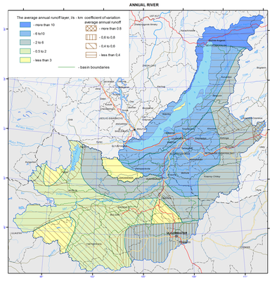
<p>The main rivers of the Baikal basin are the Selenga, giving about a half of the river flow into the lake, with its tributaries, namely, the Chikoy, Khilok, Orkhon, and Uda, as well as the Upper Angara, Barguzin, Turka, etc.</p>
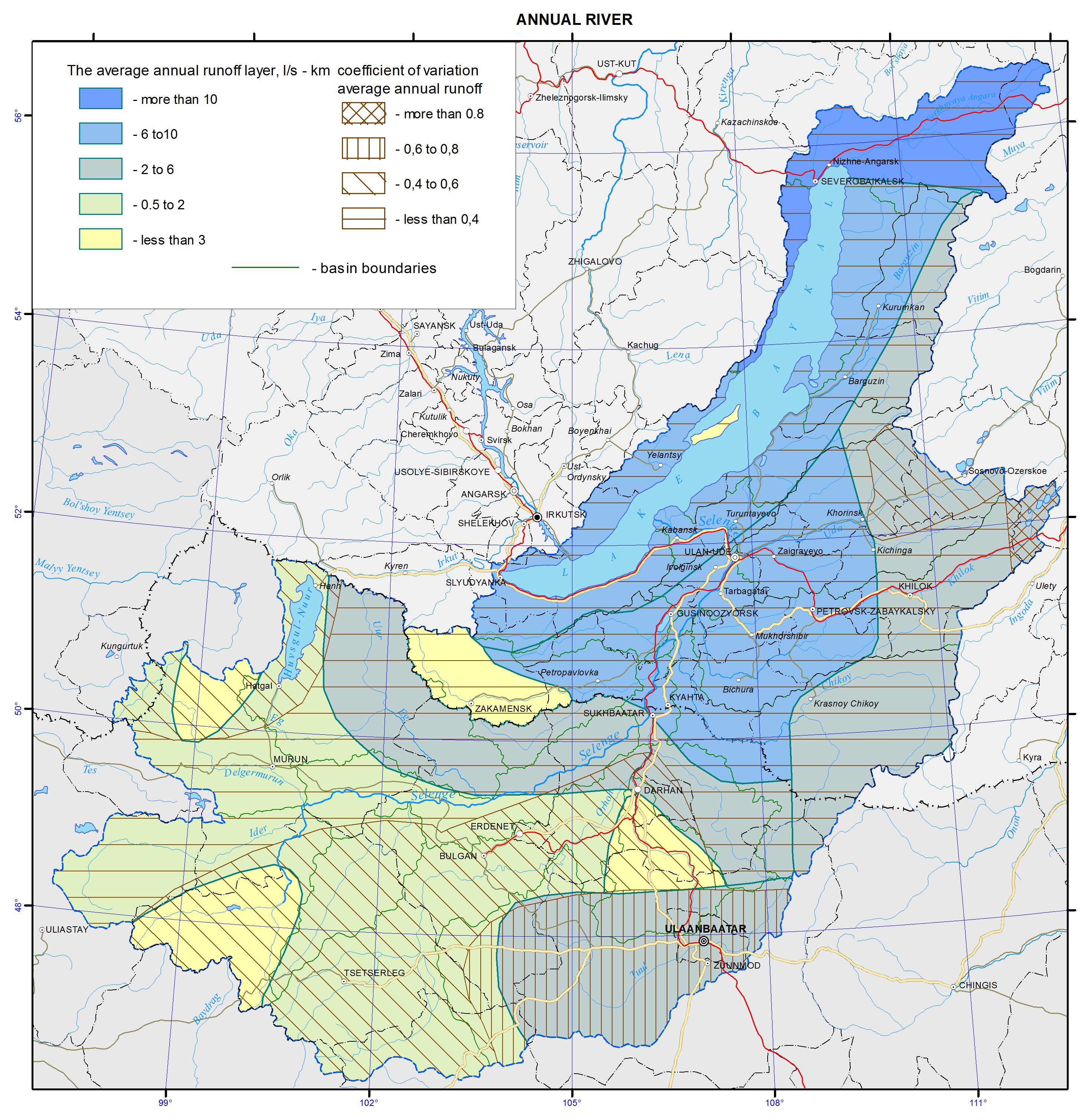
<p>Diversity of natural conditions of the Baikal basin causes large fluctuations in water content of rivers within the territory. The norm of the annual runoff varies from 0.62 to 27.8 L/s km<sup>2</sup>. Its value decreases from north to south, in accordance with a general decrease in precipitation and an increase in evaporation discharge. The maximum water content (from 12.7 to 27.8 L/s km<sup>2</sup>) is characteristic of the northmost rivers (the Upper Angara with its tributaries: Rel, Tyya, and Kholodnaya), as well as the rivers that originate on the slopes of the Khamar-Daban range (Bol’shaya Rechka, Snezhnaya, Khara-Murin, and Utulik). The rivers of the Ulan-Burgasy range, namely, the Turka and Kika, are characterized by high water content. The increased water content of 5.63 L/s km<sup>2</sup> (r. Eroo) to 9.70 L/s km<sup>2</sup> (r. Chikoy) is characteristic of the rivers of the Khentei-Chikoy highlands. The increased water content in the same range is also observed in the rivers of the Barguzin basin and in the watersheds of the Temnik and Tsakirka rivers, carrying their waters from the northern slopes of the Khamar-Daban.</p>
<p>The rivers of the Selenginskoe middle mountains and watercourses of the Mongolian part of the Baikal basin are characterized by the lowest water content (except for the above mentioned r. Eroo, a relatively high water content amounting to 4.65 L/s km<sup>2 </sup>is descriptive of the Tuul River with, which originates in the Khentei mountains). For all other river basins the norm of annual runoff ranges from about 1 to 3 L/s km<sup>2</sup>. The average annual runoff of the highly located watersheds of the rivers of the Khangai and Khovsgol regions is in the same range, which is due to the limited access of the moisture-bearing air masses. The greatest differences in the water content are observed in the Orkhon River basin due to combined effects of orography, terrain elevation, latitude, and soil-geological conditions.</p>
<p>The value of the variability of annual runoff has a general tendency of increasing from north to south and varies from 0.15 to 0.65 within the territory under consideration. Exceptions are provided by the sections of the upper reaches of the Khilok and Tuul rivers, where the values ​​of the variation coefficient are much higher. For example, in the r. Khilok–st. Sokhondo section line (<i>А</i>= 1900 km<sup>2</sup>) <i>Cv</i> = 1.32. The annual runoff module at this point varies from 0.01 (1978) to 5.84 L/s km<sup>2</sup> (1984). In winter, the river freezes over every year, and dries out in the summer low water years, and in some years there is no river runoff during 9 months (1965, 1967). In the r. Tuul–Ulaanbaatar section line (<i>А</i> = 6300 km<sup>2</sup>) <i>Cv</i>= 0.82, which is due to drying and through freezing of the river frequently observed here, as well as to a significant anthropogenic load. In this section line the average water consumption vary within wide limits and their values ​​can vary up to 13 times. For example,<i> Qav.</i> amounted to 5.00 m<sup>3</sup>/s in 1972, 60.5 m<sup>3</sup>/s in the following 1973, 65.3 m<sup>3</sup>/s in 1993, and 7.76 m<sup>3</sup>/s in 1996; there was no winter runoff in 60% of cases of the entire observation period.</p>]]></content:encoded>
    <dc:publisher>No publisher</dc:publisher>
    <dc:creator>Alexander Ayurzhanaev</dc:creator>
    <dc:rights></dc:rights>
    <dc:date>2014-10-07T02:50:00Z</dc:date>
    <dc:type>Page</dc:type>
  </item>


  <item rdf:about="http://bic.iwlearn.org/en/atlas/atlas/23-atmosphere-self-purification-capacity-map/atmosphere-self-purification-capacity-map">
    <title>Atmosphere self-purification capacity map</title>
    <link>http://bic.iwlearn.org/en/atlas/atlas/23-atmosphere-self-purification-capacity-map/atmosphere-self-purification-capacity-map</link>
    <description></description>
    <content:encoded xmlns:content="http://purl.org/rss/1.0/modules/content/"><![CDATA[<p><img class="image-inline" src="../../../resolveuid/3fb608e78f1945e6a53f1ee1d95f2c2a/@@images/image/preview" /></p>
<p><a href="http://bic.iwlearn.org/en/atlas/photos/copy_of__23_AtmosphereSelfPurificationCapacity.png" class="internal-link">Open full size</a></p>
<p align="center"><strong>Self-purification capacity of the atmosphere</strong><span> </span></p>
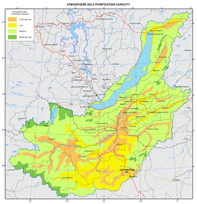
<p>The self-purification capacity of the atmosphere (SCA) over the continental part of the Asian mainland is largely determined by a combination of the interaction of its general circulation with the underlying surface. Because of the influence of regional characteristics of orographic systems, such as an alternation of dissected depressions, large mountain ridges and narrow valleys, this area is characterized by the formation of seasonal local baric centers. In winters, these are the fields of increased pressure in valleys and intermontane depressions, united into the Asian anticyclone centered over the north of Mongolia, whereas regions of closed thermal depressions are typical of summers. In water-filled depressions (such as the Baikal hollow), because of the influence of the water masses, the local field of increased and decreased pressure is observed in summer and winter, respectively. The strength of local baric centers determines the processes of energy and mass exchange with neighboring territories.</p>
<p>Under anticyclone conditions, a standard decrease in air temperature with height (vertical gradient 0.65 °C/100 m) is distorted, and its rise is observed. The mean thickness of sustained winter inversions approximates the anticyclone height, and its largest maximum intensity in January over the even lands (4-5 °C) and over the mountain depressions significantly differ [Sevastyanov, 1998].</p>
<p>Over the narrow valleys of the Russian part of the Baikal basin (Krasnyi Chikoy) the formation of a stable inversion is registered from November, and in some years, from October to March. The inversion intensity is largest in January, and the temperature difference at the station’s level and the 850 mb surface reaches 10−11 °C. With an enhancement in ruggedness of relief, there is an increase in the thickness and recurrence frequency of the number of days with surface inversion [Zhadambaa, 1972; Beresneva, 2006]. Thus, the average and the largest thicknesses of inversions over Ulaanbaatar and over the depressions in Western Mongolia can differ by a factor of 1.5 to 2. The highest recurrence frequency of inversions (about 50%) is observed when its thickness ranges from 500 to 1000 m in the former case, and from 1500 to 2500 m in the latter case. In the latter case the temperature difference on its upper and lower boundaries can reach 15−20 °C. Also, the deepest inversions with their high recurrence frequency and the lowest temperatures in the ground layer of atmospheric air are observed in stagnant locations. Due to the formation of inversions most stable in the cold year season over the area under study the free air exchange in the atmospheric boundary layer is disturbed. In such a situation, the quality of the atmospheric air in the ground layer will, to a significant extent, depend on local conditions, namely the recurrence frequency of calms and weak wind velocities, the precipitation amount, and on the amount of incoming impurities.</p>
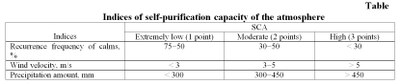
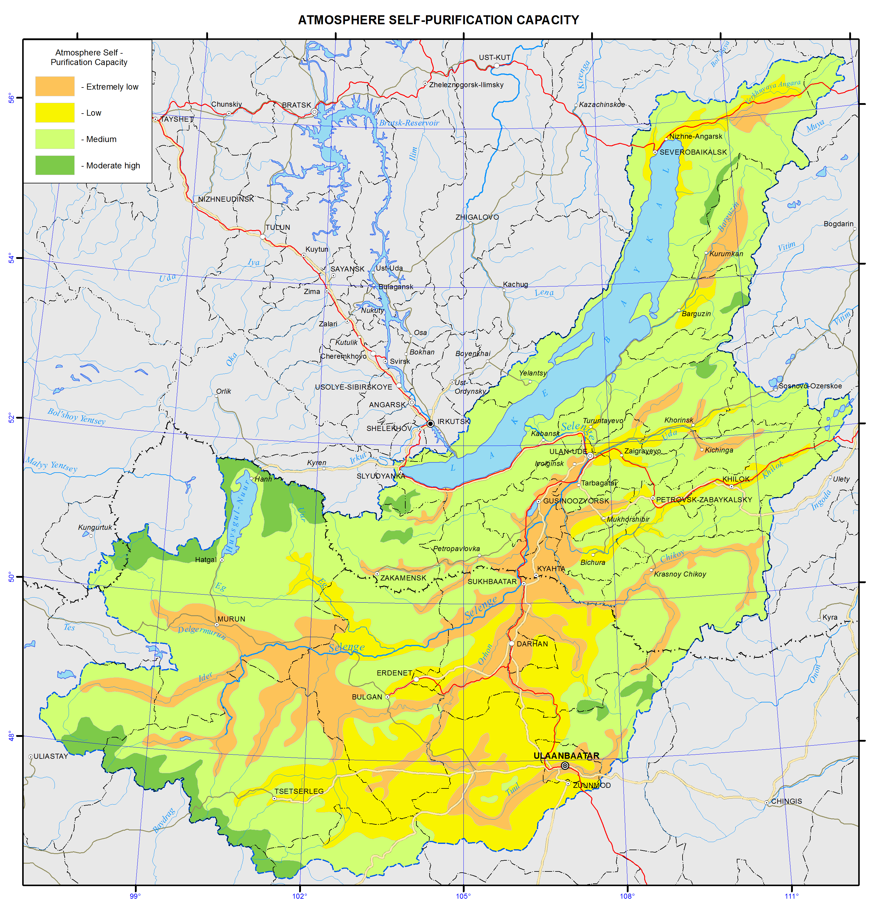
<p>The SCA was assessed following the technique reported by V.V. Kryuchkov [1979] in which it is assumed that almost no self-purification of the atmosphere occurs in the event of the mean annual wind velocity and the recurrence frequency of calms characterizing stagnant phenomena, and with the smallest precipitation amount (<i>table</i>). The SCA manifests itself with an enhancement in wind velocity, a decrease in recurrence frequency of calms, and with an increase in precipitation amounts.</p>
<p>In real situations, the indices show broader combinations. The use of the points-assessment approach makes it possible (by summing up the points of the indices) to take into account the diversity of the existing combinations of SCA: 3−4 points – extremely low, 5 – low, 6−7 – moderate, 8 – moderately high, and 9 – high   [Bashalkhanova et al., 2012]. With reference to the mountain territories, allowance was made for the known regularities inherent in changes of climatic indices depending on the location of orographic systems relative to the main transport of air masses. We assumed that with the slope steepness varying from 6 to 20° and the altitude of the location in the range 1500−2000 m, average conditions are created for the atmosphere’s self-purification. With an increase in slope steepness &gt;20° and with altitudes &gt;2000 m, the probability of a good SCA increases.</p>
<p>What has been outlined above was used in analyzing material reported in thus making it possible to identify in the study area four SCA levels. A moderately high SCA is characteristic for open steep-slope summit planes. A moderate SCA is intrinsic in elevated locations, slope surfaces, and in the shores of Lake Baikal and Lake Khovsgol. On the shores of Lake Baikal, however, Large temperature differences between land and lake contribute to a simultaneous development and superposition of the local forms of circulations, the maximal activity of which occurs in the zone below the height of the surrounding mountain ridges [Lake Baikal Atlas…,1993]. Therefore, here, despite sufficient wind activity (moderate SCA), the removal of pollutants beyond the depressions will be made difficult. A low SCA corresponds to gently rolling interfluves, river valleys, and to the lower parts of slopes. An extremely low SCA is set up in closed intermontane depressions and in the river valleys of the southwestern part of the basin nearby the anticyclone core, and along its periphery – in the areas of river valleys perpendicular to the base flow of air masses.</p>
<p>It should be noted that by taking into consideration the mesoclimatic differences, it is possible to obtain a more differentiated assessment of SCA. It is known that the deviations of the mesoclimatic characteristics from the background ones are most clearly expressed in the wind velocity, temperature and precipitation regimes. Wind velocity change coefficients in various terrain conditions may vary from 0.6 to 2.0 in comparison with the wind velocity at open even spaces [Romanova, 1977; Linevich, Sorokina, 1992], their minimal values are characteristic of the lower parts of slopes, while maximum values are characteristic of the upper parts of windward slopes and peaks. The mesoclimatic differences in moisture conditions are also closely connected with the position of the slopes toward the main air-mass transport, their steepness and character of the geological substate. An increase in the rainfall with the altitude increase and its significant differences on windward and downwind slopes are known.</p>
<p>Furthermore, the seasonal differences in SCA across the study territory will be substantial because of the characteristic features of the atmospheric circulation. Therefore, when planning the siting of production facilities in a particular territory, it is necessary to assess the mesoclimatic potential of SCA.</p>
<p><b> </b></p>
<p align="center">References</p>
<p><i>Lake Baikal Atlas</i>. (1993). Moscow, 160 p.</p>
<p>Bashalkhanova, L.B., Veselova, V.N. and Korytny, L.M. (2012). <i>Resource Dimension of Social Conditions for the Life of the Population of East Siberia</i>, Novosibirsk: Geo, 221 p.</p>
<p>Beresneva, I.A. (2006).<i>The Climates of the Arid Zone of Asia</i>, Moscow: Nauka, 286 p.</p>
<p>Zhadambaa, Sh., (1972). The role of air temperature inversion in the enhancement process of the winter anticyclone over Asia, <i>Trudy GMTs SSSR</i>, issue 109, pp. 89−94</p>
<p>Sevastyanov, V.V., (1998). <i>The Climate of the High Mountain Areas of Altai and Sayans</i>, Tomsk: Izd-vo TGU, 202 p.</p>
<p>Romanova, E.N. <i>The microclimatic variability of the main climatic elements</i>, Leningrad: Gidrometeoizdat, 1977, 279 p.</p>
<p>Kryuchkov, V.V. (1979). <i>The North, Nature and Man</i>, Moscow: Nauka, 127 p. <i> </i></p>
<p>Linevich, N.L., Sorokina, L.P. (1992). The climatic potential of self-purification of the atmosphere: an experience of multi-scale assessment // <i>Geografiya i prirodnye resursy</i>, # 4, pp. 160-165.</p>
<p style="text-align: center; "><img class="image-inline" src="../../../resolveuid/eeea094866c34e6e98f2b029253015d5/@@images/image/preview" /></p>]]></content:encoded>
    <dc:publisher>No publisher</dc:publisher>
    <dc:creator>Alexander Ayurzhanaev</dc:creator>
    <dc:rights></dc:rights>
    <dc:date>2014-10-07T02:45:00Z</dc:date>
    <dc:type>Page</dc:type>
  </item>


  <item rdf:about="http://bic.iwlearn.org/en/atlas/atlas/22-climate-discomfort-map/climate-discomfort-map">
    <title>Climate discomfort map</title>
    <link>http://bic.iwlearn.org/en/atlas/atlas/22-climate-discomfort-map/climate-discomfort-map</link>
    <description></description>
    <content:encoded xmlns:content="http://purl.org/rss/1.0/modules/content/"><![CDATA[<p><img class="image-inline" src="../../../resolveuid/545c13bd05fd47189702e0b54bc5ecaf/@@images/image/preview" /></p>
<p><a href="http://bic.iwlearn.org/en/atlas/photos/copy_of__22_Climatediscomfort.png" class="internal-link">Open full size</a></p>
<p align="center"><strong>Discomfort of climate</strong></p>
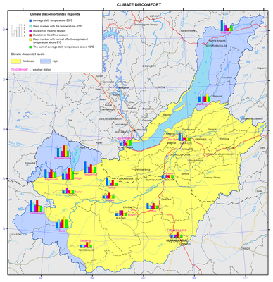
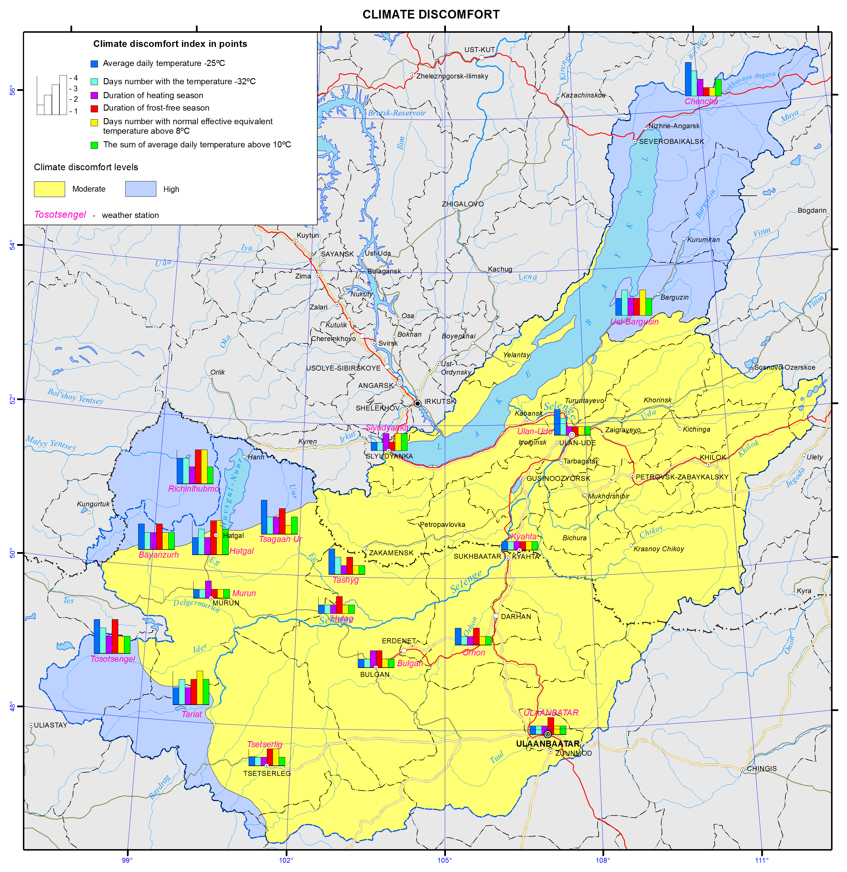
<p>The influence of climate on human beings manifests itself in a variety of fashions, primarily through man’s thermal state governed by external effects as well as by internal physiological processes. A comfortable perception of heat occurs when the input of heat and the thermal discharge in human body are in equilibrium. With an intensification of heat or cold, there is an increase in the tension of the physiological systems, which ensures this equilibrium. The intensity and duration of the impact from significant environmental parameters are responsible for the level of expenditures connected with the attainment of physiological comfort of the human life.</p>
<p>The number of days with normal-equivalent-effective temperature (NEET) above 8 °C is said to characterize indirectly the degree of comfort of a warm period for sensibly dressed people. The duration of periods with daily mean air temperatures below −25 °C and the sums above 10 °C represent the territory’s resources of heat and cold. The contrasts of the frost-free period determine the need for and the reliability of covering materials used in vegetable farming. In addition, a combination of low temperatures with wind velocity acts to enhance   heat output from open surfaces of human body. The risk of cold weather injuries when the values of reduced temperatures are below −32 °C serves as a forewarning in the case of arranging recreation and working in the open air [Khairullin and Karpenko, 2005]. The duration of the heating period makes it possible to calculate the future expenditures of heat necessary for heating various premises.</p>
<p>The spatial differentiation of the indices under consideration is important within the confines of the basin [Scientific-applied…, 1989, 1991; <a href="http://www.meteo.ru/">http://www.meteo.ru</a>]. The mean daily temperature in the high mountains does not reach 10 °C, and its sum varies from 2400 °С in the southern part of the basin to 500 °С along the northeastern shores of Lake Baikal. The mean monthly NEET do not reach 8 °C in separate sections of the shores of Khovsgol and Baikal, and across the remaining territory they vary from 40 to 110 days. The frost-free period varies between 0 to 110 days. The smallest spatial fluctuations correspond to the duration of the heating season (230−305 days). The number of days with the mean daily air temperature below −25 °C is largest in the bottoms of closed depressions and valleys of the western part of the basin. With the wind factor taken into account, the differentiation of the severity of climate is enhanced. The mean values of reduced January temperature drop below −37 °C in Tosontsengel and Khatgal. In the former case, this is due to low air temperatures, whereas the increased wind activity is responsible for this in the latter case.</p>
<p>The combined effect of climatic resources has a substantial influence upon the aggregate volume of expenditures connected with the provision of physiological comfort for humans and the manufacture of products. The background characteristic features of the combined effect of the meteoparameters under consideration on humans and of their duration upon the degree of discomfort of habitation were revealed by using the resource-assessment approach [Bashalkhanova et al., 2012].</p>
<p>Throughout most of the basin’s territory the level of climatic discomfort is moderate, whereas it is strong on the northern, northwestern and western margins. The circle diagrams show the volume of the most differentiated parameters of climatic discomfort. The vertical axis is graduated in points from 1 to 5, and reflects the conditions of warm and cold periods. The diagrams corresponding to the most contrasting locations display the leading attributes of climatic discomfort of these territories.</p>
<p>A strong level of discomfort in the northern and western parts of the basin is due largely to the preceding low air temperatures, while on the shores of Khovsgol and in Tariat it is, to a larger extent, caused by a low heat availability in the summertime and, in the aggregate, by increased wind activity. The life of the population on such territories is more expensive and involves a limitation of the kinds of economic activities, shorter periods of stay in the open air, the requirement for a higher energy value of food, heat insulation of clothes and rooms, and a necessitous adjustment of production technologies, equipment and systems to low temperatures. On the other territory, the total duration of impacts of the parameters under consideration lies within moderate limits. The low duration of the period with NEET &lt;5 °C (within 40−70 days) in the middle mountains is compensated by favorable winter conditions.</p>
<p><b> </b></p>
<p align="center">References</p>
<p>Bashalkhanova, L.B., Veselova, V.N. and Korytny, L.M., (2012). <i>Resource Dimension of Social Conditions for the Life of the Population of East Siberia</i>, Novosibirsk: Geo, 221 p.</p>
<p><i>Scientific-Applied Handbook on the USSR Climate</i>. Ser. 3, Long-Term Data, Parts 1−6, (1989). Leningrad: Gidrometeoizdat, 1991, issue 22, 604 p.;, issue 23, 550 p.</p>
<p>Khairullin, K.Sh. and Karpenko, V.N., (2005). Bioclimatic resources of Russia, in <i>Climatic Reources and Methods of Representing Them for Applied Purposes</i>, St. Petersburg: Gidrometeoizdat, pp. 25−46 <i> </i></p>
<p><i>VNIIGMI-WDC Data Archives</i>. Retrieved from: <a href="http://www.meteo.ru/">http://www.meteo.ru</a></p>]]></content:encoded>
    <dc:publisher>No publisher</dc:publisher>
    <dc:creator>Alexander Ayurzhanaev</dc:creator>
    <dc:rights></dc:rights>
    <dc:date>2014-10-07T02:40:00Z</dc:date>
    <dc:type>Page</dc:type>
  </item>


  <item rdf:about="http://bic.iwlearn.org/en/atlas/atlas/06-geology-map/geology-map">
    <title>006. Geology map</title>
    <link>http://bic.iwlearn.org/en/atlas/atlas/06-geology-map/geology-map</link>
    <description></description>
    <content:encoded xmlns:content="http://purl.org/rss/1.0/modules/content/"><![CDATA[<p><img class="image-inline" src="../../../resolveuid/3b2a087fe66e4f55a4b768dc954b0152/@@images/image/preview" /></p>
<p><span><a href="http://bic.iwlearn.org/en/photos/copy2_of__06_Geology.png" class="internal-link">Open full size</a></span></p>
<p><span> </span><img class="image-inline" src="../../../resolveuid/368b7708f6054d33a4ec7c0d8142a5b2/@@images/image/preview" /></p>
<p><a href="http://bic.iwlearn.org/en/atlas/photos/copy_of__06_Geology_Legend.png" class="internal-link">Open full size</a></p>
<p align="center"><strong><strong>Geological structure</strong></strong></p>
<p align="center"><strong> </strong></p>
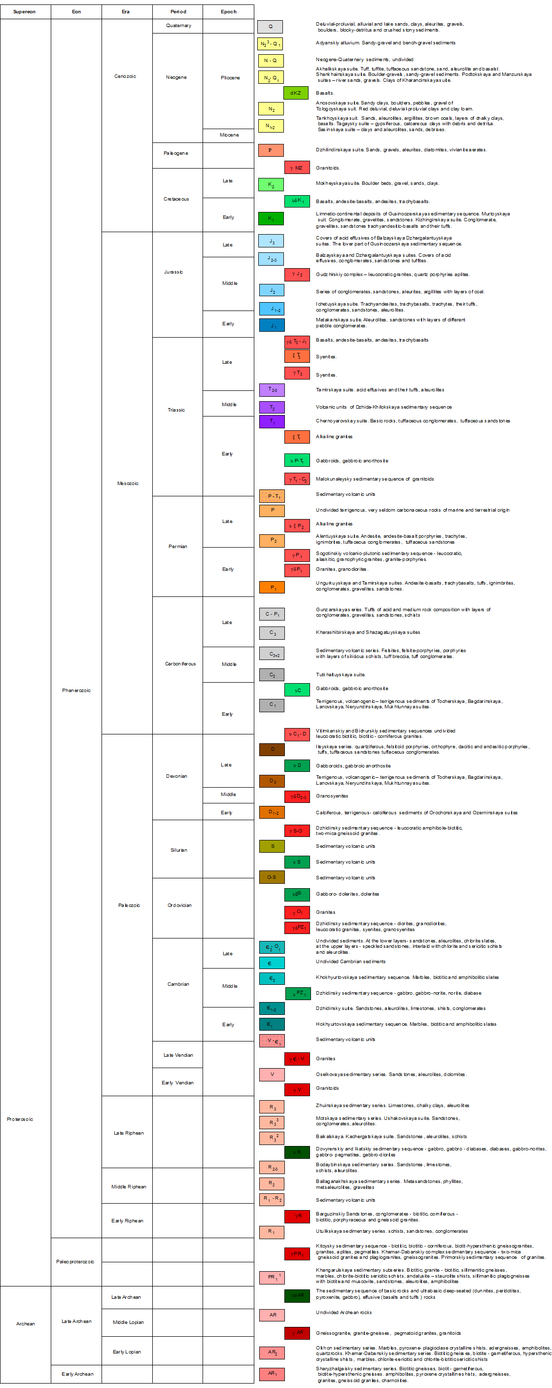
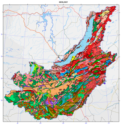
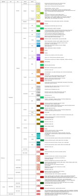
<p class="1" style="text-align: justify; ">Many features inherent in the geological structure of the territory of the watershed basin are due to the fact that the territory lies at the interface between the two main lithospheric plates of East Siberia, namely the old Siberian platform, and the younger Central-Asian mobile belt. Formation of the geological structure of both Russian and Mongolian parts of the territory began in the Early Precambrian. For this reason, the geological structures, presented on the map, preserved traces of both Precambrian and Phanerozoic eras of tectogenesis.</p>
<p class="1" style="text-align: justify; ">Precambrian formations have been ascertained essentially within the mountain framing of the Baikal hollow and to the south and south-west of it, within the north-west of Mongolia.</p>
<p class="1" style="text-align: justify; ">The Precambrian sedimentary-metamorphic complexes within the mountain framing of the Baikal hollow, presumably of Archean age, are separated into three series differing in the set of rocks building them up, the degree of metamorphism, the type of magmatic manifestations, and the pattern of fold structures: the Sharyzhalgai, Khamar-Daban and Olkhon series. The occurrence area of rocks of the Sharyzhalgai series in the south is clearly delineated – it is a near-rectilinear shore of Lake Baikal between the source of the Angara river and the settlement of Kultuk, and in the south-west – by the zone of the Main Sayan Fault. Its composition includes rocks of two types: biotite, biotite-garnet and biotite-hypersthene migmatizated gneisses among which there occur, in the form of separate interlayers and thicker bedsets, amphibolites, pyroxene and amphibolite-pyroxene schists as well as granites differing in composition and structural-textural characteristics. The complex of sedimentary-metamorphic formations of the Khamar-Daban series is of widespread occurrence along the southern shores of Lake Baikal and within the confines of the Khamar-Daban mountain range. The composition of the series is notable for the Slyudyanka and Kharangul subseries. The Slyudyanka subseries is comprised of thick terrigenous-carbonate layers (carbonate bedsets, and specific silicious-dolomite apatite-bearing rocks), while the Kharangul subseries is dominated by flyschoid deposits (aluminous slates, and gneisses with rarely occurring interlayers and bedsets of carbonates). Deposits of the Olkhon series occur widely in Priolkhonie and on Olkhon Island; they are represented by marbles, pyroxene-plagioclase crystalline schists, amphibole-biotite gneisses, and magmatites with interbeds of amphibolites and quartzites. The Precambrian ophiolitic complex, confined to the suture zones of the fold belt, is registered in the north-western part of Mongolia.</p>
<p style="text-align: justify; ">The Lower-Proterozoic deposits of the Muya series are exposed on the watersheds of the Primorskii ridge along the coastal stripe of Maloe More and are represented by quartzites, slates and metamorphized effusives.</p>
<p style="text-align: justify; ">The Upper-Proterozoic (Riphean) deposits occur mainly within the Baikal mountain region. The Patom series occurs in the north of the region and divides into the Ballaganakh, Kadalikan and Bodaibo subseries which, in turn, subdivide into formations. In Western Cisbaikalia there occurs the Baikal series of the Upper Proterozoic consisting of three formations: the Goloustnoe, Uluntui and Kachergat formations. In the south, within the Olkha−Goloustnoe plateau there occur deposits of the Ushakovka formation of the Moty series.</p>
<p style="text-align: justify; ">Cambrian rocks occur widely in the Middle-Vitim, Angara-Barguzin, and Khamar-Daban mountain regions as well as in the mountain framing of Lake Khovsgol, and within the Uda river basin. The composition of Cambrian deposits is quite varied, ranging from conglomerates and sandstones to very fine carbonate differences. The Devonian deposits are represented by a rather broad spectrum of separate isolated areas; they are arbitrarily subdivided into two stratigraphic complexes. The lower Devonian layers are dominated by carbonate deposits, while the upper level is comprised of terrigenous and volcanogenic-terrigenous deposits. The Carboniferous deposits occur in many isolated areas.  The Carboniferous is represented largely by terrigenous marine deposits (sandstones, aleurites, gravelites, conglomerates, and slates). The Permian deposits are also extremely isolated. The largest field of Permian deposits is the Borzya deposit; it lies in Eastern Transbaikalia, and in Western Transbaikalia in the Khilok area. They are represented by relatively uniform terrigenous (and very rarely, carbonate) rocks of a marine and continental origin.</p>
<p style="text-align: justify; ">The Triassic deposits include widely occurring volcanogenic formations that are assigned to the Dzhida-Khilok series occurring with scouring on Paleozoic granitoids and other rocks. The lower layers are comprised of the Chernoyarovo formation consisting of major effusives, tuff conglomerates and tuff sandstones. The upper layers include the Tamirskaya formation consisting of acid effusives and their tuffs, and aleurites. Sedimentary and sedimentary-volcanic deposits of the Triassic occupy large areas in the western part of Mongolia, where they are interrupted in some places by the Jurassic sediments. The Lower-Jurassic formations are dominant in the eastern part of Transbaikalia, while marine deposits of the Lower- and partially Mid-Jurassic period are found only in the central part of Eastern Transbaikalia. In the north-west and south-east marine deposits are replaced by continental formations. Starting largely in the Mid-Jurassic period, the western and northern parts of Transbaikalia had been accumulating layers of conglomerates, sandstones, aleurites and argillites with interbeds of bituminous coal. The upper division includes covers of acid effusives. Such effusive-sedimentary formations also extend over the Vitim upland. The syncline cores, usually with their north-eastward strike line, occur in the area of Cretaceous freshwater-continental deposits. The lower part of these deposits refers to the Jurassic, while the upper part corresponds to the Cretaceous. The lower Cretaceous layers are comprised of conglomerates, sandstones, aleurites, slates and strata of brown coal, whereas the upper layers include boulder beds, shingle, sands and clays of the Mokheiskaya formation. In the central parts of Mongolia Cretaceous deposits are somewhat controlled spatially by deep faults and unconformably lie on the Devonian and Cambrian deposits.</p>
<p style="text-align: justify; ">Paleogene deposits occur very fragmentarily and are most commonly regarded as Upper Cretaceous−Paleogene deposits, because their detailed partition is unfeasible to date.  They are represented by covers of red and variegated-red clays, sandy-shingle deposits and lacustrine clays. Paleogene deposits are characterized by successive link of their composition with the laterite-kaolinite weathering crust. Miocene deposits of the Tankhoi formation are of widespread occurrence on the south-eastern shore of the lake; they were also found at different depths in the course of drilling in the sediments of the Ust-Selenginskaya depression, within the Barguzinskaya depression, and in intermountain depressions of Northern Pribaikalie. In the Dzhida mountainous area and on the Khamar-Daban range, basalt covers, overlaying the watershed areas, belong to the Miocene. On Olkhon Island, deposits of the Tagai formation, which are overlapped with an angular unconformity by deposits of the Sasinskaya formation (Upper Miocene - Lower Pliocene), are referred to the Lower-Middle Miocene. The Upper Pliocene and Eo-pleistocene in most cases compose a single rock mass, which resists dissection. Deposits of this age are registered in South Baikal (Shankhaikhinskaya formation), and in a number of areas of the eastern, western and southern surrounding of the Baikal hollow. On Olkhon Island the Upper Pliocene is represented by clays of the Kharantsy formation. Quaternary formations are characterized by a diversity of lithogenetic and facial types and occupy different geomorphological positions. Most often, the lower half of the profile of the quaternary system clearly shows a thick, complicated sandy layer, while the upper layers of the Pleistocene and Holocene are dominated by rudaceous deposits, including morainic.</p>
<p style="text-align: justify; ">The Siberian block of the Eurasian plate and adjoining spaces which, as a result of a long-lasting development, had transformed to the Sayan-Baikal orogenic belt, were characterized by the differing trends of geological events.</p>
<p style="text-align: justify; ">In the Early Precambrian, the sialic masses that merged together to form a single block, i.e. Siberia, comprised several Archean blocks with the well-developed continental crust. They were separated by proto-oceanic basins. Toward the end of the Early Proterozoic, the proto-continental blocks had formed a massif with a mature continental crust, i.e. a basement of the Siberian platform. As a result of the Early-Proterozoic orogeny, the marginal zone of the continent developed the mountain terrain which had been destroyed by the beginning of the Riphean. The Mid-Riphean stage started to accumulate the proper sedimentary cover of the Siberian platform. At the close of the Riphean−Vendian time, most of the paleocontinent was covered by the sea. On the other hand, orogenic movements resulted in the formation of elevated blocks of the Barguzin and Bokson−Khovsgol microcontinents. They produced a discontinuous chain of mountain ridges separating the Siberia paleocontinent from the Paleo-Asian Ocean. In the late Vendian−early Cambrian, the mountain massifs underwent substantial planation. Starting in the early Cambrian and during the Ordovician−Silurian, the eastern and southern margins of the basements of the microcontinents were represented by shelf zones, and by the upper parts of the continental slope of the oceanic basin. In the latter half of the early Paleozoic and at the beginning of the late Paleozoic, the collision of the Barguzin microcontinent with the Siberian platform triggered the formation of Barguzin granitoids. The latter half of the Paleozoic witnessed the collision of the Barguzin, Bokson-Khovsgol and other microcontinents with the margin of the Siberia paleocontinent. The Paleo-Asian Ocean stretched out southward of the Siberia paleocontinent. In the Hercynian era, the active processes in the Mongol−Okhotsk belt were responsible for the tectonic-magmatic intensification of the Sayan-Baikal region and the southern part of the Siberian platform. At the beginning of the Mesozoic, an attenuation of the vertical tectonic movements led to peneplanation with the formation of a thick weathering crust. The subsequent Mesozoic intensification was responsible for a growth of the mountains in the Sayan-Baikal region, and for an intensification of intrusive magmatism.</p>
<p style="text-align: justify; ">The end of the Cretaceous−Paleogene was marked by a long-lasting period of peneplanation and crust formation which preceded directly the Cenozoic riftogenesis and the formation of the morphostructural plan of the Baikal Rift Zone and the Baikal basin.</p>
<p style="text-align: justify; ">The distinguished tectonic stages are very clearly registered in three tectonic blocks in the territory of Mongolia, namely: western – Caledonian; central – Early Caledonian, with numerous outthrusts of rocks of the crystalline basement and Hercynian and Mesozoic structures overlaying them, and southern – Hercynian. In general, the modern overlapped-folded structure of the Mongolian territory outlines certain spatial and temporal patterns, consisting in a directional change of more ancient structures, located in the north and west, by younger ones, clearly manifested in the south.</p>
<p style="text-align: justify; ">The territory of the the Baikal basin is unique as regards the occurrence, range and diversity of granitoids, which occupy more than 70% of the area, while the formation of acid magmas was taking place from the Archean to the early Cretaceous. They tend to occur within the Mongol−Okhotsk (Mongol-Transbaikalian) mobile belt, having a complex long-lasting history. The following stages of magmatism are identified:</p>
<p style="text-align: justify; ">1. Archean early-orogenic – formation of migmatites and lenticular concordant bodies of gneissogranites and granites. Archean late-orogenic – intrusive bodies of pink and red leucocratic significantly potassic granites and alaskites.</p>
<p style="text-align: justify; ">2. Early Proterozoic late-orogenic fissure intrusions of the seaside granite complex.</p>
<p style="text-align: justify; ">3. Late Baikalian−early Caledonian (Vendian−early Cambrian) – basic volcanism, ultrabasic intrusions.</p>
<p style="text-align: justify; ">4. Late Caledonian (Cambrian−Silurian) – formation of granitoids on a mass scale.</p>
<p style="text-align: justify; ">5. Early Hercynian (Devonian) – local occurrence of acid and mixed volcanism. Intrusions of alkali-earth syenites, granites, and alaskite granites.</p>
<p style="text-align: justify; ">6. Late Hercynian (Carboniferous−Permian) – intrusive series of gabbro-monzonite-syenite, alkali-syenite and alkali-granite composition.</p>
<p style="text-align: justify; "><a href="http://dic.academic.ru/dic.nsf/ruwiki/1261431">7. Triassic−Cretaceous</a> – series of tectono-magma activations with the establishment of volcano-tectonic structures, formation of intrusions of normal and alkali-earth granodiorite−leucogranite series and effusion of basaltoids.</p>
<p style="text-align: justify; ">8. Quaternary period – riftogenesis and effusion of alkali basaltoids.</p>]]></content:encoded>
    <dc:publisher>No publisher</dc:publisher>
    <dc:creator>Alexander Ayurzhanaev</dc:creator>
    <dc:rights></dc:rights>
    <dc:date>2014-10-07T02:00:00Z</dc:date>
    <dc:type>Page</dc:type>
  </item>


  <item rdf:about="http://bic.iwlearn.org/en/atlas/atlas/82-tourism-map/tourism-map">
    <title>Tourism map</title>
    <link>http://bic.iwlearn.org/en/atlas/atlas/82-tourism-map/tourism-map</link>
    <description></description>
    <content:encoded xmlns:content="http://purl.org/rss/1.0/modules/content/"><![CDATA[<p><img class="image-inline" src="../../../resolveuid/b05baa84669049b9888661f593b652bd/@@images/image/preview" /></p>
<p><a href="http://bic.iwlearn.org/en/atlas/photos/copy_of__82_Tourism.png" class="internal-link">Open full size</a></p>
<p align="center"><strong>Tourism</strong></p>
<p align="center"><strong> </strong></p>
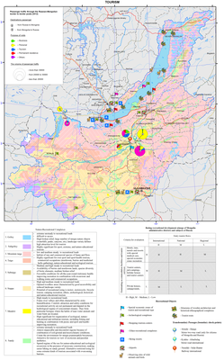
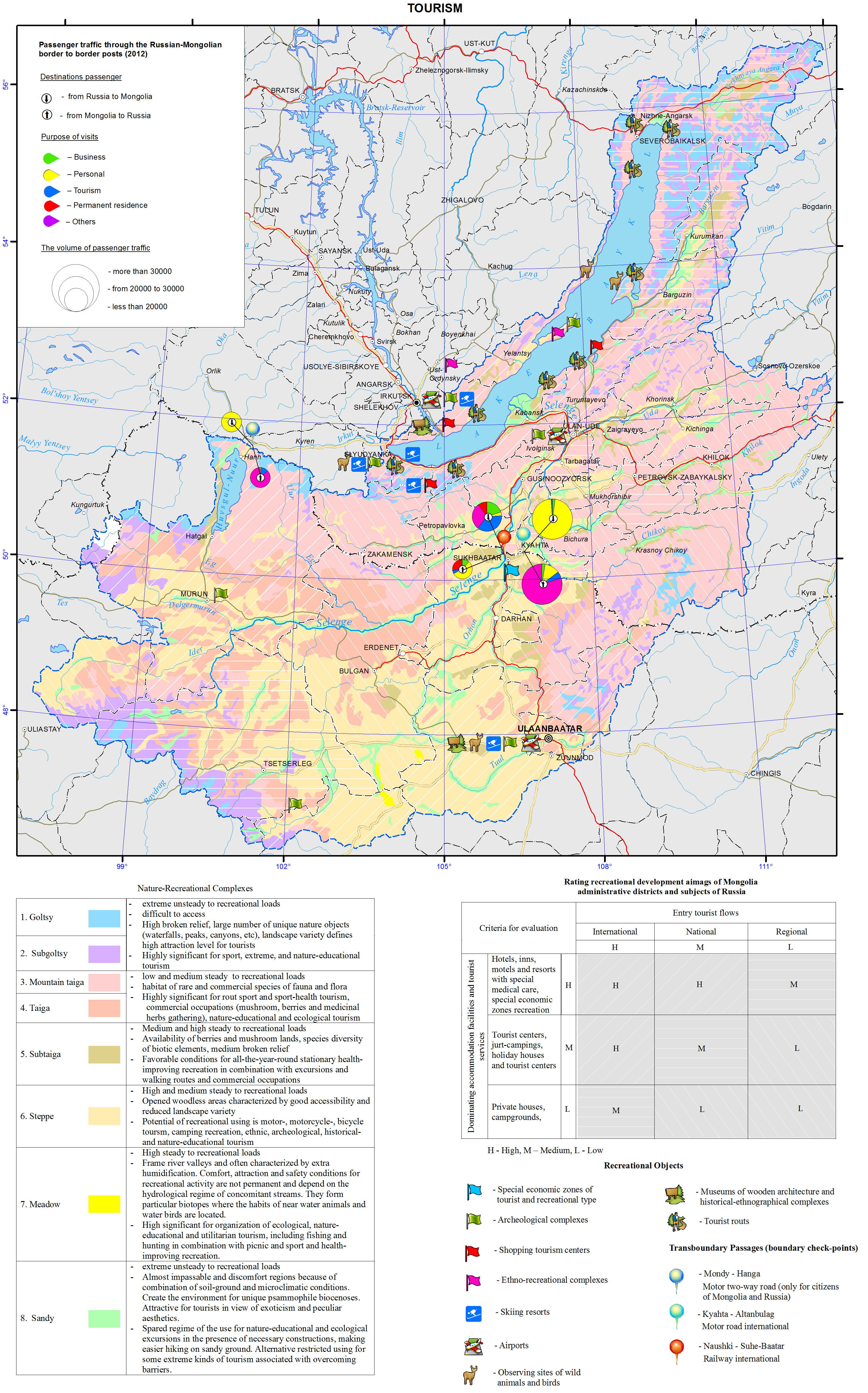
<p>The Baikal basin is a unique area that draws attention of tourists from all over the world. Its location in the heart of the Eurasian landmass has defined its high ethno-cultural and natural diversity. The history of development of the lands around Baikal is connected with the rise of two giant empires – Mongolian and Russian, as well as with the historical development of trade and transport routes.</p>
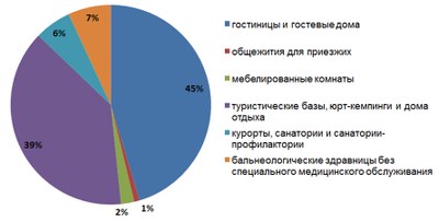
<p>The natural and resource nucleus of the recreational system of the Baikal basin is the oldest and deepest lake in the world itself. Infrastructural centers for tourism development are major cities of Ulaanbaatar, Irkutsk, and Ulan-Ude. They play the role of major international transport hubs and have administrative, educational, and cultural tourism resources, as well as a significant hospitality potential. In 2012, Ulaanbaatar had the largest hotel fund (over 170 hotels). There were about 80 hotels in Irkutsk and up to 20 in Ulan-Ude. In general, the transboundary area of the Baikal basin has over a thousand places for tourist accommodation of general and special purpose (Fig. 1).</p>
<p style="text-align: center; "><img class="image-inline" src="../../../resolveuid/e1da5a0a1de942da8b51036648fbd2bb/@@images/image/preview" /></p>
<ul>
<li>hotels and guest houses </li>
<li>hostel for visitors </li>
<li>hostels, yurt camping and rest houses </li>
<li>resorts, motels and sanatorium </li>
<li>balneologic resorts without special health care</li>
</ul>
<p style="text-align: justify; "><b>Figure 1. Recreational accommodation facilities in the transboundary Baikal basin [Business of the Angara region…, 2012; Activities of tourism firms..., 2011; Culture, tourism, and recreation…, 2012; Tourism in Sunny Buryatia, 2011; Soyol ..., 2013]</b></p>
<p>The number of accommodation facilities, as well as the level of offered services in conjunction with the configuration and nature of the tourist traffic help identify the most important areas for the tourism industry, assess the degree of tourism development, and get a general picture of a territorial structure of recreational activities. A matrix integrating the character of tourist traffic and a predominant type of accommodation was used as the basis for the expert assessment of tourism development of administrative units of Russia and Mongolia.</p>
<p>The main distinctive characteristics of the recreational system of the Baikal basin is its transboundary position. Therefore, the neighboring aimags of Mongolia and administrative districts of Irkutsk oblast and the Republic of Buryatia that are located along the state border and have cross-border corridors (ports of entry) are of a special significance.</p>
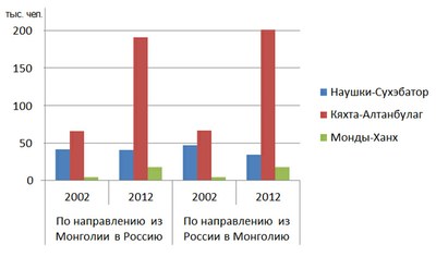
<p>The process of development of cross-border tourism in the neighboring territories of Russia and Mongolia is taking place under conditions, where both countries with a unique culture and nature are an integral part of the international recreational space, have a special interest for tourists from other countries, and make mutual contribution to the formation of the inbound tourist traffic. The Russian-Mongolian border, which crosses the basin, has three checkpoints that not only facilitate the exchange of foreign and domestic tour groups, but also serve as a prerequisite for the development of cross-border trade. Within 10 years, the total volume of passenger traffic through the existing checkpoints has more than doubled – from 229 thousand people in 2002 to 502.5 thousand people in 2012 (Fig. 2).</p>
<p style="text-align: center; "><img class="image-inline" src="../../../resolveuid/1c774d490c45475d9df1908773c75d9d/@@images/image/preview" /></p>
<p align="center"> </p>
<ul>
<li>Naushki-Sükhbaatar</li>
<li>Kyakhta-Altabulag</li>
<li>Mondy-Khankh</li>
</ul>
<p style="text-align: justify; "><b>Figure 2. Passenger traffic through the Russian-Mongolian border [Mongolian..., 2013; Mongolian ..., 2006]</b></p>
<p>Development of cross-border tourism requires joint decisions to promote a common tourism product on the state level. Such projects as “Baikal-Khovsgol”, which connects two great lakes of Asia, and “The Tea Road” have already become popular. The establishment of transboundary special protected areas have great prospects for the bilateral cooperation in the field of eco-tourism. They represent a particular organizational resource, which is important not only for the resolution of shared environmental problems, but also for the coordination of efforts aimed at implementing cross-border tourism projects.</p>
<p>Active cooperation between Russia and Mongolia in promoting tourism within the unique natural object – the Baikal basin not only opens the possibilities for increasing inbound foreign tourism in both countries, but also contributes to the expansion of similar relationships with other neighboring countries, such as China, Kazakhstan, and Japan.</p>
<p> </p>
<p align="center">References</p>
<p>Statistical Compendium. (2012). <i>Business of the Angara region: Tourism and hospitality</i>. Irkutsk: Irkutskstat. p 35-62.</p>
<p>Statistical Compendium. (2011). <i>Activities of tourism firms and collective accommodation facilities in the Republic of Buryatia in 2011</i>. Ulan-Ude: Buryatstat. p 7-12.</p>
<p>Statistical Compendium. (2012). <i>Culture, tourism, and recreation in the Angara region</i>. Irkutsk: Irkutskstat. p 45-52.</p>
<p>Statistical Compendium. (2011). <i>Tourism in Sunny Buryatia</i>. Ulan-Ude: Buryatstat. p 59.</p>
<p>National Statistical Office of Mongolia. (2013). <i>Soyol, sport, ayalal, zhuulchlalyn salbaryn lavlakh</i>. Ulaanbaatar. p 285.</p>
<p>National Statistical Office of Mongolia. (2012). <i>Mongolian statistical yearbook 2012</i>. Ulaanbaatar. p 297-299.</p>
<p>National Statistical Office of Mongolia. (2007). <i>Mongolian statistical yearbook 2006</i>. Ulaanbaatar. p 265-269.</p>]]></content:encoded>
    <dc:publisher>No publisher</dc:publisher>
    <dc:creator>Alexander Ayurzhanaev</dc:creator>
    <dc:rights></dc:rights>
    <dc:date>2014-10-07T00:56:13Z</dc:date>
    <dc:type>Page</dc:type>
  </item>


  <item rdf:about="http://bic.iwlearn.org/en/atlas/atlas/28-maximum-runoff-during-the-flood-map/maximum-runoff-during-the-flood-map">
    <title>Maximum runoff during the flood map</title>
    <link>http://bic.iwlearn.org/en/atlas/atlas/28-maximum-runoff-during-the-flood-map/maximum-runoff-during-the-flood-map</link>
    <description></description>
    <content:encoded xmlns:content="http://purl.org/rss/1.0/modules/content/"><![CDATA[<p><img class="image-inline" src="../../../resolveuid/7e21331f5819408badfa79e4240cb100/@@images/image/preview" /></p>
<p><a href="http://bic.iwlearn.org/en/atlas/photos/copy_of__28_Maximumrunoffduringtheflood.png" class="internal-link">Open full size</a></p>
<p align="center"><strong>Flow</strong></p>
<p>The map “Mean annual flow” reflects the formation patterns of the water regime of the territory, which are determined by the properties of landscapes to transform atmospheric moisture into the runoff.</p>
<p>For a water body basin, the surface runoff is the total amount of water loss from the watershed landscapes. The runoff rate from landscape complexes is determined by solving the inverse problem, i.e. identification of the connection of flow rate at the main stream station of a catchment with the runoff from landscapes, occupying its area, and is calculated based on the equation Q<sub>j</sub> = ∑q<sub>i</sub> f<sub>ij</sub><i>,</i><i> </i>where <i>j</i> is the index of the river basin, Q<sub>j</sub> is its runoff, L/s; q<sub>i</sub> is a modification of flow from the i-th landscape complex, L/s km<sup>2</sup>; f<sub>ij</sub> is an area of the j-th basin occupied by the i-th landscape, km<sup>2</sup>. Long-term average runoff data for small and medium-sized rivers of theLake Baikal basin were used in calculations for the map construction [Long-term…, 1986, http://www.r-arcticnet.sr.unh.edu]. Characteristics of landscape components were obtained on the basis of the materials on landscape of the Baikal region [Landscapes…, 1977, Natural..., 2009, Landscapes…, 1990, Lysanova et al., 2009]. In accordance with the regional dimension, generalization degree is chosen at the geom level, and their average annual flow moduli are determined. The territory on the map is divided into regions according to five gradations of the module - from less than 1 to more than 10 L/s km<sup>2</sup>.</p>
<p>The catchment area of the lake covers a variety of landscape zones and altitudinal belts, which makes a great contrast between the runoff rates. The highest annual flow moduli are formed within the goletz and mountain-taiga landscapes. Steppe and forest-steppe areas are distinguished by the minimum runoff rates, and in the desert regions of Mongolia (the Selenga river basin) flow formation almost does not take place.</p>
<p>The maps of minimum and maximum flow were compiled based on the typological landscape classification represented on the map [Landscapes…, 1977]. In the course of investigation, landscapes of different types were generalized by identifying the most hydrologically informative properties (morphological characteristics, vegetation structure, altitudinal zonation, etc.). As a result, more than 200 landscapes were combined into sixteen types of natural complexes, and runoff rates were determined for them. The moduli of maximum snow runoff and minimum summer runoff were calculated as described above.</p>
<p>Areas with the highest runoff of floods are confined to the mountain ranges and systems with goletz open woodlands and mountain-taiga landscapes. The main areas, distinguished by formation of frequent and high floods are the Baikalsky Range on the north-eastern end of the lake; Barguzinsky Range, located in the south-eastern part of the catchment, and the Khamar-Daban, covering the south-western shore of Lake Baikal. The values of the maximum flow modification are shown in three gradations on the map, namely: less than 25, 25-70, and more than 100 L/s km<sup>2</sup>.</p>
<p>Features of formation of the minimum summer runoff in the Baikal basin are associated with the regime of atmospheric moisture, as well as with the effects of altitude and exposition. The calculations and analysis of the minimum summer runoff have shown a relatively high water yield in the low-flow period from high-mountain taiga landscapes and extremely low river flow formation in the central areas of the Selenga river catchment and in Priolkhonie, which are covered with light coniferous landscapes and steppe complexes on slopes and plains. The map shows the value of the minimum flow in three gradations, namely: less than 1.5, 3.0-5.0, and more than 5.0 L/s km<sup>2</sup>.</p>
<p>Landscape-hydrological mapping based on the quantitative characteristics of water yield of landscape complexes objectively reflects the hydrological organization of the territory.</p>
<p><b> </b></p>
<p align="center">References</p>
<p>Kuznetsova T.I. (2009). Map "Natural landscapes of the Baikal region and their use: purpose, structure, and content”.  T.I. Kuznetsova, A.R. Batuev, and A.V. Bardash. <i>Geodeziya i kartografiya,</i> , no 9, pp. 18-28.</p>
<p>Landscapes of southern East Siberia [Maps]: [physical map] (1977) / compiled and prep. for printing by factory no. 4 GUGK in 1976, authors: V.S. Mikheev and V.A. Ryashin. 1: 1 500 000, Moscow: GUGK, 1 map (4 sheets): col.</p>
<p>Landscapes [Maps] [physical map] / The National Atlas of the Mongolian People's Republic. / comp .and prep to print by GUGK in 1989, authors: B.M. Ishmuratov, K.N. Misevich, I.L. Savelyeva, et al.</p>
<p>Lysanova, G.I., Semenov, Yu.M., Shekhovtsov, A.I., and Sorokovoy, A.A. (2013). Geosystems of the Republic of Tuva. <i>Geografiya i prirodnye resursy</i>, no. 3, pp. 181-185.</p>
<p>Long-term data on the regime and surface water resources. The Baikal basin. (1986). Vol. 1, no. 14, Leningrad: Gidrometeoizdat, 361 p.</p>
<p><b><i>A Regional, Electronic, Hydrographic Data Network For the Arctic Region.</i></b> <b>URL: </b><a href="http://www.r-arcticnet.sr.unh.edu/"><b>http://www.r-arcticnet.sr.unh.edu</b></a></p>]]></content:encoded>
    <dc:publisher>No publisher</dc:publisher>
    <dc:creator>Alexander Ayurzhanaev</dc:creator>
    <dc:rights></dc:rights>
    <dc:date>2014-10-06T04:20:00Z</dc:date>
    <dc:type>Page</dc:type>
  </item>


  <item rdf:about="http://bic.iwlearn.org/en/friends/mongolian/ngo-network-report">
    <title>NGO network report</title>
    <link>http://bic.iwlearn.org/en/friends/mongolian/ngo-network-report</link>
    <description></description>
    
    <dc:publisher>No publisher</dc:publisher>
    <dc:creator>silbi_747@yahoo.com</dc:creator>
    <dc:rights></dc:rights>
    <dc:date>2014-09-02T08:27:28Z</dc:date>
    <dc:type>File</dc:type>
  </item>


  <item rdf:about="http://bic.iwlearn.org/en/documents/documents/papers/Geoinformational%20of%20Monitoring%20of%20Natural%20Landscape%20Baikal%20Basin%20-english.pdf">
    <title>Geoinformational support of monitoring of natural landscape transformation in the basin of lake Baikal on the basis of retrospective cartographic materials (english).</title>
    <link>http://bic.iwlearn.org/en/documents/documents/papers/Geoinformational%20of%20Monitoring%20of%20Natural%20Landscape%20Baikal%20Basin%20-english.pdf</link>
    <description></description>
    
    <dc:publisher>No publisher</dc:publisher>
    <dc:creator>Alexander Ayurzhanaev</dc:creator>
    <dc:rights></dc:rights>
    <dc:date>2014-04-15T00:50:12Z</dc:date>
    <dc:type>File</dc:type>
  </item>


  <item rdf:about="http://bic.iwlearn.org/en/documents/documents/papers/Spatio-temporal%20dynamics%20of%20vegetation%20cover%20of%20arid%20and%20semiarid%20climatic%20zones%20in%20central%20Mongolia%20on%20the%20basis%20of%20time%20series%20NDVI%20and%20field%20studies%20-rus.pdf">
    <title>Spatio-temporal dynamics of vegetation cover of arid and semiarid climatic zones in central Mongolia on the basis of time series NDVI and field studies (rus).</title>
    <link>http://bic.iwlearn.org/en/documents/documents/papers/Spatio-temporal%20dynamics%20of%20vegetation%20cover%20of%20arid%20and%20semiarid%20climatic%20zones%20in%20central%20Mongolia%20on%20the%20basis%20of%20time%20series%20NDVI%20and%20field%20studies%20-rus.pdf</link>
    <description></description>
    
    <dc:publisher>No publisher</dc:publisher>
    <dc:creator>Alexander Ayurzhanaev</dc:creator>
    <dc:rights></dc:rights>
    <dc:date>2014-04-11T06:20:00Z</dc:date>
    <dc:type>File</dc:type>
  </item>


</rdf:RDF>