<?xml version="1.0" encoding="utf-8" ?>
<rdf:RDF xmlns:rdf="http://www.w3.org/1999/02/22-rdf-syntax-ns#" xmlns:dc="http://purl.org/dc/elements/1.1/" xmlns:syn="http://purl.org/rss/1.0/modules/syndication/" xmlns="http://purl.org/rss/1.0/">


<channel rdf:about="http://bic.iwlearn.org/search_rss">
  <title>Байкальский информационный центр</title>
  <link>http://bic.iwlearn.org</link>

  <description>
    
            These are the search results for the query, showing results 201 to 215.
        
  </description>


  <image rdf:resource="http://bic.iwlearn.org/logo.png"/>

  <items>
    <rdf:Seq>
      
        <rdf:li rdf:resource="http://bic.iwlearn.org/en/atlas/atlas/82-tourism-map/tourism-map"/>
      
      
        <rdf:li rdf:resource="http://bic.iwlearn.org/en/atlas/atlas/28-maximum-runoff-during-the-flood-map/maximum-runoff-during-the-flood-map"/>
      
      
        <rdf:li rdf:resource="http://bic.iwlearn.org/en/friends/mongolian/ngo-network-report"/>
      
      
        <rdf:li rdf:resource="http://bic.iwlearn.org/en/documents/documents/papers/Geoinformational%20of%20Monitoring%20of%20Natural%20Landscape%20Baikal%20Basin%20-english.pdf"/>
      
      
        <rdf:li rdf:resource="http://bic.iwlearn.org/en/documents/documents/papers/Spatio-temporal%20dynamics%20of%20vegetation%20cover%20of%20arid%20and%20semiarid%20climatic%20zones%20in%20central%20Mongolia%20on%20the%20basis%20of%20time%20series%20NDVI%20and%20field%20studies%20-rus.pdf"/>
      
      
        <rdf:li rdf:resource="http://bic.iwlearn.org/en/documents/documents/papers/Spatial%20and%20temporal%20dynamics%20of%20the%20Baikal%20coastal%20line%20caused%20by%20control%20of%20the%20lake%20level%20regime%20-english.pdf"/>
      
      
        <rdf:li rdf:resource="http://bic.iwlearn.org/en/documents/documents/papers/Identifying%20desertified%20territories%20based%20on%20comprehensive%20analysis%20of%20multispectral%20-LANDSAT-%20and%20radar%20-SRTM-%20satellite%20data%20-rus.pdf"/>
      
      
        <rdf:li rdf:resource="http://bic.iwlearn.org/en/documents/documents/proceedings/2013/TOM%202_Environment%20and%20sustainable%20development%20in%20Mongolian%20plateau%20and%20surrounding%20regions%20-rus.pdf"/>
      
      
        <rdf:li rdf:resource="http://bic.iwlearn.org/en/documents/documents/proceedings/2013/TOM%201_Environment%20and%20sustainable%20development%20in%20Mongolian%20plateau%20and%20surrounding%20regions%20-rus.pdf"/>
      
      
        <rdf:li rdf:resource="http://bic.iwlearn.org/en/documents/documents/monographs/Anthropogenic%20transformation%20of%20natural%20systems%20and%20their%20socio-economic%20impacts%20in%20the%20Selenga%20river%20basin%20-rus.pdf"/>
      
      
        <rdf:li rdf:resource="http://bic.iwlearn.org/en/documents/documents/papers/Fish%20nutrition%20in%20some%20small%20reservoirs%20of%20the%20Ivan-Arakhley%20system%20and%20their%20potential%20for%20piscicultural%20operations%20-rus.pdf"/>
      
      
        <rdf:li rdf:resource="http://bic.iwlearn.org/en/documents/documents/papers/Estimation%20of%20forest%20biomass%20using%20satellite%20%20radar%20data%20-rus.pdf"/>
      
      
        <rdf:li rdf:resource="http://bic.iwlearn.org/en/documents/documents/papers/Geoinformational%20of%20Monitoring%20of%20Natural%20Landscape%20Baikal%20Basin%20-rus.pdf"/>
      
      
        <rdf:li rdf:resource="http://bic.iwlearn.org/en/documents/documents/papers/Identification%20of%20%20the%20sources%20of%20water%20%20pollution%20on%20the%20basis%20the%20GIS-technologies%20-rus.pdf"/>
      
      
        <rdf:li rdf:resource="http://bic.iwlearn.org/en/documents/documents/papers/Territorial%20estimation%20of%20flooding%20risk%20in%20the%20Baikal%20region%20in%20the%20conditions%20of%20ecological%20restrictions%20-rus.pdf"/>
      
    </rdf:Seq>
  </items>

</channel>


  <item rdf:about="http://bic.iwlearn.org/en/atlas/atlas/82-tourism-map/tourism-map">
    <title>Tourism map</title>
    <link>http://bic.iwlearn.org/en/atlas/atlas/82-tourism-map/tourism-map</link>
    <description></description>
    <content:encoded xmlns:content="http://purl.org/rss/1.0/modules/content/"><![CDATA[<p><img class="image-inline" src="../../../resolveuid/b05baa84669049b9888661f593b652bd/@@images/image/preview" /></p>
<p><a href="http://bic.iwlearn.org/en/atlas/photos/copy_of__82_Tourism.png" class="internal-link">Open full size</a></p>
<p align="center"><strong>Tourism</strong></p>
<p align="center"><strong> </strong></p>
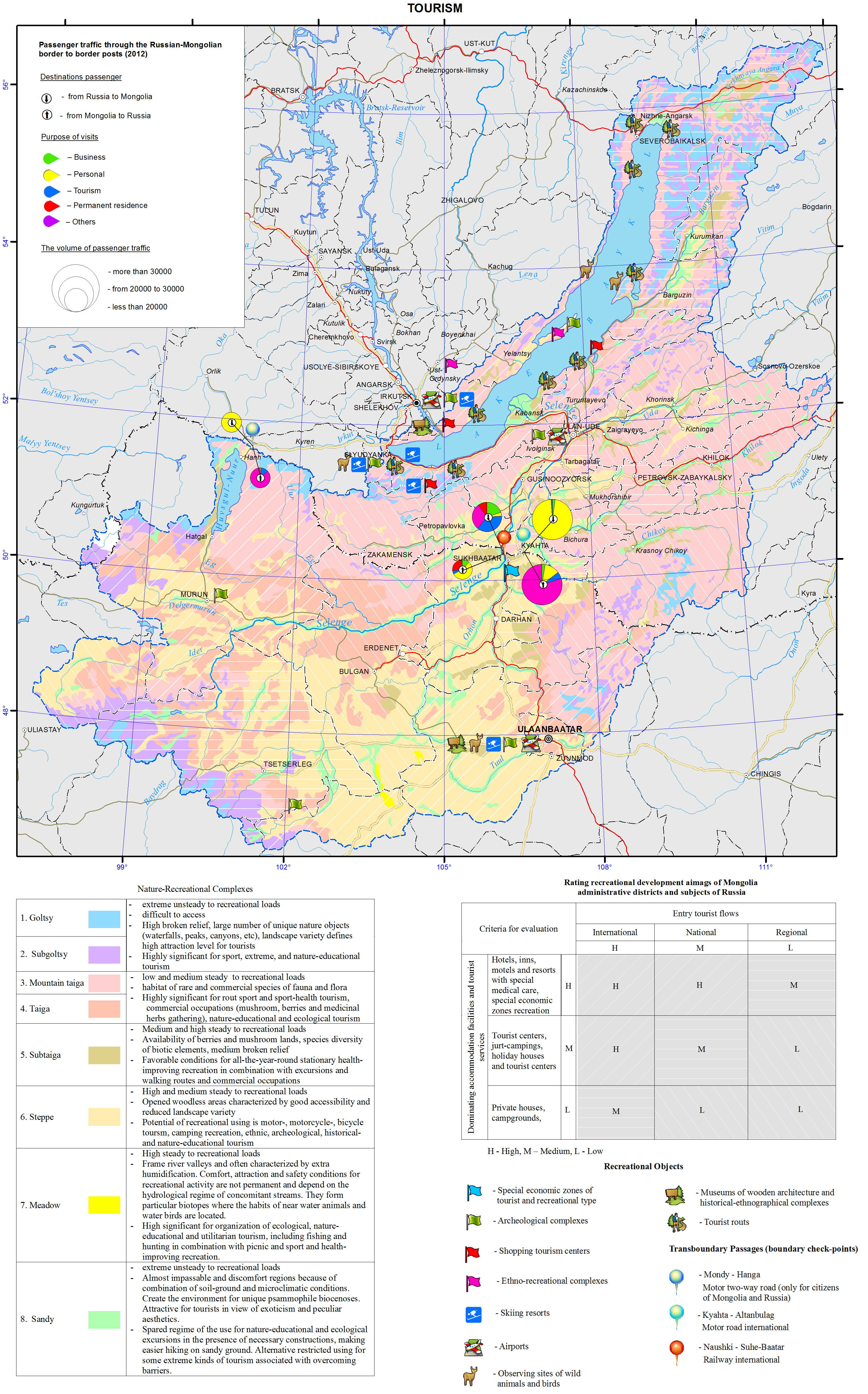
<p>The Baikal basin is a unique area that draws attention of tourists from all over the world. Its location in the heart of the Eurasian landmass has defined its high ethno-cultural and natural diversity. The history of development of the lands around Baikal is connected with the rise of two giant empires – Mongolian and Russian, as well as with the historical development of trade and transport routes.</p>
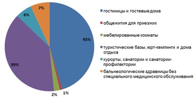
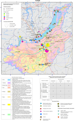
<p>The natural and resource nucleus of the recreational system of the Baikal basin is the oldest and deepest lake in the world itself. Infrastructural centers for tourism development are major cities of Ulaanbaatar, Irkutsk, and Ulan-Ude. They play the role of major international transport hubs and have administrative, educational, and cultural tourism resources, as well as a significant hospitality potential. In 2012, Ulaanbaatar had the largest hotel fund (over 170 hotels). There were about 80 hotels in Irkutsk and up to 20 in Ulan-Ude. In general, the transboundary area of the Baikal basin has over a thousand places for tourist accommodation of general and special purpose (Fig. 1).</p>
<p style="text-align: center; "><img class="image-inline" src="../../../resolveuid/e1da5a0a1de942da8b51036648fbd2bb/@@images/image/preview" /></p>
<ul>
<li>hotels and guest houses </li>
<li>hostel for visitors </li>
<li>hostels, yurt camping and rest houses </li>
<li>resorts, motels and sanatorium </li>
<li>balneologic resorts without special health care</li>
</ul>
<p style="text-align: justify; "><b>Figure 1. Recreational accommodation facilities in the transboundary Baikal basin [Business of the Angara region…, 2012; Activities of tourism firms..., 2011; Culture, tourism, and recreation…, 2012; Tourism in Sunny Buryatia, 2011; Soyol ..., 2013]</b></p>
<p>The number of accommodation facilities, as well as the level of offered services in conjunction with the configuration and nature of the tourist traffic help identify the most important areas for the tourism industry, assess the degree of tourism development, and get a general picture of a territorial structure of recreational activities. A matrix integrating the character of tourist traffic and a predominant type of accommodation was used as the basis for the expert assessment of tourism development of administrative units of Russia and Mongolia.</p>
<p>The main distinctive characteristics of the recreational system of the Baikal basin is its transboundary position. Therefore, the neighboring aimags of Mongolia and administrative districts of Irkutsk oblast and the Republic of Buryatia that are located along the state border and have cross-border corridors (ports of entry) are of a special significance.</p>
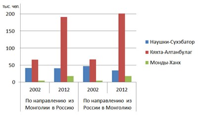
<p>The process of development of cross-border tourism in the neighboring territories of Russia and Mongolia is taking place under conditions, where both countries with a unique culture and nature are an integral part of the international recreational space, have a special interest for tourists from other countries, and make mutual contribution to the formation of the inbound tourist traffic. The Russian-Mongolian border, which crosses the basin, has three checkpoints that not only facilitate the exchange of foreign and domestic tour groups, but also serve as a prerequisite for the development of cross-border trade. Within 10 years, the total volume of passenger traffic through the existing checkpoints has more than doubled – from 229 thousand people in 2002 to 502.5 thousand people in 2012 (Fig. 2).</p>
<p style="text-align: center; "><img class="image-inline" src="../../../resolveuid/1c774d490c45475d9df1908773c75d9d/@@images/image/preview" /></p>
<p align="center"> </p>
<ul>
<li>Naushki-Sükhbaatar</li>
<li>Kyakhta-Altabulag</li>
<li>Mondy-Khankh</li>
</ul>
<p style="text-align: justify; "><b>Figure 2. Passenger traffic through the Russian-Mongolian border [Mongolian..., 2013; Mongolian ..., 2006]</b></p>
<p>Development of cross-border tourism requires joint decisions to promote a common tourism product on the state level. Such projects as “Baikal-Khovsgol”, which connects two great lakes of Asia, and “The Tea Road” have already become popular. The establishment of transboundary special protected areas have great prospects for the bilateral cooperation in the field of eco-tourism. They represent a particular organizational resource, which is important not only for the resolution of shared environmental problems, but also for the coordination of efforts aimed at implementing cross-border tourism projects.</p>
<p>Active cooperation between Russia and Mongolia in promoting tourism within the unique natural object – the Baikal basin not only opens the possibilities for increasing inbound foreign tourism in both countries, but also contributes to the expansion of similar relationships with other neighboring countries, such as China, Kazakhstan, and Japan.</p>
<p> </p>
<p align="center">References</p>
<p>Statistical Compendium. (2012). <i>Business of the Angara region: Tourism and hospitality</i>. Irkutsk: Irkutskstat. p 35-62.</p>
<p>Statistical Compendium. (2011). <i>Activities of tourism firms and collective accommodation facilities in the Republic of Buryatia in 2011</i>. Ulan-Ude: Buryatstat. p 7-12.</p>
<p>Statistical Compendium. (2012). <i>Culture, tourism, and recreation in the Angara region</i>. Irkutsk: Irkutskstat. p 45-52.</p>
<p>Statistical Compendium. (2011). <i>Tourism in Sunny Buryatia</i>. Ulan-Ude: Buryatstat. p 59.</p>
<p>National Statistical Office of Mongolia. (2013). <i>Soyol, sport, ayalal, zhuulchlalyn salbaryn lavlakh</i>. Ulaanbaatar. p 285.</p>
<p>National Statistical Office of Mongolia. (2012). <i>Mongolian statistical yearbook 2012</i>. Ulaanbaatar. p 297-299.</p>
<p>National Statistical Office of Mongolia. (2007). <i>Mongolian statistical yearbook 2006</i>. Ulaanbaatar. p 265-269.</p>]]></content:encoded>
    <dc:publisher>No publisher</dc:publisher>
    <dc:creator>Alexander Ayurzhanaev</dc:creator>
    <dc:rights></dc:rights>
    <dc:date>2014-10-07T00:56:13Z</dc:date>
    <dc:type>Page</dc:type>
  </item>


  <item rdf:about="http://bic.iwlearn.org/en/atlas/atlas/28-maximum-runoff-during-the-flood-map/maximum-runoff-during-the-flood-map">
    <title>Maximum runoff during the flood map</title>
    <link>http://bic.iwlearn.org/en/atlas/atlas/28-maximum-runoff-during-the-flood-map/maximum-runoff-during-the-flood-map</link>
    <description></description>
    <content:encoded xmlns:content="http://purl.org/rss/1.0/modules/content/"><![CDATA[<p><img class="image-inline" src="../../../resolveuid/7e21331f5819408badfa79e4240cb100/@@images/image/preview" /></p>
<p><a href="http://bic.iwlearn.org/en/atlas/photos/copy_of__28_Maximumrunoffduringtheflood.png" class="internal-link">Open full size</a></p>
<p align="center"><strong>Flow</strong></p>
<p>The map “Mean annual flow” reflects the formation patterns of the water regime of the territory, which are determined by the properties of landscapes to transform atmospheric moisture into the runoff.</p>
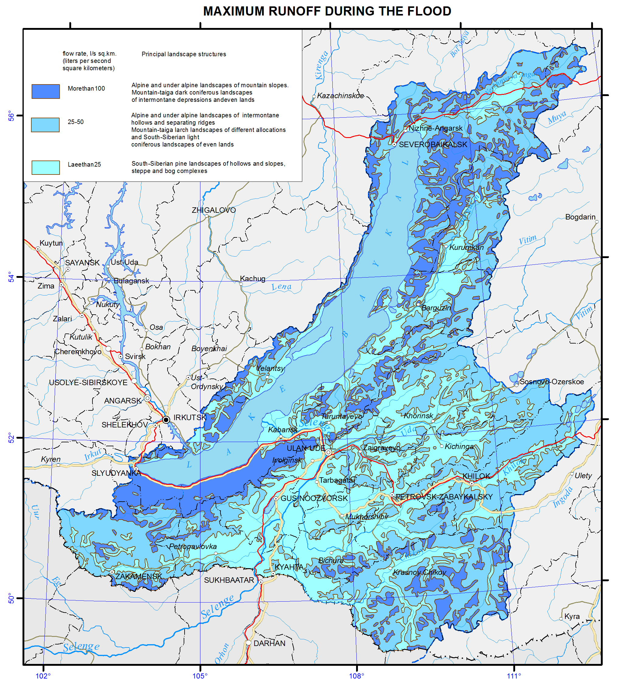
<p>For a water body basin, the surface runoff is the total amount of water loss from the watershed landscapes. The runoff rate from landscape complexes is determined by solving the inverse problem, i.e. identification of the connection of flow rate at the main stream station of a catchment with the runoff from landscapes, occupying its area, and is calculated based on the equation Q<sub>j</sub> = ∑q<sub>i</sub> f<sub>ij</sub><i>,</i><i> </i>where <i>j</i> is the index of the river basin, Q<sub>j</sub> is its runoff, L/s; q<sub>i</sub> is a modification of flow from the i-th landscape complex, L/s km<sup>2</sup>; f<sub>ij</sub> is an area of the j-th basin occupied by the i-th landscape, km<sup>2</sup>. Long-term average runoff data for small and medium-sized rivers of theLake Baikal basin were used in calculations for the map construction [Long-term…, 1986, http://www.r-arcticnet.sr.unh.edu]. Characteristics of landscape components were obtained on the basis of the materials on landscape of the Baikal region [Landscapes…, 1977, Natural..., 2009, Landscapes…, 1990, Lysanova et al., 2009]. In accordance with the regional dimension, generalization degree is chosen at the geom level, and their average annual flow moduli are determined. The territory on the map is divided into regions according to five gradations of the module - from less than 1 to more than 10 L/s km<sup>2</sup>.</p>
<p>The catchment area of the lake covers a variety of landscape zones and altitudinal belts, which makes a great contrast between the runoff rates. The highest annual flow moduli are formed within the goletz and mountain-taiga landscapes. Steppe and forest-steppe areas are distinguished by the minimum runoff rates, and in the desert regions of Mongolia (the Selenga river basin) flow formation almost does not take place.</p>
<p>The maps of minimum and maximum flow were compiled based on the typological landscape classification represented on the map [Landscapes…, 1977]. In the course of investigation, landscapes of different types were generalized by identifying the most hydrologically informative properties (morphological characteristics, vegetation structure, altitudinal zonation, etc.). As a result, more than 200 landscapes were combined into sixteen types of natural complexes, and runoff rates were determined for them. The moduli of maximum snow runoff and minimum summer runoff were calculated as described above.</p>
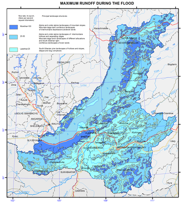
<p>Areas with the highest runoff of floods are confined to the mountain ranges and systems with goletz open woodlands and mountain-taiga landscapes. The main areas, distinguished by formation of frequent and high floods are the Baikalsky Range on the north-eastern end of the lake; Barguzinsky Range, located in the south-eastern part of the catchment, and the Khamar-Daban, covering the south-western shore of Lake Baikal. The values of the maximum flow modification are shown in three gradations on the map, namely: less than 25, 25-70, and more than 100 L/s km<sup>2</sup>.</p>
<p>Features of formation of the minimum summer runoff in the Baikal basin are associated with the regime of atmospheric moisture, as well as with the effects of altitude and exposition. The calculations and analysis of the minimum summer runoff have shown a relatively high water yield in the low-flow period from high-mountain taiga landscapes and extremely low river flow formation in the central areas of the Selenga river catchment and in Priolkhonie, which are covered with light coniferous landscapes and steppe complexes on slopes and plains. The map shows the value of the minimum flow in three gradations, namely: less than 1.5, 3.0-5.0, and more than 5.0 L/s km<sup>2</sup>.</p>
<p>Landscape-hydrological mapping based on the quantitative characteristics of water yield of landscape complexes objectively reflects the hydrological organization of the territory.</p>
<p><b> </b></p>
<p align="center">References</p>
<p>Kuznetsova T.I. (2009). Map "Natural landscapes of the Baikal region and their use: purpose, structure, and content”.  T.I. Kuznetsova, A.R. Batuev, and A.V. Bardash. <i>Geodeziya i kartografiya,</i> , no 9, pp. 18-28.</p>
<p>Landscapes of southern East Siberia [Maps]: [physical map] (1977) / compiled and prep. for printing by factory no. 4 GUGK in 1976, authors: V.S. Mikheev and V.A. Ryashin. 1: 1 500 000, Moscow: GUGK, 1 map (4 sheets): col.</p>
<p>Landscapes [Maps] [physical map] / The National Atlas of the Mongolian People's Republic. / comp .and prep to print by GUGK in 1989, authors: B.M. Ishmuratov, K.N. Misevich, I.L. Savelyeva, et al.</p>
<p>Lysanova, G.I., Semenov, Yu.M., Shekhovtsov, A.I., and Sorokovoy, A.A. (2013). Geosystems of the Republic of Tuva. <i>Geografiya i prirodnye resursy</i>, no. 3, pp. 181-185.</p>
<p>Long-term data on the regime and surface water resources. The Baikal basin. (1986). Vol. 1, no. 14, Leningrad: Gidrometeoizdat, 361 p.</p>
<p><b><i>A Regional, Electronic, Hydrographic Data Network For the Arctic Region.</i></b> <b>URL: </b><a href="http://www.r-arcticnet.sr.unh.edu/"><b>http://www.r-arcticnet.sr.unh.edu</b></a></p>]]></content:encoded>
    <dc:publisher>No publisher</dc:publisher>
    <dc:creator>Alexander Ayurzhanaev</dc:creator>
    <dc:rights></dc:rights>
    <dc:date>2014-10-06T04:20:00Z</dc:date>
    <dc:type>Page</dc:type>
  </item>


  <item rdf:about="http://bic.iwlearn.org/en/friends/mongolian/ngo-network-report">
    <title>NGO network report</title>
    <link>http://bic.iwlearn.org/en/friends/mongolian/ngo-network-report</link>
    <description></description>
    
    <dc:publisher>No publisher</dc:publisher>
    <dc:creator>silbi_747@yahoo.com</dc:creator>
    <dc:rights></dc:rights>
    <dc:date>2014-09-02T08:27:28Z</dc:date>
    <dc:type>File</dc:type>
  </item>


  <item rdf:about="http://bic.iwlearn.org/en/documents/documents/papers/Geoinformational%20of%20Monitoring%20of%20Natural%20Landscape%20Baikal%20Basin%20-english.pdf">
    <title>Geoinformational support of monitoring of natural landscape transformation in the basin of lake Baikal on the basis of retrospective cartographic materials (english).</title>
    <link>http://bic.iwlearn.org/en/documents/documents/papers/Geoinformational%20of%20Monitoring%20of%20Natural%20Landscape%20Baikal%20Basin%20-english.pdf</link>
    <description></description>
    
    <dc:publisher>No publisher</dc:publisher>
    <dc:creator>Alexander Ayurzhanaev</dc:creator>
    <dc:rights></dc:rights>
    <dc:date>2014-04-15T00:50:12Z</dc:date>
    <dc:type>File</dc:type>
  </item>


  <item rdf:about="http://bic.iwlearn.org/en/documents/documents/papers/Spatio-temporal%20dynamics%20of%20vegetation%20cover%20of%20arid%20and%20semiarid%20climatic%20zones%20in%20central%20Mongolia%20on%20the%20basis%20of%20time%20series%20NDVI%20and%20field%20studies%20-rus.pdf">
    <title>Spatio-temporal dynamics of vegetation cover of arid and semiarid climatic zones in central Mongolia on the basis of time series NDVI and field studies (rus).</title>
    <link>http://bic.iwlearn.org/en/documents/documents/papers/Spatio-temporal%20dynamics%20of%20vegetation%20cover%20of%20arid%20and%20semiarid%20climatic%20zones%20in%20central%20Mongolia%20on%20the%20basis%20of%20time%20series%20NDVI%20and%20field%20studies%20-rus.pdf</link>
    <description></description>
    
    <dc:publisher>No publisher</dc:publisher>
    <dc:creator>Alexander Ayurzhanaev</dc:creator>
    <dc:rights></dc:rights>
    <dc:date>2014-04-11T06:20:00Z</dc:date>
    <dc:type>File</dc:type>
  </item>


  <item rdf:about="http://bic.iwlearn.org/en/documents/documents/papers/Spatial%20and%20temporal%20dynamics%20of%20the%20Baikal%20coastal%20line%20caused%20by%20control%20of%20the%20lake%20level%20regime%20-english.pdf">
    <title>Spatial and temporal dynamics of the Baikal coastal line caused by control of the lake level regime (english).</title>
    <link>http://bic.iwlearn.org/en/documents/documents/papers/Spatial%20and%20temporal%20dynamics%20of%20the%20Baikal%20coastal%20line%20caused%20by%20control%20of%20the%20lake%20level%20regime%20-english.pdf</link>
    <description></description>
    
    <dc:publisher>No publisher</dc:publisher>
    <dc:creator>Alexander Ayurzhanaev</dc:creator>
    <dc:rights></dc:rights>
    <dc:date>2014-04-11T06:20:00Z</dc:date>
    <dc:type>File</dc:type>
  </item>


  <item rdf:about="http://bic.iwlearn.org/en/documents/documents/papers/Identifying%20desertified%20territories%20based%20on%20comprehensive%20analysis%20of%20multispectral%20-LANDSAT-%20and%20radar%20-SRTM-%20satellite%20data%20-rus.pdf">
    <title>Identifying desertified territories based on comprehensive analysis of multispectral (LANDSAT) and radar (SRTM) satellite data (rus).</title>
    <link>http://bic.iwlearn.org/en/documents/documents/papers/Identifying%20desertified%20territories%20based%20on%20comprehensive%20analysis%20of%20multispectral%20-LANDSAT-%20and%20radar%20-SRTM-%20satellite%20data%20-rus.pdf</link>
    <description></description>
    
    <dc:publisher>No publisher</dc:publisher>
    <dc:creator>Alexander Ayurzhanaev</dc:creator>
    <dc:rights></dc:rights>
    <dc:date>2014-04-11T06:18:18Z</dc:date>
    <dc:type>File</dc:type>
  </item>


  <item rdf:about="http://bic.iwlearn.org/en/documents/documents/proceedings/2013/TOM%202_Environment%20and%20sustainable%20development%20in%20Mongolian%20plateau%20and%20surrounding%20regions%20-rus.pdf">
    <title>Тom 2_Environment and sustainable development in Mongolian plateau and surrounding regions (rus).</title>
    <link>http://bic.iwlearn.org/en/documents/documents/proceedings/2013/TOM%202_Environment%20and%20sustainable%20development%20in%20Mongolian%20plateau%20and%20surrounding%20regions%20-rus.pdf</link>
    <description></description>
    
    <dc:publisher>No publisher</dc:publisher>
    <dc:creator>Alexander Ayurzhanaev</dc:creator>
    <dc:rights></dc:rights>
    <dc:date>2014-04-10T03:05:00Z</dc:date>
    <dc:type>File</dc:type>
  </item>


  <item rdf:about="http://bic.iwlearn.org/en/documents/documents/proceedings/2013/TOM%201_Environment%20and%20sustainable%20development%20in%20Mongolian%20plateau%20and%20surrounding%20regions%20-rus.pdf">
    <title>Тom 1_Environment and sustainable development in Mongolian plateau and surrounding regions (rus).</title>
    <link>http://bic.iwlearn.org/en/documents/documents/proceedings/2013/TOM%201_Environment%20and%20sustainable%20development%20in%20Mongolian%20plateau%20and%20surrounding%20regions%20-rus.pdf</link>
    <description></description>
    
    <dc:publisher>No publisher</dc:publisher>
    <dc:creator>Alexander Ayurzhanaev</dc:creator>
    <dc:rights></dc:rights>
    <dc:date>2014-04-10T03:05:00Z</dc:date>
    <dc:type>File</dc:type>
  </item>


  <item rdf:about="http://bic.iwlearn.org/en/documents/documents/monographs/Anthropogenic%20transformation%20of%20natural%20systems%20and%20their%20socio-economic%20impacts%20in%20the%20Selenga%20river%20basin%20-rus.pdf">
    <title>Anthropogenic transformation of natural systems and their socio-economic impacts in the Selenga river basin (rus).</title>
    <link>http://bic.iwlearn.org/en/documents/documents/monographs/Anthropogenic%20transformation%20of%20natural%20systems%20and%20their%20socio-economic%20impacts%20in%20the%20Selenga%20river%20basin%20-rus.pdf</link>
    <description></description>
    
    <dc:publisher>No publisher</dc:publisher>
    <dc:creator>Alexander Ayurzhanaev</dc:creator>
    <dc:rights></dc:rights>
    <dc:date>2014-04-10T02:50:00Z</dc:date>
    <dc:type>File</dc:type>
  </item>


  <item rdf:about="http://bic.iwlearn.org/en/documents/documents/papers/Fish%20nutrition%20in%20some%20small%20reservoirs%20of%20the%20Ivan-Arakhley%20system%20and%20their%20potential%20for%20piscicultural%20operations%20-rus.pdf">
    <title>Fish nutrition in some small reservoirs of the Ivan-Arakhley system and their potential for piscicultural operations (rus).</title>
    <link>http://bic.iwlearn.org/en/documents/documents/papers/Fish%20nutrition%20in%20some%20small%20reservoirs%20of%20the%20Ivan-Arakhley%20system%20and%20their%20potential%20for%20piscicultural%20operations%20-rus.pdf</link>
    <description></description>
    
    <dc:publisher>No publisher</dc:publisher>
    <dc:creator>Alexander Ayurzhanaev</dc:creator>
    <dc:rights></dc:rights>
    <dc:date>2014-03-28T13:15:00Z</dc:date>
    <dc:type>File</dc:type>
  </item>


  <item rdf:about="http://bic.iwlearn.org/en/documents/documents/papers/Estimation%20of%20forest%20biomass%20using%20satellite%20%20radar%20data%20-rus.pdf">
    <title>Estimation of forest biomass using satellite  radar data (rus).</title>
    <link>http://bic.iwlearn.org/en/documents/documents/papers/Estimation%20of%20forest%20biomass%20using%20satellite%20%20radar%20data%20-rus.pdf</link>
    <description></description>
    
    <dc:publisher>No publisher</dc:publisher>
    <dc:creator>Alexander Ayurzhanaev</dc:creator>
    <dc:rights></dc:rights>
    <dc:date>2014-03-28T13:15:00Z</dc:date>
    <dc:type>File</dc:type>
  </item>


  <item rdf:about="http://bic.iwlearn.org/en/documents/documents/papers/Geoinformational%20of%20Monitoring%20of%20Natural%20Landscape%20Baikal%20Basin%20-rus.pdf">
    <title>Geoinformational support of monitoring of natural landscape transformation in the basin of lake Baikal on the basis of retrospective cartographic materials (rus).</title>
    <link>http://bic.iwlearn.org/en/documents/documents/papers/Geoinformational%20of%20Monitoring%20of%20Natural%20Landscape%20Baikal%20Basin%20-rus.pdf</link>
    <description></description>
    
    <dc:publisher>No publisher</dc:publisher>
    <dc:creator>Alexander Ayurzhanaev</dc:creator>
    <dc:rights></dc:rights>
    <dc:date>2014-03-28T09:25:00Z</dc:date>
    <dc:type>File</dc:type>
  </item>


  <item rdf:about="http://bic.iwlearn.org/en/documents/documents/papers/Identification%20of%20%20the%20sources%20of%20water%20%20pollution%20on%20the%20basis%20the%20GIS-technologies%20-rus.pdf">
    <title>Identification of  the sources of water  pollution on the basis the GIS-technologies (rus).</title>
    <link>http://bic.iwlearn.org/en/documents/documents/papers/Identification%20of%20%20the%20sources%20of%20water%20%20pollution%20on%20the%20basis%20the%20GIS-technologies%20-rus.pdf</link>
    <description></description>
    
    <dc:publisher>No publisher</dc:publisher>
    <dc:creator>Alexander Ayurzhanaev</dc:creator>
    <dc:rights></dc:rights>
    <dc:date>2014-03-28T09:25:00Z</dc:date>
    <dc:type>File</dc:type>
  </item>


  <item rdf:about="http://bic.iwlearn.org/en/documents/documents/papers/Territorial%20estimation%20of%20flooding%20risk%20in%20the%20Baikal%20region%20in%20the%20conditions%20of%20ecological%20restrictions%20-rus.pdf">
    <title>Territorial estimation of flooding risk in the Baikal region in the conditions of ecological restrictions (rus).</title>
    <link>http://bic.iwlearn.org/en/documents/documents/papers/Territorial%20estimation%20of%20flooding%20risk%20in%20the%20Baikal%20region%20in%20the%20conditions%20of%20ecological%20restrictions%20-rus.pdf</link>
    <description></description>
    
    <dc:publisher>No publisher</dc:publisher>
    <dc:creator>Alexander Ayurzhanaev</dc:creator>
    <dc:rights></dc:rights>
    <dc:date>2014-03-28T09:25:00Z</dc:date>
    <dc:type>File</dc:type>
  </item>


</rdf:RDF>