<?xml version="1.0" encoding="utf-8" ?>
<rdf:RDF xmlns:rdf="http://www.w3.org/1999/02/22-rdf-syntax-ns#" xmlns:dc="http://purl.org/dc/elements/1.1/" xmlns:syn="http://purl.org/rss/1.0/modules/syndication/" xmlns="http://purl.org/rss/1.0/">


<channel rdf:about="http://bic.iwlearn.org/search_rss">
  <title>Байкальский информационный центр</title>
  <link>http://bic.iwlearn.org</link>

  <description>
    
            These are the search results for the query, showing results 31 to 45.
        
  </description>


  <image rdf:resource="http://bic.iwlearn.org/logo.png"/>

  <items>
    <rdf:Seq>
      
        <rdf:li rdf:resource="http://bic.iwlearn.org/en/documents/state-of-the-environment-report-the-lake-baikal-basin-1/general-conditions-of-the-baikal-lake-basin/1-5-water-level-of-lake-baikal"/>
      
      
        <rdf:li rdf:resource="http://bic.iwlearn.org/en/documents/state-of-the-environment-report-the-lake-baikal-basin-1/general-conditions-of-the-baikal-lake-basin/1-4-climatic-conditions"/>
      
      
        <rdf:li rdf:resource="http://bic.iwlearn.org/en/documents/state-of-the-environment-report-the-lake-baikal-basin-1/general-conditions-of-the-baikal-lake-basin/1-3-specially-protected-natural-territories"/>
      
      
        <rdf:li rdf:resource="http://bic.iwlearn.org/en/documents/state-of-the-environment-report-the-lake-baikal-basin-1/general-conditions-of-the-baikal-lake-basin/1-2-territorial-administrative-division"/>
      
      
        <rdf:li rdf:resource="http://bic.iwlearn.org/en/documents/state-of-the-environment-report-the-lake-baikal-basin-1/general-conditions-of-the-baikal-lake-basin/physical-and-geographical-position"/>
      
      
        <rdf:li rdf:resource="http://bic.iwlearn.org/en/documents-1/state-report-state-and-preservation-of-environment-of-buryatia-2012-rus"/>
      
      
        <rdf:li rdf:resource="http://bic.iwlearn.org/en/documents-1/state-report-on-the-state-of-the-environment-in-russian-federation-and-its-protection-2012-rus"/>
      
      
        <rdf:li rdf:resource="http://bic.iwlearn.org/en/documents-1/state-report-on-the-state-of-the-environment-in-irkutsk-region-and-its-protection-2012-rus"/>
      
      
        <rdf:li rdf:resource="http://bic.iwlearn.org/en/documents-1/state-report-on-the-state-of-lake-baikal-and-the-measures-for-its-protection-2012-rus"/>
      
      
        <rdf:li rdf:resource="http://bic.iwlearn.org/en/documents-1/report-on-the-environmental-situation-in-the-zabaikalsky-krai-2012-rus"/>
      
      
        <rdf:li rdf:resource="http://bic.iwlearn.org/en/documents-1/state-report-on-the-state-of-the-environment-in-russian-federation-and-its-protection-2011-rus"/>
      
      
        <rdf:li rdf:resource="http://bic.iwlearn.org/en/documents-1/report-on-the-environmental-situation-in-the-zabaikalsky-krai-2011-rus"/>
      
      
        <rdf:li rdf:resource="http://bic.iwlearn.org/en/documents-1/state-report-on-the-state-of-the-environment-in-irkutsk-region-and-its-protection-2011-rus"/>
      
      
        <rdf:li rdf:resource="http://bic.iwlearn.org/en/documents-1/state-report-state-and-preservation-of-environment-of-buryatia-2011-rus"/>
      
      
        <rdf:li rdf:resource="http://bic.iwlearn.org/en/documents/documents/state-reports/2011/state-of-the-environment-report-mongolia-2008-2010-english-1"/>
      
    </rdf:Seq>
  </items>

</channel>


  <item rdf:about="http://bic.iwlearn.org/en/documents/state-of-the-environment-report-the-lake-baikal-basin-1/general-conditions-of-the-baikal-lake-basin/1-5-water-level-of-lake-baikal">
    <title>1.5 Water Level of Lake Baikal</title>
    <link>http://bic.iwlearn.org/en/documents/state-of-the-environment-report-the-lake-baikal-basin-1/general-conditions-of-the-baikal-lake-basin/1-5-water-level-of-lake-baikal</link>
    <description></description>
    <content:encoded xmlns:content="http://purl.org/rss/1.0/modules/content/"><![CDATA[<p align="center"><b>1.5 Water Level of Lake Baikal</b></p>
<p><b> </b></p>
<p style="text-align: justify; ">In the average long-term water budget of Lake Baikal, the inflow components are:</p>
<p style="text-align: justify; ">- surface water inflow (57.77 km<sup>3</sup>/year – 82.4 %);</p>
<p style="text-align: justify; ">- precipitation (9.26 km<sup>3</sup>/year – 13.2%);</p>
<p style="text-align: justify; ">- ground water inflow (3.12 km<sup>3</sup>/year – 4.4 %) [6].</p>
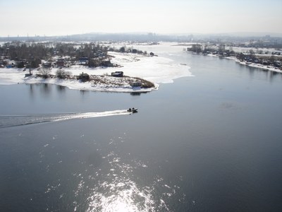
<p style="text-align: justify; ">The outflow components are the following: surface water outflow – the Angara River (60.89 km<sup>3</sup> – 86.8 %) (<em>pic.</em> 1.5.1); and evaporation (9.26 км<sup>3</sup> – 13.2 %).<span> </span></p>
<p align="center"><img class="image-inline" src="../../../resolveuid/cf9ca64eb18743b2931209d358d48ce2/@@images/image/preview" /></p>
<p align="center">Pic. 1.5.1 The Angara River in Irkutsk city</p>
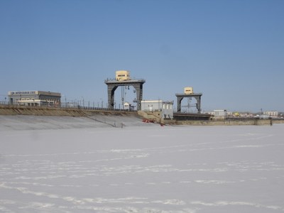
<p style="text-align: justify; ">The water level in the lake depends on the operating modes of Irkutsk Hydroelectric Power Station (HEPS), Bratsk HEPS and Ust-Ilimsk HEPS, all working interdependently.  Boguchanskaya HEPS has been in commercial operation since December 1, 2012, and filling of its water reservoir began in summer 2012 and finished in 2014. After construction of the dam of Irkutsk HEPS (44 m high and 2.5 km long) (<em>pic. </em>1.5.2) 70 km downstream of the Angara River source and filling of Irkutsk Reservoir (1956-1958), the backup water reached Lake Baikal in 1959 and caused its long-term water level to rise by 1.3 m (456.8 m) in 1964.</p>
<p align="center"><img class="image-inline" src="../../../resolveuid/e6b9e35ac6f74dce9a86f6529a4d3599/@@images/image/preview" /></p>
<p align="center">Pic. 1.5.2  The dam of Irkutsk HEPS<span> </span></p>
<p style="text-align: justify; ">Further, the average long-term regulated water level of the lake (equal to the water level of Irkutsk Reservoir) was maintained at 1 m above the average water level prior to the construction of HEPS. This allowed using a part of the lake volume for controlling outflow by artificially regulating the water level on a seasonal and long-term basis. With its outflow backed up, the annual changes in Lake Baikal water level remained generally close to its natural values. The artificial regulation of the lake level resulted in increased amplitude of level fluctuations (from 80 to 113 cm) and a shift towards delayed in time maximum discharge of water and filling of reservoir. The annual changes in the level of Lake Baikal are characterized by a gradual rise until the levels become close to the normal dammed levels (in May-September), stabilization of maximum levels in October and a decrease during November to April.</p>
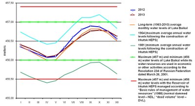
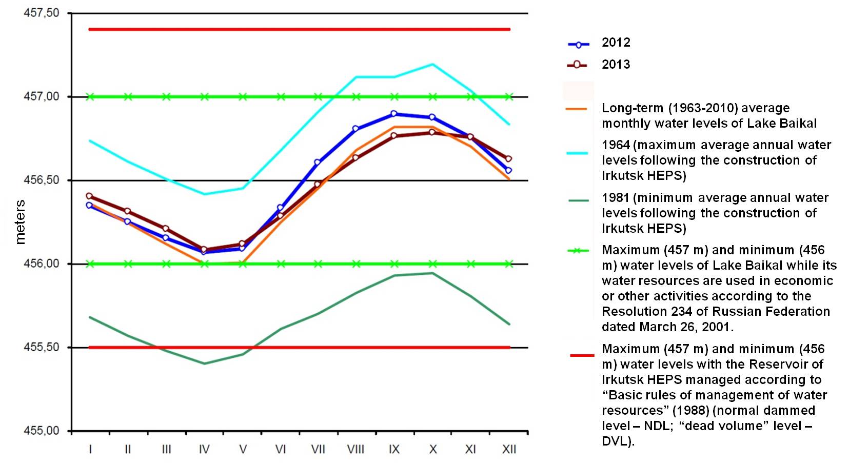
<p style="text-align: justify; ">As of January 1, 2013, the average water level of Lake Baikal was 456.46 m, which was 0.07 higher than in the previous year and 0.03 m higher than the long-term average (456.43 m) (<em>pic. </em>1.5.3) [6]. In 2013, during the period when the lake was filled up, the water levels were within the range of long-term values, as a result of smooth regulation of discharge without abrupt fluctuations. The amplitude of level fluctuations was 0.76 m in 2013.</p>
<p align="center"><b> </b><b> </b></p>
<p align="center"><img class="image-inline" src="../../../resolveuid/2db85bc21bd84ffd9f931dc0df8c2aa8/@@images/image/preview" /></p>
<p align="center"><a href="http://bic.iwlearn.org/en/documents/photos/1.5.3e.jpg" class="internal-link">Open full size</a></p>
<p style="text-align: center; ">Pic<em>.</em> 1.5.3 Average monthly water levels of Lake Baikal in 2012 and 2013 compared with the years of the highest (1964) and lowest (1981) levels and long-term values.</p>]]></content:encoded>
    <dc:publisher>No publisher</dc:publisher>
    <dc:creator>Zorigma</dc:creator>
    <dc:rights></dc:rights>
    <dc:date>2015-04-23T06:34:15Z</dc:date>
    <dc:type>Page</dc:type>
  </item>


  <item rdf:about="http://bic.iwlearn.org/en/documents/state-of-the-environment-report-the-lake-baikal-basin-1/general-conditions-of-the-baikal-lake-basin/1-4-climatic-conditions">
    <title>1.4 Climatic conditions</title>
    <link>http://bic.iwlearn.org/en/documents/state-of-the-environment-report-the-lake-baikal-basin-1/general-conditions-of-the-baikal-lake-basin/1-4-climatic-conditions</link>
    <description></description>
    <content:encoded xmlns:content="http://purl.org/rss/1.0/modules/content/"><![CDATA[<p align="center"><strong>1.4 Climatic conditions</strong></p>
<p style="text-align: justify; ">The location of Lake Baikal basin in the central part of the vast Eurasian continent and its mountain-depression relief have equally determined the particular and, in a sense, unique climatic conditions. The specific feature of the climate is its abrupt and frequent spatial variability due to the presence of mountain ranges of different heights and orientation, intermountain depressions and valleys, orographic forms, which produces a strong impact on the local circulation of air masses, changing abruptly the main orographic indicators and producing uneven climate.</p>
<p style="text-align: justify; ">The territory is characterized with extremely continental climate with considerable annual and daily fluctuations of air temperature and uneven distribution of precipitation by seasons [3]. The exception is a narrow strip along the lake, where the signs of maritime climate with cooler summer and milder winters as compared to the surrounding territories. Extremely continental climate is characterized with cold winters and hot summers. One of its specialties is that, during the cold period, the region faces a powerful northeastern extension of the Siberian anticyclone, which comes in September-October and disappears in April-May.</p>
<p style="text-align: justify; ">Low winter temperatures are easily tolerated due to dry air. Severe windless winter is followed by late windy and dry spring with night frost, lasting till the first decade of June.  High summer temperatures can be felt only at noon hours, while the morning and evening hours are enjoyable for their cool temperature. Summer is short, its first half is droughty and second half (July-August) – rainy. Autumn is rather warm and lasts until Baikal is covered with snow.</p>
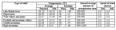
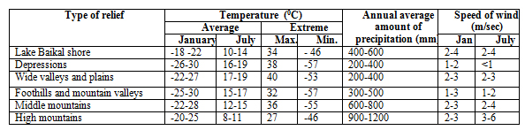
<p style="text-align: justify; ">Climatic conditions in Lake Baikal basin are determined by the character of atmospheric circulation and radiation regime as well as by the structure of the surface and the impact of water masses on the shore regions (table 1.4.1).</p>
<p style="text-align: center; ">Table 1.4.1 Distribution of temperatures, precipitation, speed of winds in correlation with relief</p>
<p style="text-align: center; "><img class="image-inline" src="../../../resolveuid/3804e0c733b941a98e25e94e252fafb1/@@images/image/preview" /></p>
<p style="text-align: center; "><a href="http://bic.iwlearn.org/en/documents/photos/copy3_of_1.jpg" class="internal-link">Open full size</a></p>
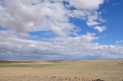
<p style="text-align: justify; "><strong>Atmospheric pressure. </strong>In winter, the major atmospheric phenomenon is the Asian (Siberian) anticyclone with the center in the north-west of Mongolia, reaching its maximum power in January [3]. In spring, the power of the anticyclone subsides, which makes dominant the factors of zonal circulation, conditioning the west-east transfer. Apart from the transfer of atmospheric entities from west to east, spring is marked with the arrival of cyclones from Central Asia. In summer, circulatory processes are characterized with the weakening of the west-east transfer. On the land surface, the baric field of reduced pressure with weak winds prevails (pic. 1.4.1).</p>
<p align="center"><img class="image-inline" src="../../../resolveuid/fa0d8f0af0ba4204a9f28482e4104e42/@@images/image/preview" /></p>
<p align="center">Pic. 1.4.1 The clouds over the Mongolian steppe</p>
<p style="text-align: justify; ">When the blocking warm anticyclone is located over the central regions of Yakutia, southern cyclones come from Mongolia to the area of Lake Baikal, moving subsequently to the west or north-west.  Central forms of summer circulation occur under the intensive development of pressure ridges and troughs. Circulatory conditions in autumn are characterized with the formation of the general west-east transfer, interrupted by meridional intrusions of cold masses from the north. Siberian anticyclone is at the stage of inception. In comparison with the spring season, autumn west-east movements of baric systems occur slower. The final transition to winter conditions of circulation is due in mid-November, when the Siberian anticyclone becomes rather stable.</p>
<p style="text-align: justify; "><strong>Air temperature. </strong>Within the territory of Baikal depression, climatic conditions of the surrounding areas are heavily influenced by Lake Baikal [3]. While climate of the inland territories of Irkutsk region, Republic of Buryatia, Zabaikalsky Krai and Mongolia can be considered as extremely continental, local climatic conditions of Baikal shore area are close to maritime climate. Temperature of winter months on the shore of south Baikal is on the average 5<sup>о</sup><sup> </sup>С higher, and in summer months is as much lower than in the central areas. In summer time, temperature inversions are observed above the lake surface, impeding the ascending movements. The totality of radiological and circulatory factors and local conditions determine the peculiarities of the thermal regime.</p>
<p style="text-align: justify; ">In winter, due to the prevalence of anticyclone weather, air temperature depends mainly on the radiological conditions and air is cooled considerably above the surface. In summer, radiological factors play the dominant role in the formation of the temperature regime as well. The average long-term air temperature on most of the territory is below zero. The stations, located on the shore of Baikal, enjoy higher temperatures than the inland stations located on the same latitudes. The coldest month is January, the hottest month is July.</p>
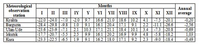
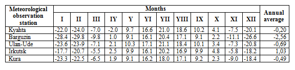
<p style="text-align: justify; ">Spatial differentiation of temperature indicators within the basin is essential. Average daily temperature in the uplands does not reach 10 <sup>0</sup>С, and its total value varies from 2400 <sup>0</sup>С in the south of the basin to 500 <sup>0</sup>С on the north-eastern shore of the lake (табл. 1.3.2).</p>
<p style="text-align: center; ">Table 1.4.2 Monthly averages of air temperature, <sup>°</sup>С (by meteorological station)</p>
<p style="text-align: center; "><img class="image-inline" src="../../../resolveuid/5ddc51070e1a4acf834b8654ab88e59f/@@images/image/preview" /></p>
<p style="text-align: center; "><a href="http://bic.iwlearn.org/en/documents/photos/copy5_of_2.jpg" class="internal-link">Open full size</a></p>
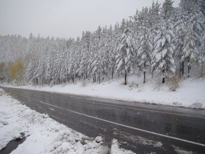
<p style="text-align: justify; "><strong>Atmospheric precipitation. </strong>The patterns of precipitation formation and distribution on the research territory are considerably influenced by the peculiarities of mountainous relief [3]. The altitude of the area and, more specifically, the location of mountains in relation to the moisture-carrying air currents make the distribution of precipitation highly uneven. The same altitudes of mountain ridges are characterized with different amount of precipitation (pic 1.4.2).</p>
<p align="center"><img class="image-inline" src="../../../resolveuid/a8804e4b9a064334a1862109539f4018/@@images/image/preview" /></p>
<p align="center">Pic 1.4.2  Snow on the mountain pass Mandrik</p>
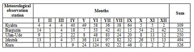
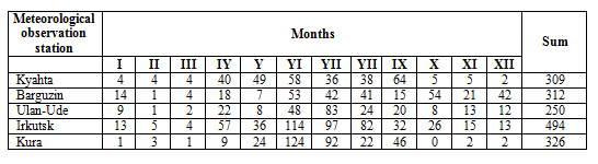
<p style="text-align: justify; ">The maximum amount of precipitation is typical of the north-western and western slopes of the ridges, primary towards the prevalent air currents and bounding Lake Baikal – up to 1400 mm on the wind-faced slopes of the secondary ridges and in the interior regions of the uplands – 400-700 mm. In the grassland area of the western shore of Lake Baikal and its islands the amount of precipitation is 200-250 mm, in the intermountain depressions and valleys of the Uda and Selenga rivers – up to 300 mm (table 1.3.3).</p>
<p style="text-align: center; ">Table 1.4.3 Monthly and Annual precipitation, mm (by meteorological station)</p>
<p style="text-align: center; "><img class="image-inline" src="../../../resolveuid/d22e239c9a5c48b4a982aa913dfbcc57/@@images/image/preview" /></p>
<p style="text-align: center; "><a href="http://bic.iwlearn.org/en/documents/photos/copy_of_3.jpg" class="internal-link">Open full size</a></p>
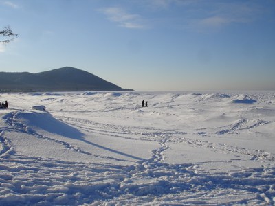
<p style="text-align: justify; "><strong>Snow cover. </strong>Snow cover is formed unevenly [3]. Its height decreases from the north-east of Lena-Angara plateau (50-80 cm) to 5-10 cm on the vast plains of Transbaikalia and Mongolia. This  is conditioned by the interaction of powerful northeastern air currents with the weakened Pacific currents as well as the rising amount of precipitation with increasing ratio of solid particles. This is why the snow level in valleys is not high, and in the mountains of Lake Baikal and Stanovoi mountain ridge rises up to 60-100 cm. Uninterrupted snow cover is characteristic of the whole basin of Lake Baikal, but because of the snow-storm transfer, it is distributed unevenly inside the depressions with inversions, on the windward and leeward slopes of mountains. On the windward slopes, the height of snow cover rises by 70 cm at 1500 m and by 125 cm – at 2000 m. On the leeward slopes of barren mountains snow cover constantly decreases to 7-12 cm at 2000 m. On the plains and coast of lake Baikal, its average altitude varies within the range of 30-40 см (pic. 1.4.3). The exception is the Mongolian plateau, where in February-March the snow level does not exceed several centimeters. One should note regional specificity of the snow cover formation. It is determined by the confrontation of humid air masses with the surface of mountain slopes. Passing over water surface, air masses are additionally saturated with water and enhance the amount of snow on the slopes.</p>
<p align="center"><img class="image-inline" src="../../../resolveuid/c7b0d535d2f341fca8fc6ec9804abc27/@@images/image/preview" /></p>
<p align="center">Pic. 1.4.3 Snow on the lake Baikal</p>
<p style="text-align: justify; "><strong>Radiation regime. </strong>Meridional position of the sun changes in winter from 3º in the north to 17º in the south, and in summer from 50 to 64º; the duration of solar illumination varies from 4 hours in the north to 8 hours in the south, and in the south (due to the duration of day in high latitudes) from 21 to 16.5 hours [3]. The duration of solar illumination in Cis-Baikalia and on the shore of Lake Baikal is 1500 hours per year in the north to 2600 hours in the south, whereas in Transbaikalia – from 1770 to 3000 hours, respectively.</p>
<p style="text-align: justify; ">At the bottom of depressions, bounded by mountain ranges, in which the recurrence of fogs is significant, the duration of solar illumination diminishes by 300-500 hours. In this respect, the territory of Transbaikalia surpasses all the regions on these latitudes and even the well-known resorts of the Caucasus (in Kislovodsk – 2000 hours). The minimal amount of solar illumination is observed in November-December (22-100 hours) and the maximum amount – in May-June (240-280 hours), when the concentration of clouds is insignificant. The ratio of the observed solar illumination to the potential amount of illumination is 60-80% in February-March, 50-55% in July-August, 25-30% in November-December. Therefore, the sunniest period is the latter half of winter and spring, while the least sunny days are at the end of autumn and beginning of winter.</p>
<p style="text-align: justify; ">Biological impact of ultra-violet radiation on humans is only possible in the periods when the position of the sun exceeds 25-30º from February to October in the south of the territory. With the position of the sun exceeding 45%, the period of intense ultra-violet radiation occurs (75 days in the north and 165 days in the south), when under the excess of sunshine overheating of the human organism, sunburns are possible.</p>
<p style="text-align: justify; ">Overall amount of radiation in the south is 100-110 kk/sm<sup>2</sup>·year. The maximum value for radiation is in June (14-16 kk/sm<sup>2</sup>·month), and the least is in December. According to Budyko et al, theoretical values of radiation for these latitudes under the conditions of cloudless sky are considerably higher – in June 22-23 kk/sm<sup>2</sup>. Thus, high concentration of clouds diminishes radiation by 60-65%. In addition to the natural rise of radiation from north to south, one can observe some decrease in its intensity from west to east due to the increased intensity of clouds in Transbaikalia in the second half of summer.</p>
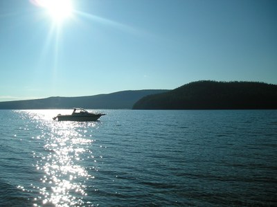
<p style="text-align: justify; "><strong>Mongolia</strong> has an extreme continental climate with significant fluctuations of daily and seasonal temperatures [7]. The winter is typically long and cold, while the summer is warm and short. The central and northern parts of Mongolia are elevated above the sea level by about 1,580 m. The region is mountainous and Khangai and Khentii mountains located here as well as the mountains around Lake Khuvsgul constitute part of Syberian Great Taiga. The weather is bright on most of the days (pic. 1.4.4).</p>
<p align="center"><img class="image-inline" src="../../../resolveuid/99dbdddf50d54070810d7876c5da8737/@@images/image/preview" /></p>
<p align="center">Pic. 1.4.4 The sun over Khuvsgul<i><span style="text-decoration: underline;"></span></i></p>
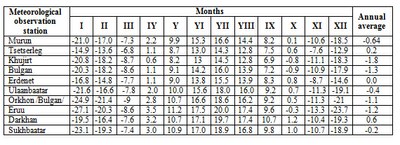
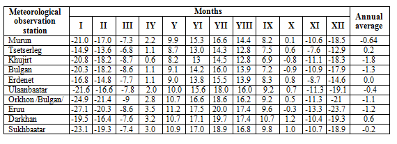
<p style="text-align: justify; ">In 2012, the maximum recorded temperatures were 38.1-31.4°C and were recorded near the Ider River, in Khuvsgul mountainous region, Darkhad depression, Orkhon and Selenge river basin area [8]. The coldest temperatures observed in Orkhon and Selenge river basin were between -43.9 and -38.1°C,  in Ider river basin, Khuvsgul Mountainous region and Darkhad depression the range was between -50.0 and -45.1°C, and from -41.5 to -32.5°C in other areas. The average air temperatures observed at meteorological stations in Selenge river basin are shown in table 1.4.4.</p>
<p style="text-align: center; ">Table 1.4.4 Monthly averages of air temperature, <sup>°</sup>С (by meteorological station)</p>
<p style="text-align: center; "><img class="image-inline" src="../../../resolveuid/70908db2e5744a0e986fece34b11ee6c/@@images/image/preview" /></p>
<p style="text-align: center; "><a href="http://bic.iwlearn.org/en/documents/photos/copy_of_4.jpg" class="internal-link">Open full size</a></p>
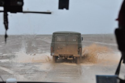
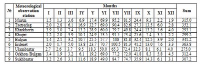
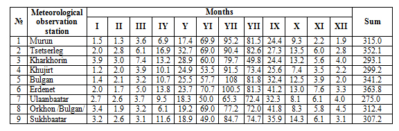
<p style="text-align: justify; ">The annual average precipitation is around 200-350 mm in Khangai, Khentii and Khuvsgul mountainous region and Orkhon and Selenge river basins (pic. 1.4.5) [8]. The sum of the monthly and total annual precipitation recorded at meteorological stations in Selenge river basin are shown in the table 1.4.5.</p>
<p align="center"><img class="image-inline" src="../../../resolveuid/1b086fdf150643c09375435f53312153/@@images/image/preview" /></p>
<p align="center">Pic. 1.4.5 Rain in the Orkhon River Basin</p>
<p style="text-align: center; ">Table 1.4.5 Monthly and Annual precipitation, mm (by meteorological station)</p>
<p style="text-align: center; "><img class="image-inline" src="../../../resolveuid/c4db861a2a5a453da3238bfbf4f016d3/@@images/image/preview" /></p>
<p style="text-align: center; "><a href="http://bic.iwlearn.org/en/documents/photos/copy_of_5.jpg" class="internal-link">Open full size</a></p>
<p style="text-align: justify; ">In 2012, the annual precipitation was 339.5-559.5 mm in Khuvsgul, Bulgan area and Orkhon and Selenge river basins. The surface water evaporation over the country is significant, particularly in forest steppe zones where evaporation reached 300-400 mm. In 2011, the annual average humidity was 64-79% in Khangai, Khentii and Khuvsgul mountainous region.</p>
<p style="text-align: justify; ">Annual average wind speed was 0.8-0.9 m/s in Bulgan area and 1.2-3.8 m/s in other areas, and the maximum wind speed reached 14 m/s in Jargalant area of Khuvsgul, Altanbulag area of Tuv aimag, and 15-34 m/s in other areas [8].</p>
<p style="text-align: justify; ">In Selengа River basin, prevailing winds change depending on the season. The winds from the north and west-north prevail in spring season (27%), winds from the east, north and west north are about 17-25% of winds in summer, while the east, west-north and south winds blow in autumn (16-20%). Winds from other directions are very rare. There are almost no winds in winter. In spring, summer and autumn, the average wind speeds are 3.0-6.9 m/s, depending on the direction. The annual average of wind speed is 2.7 m/s, not considering the direction.</p>
<p style="text-align: justify; "><strong>Climate </strong><strong>с</strong><strong>hange. </strong>According to Ulan-Ude weather station over 103 years the warming of the climate is estimated by the <i>air temperature</i> growth by 2.5° C (fig. 1). At the same time in Novoselenginsk the average annual air temperature rose by 1.8° C, while in Kyakhta it rose by 1.6° C [15].</p>
<p style="text-align: justify; ">Global changes reflect in the length of seasons (fig. 2). Increases of spring, summer and autumn and, consequently, decrease of the winter period were established. If in the early 1970s the length of seasons with positive and negative temperatures was approximately equal to 180-185 days, in the early 2000s the length of period with temperatures exceeding 0° C amount to over 200 days [15].</p>
<p style="text-align: justify; ">According to the data of the Limnological Institute of the Siberian Branch of the Russian Academy of Sciences annual air temperature growth at Lake Baikal (1.2° C over 100 years) turned out to be twice higher than the globe’s average (0.6° C). This corresponds to the known fact of intensification of warming pace from low to middle to high latitudes. It may be expected that the annual air temperature at Lake Baikal by 2025 will rise by 2° C, and by 2100 by 4° C [17].</p>
<p style="text-align: justify; ">Reconstruction of hydrological regime show that over the recent 250 years the <i>dynamics of precipitation</i> and water level did not undergo significant (trend) changes. A growth of winter temperatures has not yet led to a drastic changes of hydrological budget of the Transbaikalian territory, where natural changes prevail. [15]. Cyclicity is the most characteristic part of the longstanding regime of annual run-off of the rivers of the Baikal region and changes in atmospheric precipitation.</p>
<p style="text-align: justify; ">From the middle of the last century average duration of <i>snow cover</i> in Transbaikalia shortened approximately by 5 days. This was caused by an increase of warm period duration connected with the increase of air temperature. The most significant decrease of the duration of snow cover is observed in the regions adjacent to Lake Baikal. On the contrary, in eastern regions the increase prevails. At the same time some precipitation enhancement during the cold season of the year results in a growth of snow cover depth. A tendency to increase is exposed in the longstanding changes of snow cover depth by 2-4 cm in average since the mid-1960s [13].</p>
<p style="text-align: justify; ">Climate change influences<strong> </strong><i>ice conditions</i> on the lake. It is manifested in delayed freezing time and earlier breaking up of ice. At this time the change of freezing time in 1896-2000 was higher (by 11 days over 100 years) than for break up (7 days over 100 years) due to more active late autumn warming – early winter (November-December by 1.6° C) in comparison with the second half of spring (in April-May by 0.9°). The duration of an ice-free season increased, while that of the ice season decreased by 18 days. According to the observations, in 1949-2000 a maximum ice thickness in winter decreased by 2.4 cm over 10 years in average [16]. During the observation period from 1950 to 2007 a steady decrease of maximum ice-thickness on Lake Baikal amounts to 15-24 cm by different points. The duration of ice-formation decreased from 12 to 25 days for various areas of Lake Baikal and, consequently, the duration of ice-free period increased by 12-25 days [12].</p>
<p style="text-align: justify; ">According to forecasts the maximum ice-thickness on Lake Baikal will decrease to ~ 50 cm by 2050 and ~ 31 cm by 2100 [12]. Meanwhile the duration of ice season will decrease by 1 and 2 months respectively and by the end of the century will total 56-60 days on South and Middle Baikal and 76 days on North Baikal. It may be expected that in the end of the century in southern and middle areas of the lake there will be winters with short or unstable ice-formation [16].</p>
<p style="text-align: justify; ">The global warming affects <strong>Mongolia</strong> stronger in comparison with other regions of the globe. According to the data of 48 meteorological stations evenly spread on the territory of Mongolia, over past 70 years the average annual <i>temperature</i> in Mongolia rose by 2.14ºC. At the same time, in the period from 1990 to 2006 a small (-0.119ºC/year) temperature fall has been observed [18]. In the period from 1940-2004 winter air temperature rose by 3.6ºC, air temperature in spring rose by 1.4ºC, summer air temperature rose by 0.6ºC and autumn air temperature rose by 1.9º C. Climatic forecasts show that the territorial average monthly temperature of a warm season is expected to rise by 1.2-2.3º C in 2010-2039, by 3.3-3.6ºC in 2040-2069 and by 4.0-7.0º C in 2070-2099 [19].</p>
<p style="text-align: justify; ">Nowadays a gradual increase of evaporating capacity from the ground surface it taking place practically in all natural zones of Mongolia: in semi-arid and steppe and desert zone by 3.2-10 per cent, while in the highland and taiga areas by 10-15 per cent. Over the last 65 years the gross <i>precipitation</i> amount region-wise decreased by 8.7 – 12.5 per cent. Simultaneously, an annual redistribution of precipitation by seasons occurred. The winter precipitation amount rose while the precipitation amount in the warm season insignificantly fell. The amount of autumn precipitation rose by 5.2 per cent, winter precipitation rose by 10.7 per cent, while summer and spring rainfall, contrastingly, fell by 3.0 and 9.1 per cent respectively. This dynamics of humifying and the increase of the average annual temperature contributes to climate aridization  [18]. Changes in rainfall will fluctuate approximately within ± 4% or 6-17 mm in the course of 2010-2039 with the expected rise by 7-8 per cent (27-33 mm) in 2040-2069 [19].</p>
<p style="text-align: justify; ">According to the research data gathered over the recent years  changes in <i>ice formation</i> on rivers and lakes are concerned with the dates of ice cover formation and deterioration of condition and thickness of ice.</p>]]></content:encoded>
    <dc:publisher>No publisher</dc:publisher>
    <dc:creator>Zorigma</dc:creator>
    <dc:rights></dc:rights>
    <dc:date>2015-04-23T06:25:00Z</dc:date>
    <dc:type>Page</dc:type>
  </item>


  <item rdf:about="http://bic.iwlearn.org/en/documents/state-of-the-environment-report-the-lake-baikal-basin-1/general-conditions-of-the-baikal-lake-basin/1-3-specially-protected-natural-territories">
    <title>1.3 Specially protected natural territories</title>
    <link>http://bic.iwlearn.org/en/documents/state-of-the-environment-report-the-lake-baikal-basin-1/general-conditions-of-the-baikal-lake-basin/1-3-specially-protected-natural-territories</link>
    <description></description>
    <content:encoded xmlns:content="http://purl.org/rss/1.0/modules/content/"><![CDATA[<p align="center"><strong>1.3 Specially protected natural territories</strong></p>
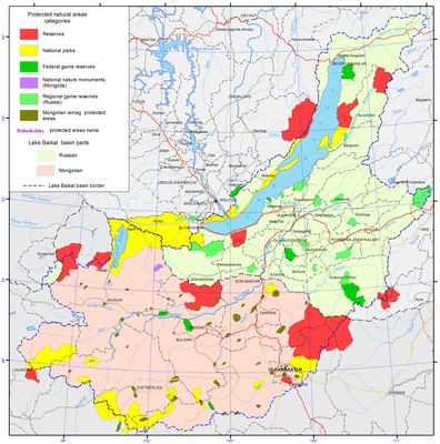
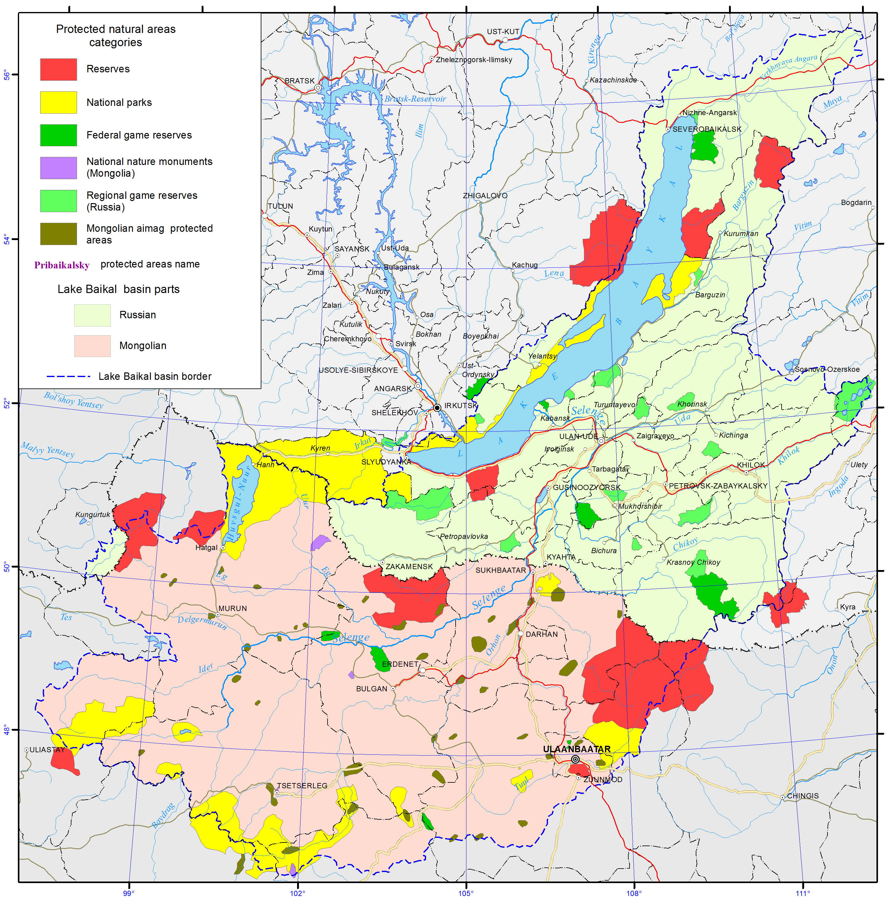
<p style="text-align: justify; ">At present, the Russian territory of the basin incorporates all the major categories of specially protected natural territories (SPNT) distinguished by the federal law «On specially protected natural territories» (1995): state nature reserves, national parks and wildlife sanctuaries of the federal and regional level as well as resorts and recreation locations, botanic gardens and monuments of nature (pic. 1.3.1) [3,4]. The total area of SPNT within Russian part of basin is 31252 km<sup>2 </sup>(data of the digital topographic basis of BINM SB RAS). In 2013, the number of reported violations in protected areas compared with 2012 increased by 29% and amounted to 1 110 violations.</p>
<p align="center"><img class="image-inline" src="../../../resolveuid/971455b4330b49c3ae96926ca34b5d8d/@@images/image/preview" /></p>
<p align="center"><a href="http://bic.iwlearn.org/en/documents/photos/1.3.1e.png" class="internal-link">Open full size</a></p>
<p align="center">Pic. 1.3.1 The specially protected natural territories [1]</p>
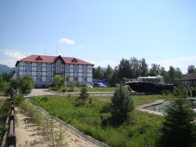
<p style="text-align: justify; "><strong>Reserves. </strong>Of the five state natural reserves three natural reserves are biospheric in accordance with the international UNESCO «Man and Biosphere» program: Barguzinsky (having a biospheric polygon), Baikalsky (pic. 1.3.2) and Sokhondinsky [3,4]. The boundaries of Barguzinsky reserve include a three-kilometer area along the coast of Lake Baikal. Sokhondinsky and Baikalsky reserves have protection zones – buffer territories, mitigating the transition from the strictly protected areas to the exploited areas. The reserves of the region preserve high-mountain taiga ecosystems: Baikal-Lena nature reserve preserves Baikal range; Barguzinsky reserve -Barguzinsky range, Baikalsky-Khamar-Daban mountains; Dzherginsky reserve – the juncture of Barguzinsky, Ikatskt and South-Muysky ranges; and Sokhondinsky reserve – Sokhondo mountains.</p>
<p align="center"><img class="image-inline" src="../../../resolveuid/2a591ba84bf34540b1642c33fc4d3c74/@@images/image/preview" /></p>
<p align="center">Pic. 1.3.2 The office of Baikal Reserve</p>
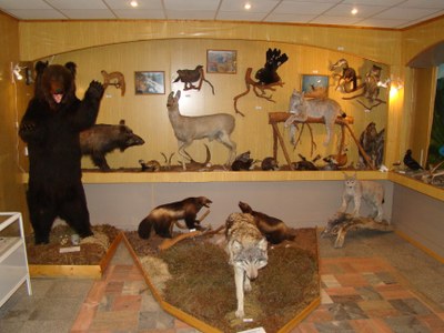
<p style="text-align: justify; ">The Baikal Natural Biospheric Reserve on the south coast of Lake Baikal is the major hub of the Eurasian ecological network and serves the research and nature conservation purposes. The biospheric reserve includes the Museum of Nature, which keeps its collection of animal and bird collection regularly updated (pic. 1.3.3).</p>
<p align="center"><img class="image-inline" src="../../../resolveuid/7a5b59411afb4091a30f4a588f41d12c/@@images/image/preview" /></p>
<p align="center">Pic. 1.3.3 The Museum of Nature of Baikal Reserve</p>
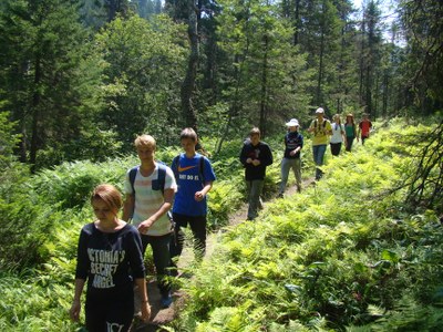
<p style="text-align: justify; ">The reserve also provides premises to the “Ethno-town” complex with a total area of 0.25 ha. In 2012, the museum managers conducted 61 excursions, while the number of museum visitors was 633 persons. The territory of the reserve is traversed with 6 ecological trails. The «Khamar-Daban Wilderness Trail» with a length of 12 km (2.5 km of which are within the protected area) passes through the Osinovka River and offers a good view of the bald mountain landscape. The path is reconstructed and maintained by volunteers of the «Great Baikal Trail Association» (pic. 1.3.4). The second excursion trail is designed as an ecological trail along the Vydrinnaya River and has a length of 44 km (22 km of which are outside the protected area). In 2012, the territory of the reserve and the protected area within it were visited by 357 groups of a total of 4 thousand people, as well as 25 foreign groups totally numbering more than 100 people.</p>
<p align="center"><img class="image-inline" src="../../../resolveuid/642baf5843fb486c9fd353cec2f602b3/@@images/image/preview" /></p>
<p align="center">Pic. 1.3.4 The Great Baikal Trail</p>
<p style="text-align: justify; "><strong>National parks. </strong>The region has four national parks being a type of specially protected natural territories more geared towards the development of tourism and recreational activities [3,4]. National parks are supposed to incorporate some of the following types of functional zones: a wilderness area, a specially protected area, a learning tourism area, a recreational area, and an area for historical and cultural objects. The functional zoning of national parks in Lake Baikal basin is different. For instance, in addition to the above-mentioned zones, Zabaikalsky National Park (pic. 1.3.5) has a defined water protection zone and a zone for traditional economic activities, where regulated fishing is allowed (6165 ha, or 2.7 %). Pribaikalsky park has a zone of traditional nature management (33 900 ha, or 8.1 %), but it does not have a specially protected area.</p>
<p align="center"><img class="image-inline" src="../../../resolveuid/35a42c223aa345078a1dfe2ebee190a5/@@images/image/preview" /></p>
<p align="center">Pic. 1.3.5 The Zabaikalsky National Park (Google)</p>
<p style="text-align: justify; ">The territory of Pribaikalsky national park stretches over 600 km as a narrow strip along the southwestern coast of Lake Baikal. The park is composed of clusters of five separated sections: Olkhon Island, mainland Olkhon district area, Maritime range and Baikal range. The boundaries of Pribaikalsky national park embrace about 40 locations as well as 112 thousand ha of agricultural lands, some of which are disputed. In terms of agricultural land disputes, the situation is relatively successful at Zabaikalsky national park. Its territory is compact and access is easily regulated. A 2011resolution of the Ministry of Natural Resources and Ecology of the Russian Federation stipulated merging of Barguzinsky state reserve and Zabaikalsky national park into a single entity under the official name of «Zapovednoe Podlemorye».</p>
<p style="text-align: justify; "><strong>Wildlife sanctuaries of the federal level. </strong>The territory of the three federation subjects have seven wildlife sanctuaries of the federal level, being located mainly on their peripheral part [3,4]. «Frolikhinskiy» wildlife sanctuary is situated on the northeastern coast of Baikal and on the western slope of Barguzinsky range. Lake Frolikha as a unique natural object, a habitat to endemic species of flora and fauna. Part of Lake Baikal coast, adjacent to the SPNT, belongs to the protected area of the sanctuary. The water-spa resort «Khakusy» is part of the wildlife sanctuary.</p>
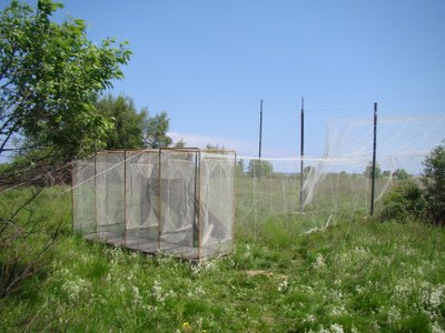
<p style="text-align: justify; ">«Kabansky» wildlife sanctuary is located in the Selenga river delta and is recognized as a structural part of Baikal biospheric reserve (pic. 1.3.6). The sanctuary incorporates aquatic and semi-aquatic complexes of multiple water channels and wetlands. This area is considered as an internationally significant territory with the status of «key ornithological territory» recognized by the Convention on the Conservation of Migratory Species of Wild Animals as well as the Convention on Wetlands of International Importance (Ramsar Convention). The reason for that is that the sanctuary is the major node on the migration trajectory of the birds of passage, many of which are numbered as rare or endangered species (pic. 1.3.6).</p>
<p align="center"><img class="image-inline" src="../../../resolveuid/e3b1ffd7129f444083d801d560484d78/@@images/image/preview" /></p>
<p align="center">Рис. 1.3.6  The trap for birds</p>
<p style="text-align: justify; ">«Altacheisky» wildlife sanctuary is at the confluence of the rivers Sulkhara and Khilok (right-hand tributary of the Selenga River) and represents a transition between middle-mountain pine forest and typical Selenga dry steppe area. The main protected species are roe deer, Siberian stag, bustard, demoiselle crane and Daurian hedgehog.</p>
<p style="text-align: justify; ">«Burkalsky» wildlife sanctuary is centrally located amid Khentei-Chikoi mountains and preserves cedar (Siberian larch) taiga. The population of Chikoi sable is endemic to this place, which unlike Barguzin sable has darker fur and is bigger in size.</p>
<p style="text-align: justify; "><strong>Wildlife sanctuaries of regional significance. </strong>Irkutsk region numbers 12 wildlife sanctuaries of regional significance (nine of them are of comprehensive character, while Zulumaisky, Irkutniy and Kochegarsky are species-oriented). In the Republic of Buryatia, there are 13 sanctuaries all of which have the status of «state natural biological» entities. In Zabaikalsky Krai there are 15 sanctuaries [3,4]. This category of SPNT is affiliated with the special departments of the executive power of the federation subjects. According to the federal legislation, such sanctuaries are established for a definite period, after which the decision on the prolongation or abolition is to be made. It should be noted that at present all the wildlife sanctuaries of Irkutsk region have been made to exist for an unlimited period of time. In Irkutsk region, some wildlife sanctuaries (Irkutniy, Magdansky, Kochergatsky and Boyskiy wetlands) have been functioning this way from 2003, while all other sanctuaries assumes the status in 2008. The Republic of Buryatia abolished time limits for wildlife sanctuaries in 2005, and Zabaikalsky Krai in February 2009.</p>
<p style="text-align: justify; ">Most of the wildlife sanctuaries of Irkutsk region cover river valleys and lake depressions of the middle-height mountains as hubs on the migratory routes of hoofed animals, nesting places of commercial birds, including semi-aquatic and swimming birds. In Buryatia, coastal SPNTs near Lake Baikal include Verkhne-Angarsky (the Kichera and Upper Angara river deltas), Pribaikalsky and Enkhelukskiy wildlife sanctuaries; high mountain-taiga type SPNTs include Muyskiy, Snezhinsky, and Ulyunsky (serves as a protection zone for Zabaikalsky national park); mountain-taiga SPNTs include Angirsky, Kizhinginsky, Kondinsky, Uzkolugsky, and Khudaksky sanctuaries; steppe SPNTs are Tugnuisky and Borgoisky. In Zabaikalsky Krai mountain-taiga sanctuaries include Atsynsky, Butungarsky, Nikishinsky, Uldurginsky and Chitinsky. A significant part of Ivano-Arakhleisky wildlife sanctuary is made up of lake and wetland complexes.</p>
<p style="text-align: justify; "><strong>Monuments of nature </strong>are the most numerous group of SPNTs, but these territories are insignificant in size and least protected legally [3,4]. In many cases, monuments of nature are seen as being supervised by non-existent organizations such as collective farms. Irkutsk region numbers 75 monuments of nature, including 4 of the federal level, 28 of the regional level and 43 of the local level. Out of the two latter groups, 23 monuments of nature are geological and geomorphological, 18 are hydrological, 9 are botanical, 4 are zoological, 5 are landscape monuments and 12 are complex. Monuments of nature also included archeological monuments, even though these objects are supervised by the state bodies responsible for the preservation of historical-cultural legacy but not by nature-protection bodies.</p>
<p style="text-align: justify; ">In the Republic of Buryatia, all the 152 monuments of nature have the regional status. The following types of them are distinguished: geological – 43, hydrological – 53, botanic – 19, zoological – 9, landscape – 19, complex (including natural-historical) – 9.</p>
<p style="text-align: justify; ">In Zabaikalsky Krai, the total number of monuments of nature of regional level is 66, including geological – 21, hydrological – 17, botanic – 9, zoological – 1, and complex (including recreational and natural-historical) – 18.</p>
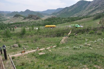
<p style="text-align: justify; "><strong>Mongolian</strong> Law on Specially Protected Areas provides for four categories of protected areas, such as «Strictly protected area» (SPA), «National conservation parks» (NCP) (pic. 1.3.1 and pic. 1.3.7), «Natural reserves» (NR) and «Monuments» (NM) [10].</p>
<p style="text-align: center; "><img class="image-inline" src="../../../resolveuid/83442e9e81e847a8a840e88278ff3722/@@images/image/preview" /></p>
<p align="center"><strong> </strong></p>
<p align="center">Pic. 1.3.7 The National conservation park Gorhi-Terelj</p>
<p style="text-align: justify; ">As of 2012, 99 locations covering 27.2 million ha are considered as specially protected areas. These areas occupy 17.4% of the country’s total territory and are to be further expanded to reach 30%. According to the classification of the specially protected areas, there are 20 Strictly Protected Areas occupying 12 402 429 ha of land, 32 Natural Conservation Parks spanning over 11 711 815 ha, 34 Natural Reserves covering 2 958 142 ha, and 13 Monuments over 126 848 ha. Mongolian Government further increases the number of Specially Protected Areas year by year [11].</p>
<p style="text-align: justify; ">Eleven Mongolian lakes and the areas surrounding them (wetlands, meadows, etc.) are registered under RAMSAR convention [14,24]. Among these, Lake Ugii (47º46’N 102º46'E) located in Ugii soum and Lake Terhyn Tsagaan (48°10'N, 99°43'E) located in Tariat soum of Arkhangai aimag were registered under RAMSAR convention in 1998.</p>
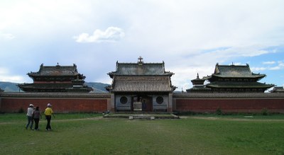
<p style="text-align: justify; ">The Orkhon valley with its numerous archaeological remains dating back to the 6th century was recognized as a World Heritage Site by UNESCO in 2004 [9]. Collectively the remains within the valley reflect the symbiotic links between nomadic, pastoral societies and their administrative and religious centers, and the importance of the Orkhon valley in the history of central Asia. The site includes Kharkhorum, the 13th- and 14th-century capital of Chingis (Genghis) Khan’s vast Empire (pic. 1.3.8). Within the cultural landscape are a number of archaeological remains and standing structures, including Turkic memorial sites of the 6th-7th centuries, the 8<sup>th</sup>-9th centuries’ Uighur capital of Khar Balgas. Erdene Zuu, the earliest surviving Mongol Buddhist monastery, Tuvkhun Hermitage, etc.</p>
<p align="center"><img class="image-inline" src="../../../resolveuid/d3f540cdc1944a0e972916a6371a86e7/@@images/image/preview" /></p>
<p style="text-align: center; ">Pic. 1.3.8 The modern Erdenezuu in Kharkhorin</p>]]></content:encoded>
    <dc:publisher>No publisher</dc:publisher>
    <dc:creator>Zorigma</dc:creator>
    <dc:rights></dc:rights>
    <dc:date>2015-04-23T06:06:23Z</dc:date>
    <dc:type>Page</dc:type>
  </item>


  <item rdf:about="http://bic.iwlearn.org/en/documents/state-of-the-environment-report-the-lake-baikal-basin-1/general-conditions-of-the-baikal-lake-basin/1-2-territorial-administrative-division">
    <title>1.2 Territorial-administrative division</title>
    <link>http://bic.iwlearn.org/en/documents/state-of-the-environment-report-the-lake-baikal-basin-1/general-conditions-of-the-baikal-lake-basin/1-2-territorial-administrative-division</link>
    <description></description>
    <content:encoded xmlns:content="http://purl.org/rss/1.0/modules/content/"><![CDATA[<p style="text-align: center; "><strong>1.2 Territorial-administrative division </strong></p>
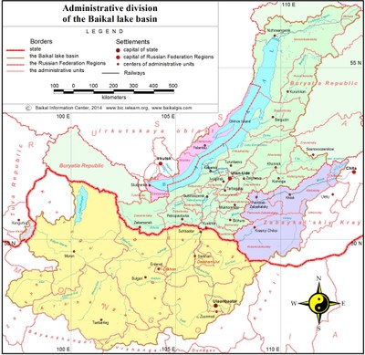
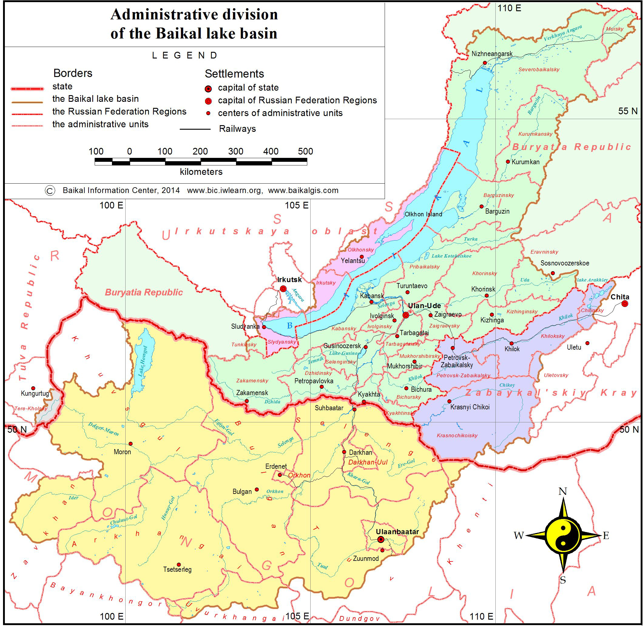
<p style="text-align: justify; "><span>Administratively, the transboundary basin of Lake Baikal is situated on the territories of two states – Russian Federation and Mongolia (pic. 1.2.1).</span></p>
<p align="center"><img class="image-inline" src="../../../resolveuid/30fca3c6da87485c901866cefb279b5b/@@images/image/preview" /></p>
<p style="text-align: center; "><a href="http://bic.iwlearn.org/en/documents/photos/1.2.1e.jpg" class="internal-link">Open full size </a></p>
<p align="center">Pic. 1.2.1 Administrative division of Lake Baikal basin</p>
<p style="text-align: justify; ">The total area of the basin is 576,5 thousand km<sup>2</sup>, of which 44,6 %<sup> </sup>are in Russia and 55,4 % are in Mongolia [20]. The Russian part of the basin incorporates the territory of four administrative units (federation subjects) of the Siberian federal district and in Mongolia – the territory of 12 aimags.</p>
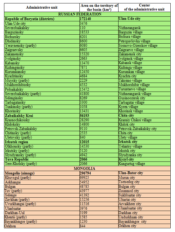
<p style="text-align: justify; ">In terms of the administrative division, the south-eastern part of Lake Baikal basin belongs to Zabaikalsky Krai (ZK), the central and northern parts – to the Republic of Buryatia (RB) and the western part – to Irkutsk region (IR). On the side of Irkutsk region, the region includes Olkhon district with the biggest island on Lake Baikal and the shore territories of Irkutsk (north of the Angara River) and Slyudyanka districts. From the north-eastern part of Lake Baikal, the lake basin incorporates the following administrative districts of RB: Severobaikalsky, Barguzinsky, Kurumkansky district, the western part of Muysky district and Pribaikalsky district. A considerable part of the territory is part of the Central ecological zone of Baikal natural territory (BNT). The central part of the basin of Lake Baikal in RB includes 15 municipal units: Ulan-Ude city, Bichursky district, Dzhidinsky district, Zaigraevsky, Ivolginsly, Kabansky, Kizhinginsky, Kyachtinsky, Mukhorshibirsky, Selenginsky, Tarbagataisky, Khorinsky, Zakamensky districts, parts of Yeravnensky and Tunkinsky districts.</p>
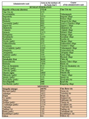
<p style="text-align: justify; ">The western part of Lake Baikal basin is represented by ZK and includes 5 administrative districts: Krasnochikoisky, Petrovsk-Zabaikalsky, Khiloksky districts, part of Chitinsky and Uletovsky districts, located in the tributary area of the Khilok and Chikoi rivers (table 1.2.1).</p>
<p style="text-align: center; ">Table 1.2.1 Administrative units of Lake Baikal basin</p>
<p style="text-align: center; "><img class="image-inline" src="../../../resolveuid/17b0b5cebf7d4bbebf56d9d7e10cb849/@@images/image/preview" /></p>
<p style="text-align: center; "><a href="http://bic.iwlearn.org/en/documents/photos/copy2_of_1.jpg" class="internal-link">Open full size</a></p>
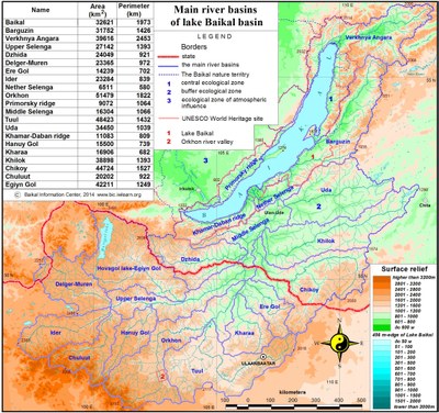
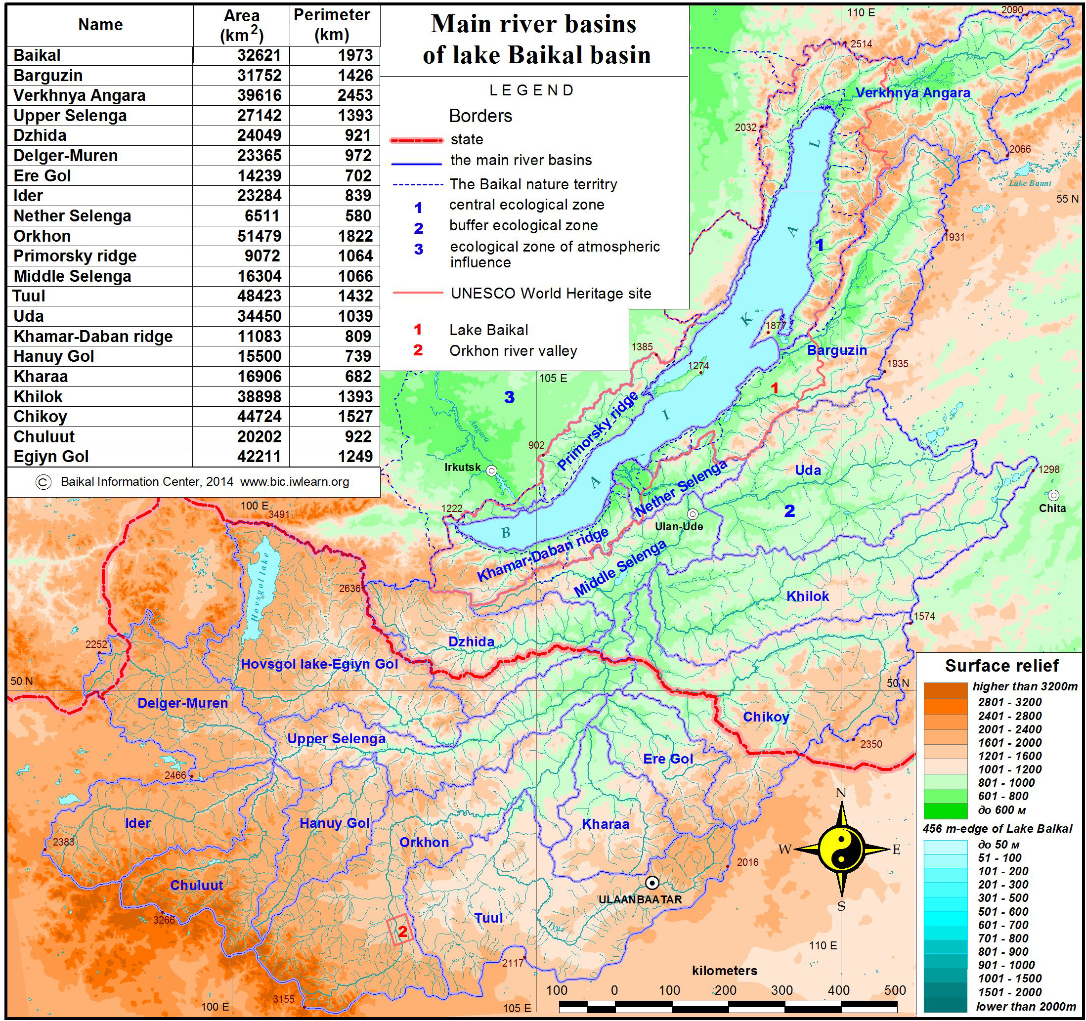
<p style="text-align: justify; ">The Russian territory of the basin is part of Baikal natural territory (BNT), divided into three ecological zones [5,6]. The central ecological zone covers the water area and the shore of the lake. Ecological buffer zone is coextensive with the Russian part of the lake basin. The zone of atmospheric effect occupies the eastern part of Irkutsk region, adjoining the western border of the basin (pic. 1.2.2).</p>
<p align="center"><img class="image-inline" src="../../../resolveuid/adcd33fc05ab47748475a8cbede896b8/@@images/image/preview" /></p>
<p align="center"><a href="http://bic.iwlearn.org/en/documents/photos/1.2.2e.jpg" class="internal-link">Open full size</a></p>
<p style="text-align: center; ">Pic. 1.2.2 Basins of the major rivers of Lake Baikal basin</p>]]></content:encoded>
    <dc:publisher>No publisher</dc:publisher>
    <dc:creator>Zorigma</dc:creator>
    <dc:rights></dc:rights>
    <dc:date>2015-04-23T03:49:17Z</dc:date>
    <dc:type>Page</dc:type>
  </item>


  <item rdf:about="http://bic.iwlearn.org/en/documents/state-of-the-environment-report-the-lake-baikal-basin-1/general-conditions-of-the-baikal-lake-basin/physical-and-geographical-position">
    <title>1.1 Physical and geographical position</title>
    <link>http://bic.iwlearn.org/en/documents/state-of-the-environment-report-the-lake-baikal-basin-1/general-conditions-of-the-baikal-lake-basin/physical-and-geographical-position</link>
    <description></description>
    <content:encoded xmlns:content="http://purl.org/rss/1.0/modules/content/"><![CDATA[<p style="text-align: center; "><span>1.1 Physical and geographical position</span></p>
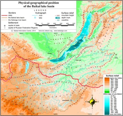
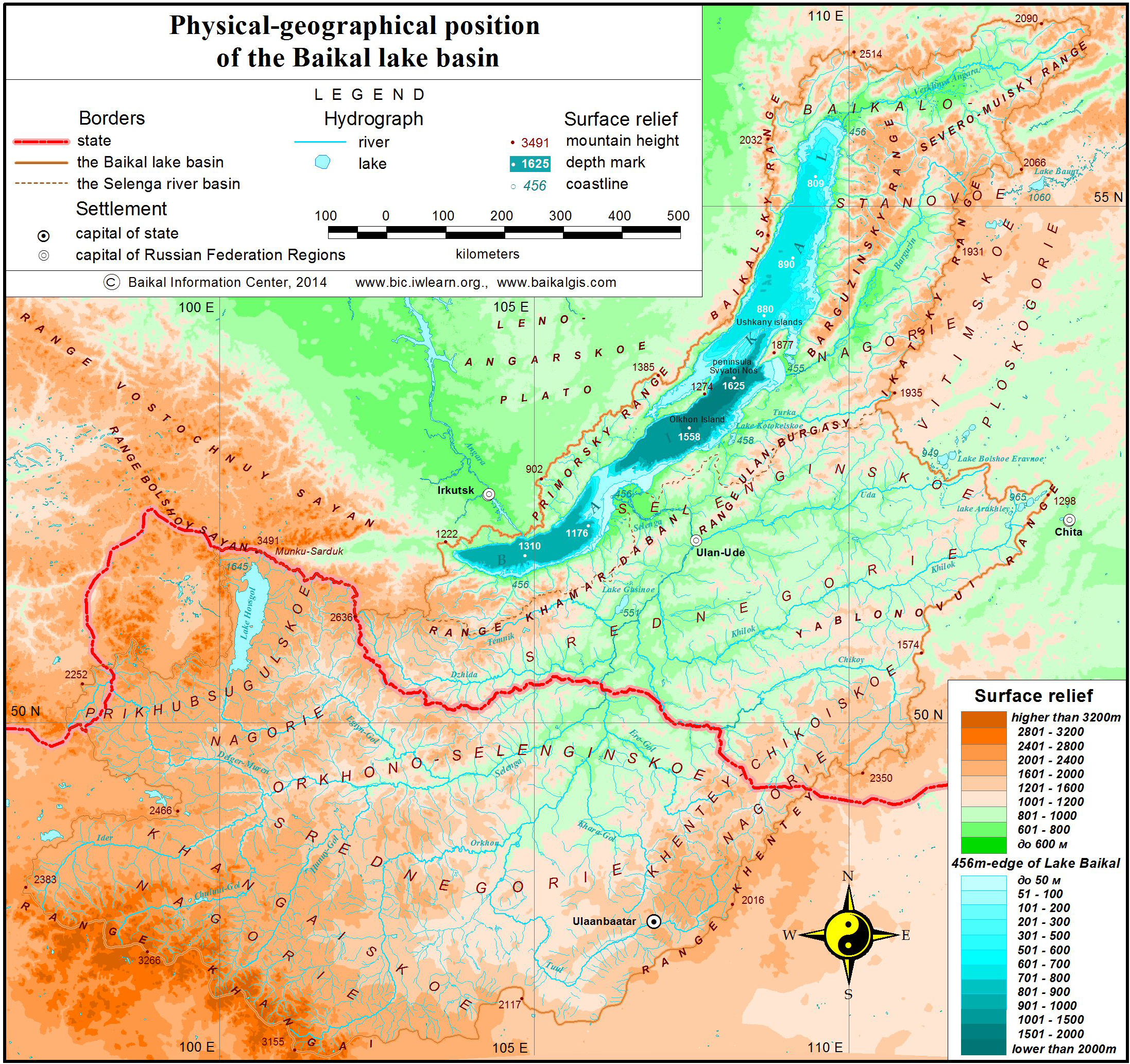
<p style="text-align: justify; ">The transboundary basin of Lake Baikal is located on the boundary of North and Central Asia between 46º 28′ and 56º 42′ in the north-south direction and between 96º 52′ and 113º 50′ in the west-east direction. The longest stretch of the basin from south-west to north-east is 1470 km, from west to east it is 962 km, and its minimal length from west to east is 193 km. In the north, the basin is conterminous with the Lena river basin, bounded by the mountain range of Synnyr, Verkhneangarsk and Delun-Uransky. In the east, it is bounded by the Vitim uplands and the border is formed by the Ikatskiy mountain range. In the south-east, it borders the Amour river basin, where the water divide is constituted by the Yablonovy mountain range and is coextensive with the World watershed, separating surface waters of the Arctic Ocean and the Pacific Ocean, extending into the Khentei Mountains (World watershed). In the south, the basin is bounded by the inland drainage area of North Mongolia, while its south-western border is the formed by the Khangai range (World watershed). In the west, it is conterminous with the upper stream of the Yenisei and Lena rivers. At this point, the watershed line is coextensive with the state border and the Khangarulsky range, traversing the Khamar-Daban Mountains and reaching the outlet of the Angara River along the shore of Lake Baikal, extending along the Primorski and Baikal ranges (pic. 1.1.1).</p>
<p style="text-align: center; "><img class="image-inline" src="../../../resolveuid/a335d9919c30434ca541341d4c4b7228/@@images/image/preview" /></p>
<p style="text-align: center; "><a href="http://bic.iwlearn.org/en/documents/photos/1.1.1e.jpg" class="internal-link">Open full size</a></p>
<p align="center">Pic.  1.1.1  Physical and geographical position of Lake Baikal</p>
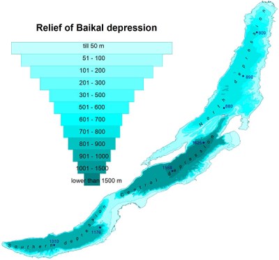
<p style="text-align: justify; ">The territory of Lake Baikal is considerably elevated above sea level and is characterized with mid-mountain relief. The lowest elevation point is that of Lake Baikal - 456 m (Baltic system of altitude), and its highest point is Munku-Sardyk (3491 m). The land surface of the region is the ancient folded area, encompassing huge mountain ranges and vast, deep and in some cases isolated intermountain depressions. It is composed of ancient crystalline rocks, which are in some sections (predominantly in tectonic depressions) covered with a comparatively small (up to 0.5-2 km) layer of Mesozoic and Cenozoic deposits. Regional tectonics structure exerts considerable influence on the formation of relief and the regime of surface and ground waters. The rift area is the major element of the basin, incorporating the northern, central and southern depressions, filled with water and constituting the single Baikal depression (pic. 1.1.2). It is surrounded by mountain ranges, has a crescent-like form and stretches from the south-west to the north-east. The length of the lake is 636 km, and its width varies from 25 to 80 km. The average depth of the lake is 758 m, while its maximum depth is 1637 m.</p>
<p style="text-align: center; "><img class="image-inline" src="../../../resolveuid/d4464d3140b54691b2a169b719e3d21d/@@images/image/preview" /></p>
<p align="center">Pic 1.1.2  Relief of Baikal depression</p>
<p style="text-align: justify; ">Flat surfaces on the territory of the basin can only be found in tectonic depressions and the valleys of big rivers, which can in turn be divided into two major types - intramountanous (depressions of Baikal type) and intermountanous (depressions of Trans-Baikalian type) [1]. The depressions of Baikal type (Baikal, Verkhneangarsk, Barguzin, and Khuvsgul), formed as a result of curved deformation of the earth crust, are comparatively deep and large in size. Their northern and north-western sides are usually steeper. The depressions are filled with Cenozoic sediments, accumulated under the conditions of crustal warping. It is for this reason that rivers, flowing across this territory, have well-shaped and broad flood plains. The most significant of them is the one of Lake Baikal as well as Verkneangarsk and Barguzin depressions.</p>
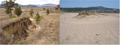
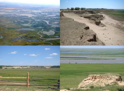
<p style="text-align: justify; ">The depressions of Trans-Baikalian type have predominantly a tectonic and erosion-accumulative origin, while their number is more than 50 (Gusinoozerk, Ust-Selenginsk, Tugnui-Sukharisnk, Ivolginsko-Udinsk etc). They are surrounded by plateau mountains, which have at their base flattened and gently rugged foothills, separated by proluvian valleys. The submontane strips of the valleys embrace isolated mountains, low conic hills and small mountain groups. Some sections of the Selenga basin at the sabulous and sandy sites incorporate a dense network of ravines and are dominated by the eolian relief (dunes and deflation basins) (pic. 1.1.3).</p>
<p style="text-align: center; "><img class="image-inline" src="../../../resolveuid/c90236c57f774467b1186767450e8edf/@@images/image/preview" /></p>
<p align="center">Pic. 1.1.3  Elements of eolian relief in Ivolginsk-Udinsk depression: ravines and deflation basins</p>
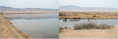
<p style="text-align: justify; ">Mid-level and high terrains in the Trans-Baikalian depressions are gone, low terrains are composed of gravel and sandy soil, while the terrain steps, cut by rivers, as well as subaerial deltas of tributaries and foothill shelves are composed of sandy and sabulous material. Trans-Baikalian depressions include the big fresh-water Lake Gusinoe – the third biggest lake in the basin in the center of Gusinoozersk depression, as well as the major rivers of the area (pic. 1.1.4).</p>
<p style="text-align: center; "><img class="image-inline" src="../../../resolveuid/d59574512efb4a9b93d8822d471e6af5/@@images/image/preview" /></p>
<p align="center">Pic. 1.1.4 Lake Gusinoe</p>
<p style="text-align: justify; ">Of special significance is Ust-Selenginsk depression, located in the tectonic downwarp area, protruded into the south-eastern shore of Baikal rift zone (pic. 1.1.5).  It is characterized with active neotectonic processes. The depression is filled with a huge layer of loose sediments, while its ground waters are connected with Lake Baikal water by a hydraulic way at the depth of 200-250 m.</p>
<p style="text-align: center; "><img class="image-inline" src="../../../resolveuid/9b954bb1d97a45989dc9b7275e7a39fd/@@images/image/preview" /></p>
<p align="center">Рic. 1.1.5  Ust-Selenginsk  depression</p>
<p style="text-align: justify; ">According to the geographic zoning scheme of IG SB RAS, the northern part of Lake Baikal basin is situated on the territory of Baikal  Dzhugdzhursky mountain-taiga area, the middle part – on the territory of South-Siberian mountain area and its southern part – on the territory of North-Mongolian semi-desert and grassland area [2]. The relief of the basin territory is constituted by the following geomorphological formations:</p>
<p>1. Baikal-Stanovoe uplands;</p>
<p>2. Selenga middle mountains;</p>
<p>3. Orkhon-Selenga middle mountains</p>
<p>4. Khentei-Chikoi uplands;</p>
<p>5. Lake Khuvsgul uplands;</p>
<p>6. Khangai uplands.</p>
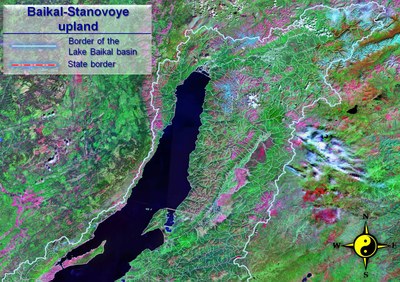
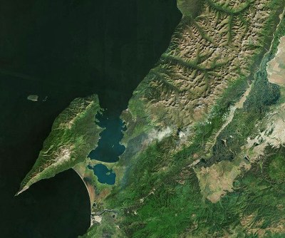
<p style="text-align: justify; "><strong>Baikal-Stanovoe uplands </strong>incorporate those parts of the Siberian platform which are highly elevated and greatly dissected as a result of neotectonic movements. The heights of some mountain ranges range between 2000-2500 m, while the elevation of the depression bottom above sea level is 456 – 600 m. The highlands have significant traces of mountain-valley glaciation with the glacial forms of relief and a great number of lakes (pic. 1.1.6).</p>
<p style="text-align: center; "><img class="image-inline" src="../../../resolveuid/8cc02284a1894e88ac7c736415bf0c1b/@@images/image/preview" /></p>
<p align="center">Pic. 1.1.6 Baikal-Stanovoe uplands (Landsat space image)</p>
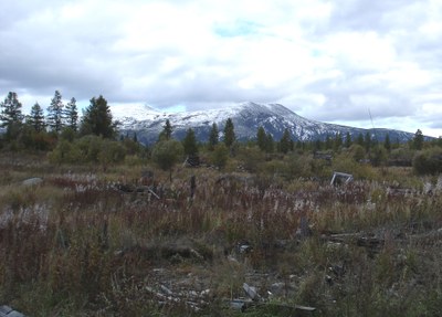
<p style="text-align: justify; ">In the west, Baikal depression is bounded by the Primorsky range (with the heights ranging between 1100-1700 m), which does not have clear-cut water divide, but rather softly-shaped or flat peaks with incised valleys. To the north-east lies the heavily dissected Baikal range with mountain heights of 2000-2500 m. To the north, broadening in width to 80-100 km, it grows into the Ungdar highlands.  Starting from the highlands, Verkhneangarski mountain range runs in the north-eastern direction (above 2000 m) (pic. 1.1.7) [3].</p>
<p style="text-align: center; "><img class="image-inline" src="../../../resolveuid/2e504e8657f04994a606bb798759593e/@@images/image/preview" /></p>
<p align="center">Pic. 1.1.7 Verkhneangarski range</p>
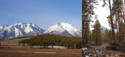
<p style="text-align: justify; ">In the east, parallel to the northern part of Baikal depression, run the Barguzin and Ikatsky ranges, between which lie Barguzin depression. The Barguzin range is the highest one among the highlands in the region (the height of some peaks reaches 2500-2840 m). Its distinctive feature is a strongly pronounced asymmetry: its southeastern slopes end abruptly towards Barguzin depression, and northwestern slopes run gradually to Lake Baikal (pic. 1.1.8).</p>
<p style="text-align: center; "><img class="image-inline" src="../../../resolveuid/5cd81d8628124ba4add368b00a48e32c/@@images/image/preview" /></p>
<p align="center">Pic. 1.1.8 Spurs of Barguzinsky range</p>
<p style="text-align: justify; ">Barguzin depression has the length of about 200 km, while its maximum width is 25-35 km. The bottom of the depression is characterized by a flat relief (with elevation of 470-600 m), at the foot of which runs a foothill terrace.</p>
<p style="text-align: justify; ">The southern part of the range belongs to the zone of the specific Trans-Baikalian pine-larch (more rarely – birch) mountainous forest-steppes. The northern part of the upland is a typical mountain-taiga area.</p>
<p style="text-align: justify; ">The whole territory is a permafrost area. The southern part of the depression belongs to the zone of insular permafrost, while the northern (in particular the intermountain basins) – to the glaciation zone with the width of up to 120 m. The upland is characterized by increased tectonic activity and high seismicity.</p>
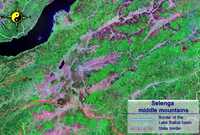
<p style="text-align: justify; "><strong>Selenga middle mountains </strong>are a huge lowered area between the Khamar-Daban, Ulan-Burgasy and Khentei-Chikoi ranges and bounded by the water divide of the Selenga basin (pic. 1.1.9) [1]. The peneplainized Khamar-Daban is a relatively flat plateau with the elevation of up to 1500 m, has the direction from the south-west to the north-east. The more prominent elements are massive round-shaped tops, exceeding 2700 m above sea level. To the south lies the middle-mountain Minor Khamar-Daban with the heights below 1700-1800 m, being heavily dissected by the many tributaries of the Dzhida River. The Dzhida range, made up of mid-level mountains with the maximum elevation of 1612 m above sea level, extends in the west as far as the Selenga river valley.</p>
<p style="text-align: center; "><img class="image-inline" src="../../../resolveuid/798a5039e7d840cb8a0b13621080c1f7/@@images/image/preview" /></p>
<p align="center">Pic. 1.1.9 Selenga middle mountains (Landsat space image)</p>
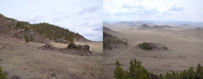
<p style="text-align: justify; ">The relief of the territory incorporates a considerable number of open, isolated and half-isolated depressions of Trans-Baikalian type, alternating with vast flat-topped ranges slightly varied in height (1300-1800 m). The intermountain depressions of Trans-Baikalian type are comparatively shallow, stretching in the same direction as the mountain ranges. The bottom of the depressions is at about 550-700 m above sea level in the western and central parts, and 700-850 m in the eastern part. The elevation fluctuates within 500-900 m. The depressions are relatively small in size, but their total area is rather large (pic. 1.1.10).</p>
<p style="text-align: center; "><img class="image-inline" src="../../../resolveuid/235aff9d7b1547818af068fe0a63cdaa/@@images/image/preview" /></p>
<p align="center">Pic. 1.1.10 Tugnuy-Sukharinskaya depression</p>
<p style="text-align: justify; ">Since intermountain depressions are bounded by the Khamar-Daban in the west, and the Khentei-Chikoi range in the east, and are open to the south, they receive just a small amount of precipitation, while their snow cover is thin and is not always formed in the driest regions.</p>
<p style="text-align: justify; ">The piedmont river fans, occupying a considerable part of the depressions’ bottom, have in their western section steppe and dry-steppe environment, and in their eastern section – forest and steppe environment. The more widely distributed are dry sod grasslands on chestnut soil and less widely distributed – bunchgrass steppe as well as forb and grassland on leached chernozem. The grassland belt has the elevation of up to 900-1000 m, forest and grassland – from 900-1000 to 1200 m. The lowest belt of the vertical zonation is the grassland-forest of the Selenga delta.</p>
<p style="text-align: justify; ">The bottoms and slopes of the depressions house dry pine forests. Considerable in size, the fluvial meadow plains and terraces as well as meadow-swamp plains are characterized by salination. The slopes of the ridges, facing south, are commonly covered by pine and pine-larch south-taiga forests, which include meadow-grassland plots – “uburs”. The northern slopes are grown by larch taiga, while the upper sections of the slopes (at the elevation of 1400-1600 m) one can find larch-cedar and cedar taiga. The middle mountains of the Selenga are the most economically advanced region of Lake Baikal basin.</p>
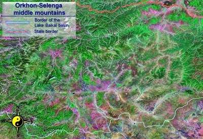
<p style="text-align: justify; "><strong>Orkhon-Selenga middle mountains </strong>(Orkhon-Selenga erosion mountains)<strong> </strong>occupy a transitory area of the depression, located between the Khantai and Khentei-Chikoi mountains [4]. Territorially, this depression is coextensive with the heavily dissected basins of the Selenga and Orkhon rivers. The total length of the Orkhon-Selenga Mountains from east to west is about 1000 km, and its width – 300-350 km. This vast area consists for the most part of orographically branched and predominantly low mountains with unequal height. The area is dominated by low and narrow heavily flattened ridges and hills, separated by wide intermountain depressions and river valleys (pic. 1.1.11).</p>
<p style="text-align: center; "><img class="image-inline" src="../../../resolveuid/87f09f676c5b4e339d33214aec4da07a/@@images/image/preview" /></p>
<p align="center">Pic. 1.1.11 Orkhon-Selenga middle mountains (Landsat space image)</p>
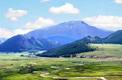
<p style="text-align: justify; ">The average height of the Orkhon-Selenga mountains is 1500-2000 m, and their maximum height is 2132 m (the Khantai range), while the bottom of depressions and valleys reaches the elevation of 800-1200 m. The landscape of low and heavily destructed mountains is dominated by the big range of the Khantai, Bulgan-Khan, Burin-Nuru and Burelyin-Nuru, with the heights up to 1600-2000 m. They occupy the extreme northeastern part of the Orkhon-Selenga mountains, adjacent to the Khentei range and extending in the same north-eastern direction. The other part of the Orkhon-Selenga mountains, gravitating towards the Khangai range, is considerably lower in elevation and is composed of heavily dissected low-height massifs, ridges and mountains (pic. 1.1.12).</p>
<p style="text-align: center; "><img class="image-inline" src="../../../resolveuid/a3513280207e4d869dd32193459e3472/@@images/image/preview" /></p>
<p align="center">Pic. 1.1.12 The Suvarga Khairkhan mountain, origin of the Orkhon River</p>
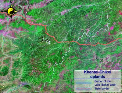
<p style="text-align: justify; "><strong>Khentei-Chikoi uplands </strong>are on the Russian-Mongolian border and, for the most part in north-eastern Mongolia, where the ranges and depressions do not have considerable length [4].<strong> </strong>Khentei-Chikoi uplands are typical low and flattened vault-like uphills with the barren relief on top of the vault (pic. 1.1.13).</p>
<p style="text-align: center; "><img class="image-inline" src="../../../resolveuid/64391cd29b6f4f0585e4f81d84c10d6c/@@images/image/preview" /></p>
<p align="center">Pic. 1.1.13  Khentei-Chikoi uplands (Landsat space image)</p>
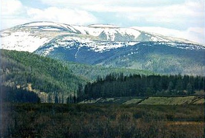
<p style="text-align: justify; ">This area lacks the single pronounced orographic core, but instead has a zone of bald mountains which assume the functions of the orographic core. The latter takes up the most elevated central part of the highlands, located in the upstream of the Onon, Tuul, Iro, Kherlen and Menza rivers. The bare mountains and ridges are commonly huge and have round-shaped or flattened tops, while their slopes, round-shaped and asymmetric, are covered with stones (pic. 1.1.14).</p>
<p style="text-align: center; "><img class="image-inline" src="../../../resolveuid/6935c4db1d854df783407540b003ca10/@@images/image/preview" /></p>
<p align="center">Pic. 1.1.14  Khentei mountain range</p>
<p style="text-align: justify; ">Of particular interest is the fluvial network of the highlands. Even though the rivers, originating in the barren mountains, flow in different directions, but none of them flows beyond their realm to the south – drainless Central Asian basin. All of them flow either into the basin of the Arctic Ocean, or the basin of the Pacific Ocean. Apart from that, some of them form abrupt and characteristic meanders and loops close to the boundaries of the drainless basin (Tuul, Kherlen). The world water divide in Khentei is not always coextensive with the maximum relief elevation, being second to the local water divides and forming a sinuous line.</p>
<p style="text-align: justify; ">The area is dominated by mountain taiga.  The lower sections of the hills are taken by larch forests with the underwood of Rhododendron dauricum. At the heights, exceeding 1200-1300 m, larch forests are supplanted by cedar and larch forests. Purely cedar forests are rare and found predominantly at upper edges of mountainous taiga and damp places. At the height of 1700-1800 m, the sparse forest and barren mountains come to the fore. The upper stream of the Chikoi River has separate sites, the formation of which has been facilitated by glaciers. The most elevated places may have snow fields. The highlands also have permafrost of the island type.</p>
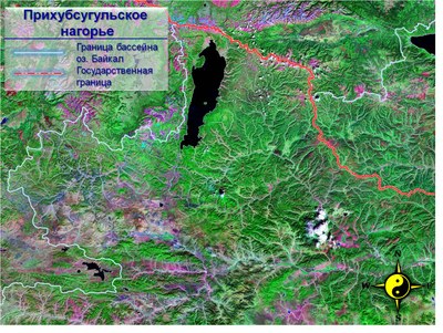
<p style="text-align: justify; "><strong>Lake Khuvsgul uplands</strong> form the southwestern node in the system of Baikal rift, ending without further visible extension [4]. The highlands protrude deeply into the mountain systems of Tuva and Eastern Sayans, forming a complex structural and orographic node, connecting their spurs with the spurs of the Khangai (pic. 1.1.15).</p>
<p style="text-align: center; "><img class="image-inline" src="../../../resolveuid/2db30efeaabf4911adc93e691d7bad64/@@images/image/preview" /></p>
<p align="center">Pic. 1.1.15 Lake Khuvsgul uplands (Landsat space image)</p>
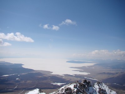
<p style="text-align: justify; ">Khuvsgul uplands are represented by a number of mountain ranges and intermountain depressions, occupied by the valley of the Uree-Gol River, Lake Khuvsgul depression and Darkhat depression. The position of these depressions and ranges is strictly conditioned by submeridional rift, cutting across the extension of the sublatitudinal formations of Khangai mountains. Lake Khuvsgul serves as the orographic center of the area (pic. 1.1.16).</p>
<p style="text-align: center; "><img class="image-inline" src="../../../resolveuid/dd8677bc61a84e06b247eff4263370a7/@@images/image/preview" /></p>
<p align="center">Pic 1.1.16 Lake Khuvsgol</p>
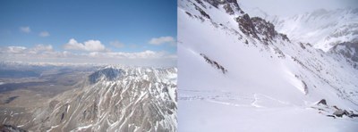
<p style="text-align: justify; ">North of the lake runs the borer-area range of Munku-Sardyk, whose tops are permanently covered with snow and small modern glaciers. Along the western shore of lake Khuvsgol lie the huge and hard-to-access ranges of Bayan-Ula (3002 m) and Khardyl-Sardyk (3189 m), forming the boundary of the basin here. For the most part they exceed the elevation of 2000 m and have a relative elevation up to 500 m. Lake Khuvsgul rift area is the only mountainous area in Mongolia, which has a well pronounced Alpine relief (pic. 1.1.17).</p>
<p style="text-align: center; "><img class="image-inline" src="../../../resolveuid/aef686c1eb354fedabde3065803c8150/@@images/image/preview" /></p>
<p align="center">Pic. 1.1.17 Top of Munku-Sardyk</p>
<p style="text-align: justify; ">The slopes of the ranges, facing Lake Khuvsgul (Bayan-Ula range) and Darkhad depression (Khardyl-Sardyk range), form high and steep stone benches with the relative high elevation of up to 500-1000 m over Lake Khuvsgul. The southern part of the area has a mid-mountain relief, characterized with relatively flat tops of dividing ranges, comparatively flat and smooth slopes and wide valleys.</p>
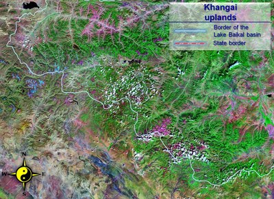
<p style="text-align: justify; "><strong>Khangai uplands </strong>are located in the southern part of the basin, forming the peculiar inland mountains of Mongolia. In the west, their slopes stop at the Great Lakes Depression, and in the south and the southeast at the Valley of the Lakes and the Central Gobi pereplain (pic. 1.1.18) [4]. The boundaries of the mountain area are clear-cut and distinct, conditioned by the deep faults of Dzabkhansky and Bayankhongorsky. The transition to valleys is marked either with benches, or the ridges of low mountains and hummocks, protruding deeply into their realm.</p>
<p style="text-align: center; "><img class="image-inline" src="../../../resolveuid/2a1c3bb0b986446bbe1315fa153a85bc/@@images/image/preview" /></p>
<p align="center">Pic. 1.1.18 Khangai mountains (Landsat space image)</p>
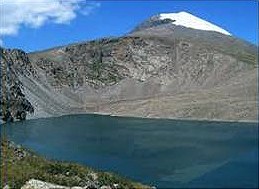
<p style="text-align: justify; ">The orographic core of the area is its main water divide range, which stretches in the northwestern direction for 700 km and is coextensive with the World water divide. It reaches the maximum elevation in the west, where there is the most powerful mountain plexus with the well-preserved ancient glacial relief. The largest of them is the mountain group of Otgon-Khairkhan-Nuru. Its top Otgon-Tenger, 4008 m high, permanently covered with snow, is the highest mountain of the Khangai (pic. 1.1.19).</p>
<p style="text-align: center; "><img class="image-inline" src="../../../resolveuid/89960c6d4a7a47d6947d9f7f806832cb/@@images/image/preview" /></p>
<p align="center">Pic. 1.1.19 The Otgon Tenger Mountain, origin of the Ider River</p>
<p style="text-align: justify; ">The northern slope of the Khangai forms vast foothills, deeply indented with the dense river network. Apart from the washed-out and peneplainized spurs of the main range, the area abounds in closed lake depressions predominantly with small, and more rarely large water bodies, which imparts this indented and flattened area the character of lake plateau and lake peneplain. In the latitudinal direction it is traversed by the aforementioned asymmetric ranges of the Tarbagatai and Bolnai, which underwent a considerable elevation.</p>]]></content:encoded>
    <dc:publisher>No publisher</dc:publisher>
    <dc:creator>Zorigma</dc:creator>
    <dc:rights></dc:rights>
    <dc:date>2015-04-21T09:35:00Z</dc:date>
    <dc:type>Page</dc:type>
  </item>


  <item rdf:about="http://bic.iwlearn.org/en/documents-1/state-report-state-and-preservation-of-environment-of-buryatia-2012-rus">
    <title>State report State and preservation of environment of Buryatia, 2012 (rus)</title>
    <link>http://bic.iwlearn.org/en/documents-1/state-report-state-and-preservation-of-environment-of-buryatia-2012-rus</link>
    <description></description>
    
    <dc:publisher>No publisher</dc:publisher>
    <dc:creator>Zorigma</dc:creator>
    <dc:rights></dc:rights>
    <dc:date>2015-03-05T08:47:14Z</dc:date>
    <dc:type>File</dc:type>
  </item>


  <item rdf:about="http://bic.iwlearn.org/en/documents-1/state-report-on-the-state-of-the-environment-in-russian-federation-and-its-protection-2012-rus">
    <title>State report On the state of the environment in Russian Federation and its protection, 2012 (rus)</title>
    <link>http://bic.iwlearn.org/en/documents-1/state-report-on-the-state-of-the-environment-in-russian-federation-and-its-protection-2012-rus</link>
    <description></description>
    
    <dc:publisher>No publisher</dc:publisher>
    <dc:creator>Zorigma</dc:creator>
    <dc:rights></dc:rights>
    <dc:date>2015-03-05T08:27:41Z</dc:date>
    <dc:type>File</dc:type>
  </item>


  <item rdf:about="http://bic.iwlearn.org/en/documents-1/state-report-on-the-state-of-the-environment-in-irkutsk-region-and-its-protection-2012-rus">
    <title>State report On the state of the environment in Irkutsk region and its protection, 2012 (rus)</title>
    <link>http://bic.iwlearn.org/en/documents-1/state-report-on-the-state-of-the-environment-in-irkutsk-region-and-its-protection-2012-rus</link>
    <description></description>
    
    <dc:publisher>No publisher</dc:publisher>
    <dc:creator>Zorigma</dc:creator>
    <dc:rights></dc:rights>
    <dc:date>2015-03-05T08:16:45Z</dc:date>
    <dc:type>File</dc:type>
  </item>


  <item rdf:about="http://bic.iwlearn.org/en/documents-1/state-report-on-the-state-of-lake-baikal-and-the-measures-for-its-protection-2012-rus">
    <title>State Report On the state of Lake Baikal and the measures for its protection, 2012 (rus)</title>
    <link>http://bic.iwlearn.org/en/documents-1/state-report-on-the-state-of-lake-baikal-and-the-measures-for-its-protection-2012-rus</link>
    <description></description>
    
    <dc:publisher>No publisher</dc:publisher>
    <dc:creator>Zorigma</dc:creator>
    <dc:rights></dc:rights>
    <dc:date>2015-03-04T04:01:17Z</dc:date>
    <dc:type>File</dc:type>
  </item>


  <item rdf:about="http://bic.iwlearn.org/en/documents-1/report-on-the-environmental-situation-in-the-zabaikalsky-krai-2012-rus">
    <title>Report on the environmental situation in the Zabaikalsky krai, 2012 (rus)</title>
    <link>http://bic.iwlearn.org/en/documents-1/report-on-the-environmental-situation-in-the-zabaikalsky-krai-2012-rus</link>
    <description></description>
    
    <dc:publisher>No publisher</dc:publisher>
    <dc:creator>Zorigma</dc:creator>
    <dc:rights></dc:rights>
    <dc:date>2015-03-04T03:53:57Z</dc:date>
    <dc:type>File</dc:type>
  </item>


  <item rdf:about="http://bic.iwlearn.org/en/documents-1/state-report-on-the-state-of-the-environment-in-russian-federation-and-its-protection-2011-rus">
    <title>State report On the state of the environment in Russian Federation and its protection, 2011 (rus)</title>
    <link>http://bic.iwlearn.org/en/documents-1/state-report-on-the-state-of-the-environment-in-russian-federation-and-its-protection-2011-rus</link>
    <description></description>
    
    <dc:publisher>No publisher</dc:publisher>
    <dc:creator>Zorigma</dc:creator>
    <dc:rights></dc:rights>
    <dc:date>2015-03-04T02:27:29Z</dc:date>
    <dc:type>File</dc:type>
  </item>


  <item rdf:about="http://bic.iwlearn.org/en/documents-1/report-on-the-environmental-situation-in-the-zabaikalsky-krai-2011-rus">
    <title>Report on the environmental situation in the Zabaikalsky krai, 2011 (rus)</title>
    <link>http://bic.iwlearn.org/en/documents-1/report-on-the-environmental-situation-in-the-zabaikalsky-krai-2011-rus</link>
    <description></description>
    
    <dc:publisher>No publisher</dc:publisher>
    <dc:creator>Zorigma</dc:creator>
    <dc:rights></dc:rights>
    <dc:date>2015-03-04T02:20:14Z</dc:date>
    <dc:type>File</dc:type>
  </item>


  <item rdf:about="http://bic.iwlearn.org/en/documents-1/state-report-on-the-state-of-the-environment-in-irkutsk-region-and-its-protection-2011-rus">
    <title>State report On the state of the environment in Irkutsk region and its protection, 2011 (rus)</title>
    <link>http://bic.iwlearn.org/en/documents-1/state-report-on-the-state-of-the-environment-in-irkutsk-region-and-its-protection-2011-rus</link>
    <description></description>
    
    <dc:publisher>No publisher</dc:publisher>
    <dc:creator>Zorigma</dc:creator>
    <dc:rights></dc:rights>
    <dc:date>2015-03-04T02:17:16Z</dc:date>
    <dc:type>File</dc:type>
  </item>


  <item rdf:about="http://bic.iwlearn.org/en/documents-1/state-report-state-and-preservation-of-environment-of-buryatia-2011-rus">
    <title>State report State and preservation of environment of Buryatia, 2011 (rus)</title>
    <link>http://bic.iwlearn.org/en/documents-1/state-report-state-and-preservation-of-environment-of-buryatia-2011-rus</link>
    <description></description>
    
    <dc:publisher>No publisher</dc:publisher>
    <dc:creator>Zorigma</dc:creator>
    <dc:rights></dc:rights>
    <dc:date>2015-03-04T02:03:34Z</dc:date>
    <dc:type>File</dc:type>
  </item>


  <item rdf:about="http://bic.iwlearn.org/en/documents/documents/state-reports/2011/state-of-the-environment-report-mongolia-2008-2010-english-1">
    <title>State of the Environment Report Mongolia, 2008-2010 (english)</title>
    <link>http://bic.iwlearn.org/en/documents/documents/state-reports/2011/state-of-the-environment-report-mongolia-2008-2010-english-1</link>
    <description></description>
    <content:encoded xmlns:content="http://purl.org/rss/1.0/modules/content/"><![CDATA[<p style="text-align: center; "><img class="image-inline" src="../../../../../resolveuid/11fad51eb3404c39865c475c67a44584/@@images/image/preview" /></p>
<p style="text-align: left; "><span>The Report of State of the Environment for 2008 to 2010 states that there are increasingly</span></p>
<div id="_mcePaste">negative impacts on the environment, for example: air pollution rates are increasing in the</div>
<div id="_mcePaste">capital and other big cities; desertification is increasing across Mongolia; rehabilitation work on</div>
<div id="_mcePaste">land damaged by mining activities are insufficient; the forest reserve area is decreasing; water</div>
<div id="_mcePaste">reserve management is insufficient; water pollution is increasing in some areas; and illegal use</div>
<div id="_mcePaste">of biodiversity is not decreasing.</div>
<div id="_mcePaste">To decelerate the negative changes in the state of the environment there is a need to improve</div>
<div id="_mcePaste">implementation of the legal framework and economy consistent with Mongolia’s ecology.</div>
<div id="_mcePaste">The primary mid-term strategies of the Government are the protection of native characteristics,</div>
<div id="_mcePaste">economic leverage for environmental protection, and expenditure on rehabilitation work</div>
<div id="_mcePaste">based on ecological and economic assessments.</div>
<div id="_mcePaste">I verify that the data and information contained in this report on current issues are the</div>
<div id="_mcePaste">results of real research into the current situation. It draws on the work of international and</div>
<div id="_mcePaste">non-governmental organisations, trainings, reports of research institutions, presentations, and</div>
<div id="_mcePaste">published information sets with scientific evidence.</div>
<div id="_mcePaste">If the words, terminology, report composition, or meanings used in this report do not fulfil</div>
<div id="_mcePaste">your needs please don’t hesitate to contact or write to us. Your suggestions are very valuable</div>
<div id="_mcePaste">to us and help to improve the quality of future reports.</div>
<p><a href="http://bic.iwlearn.org/en/documents-1/state-of-the-environment-report-mongolia-2008-2010-english" class="internal-link">Download file</a></p>]]></content:encoded>
    <dc:publisher>No publisher</dc:publisher>
    <dc:creator>Zorigma</dc:creator>
    <dc:rights></dc:rights>
    <dc:date>2015-03-03T07:45:24Z</dc:date>
    <dc:type>Page</dc:type>
  </item>


</rdf:RDF>