<?xml version="1.0" encoding="utf-8" ?>
<rdf:RDF xmlns:rdf="http://www.w3.org/1999/02/22-rdf-syntax-ns#" xmlns:dc="http://purl.org/dc/elements/1.1/" xmlns:syn="http://purl.org/rss/1.0/modules/syndication/" xmlns="http://purl.org/rss/1.0/">


<channel rdf:about="http://bic.iwlearn.org/search_rss">
  <title>Байкальский информационный центр</title>
  <link>http://bic.iwlearn.org</link>

  <description>
    
            These are the search results for the query, showing results 186 to 200.
        
  </description>


  <image rdf:resource="http://bic.iwlearn.org/logo.png"/>

  <items>
    <rdf:Seq>
      
        <rdf:li rdf:resource="http://bic.iwlearn.org/en/atlas/atlas/about-the-project/about-the-project-1"/>
      
      
        <rdf:li rdf:resource="http://bic.iwlearn.org/en/atlas/atlas/about-the-project"/>
      
      
        <rdf:li rdf:resource="http://bic.iwlearn.org/ru/atlas/atlas/copy_of_o-proekte"/>
      
      
        <rdf:li rdf:resource="http://bic.iwlearn.org/en/atlas/atlas/142-aesthetic-image-of-the-baikal-shore-map/aesthetic-image-of-the-baikal-shore-map"/>
      
      
        <rdf:li rdf:resource="http://bic.iwlearn.org/en/atlas/atlas/142-aesthetic-image-of-the-baikal-shore-map"/>
      
      
        <rdf:li rdf:resource="http://bic.iwlearn.org/en/atlas/atlas/141-natural-managment-and-environmental-condition-of-central-ecological-zone-map/natural-managment-and-environmental-condition-of-central-ecological-zone-map"/>
      
      
        <rdf:li rdf:resource="http://bic.iwlearn.org/en/atlas/atlas/141-natural-managment-and-environmental-condition-of-central-ecological-zone-map"/>
      
      
        <rdf:li rdf:resource="http://bic.iwlearn.org/en/atlas/atlas/140-recreation-on-lake-baikal-shores-map/recreation-on-lake-baikal-shores-map"/>
      
      
        <rdf:li rdf:resource="http://bic.iwlearn.org/en/atlas/atlas/140-recreation-on-lake-baikal-shores-map"/>
      
      
        <rdf:li rdf:resource="http://bic.iwlearn.org/en/atlas/atlas/139-distribution-omul-map/distribution-omul-map"/>
      
      
        <rdf:li rdf:resource="http://bic.iwlearn.org/en/atlas/atlas/139-distribution-omul-map"/>
      
      
        <rdf:li rdf:resource="http://bic.iwlearn.org/en/atlas/atlas/138-bubble-the-gas-outlet-from-the-bottom-sediments-map/bubble-the-gas-outlet-from-the-bottom-sediments-map"/>
      
      
        <rdf:li rdf:resource="http://bic.iwlearn.org/en/atlas/atlas/138-bubble-the-gas-outlet-from-the-bottom-sediments-map"/>
      
      
        <rdf:li rdf:resource="http://bic.iwlearn.org/en/atlas/atlas/137-uninodal-binodal-trinodal-and-quadrinodal-seic_65-map/uninodal-binodal-trinodal-and-quadrinodal-seic_65-map"/>
      
      
        <rdf:li rdf:resource="http://bic.iwlearn.org/en/atlas/atlas/137-uninodal-binodal-trinodal-and-quadrinodal-seic_65-map"/>
      
    </rdf:Seq>
  </items>

</channel>


  <item rdf:about="http://bic.iwlearn.org/en/atlas/atlas/about-the-project/about-the-project-1">
    <title>   About the project</title>
    <link>http://bic.iwlearn.org/en/atlas/atlas/about-the-project/about-the-project-1</link>
    <description></description>
    <content:encoded xmlns:content="http://purl.org/rss/1.0/modules/content/"><![CDATA[<p><img class="image-inline" src="../../../../resolveuid/919a5f09931346e38d46061930c14f29/@@images/image/preview" /></p>
<p><a href="http://bic.iwlearn.org/en/photos/0.png" class="internal-link">Open full size</a></p>
<p class="a"><strong>Editorial Council</strong></p>
<p class="a">N. S. KASIMOV</p>
<p class="a">M. V. SLIPENCHUK</p>
<p class="a">A. K. TULOKHONOV (Chair)</p>
<p class="a">V. M. PLYUSNIN (Deputy Chair)</p>
<p class="a">S. V. KUDELYA (Deputy Chair)</p>
<p class="a">S. ENKH-AMGALAN</p>
<p class="a">D. DORZHGOTOV</p>
<p class="a">S. OYUN</p>
<p class="a">B. TULGA</p>
<p class="a">Z. BATBOLD</p>
<p class="a">R. R. GIZATULIN</p>
<p class="a">A. M. AMIRKHANOV</p>
<p class="a">B. O. MAMAEV</p>
<p class="a">Z. TSOGTBAATAR</p>
<p class="a">O. E. KRAVCHUK</p>
<p class="a">O. A. POLYAKOV</p>
<p class="a">Y. P. SAFYANOV</p>
<p class="a">A. V. LBOV</p>
<p class="a">A. N. BESHENTSEV (Executive Secretary)</p>
<p class="a"> </p>
<p class="a"><strong>Editorial Board</strong></p>
<p class="a">V. M. PLYUSNIN, Dr.Sc. Geogr., (Co-chair, Editor-in-Chief)</p>
<p class="a">D. DORZHGOTOV, Academician of the Mongolian Academy of Sciences, (Co-chair)</p>
<p class="a">A. R. BATUEV, Dr.Sc. Geogr., (Deputy Chair, Executive Editor)</p>
<p class="a">E. Z. GARMAEV, Dr.Sc. Geogr., (Deputy Chair)</p>
<p class="a">L. M. KORYTNY, Dr.Sc. Geogr., (Deputy Chair, Executive Editor)</p>
<p class="a">Z. OYUUNGEREL, Dr.Sc. Geogr., (Deputy Chair, Executive Editor)</p>
<p class="a">V. S. TIKUNOV, Dr.Sc. Geogr., (Deputy Chair)</p>
<p class="a">D. ENKHTAIVAN, Dr.Sc. Geogr., (Deputy Chair, Executive Editor)</p>
<p class="a">V. N. BOGDANOV, Cand.Sc. Geogr., (Executive Secretary)</p>
<p class="a">A. V. ARGUCHINTSEVA, Dr.Sc. Tech.</p>
<p class="a">A. N. BESHENTSEV, Dr.Sc. Geogr.</p>
<p class="a">S. R. CHALOV, Cand.Sc. Geogr.</p>
<p class="a">I. A. BELOZERTSEVA, Cand.Sc. Geogr.</p>
<p class="a">G. DAVAA, Dr.Sc. Geogr.</p>
<p class="a">T. I. ZABORTSEVA, Dr.Sc. Geogr.</p>
<p class="a">E. E. KONONOV, Cand.Sc. Geogr.</p>
<p class="a">T. I. KUZNETSOV, Cand.Sc. Geogr.</p>
<p class="a">K. G. LEVI, Dr.Sc. Geol.</p>
<p class="a">T. V. KHODZHER, Dr.Sc. Geogr.</p>
<p class="a">S. SHIYREV-ADYA, Dr.Sc. Geogr.</p>
<p class="a">M. N. SHIMARAEV, Dr.Sc. Geogr.</p>
<p class="a"> </p>
<p class="a" style="text-align: justify; "><i>Dear Reader </i><i> </i></p>
<p class="a" style="text-align: justify; "><i> </i></p>
<p class="a" style="text-align: justify; "><i>Geographical maps offering a clear picture of how great and at the same time how tiny our world of Planet Earth is accompany one's life journey for the most of its part. Earth still has places, where wonderful landscapes of untouched nature have been preserved. Among them is Lake Baikal - one of the most beautiful places attracting tourists from all over the world.</i><i> </i></p>
<p class="a" style="text-align: justify; "><i>In 1996, by UNESCO’s decision Lake Baikal was listed as a World Heritage Site. In doing so, Russia and Mongolia jointly with the international community took responsibility to protect its nature. However, both the lake itself and its surrounding territory, where over three million people live, cannot be turned into a nature reserve. In our plans, here there should be a modern, high-tech, and environmentally friendly economy ensuring the necessary living standards for the local community.</i><i> </i></p>
<p class="a" style="text-align: justify; "><i>A poor and deprived individual cannot protect the environment. He or she is more concerned about providing food, clothes, and other necessary resources for oneself and family. From this perspective, the Baikal basin has all the riches to have spiritually and materially affluent people living on its shores.</i><i> </i></p>
<p class="a" style="text-align: justify; "><i>In order to achieve this, both local residents and visitors should have ample information to develop the economy and address social issues. This Atlas has been created precisely for this purpose. It includes data about the structure and wealth of mineral resources, flora, and fauna, climate, and hydrosphere. Some of the maps feature information, which helps understand the impact of the anthropogenic activity on the environment.</i><i> </i></p>
<p class="a" style="text-align: justify; "><i> </i></p>
<p class="a" style="text-align: justify; "><i>A. K. Tulokhonov, Chair of Editorial Council </i><i> </i></p>
<p class="a" style="text-align: justify; "><i> </i></p>
<p class="a" style="text-align: justify; "> </p>
<p class="a" style="text-align: justify; "><i>About the Project</i><i> </i></p>
<p class="a" style="text-align: justify; "><i> </i></p>
<p class="a" style="text-align: justify; "><i>The Project "The Ecological Atlas of the Baikal Basin" has been commissioned by and implemented with the support of the Global Environment Facility. It aims to integrate current information and knowledge about the key factors driving the development of the environmental situation in the Baikal basin and the existing state of natural environment. It presents this information in a form, which is adequate for addressing the issues of economically and environmentally balanced development of the region. </i><i> </i></p>
<p class="a" style="text-align: justify; "><i>The Atlas considers the Baikal basin as a special trans-border and inter-regional development system and part of the all-Russian and all-Mongolian territorial development systems. Therefore, the creation of the Atlas required an integrated study of environmental problems from both territorial and content-related perspectives. From the territorial perspective, the formed structure of the Atlas </i><i><br /> </i><i>database comprehensively localizes municipalities of the second level (city and municipal districts) on the Russian part of the Baikal basin and aimags on the Mongolian part. In terms of the content, the combination of economic, social, demographic, natural resource, and biotic factors of the development of the environmental situation became possible thanks to a purposefully developed and integrated program of environmental mapping. The state-of-the-art developments in the thematic atlas mapping, GIS-technologies, remote sensing techniques, and constantly supplemented and updated databases of the research organizations-executing agencies of the Project, such as the V.B. Sochava Institute of Geography SB RAS, Limnological Institute SB RAS, Institute of the Earth's Crust SB RAS, Irkutsk State University (Irkutsk), Baikal Institute of Nature Management SB RAS (Ulan-Ude), Institute of Natural Resources, Ecology and Cryology SB RAS (Chita), and the Sh. Tsegmid Institute of Geography of the Mongolian Academy of Sciences (Ulaanbaatar) were used to create this Atlas.</i><i> </i></p>
<p class="a" style="text-align: justify; "><i>The mapping of the Baikal basin was carried out using two main scale levels: 1:5 000 000 for physical maps and 1: 6 000 000 for the maps showing social and economic factors of the development of the environmental situation. The thematic database of the map series had the following requirements: it must be contemporaneous, i.e. its quantitative data on all variables must belong to the same point in time; sufficiently detailed; positionally accurate; completely compatible with other data; adequately reflect the nature of phenomena; and be available to users. When developing the content of the maps, even when referring to individual topics, not to mention complex characteristics, the task was not just to show the actual state of the mapped phenomenon or process, but also to emphasize the patterns in their development and highlight the dynamic aspects as far as possible. For the first time ever, the Atlas reflects spatial patterns of the development of the environmental situation within the whole catchment basin of Lake Baikal and its water area, which makes it possible to define and substantiate the directions for environmentally balanced and sustainable territorial development in the future. </i><i> </i></p>
<p class="a" style="text-align: justify; "><i>
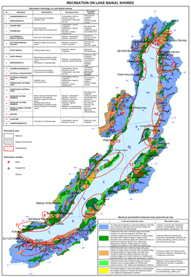
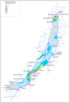
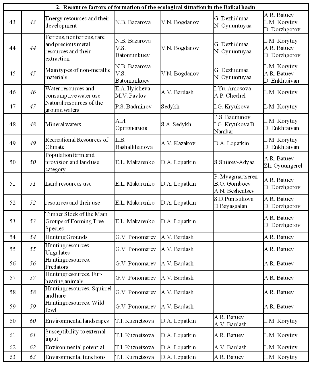
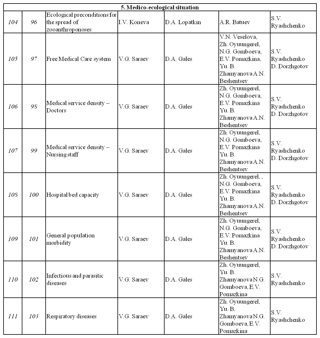
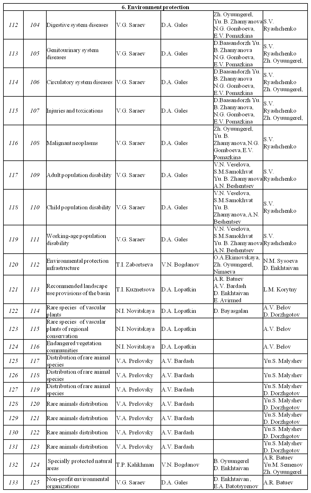
Structurally, the Atlas consists of eight blocs, including an introduction and seven thematic sections: 1) Natural conditions of the development of the environmental situation; 2) Resource factors of the development of the environmental situation; 3) Socio-economic factors of the development of the environmental situation; 4) Environmental transformation; 5) Medico-ecological situation, 6) Environmental protection; and 7) Ecological state of Lake Baikal. </i><i> </i></p>
<p class="a" style="text-align: justify; "><i>The Atlas is published in digital and hard-copy formats. A digital copy of the Atlas will be incorporated as an electronic resource with a database into the Geoportal of the Baikal Region, which is being created by the Global Environment Facility. A hard-copy of the Atlas will be released as a fundamental reference atlas.</i><i> </i></p>
<p class="a" style="text-align: justify; "><i>The Atlas is a collective work of many scientists who are experts in various fields of knowledge. The maps were created using library and published statistical materials provided not only by research institutions, but also by government authorities of the regions of the Russian Federation: Irkutsk oblast, Republic of Buryatia and Zabaikalsky krai, as well as research organizations and government authorities of Mongolia, and the authors of the Atlas are </i><i><br /> </i><i>deeply grateful for it.</i><i> </i></p>
<p class="a" style="text-align: justify; "><i> </i></p>
<p class="a" style="text-align: justify; "><i>V. M. Plyusnin, Chair of Editorial Board</i><i> </i></p>
<p align="center"> </p>
<p align="center"><span>List of Creators</span></p>
<p style="text-align: left; "><img class="image-inline" src="../../../../resolveuid/04c1f8f55c82417bb037939ae3d545be/@@images/image/preview" /></p>
<p style="text-align: left; "><a href="http://bic.iwlearn.org/en/photos/1.png" class="internal-link">Open full size</a></p>
<p style="text-align: left; "><img class="image-inline" src="../../../../resolveuid/a8db3187025f414aa113f089f8348298/@@images/image/preview" /></p>
<p style="text-align: left; "><a href="http://bic.iwlearn.org/en/photos/copy_of_2.png" class="internal-link">Open full size</a></p>
<p style="text-align: left; "><img class="image-inline" src="../../../../resolveuid/8a95db494775414787e70359d25b53de/@@images/image/preview" /></p>
<p style="text-align: left; "><a href="http://bic.iwlearn.org/en/photos/copy_of_3.png" class="internal-link">Open full size</a></p>
<p style="text-align: left; "><img class="image-inline" src="../../../../resolveuid/7d20d2ffe061475286eb49d4651c4782/@@images/image/preview" /></p>
<p style="text-align: left; "><a href="http://bic.iwlearn.org/en/photos/copy_of_4.png" class="internal-link">Open full size</a></p>
<p style="text-align: left; "><img class="image-inline" src="../../../../resolveuid/1ab7fb7b8cd64ed19af7cf004284bc5f/@@images/image/preview" /></p>
<p style="text-align: left; "><a href="http://bic.iwlearn.org/en/photos/copy_of_5.png" class="internal-link">Open full size</a></p>
<p style="text-align: left; "><img class="image-inline" src="../../../../resolveuid/c2faf8c328bc4c37bf6b2e3da4908b9a/@@images/image/preview" /></p>
<p style="text-align: left; "><a href="http://bic.iwlearn.org/en/photos/copy_of_6.png" class="internal-link">Open full size</a></p>
<p style="text-align: left; "><a href="http://bic.iwlearn.org/en/photos/copy_of_6.png" class="internal-link"></a><img class="image-inline" src="../../../../resolveuid/d32432c42ca243389126e305c8d209a1/@@images/image/preview" /></p>
<p style="text-align: left; "><a href="http://bic.iwlearn.org/en/photos/copy_of_7.png" class="internal-link">Open full size</a></p>]]></content:encoded>
    <dc:publisher>No publisher</dc:publisher>
    <dc:creator>Alexander Ayurzhanaev</dc:creator>
    <dc:rights></dc:rights>
    <dc:date>2014-10-24T02:05:00Z</dc:date>
    <dc:type>Page</dc:type>
  </item>


  <item rdf:about="http://bic.iwlearn.org/en/atlas/atlas/about-the-project">
    <title>About the project</title>
    <link>http://bic.iwlearn.org/en/atlas/atlas/about-the-project</link>
    <description></description>
    
    <dc:publisher>No publisher</dc:publisher>
    <dc:creator>Alexander Ayurzhanaev</dc:creator>
    <dc:rights></dc:rights>
    <dc:date>2014-10-22T06:47:24Z</dc:date>
    <dc:type>Folder</dc:type>
  </item>


  <item rdf:about="http://bic.iwlearn.org/ru/atlas/atlas/copy_of_o-proekte">
    <title>О проекте</title>
    <link>http://bic.iwlearn.org/ru/atlas/atlas/copy_of_o-proekte</link>
    <description></description>
    
    <dc:publisher>No publisher</dc:publisher>
    <dc:creator>Alexander Ayurzhanaev</dc:creator>
    <dc:rights></dc:rights>
    <dc:date>2014-10-22T06:40:00Z</dc:date>
    <dc:type>Folder</dc:type>
  </item>


  <item rdf:about="http://bic.iwlearn.org/en/atlas/atlas/142-aesthetic-image-of-the-baikal-shore-map/aesthetic-image-of-the-baikal-shore-map">
    <title>Aesthetic image of the Baikal shore map</title>
    <link>http://bic.iwlearn.org/en/atlas/atlas/142-aesthetic-image-of-the-baikal-shore-map/aesthetic-image-of-the-baikal-shore-map</link>
    <description></description>
    <content:encoded xmlns:content="http://purl.org/rss/1.0/modules/content/"><![CDATA[<p><img class="image-inline" src="../../../../resolveuid/3b706d3bc9bc4e7092fe3dbd6318a455/@@images/image/preview" /></p>
<p><a href="http://bic.iwlearn.org/en/photos/copy2_of__142_AESTHETICIMAGEOFTHEBAIKALSHORE.png" class="internal-link">Open full size</a></p>
<p class="a" style="text-align: center; "><b>The Aesthetic Image of the Baikal Coastal Area</b></p>
<p class="a">Riviera - an aesthetically holistic coastal territory, where, provided that the specifics of visual perception are duly considered, the integrity, beauty, and picturesqueness of spatial processes of interaction between settlements and the coast is reflected through the development of cultural recreation landscapes.</p>
<p class="a">The map of the coastal organization is created as a result of the landscape and architectural assessment that evaluated not only functional and utilitarian requirements reflecting current transportation, communication, and settlement situations, but also aesthetic, architectural, and artistic (scenic) qualities of landscapes and conditions of their development within the belt of the best visual perception.</p>
<p>Structurally, this map represents a system of landscape and architectural centers, axes, zones, and basins. Two zones are identified in the belt of visual perception (approx. 8 km wide): the zone of the best visual perception and the zone for developing visual perception (inset) that include the main types of natural landscapes assessed by their aesthetic value. Segments of the Baikal coastal area are considered as the landscape and architectural basins. Visually, they are relatively homogeneous and located within the open or closed angles of view from recreation centers and settlements and from some segments of highways.</p>]]></content:encoded>
    <dc:publisher>No publisher</dc:publisher>
    <dc:creator>Alexander Ayurzhanaev</dc:creator>
    <dc:rights></dc:rights>
    <dc:date>2014-10-15T08:05:00Z</dc:date>
    <dc:type>Page</dc:type>
  </item>


  <item rdf:about="http://bic.iwlearn.org/en/atlas/atlas/142-aesthetic-image-of-the-baikal-shore-map">
    <title>142. Aesthetic image of the Baikal shore map</title>
    <link>http://bic.iwlearn.org/en/atlas/atlas/142-aesthetic-image-of-the-baikal-shore-map</link>
    <description></description>
    
    <dc:publisher>No publisher</dc:publisher>
    <dc:creator>Alexander Ayurzhanaev</dc:creator>
    <dc:rights></dc:rights>
    <dc:date>2014-10-15T08:02:48Z</dc:date>
    <dc:type>Folder</dc:type>
  </item>


  <item rdf:about="http://bic.iwlearn.org/en/atlas/atlas/141-natural-managment-and-environmental-condition-of-central-ecological-zone-map/natural-managment-and-environmental-condition-of-central-ecological-zone-map">
    <title>Natural managment and environmental condition of central ecological zone map</title>
    <link>http://bic.iwlearn.org/en/atlas/atlas/141-natural-managment-and-environmental-condition-of-central-ecological-zone-map/natural-managment-and-environmental-condition-of-central-ecological-zone-map</link>
    <description></description>
    <content:encoded xmlns:content="http://purl.org/rss/1.0/modules/content/"><![CDATA[<p><img class="image-inline" src="../../../../resolveuid/21728bd36dac488cb470339c94e9a1b1/@@images/image/preview" /></p>
<p><a href="http://bic.iwlearn.org/en/photos/copy_of__141_NaturalmanagmentandenvironmentalconditionofCEZ.png" class="internal-link">Open full size</a></p>
<p align="center"><strong>Ecological state of the Central Ecological Zone of the Baikal Natural Territory</strong></p>
<p>The Central Ecological Zone of the Baikal Natural Territory (CEZ BNT) includes Lake Baikal itself with its islands, the adjacent water protection zone, and specially protected natural areas (SPNA) (Federal Law No. 94-FZ “On Protection of Lake Baikal” dated May 1, 1999). Its boundaries coincide with the boundary of the World Natural Heritage site “Lake Baikal” and follow the outer boundaries of the Baikal-Lena, Barguzinsky, and Baikalsky reserves (zapovedniks), Pribaikalsky, Zabaikalsky, and Tunkinsky national parks, Frolikhinsky, Pribaikalsky, Enkhaluksky, and Snezhinsky nature-sanctuaries (zakazniks), as well as the main watersheds of the Primorsky, Baikalsky, Verkhne-Angarsky, Barguzinsky, Golondinsky, Ulan-Burgasy, Morskoy, and Khamar-Daban ridges. The main function of the central ecological zone is to preserve the unique ecological system of Lake Baikal and to prevent the negative impact of economic and other activity on its state.</p>
<p class="BodyTextIndent2">The main sources of the atmospheric impact on Lake Baikal are industrial enterprises located in the basin and on the shores of the lake, and sections of the Trans-Siberian Railway and Baikal-Amur Mainline. Air emissions from industrial enterprises and boiler stations of the towns of Baikalsk, Slyudyanka, Severobaikalsk, and Nizhneangarsk and villages located in the Baikal basin have the highest probability of falling into the lake. Air transport products from the Irkutsk-Cheremkhovo agglomeration constitute a much smaller part of the total air pollution over Lake Baikal because of the remoteness and a large number of calms and fogs. Emissions of sulfur dioxide, nitrogen oxides, hydrogen sulphide and hydrocarbon, methyl mercaptan, formaldehyde, and phenol, produced by coastal enterprises have a negative impact on the ecological situation.</p>
<p>On the northern shore of Lake Baikal a single zone of the atmospheric pollution distribution, stretched along Lake Baikal, is formed. Its area for the town of Severobaikalsk amounts to approximately 150 km, and for Nizhneangarsk – to 60 km. Despite the fact that the content of certain impurities tends to decrease, the level of air pollution remains high.</p>
<p>The snow cover, having a high sorption capacity, is the most informative object in identifying the technogenic pollution of the atmosphere. According to the data of the Irkutsk Territorial Administration for Hydrometeorology and Environmental Monitoring, in the CEZ BNT there are several zones of technogenic pollution with the solids concentration in snow ranging from 0.5 to 10 g/kg. Mineralization of snow waters near the sources may exceed the background one by 10 times. The maximum amount of solids in snow reaches 200 g/m<sup>2</sup>. Zones with increased concentration of calcium, magnesium, sodium, and potassium were identified. Concerning the cations, which are soluble in snow, the predominance of sodium and potassium was revealed. The maximum values ​​of the insoluble residue of snow associated with the operation of CHP plants, boiler stations, and stove heating, are registered in the vicinity of Kultuk and Sludyanka; as regards the soluble residue, its maximum values are recorded in the area around Baikalsk. The total area of snow pollution with chemical elements extends 60 km from the southeast to the northwest with a width of 10-15 km.</p>
<p>In connection with the spontaneous development of tourism on the shores of Lake Baikal in the CEZ BNT, one of the most pressing issues is the problem of collecting, processing, and recycling of solid household wastes. Most of the garbage goes to disposal sites, both approved and unauthorized.</p>
<p>Within the CEZ BNT, cement and quartz raw materials, facing and ornamental stones, and different kinds of building materials are produced with local environmental disturbances. Significant anthropogenic changes of the natural environment (felled and burnt areas, etc.) are also observed near settlements, roads, and tourist centers and camps.</p>
<p>In order to establish a long-term strategy for the organization of the use of the CEZ BNT, which would ensure a sustainable development and preservation of the unique ecological system of Lake Baikal through reducing the anthropogenic impact and preventing the damage, a technique and scheme of territorial planning of the CEZ BNT was developed [Plyusnin and Vladimirov, 2013].<b> </b></p>
<p align="center"><b> </b></p>
<p align="center">References</p>
<p>Plyusnin, V. M., Vladimirov, I. N. (2013). <i>Territorial planning of the Central Ecological Zone of the Baikal Natural Territory</i>. Novosibirsk: Geo. p 407.</p>]]></content:encoded>
    <dc:publisher>No publisher</dc:publisher>
    <dc:creator>Alexander Ayurzhanaev</dc:creator>
    <dc:rights></dc:rights>
    <dc:date>2014-10-15T08:00:00Z</dc:date>
    <dc:type>Page</dc:type>
  </item>


  <item rdf:about="http://bic.iwlearn.org/en/atlas/atlas/141-natural-managment-and-environmental-condition-of-central-ecological-zone-map">
    <title>141. Natural managment and environmental condition of central ecological zone map</title>
    <link>http://bic.iwlearn.org/en/atlas/atlas/141-natural-managment-and-environmental-condition-of-central-ecological-zone-map</link>
    <description></description>
    
    <dc:publisher>No publisher</dc:publisher>
    <dc:creator>Alexander Ayurzhanaev</dc:creator>
    <dc:rights></dc:rights>
    <dc:date>2014-10-15T07:57:30Z</dc:date>
    <dc:type>Folder</dc:type>
  </item>


  <item rdf:about="http://bic.iwlearn.org/en/atlas/atlas/140-recreation-on-lake-baikal-shores-map/recreation-on-lake-baikal-shores-map">
    <title>Recreation on Lake Baikal shores map</title>
    <link>http://bic.iwlearn.org/en/atlas/atlas/140-recreation-on-lake-baikal-shores-map/recreation-on-lake-baikal-shores-map</link>
    <description></description>
    <content:encoded xmlns:content="http://purl.org/rss/1.0/modules/content/"><![CDATA[<p><img class="image-inline" src="../../../../resolveuid/e16a12eb95bf4995a746b50dff491e9b/@@images/image/preview" /></p>
<p><a href="http://bic.iwlearn.org/en/photos/copy_of__140_RECREATIONONLAKEBAIKALSHORES.png" class="internal-link">Open full size</a></p>
<p class="a" style="text-align: center; "><b>Recreation on Lake Baikal</b></p>
<p class="a">Recreation as an essential type of human activity is mapped as an integral phenomenon. The degree of territorial development of recreational activities is reflected through the use of zoning (natural and natural-social recreation zones). The zones' borders correspond to the isohypse of 1500 m. The contours are defined by a natural and landscape differentiation. Five levels of maximum permissible density (people/ha/day) have been identified.</p>
<p class="a">The main point in the explanatory note is the district and settlement zoning of recreation territories (the main and supplemental recreation centers) with due consideration to the typology of destinations and their specialization by forms and types of recreational activities.  <i></i></p>
<p class="a"><i>Assessment of the coastal landscapes for recreational activities.</i></p>
<p class="a">Natural landscapes untouched by human activity directly and comprehensively satisfy the requirements of the physiologically needed recreation (unconscious-reflectory), such as contemplation, solace, relaxation, and so on.  These landscapes (groups of landscapes) must be protected. The most accessible part of the Baikal coast demonstrates a certain degree of environmental transformation. Social and specific (purposeful and deliberate) forms of recreation dominate recreation activities on these territories. The accumulation of the problems connected to the anthropogenic impact leads to the digression of landscapes and even to the loss of landscape diversity and total uselessness of the territory in terms of meeting the needs of recreation.</p>
<p>The map shows the types and subtypes of natural landscapes within the Central Ecological Zone of Lake Baikal. It also shows the zones of natural resources management, where integrated targets of the landscape and territorial planning should be achieved (preservation, improvement, development), and the territories that should be protected and recultivated</p>]]></content:encoded>
    <dc:publisher>No publisher</dc:publisher>
    <dc:creator>Alexander Ayurzhanaev</dc:creator>
    <dc:rights></dc:rights>
    <dc:date>2014-10-15T07:55:00Z</dc:date>
    <dc:type>Page</dc:type>
  </item>


  <item rdf:about="http://bic.iwlearn.org/en/atlas/atlas/140-recreation-on-lake-baikal-shores-map">
    <title>140. Recreation on Lake Baikal shores map</title>
    <link>http://bic.iwlearn.org/en/atlas/atlas/140-recreation-on-lake-baikal-shores-map</link>
    <description></description>
    
    <dc:publisher>No publisher</dc:publisher>
    <dc:creator>Alexander Ayurzhanaev</dc:creator>
    <dc:rights></dc:rights>
    <dc:date>2014-10-15T07:44:34Z</dc:date>
    <dc:type>Folder</dc:type>
  </item>


  <item rdf:about="http://bic.iwlearn.org/en/atlas/atlas/139-distribution-omul-map/distribution-omul-map">
    <title>Distribution omul map</title>
    <link>http://bic.iwlearn.org/en/atlas/atlas/139-distribution-omul-map/distribution-omul-map</link>
    <description></description>
    <content:encoded xmlns:content="http://purl.org/rss/1.0/modules/content/"><![CDATA[<p><img class="image-inline" src="../../../../resolveuid/d21a970aef1f4c1e8a53d18ce0a39d10/@@images/image/preview" /></p>
<p><a href="http://bic.iwlearn.org/en/photos/copy_of__139_Distributionomul.png" class="internal-link">Open full size</a></p>
<p class="a" style="text-align: center; "><b>Hydroacoustic measurement of the Baikal omul resources</b></p>
<p class="a">In 2011, the assessment of the number and biomass of the Baikal omul Coregonus migratorius was carried out using the hydroacoustic method [1].</p>
<p class="a">The results of the assessment are shown in Tables 1 and 2. The distribution of the number and biomass of the Baikal omul in the water area of Lake Baikal is uneven. Amassments with the density above average take less than a quarter of the examined area. However, they contain almost two thirds of the Baikal omul reserves. A general picture of the spatial distribution of the omul in the lake's water area corresponds with trawling and acoustic measurements. Our work confirmed the necessity of conducting such measurements immediately after ice clearance, but before the start of feeding migrations of the Baikal omul. During this period, the omul forms dense shoals that are easy to register using the hydroacoustic technique, which improves the accuracy of measurements. The derived number and biomass figures of the Baikal omul, especially in the Selenga shallow water area and Northern Baikal, correspond quite well with the forecast of the long-term dynamics based on the peculiarities of the size- and age-related composition of the fish population[2].</p>
<p class="a">We confirmed the findings about the presence of a significant part of the omul population in the deep-water zones of the lake.</p>
<p align="center" class="a">References:</p>
<p class="a">Makarov, M. M., Degtev, A. I., Kucher, K. M., Mamontov, A. M., Nebesnykh, I. A., Khanaev, I. V. &amp; Dzyuba, E. B. (2012). Assessment of the number and the biomass of the Baikal omul using trawling and acoustic techniques. <i>DAN, 447</i>(3). p 343-346.</p>
<p>Melnik, N. G., Smirnova-Zalumi, N. S., Smirnov, V. V., et al. (2009). <i>Hydroacoustic measurement of the Baikal omul resources</i>. Novosibirsk: Nauka. p 244.</p>
<p><img class="image-inline" src="../../../../resolveuid/9046812ec12c496393f9107a426d3f2a/@@images/image/preview" /></p>
<p><a href="http://bic.iwlearn.org/en/photos/139.jpg" class="internal-link">Open full size</a></p>]]></content:encoded>
    <dc:publisher>No publisher</dc:publisher>
    <dc:creator>Alexander Ayurzhanaev</dc:creator>
    <dc:rights></dc:rights>
    <dc:date>2014-10-15T05:10:00Z</dc:date>
    <dc:type>Page</dc:type>
  </item>


  <item rdf:about="http://bic.iwlearn.org/en/atlas/atlas/139-distribution-omul-map">
    <title>139. Distribution omul map</title>
    <link>http://bic.iwlearn.org/en/atlas/atlas/139-distribution-omul-map</link>
    <description></description>
    
    <dc:publisher>No publisher</dc:publisher>
    <dc:creator>Alexander Ayurzhanaev</dc:creator>
    <dc:rights></dc:rights>
    <dc:date>2014-10-15T04:51:24Z</dc:date>
    <dc:type>Folder</dc:type>
  </item>


  <item rdf:about="http://bic.iwlearn.org/en/atlas/atlas/138-bubble-the-gas-outlet-from-the-bottom-sediments-map/bubble-the-gas-outlet-from-the-bottom-sediments-map">
    <title>Bubble the gas outlet from the bottom sediments map</title>
    <link>http://bic.iwlearn.org/en/atlas/atlas/138-bubble-the-gas-outlet-from-the-bottom-sediments-map/bubble-the-gas-outlet-from-the-bottom-sediments-map</link>
    <description></description>
    <content:encoded xmlns:content="http://purl.org/rss/1.0/modules/content/"><![CDATA[<p><img class="image-inline" src="../../../../resolveuid/3db0cde9a6354efc8c79148fc3798900/@@images/image/preview" /></p>
<p><a href="http://bic.iwlearn.org/en/photos/138_Bubblethegasoutletfromthebottomsediments_Fixed.png" class="internal-link">Open full size</a></p>
<p align="center"><b>Gas bubble emissions from bottom sediments of Lake Baikal</b></p>
<p align="center"><b> </b></p>
<p>Methane emissions from bottom sediments in Lake Baikal have been known for a long time. Even the first travelers, who visited the lake in the 17<sup>th</sup> century, noticed gas emissions. Later gas emissions in Baikal were explored by the East Siberian Branch of the Russian Imperial Geographical Society. A review of the available materials on gas seeps in Baikal is presented in the publication [Granin and Granina, 2002]. A new stage of research on gas seeps in Baikal started after the discovery of gas hydrates [Kuzmin et al., 1998] and mud volcanoes at the bottom of the lake [Van Rensbergen et al., 2002] at the turn of the 20<sup>th</sup> century.</p>
<p>Gas seeps are found in oceans, seas and freshwater bodies. To study gas seeps hydroacoustic methods are used, as they enable an extensive search due to the strong backscattering of sound from the bubbles of floating-up gas. To locate and monitor the activity of gas plumes a digital record of acoustic signals of the echo sounders FURUNO, installed on the research vessels “G. Yu. Vereshchagin”, “Titov” and “Papanin”, was organized.</p>
<p>We subdivide gas seeps into shallow- and deepwater [Granin et al., 2010]. Deepwater gas seeps (red triangles on the map) are the ones that are located at depths greater than the depth of the gas hydrate stability (380 m); gas seeps, located at shallower depths (blue circles), belong to shallow-water gas seeps.</p>
<p>A substantial proportion of the shallow gas seeps are located near the Selenga river delta and on the Posolskaya bank. Multi-year monitoring of the activity of gas seeps made it possible to identify long-term and periodic gas shows. A maximum flare height of more than 1000 m was recorded in the area of ​​the mud volcano Malenky on June 23, 2011 from the RV “Titov”. According to the echo sounders data, the rise rates of gas bubbles reach 25 cm/s or more. In the area of plumes there is a near-bottom layer, where the temperature gradient is equal to the adiabatic one. This is indicative of a complete mixing of a significant layer of water as a result of the gas emissions [Granin et al.]</p>
<p>Using the acoustic sounding, a gas flow from bottom sediments was estimated. The estimation of the flow was made for several deepwater plumes. For different plumes the methane flow from the bottom sediments of Lake Baikal ranged from 14 to 216 tons per year. Comparing the result obtained with corresponding estimates for other water bodies, it may be said that the gas flow for the largest bottom gas seeps in Lake Baikal is corresponding to the flows in the Norwegian Sea and the Sea of ​​Okhotsk [Granin et al., 2-12].<b> </b></p>
<p align="center"><b> </b></p>
<p align="center">References</p>
<p>Granin, N. G., Granina, L. Z. (2002). Gas hydrates and gas venting in Lake Baikal. <i>Russ. Geol. Geophys, 43</i>(7), p 629-637.</p>
<p>Kuzmin, M. I., Kalmychkov, G. V., &amp; Gelety, V. F. (1998). The first finding of gas hydrates in the sedimentation mass of Lake Baikal. <i>Proceedings of the Russian Academy of Sciences, 362</i>(4). p 541-543.</p>
<p>Van Rensbergen, P., De Batist M., Klerkx J., Hus R., Poort J., Vanneste M., Granin N., Khlystov O., &amp; Krinitsky P. (2002). Sublacustrine mud volcanoes and methane seeps caused by dissociation of gas hydrates in Lake Baikal. <i>Geology, 30</i>(7). p 631-634.</p>
<p>Granin, N. G., Makarov, M. M., Kucher, K. M., &amp; Gnatovsky, R. Y. (2010). Gas seeps in Lake Baikal: Detection, distribution, and implications for water column mixing. <i>Geo-Marine Letters, 30</i>(3-4). p 399-409.</p>
<p>Granin N. G., Muyakshin, S. I., Makarov, M. M., Kucher, K. M., Aslamov, I. A., Granina, L. Z., &amp; Mizandrontsev, I. B. (2012). Estimation of methane flows from bottom sediments of Lake Baikal. <i>Geo-Marine Letters, 32</i>(5-6). p 427-436. DOI 10.1007/s00367-012-0299-6</p>]]></content:encoded>
    <dc:publisher>No publisher</dc:publisher>
    <dc:creator>Alexander Ayurzhanaev</dc:creator>
    <dc:rights></dc:rights>
    <dc:date>2014-10-15T04:50:00Z</dc:date>
    <dc:type>Page</dc:type>
  </item>


  <item rdf:about="http://bic.iwlearn.org/en/atlas/atlas/138-bubble-the-gas-outlet-from-the-bottom-sediments-map">
    <title>138. Bubble the gas outlet from the bottom sediments map</title>
    <link>http://bic.iwlearn.org/en/atlas/atlas/138-bubble-the-gas-outlet-from-the-bottom-sediments-map</link>
    <description></description>
    
    <dc:publisher>No publisher</dc:publisher>
    <dc:creator>Alexander Ayurzhanaev</dc:creator>
    <dc:rights></dc:rights>
    <dc:date>2014-10-15T04:41:35Z</dc:date>
    <dc:type>Folder</dc:type>
  </item>


  <item rdf:about="http://bic.iwlearn.org/en/atlas/atlas/137-uninodal-binodal-trinodal-and-quadrinodal-seic_65-map/uninodal-binodal-trinodal-and-quadrinodal-seic_65-map">
    <title>Uninodal, binodal, trinodal, and quadrinodal seic_65 map</title>
    <link>http://bic.iwlearn.org/en/atlas/atlas/137-uninodal-binodal-trinodal-and-quadrinodal-seic_65-map/uninodal-binodal-trinodal-and-quadrinodal-seic_65-map</link>
    <description></description>
    <content:encoded xmlns:content="http://purl.org/rss/1.0/modules/content/"><![CDATA[<p><img class="image-inline" src="../../../../resolveuid/dd71b06dd46b4563ac843e1369873859/@@images/image/preview" /></p>
<p><a href="http://bic.iwlearn.org/en/photos/copy_of__137_UNINODALBINODALTRINODALANDQUADRINODALSEIC_65.png" class="internal-link">Open full size</a></p>
<p align="center" class="a"><b>Uninodal (bimodal, trinodal and quadrinodal) </b></p>
<p align="center" class="a"><b>seiche oscillations </b></p>
<p class="a" style="text-align: left; "><b></b><span>Seiches are standing waves in an enclosed or partially enclosed water body. Seiche oscillations in Lake Baikal are observed almost continuously throughout the whole year. Some characteristics of these oscillations were obtained from in-situ observations, laboratory experiments on a spatial hydraulic model and from appropriate theoretical calculations. The results of these studies have been published in the works (References). However, available information on Baikal seiches is scarce due to the difficulties of in-situ measurements and rather crude data on bottom topography. Sophisticated instrumental tools and advanced techniques for in-situ measurements were used to perform calculations of seiche oscillations in Lake Baikal based on a spectral difference model using specified bathymetric data obtained by researchers from Limnological Institute SB RAS. All these data are included in this atlas. The main aim of this study was to investigate solutions corresponding to oscillations with the periods of 277, 152, 84, 67, and 59 min, which were identified during in-situ observations.</span></p>
<p class="a">The spectral difference model is based on the linearized system of equations for shallow water in the spherical coordinate system. Difference approximation is based on irregular triangular spatial mesh. The side length of the calculation mesh is 30 m near the shoreline and about 1 km for the rest of the model area. The numerical model includes solution of the eigenvalues problem. It allows the researchers to get a set of frequencies and corresponding forms of seiche oscillations.</p>
<p class="a">The calculations were obtained taking into consideration the Earth’s rotation. Complex solutions were normalised in such a way that imaginary component was minimal, whereas true components of solutions for the rest of the model area were within the range of -10 to 10. The values in the nodes with the depth less than 10 m and in the nodes within the contour of Maloye More (Small Sea) were not taken into account. Spatial distribution of seiche oscillations with the periods of 276.96; 151.58; 84.25; and 67.38 min corresponds to uninodal, binodal, trinodal, and quadrinodal longitudinal seiche modes of Lake Baikal. The level distribution along the centreline is shown for the enumerated modes in Figure. It should be noted that it is necessary to use other approaches for specification of solutions in shallow areas of Lake Baikal, such as Mukhor and Proval Bays and Cherkalovsky and Posolsk Sors, where the bottom friction is likely to play a significant role. The results for the first mode are consistent with the data on distribution of seiche oscillation height along the Baikal length in [Sudolsky, 1991, Fig. 5.2], in which the data on calculations and survey results from the spatial hydraulic model are compared.</p>
<p>Amplitudes of seiche oscillations in Lake Baikal and their seasonal variability were analysed from the data obtained at 3 stations located in the southern basin of the lake. Well-defined maxima for the oscillations with the periods of 277, 152, 84, and 67 min are observed within the range of density spectrum derived from the annual level record. No significant differences were recorded between the amplitudes for a uninodal seiche and amplitudes during the rest of the year when the lake is covered with ice and protected from wind. It was established that a seiche with the period of 67 min is observed in different seasons of the year. At three stations, level changes for the oscillation with the 277 min period differ in significantly. For the 152 min period they have slight differences, and for the 84 and 67 min periods they are similar only at those sites with relatively high amplitudes of oscillations. This is attributed to the effect of wind and atmospheric pressure. Measured and calculated periods for the first four seiche modes are given in Table.</p>
<p style="text-align: center; "><img class="image-inline" src="../../../../resolveuid/e9e95945b27643c6b6ebba950fc140a9/@@images/image/preview" /></p>
<p align="center" class="a">References</p>
<p class="a">Arsenyeva, N. M., Davydov, L. K., Dubrovina, L. N., &amp; Konkina, N. G. (1963). <i>Seiches in lakes of the USSR</i>. Leningrad: LSU Publishing. p 184.</p>
<p class="a">Verbolov, V. I. (1970). On Baikal seiches. In <i>Seiches in lakes: Surface and internal</i>. Leningrad: Nauka. p 50-52.</p>
<p class="a">Solovyev, V. N. (1925). Method of models and its application in seiche survey at Lake Baikal. <i>News of the Institute of Biology and Geography, 2</i>. p 9-26.</p>
<p class="a">Solovyev, V. N., Shostakovich, V. B. (1926). Seiches in Lake Baikal. <i>Proceedings of Magnetic and Meteorological Observatory, 1</i>.</p>
<p class="a">Sudolsky, A. S. (1991). <i>Dynamic phenomena in water bodies</i>. Leningrad: Hydrometeoizdat. p 263 p.</p>
<p class="a">Sudolsky, A. S. (1968) Laboratory experiments and calculations of Baikal seiches. <i>Proceedings of GGI, 155</i>. p 109-123.</p>
<p class="a">Timofeev, V. Y., Ardyukov, D. G., Granin, N. G., Zhdanov, A. A., Kucher, K. M., Boiko, E. V., &amp; Timofeev, A.V.  (2010). Deformation of ice cover, tidal and true level fluctuations of Lake Baikal. <i>Phys. Mesomech: Special Issue, 13</i>, p 58-71.</p>
<p>Timofeev, V. Y., Granin, N. G., Ardyukov, D. G., Zhdanov, A. A., Kucher, K. M., &amp; Ducarme, B. (2009). Tidal and seiche signals on Baikal Lake level. <i>Bulletin of Inf. MareesTerrestres</i>, 145. p 11635—11658.</p>]]></content:encoded>
    <dc:publisher>No publisher</dc:publisher>
    <dc:creator>Alexander Ayurzhanaev</dc:creator>
    <dc:rights></dc:rights>
    <dc:date>2014-10-15T03:20:00Z</dc:date>
    <dc:type>Page</dc:type>
  </item>


  <item rdf:about="http://bic.iwlearn.org/en/atlas/atlas/137-uninodal-binodal-trinodal-and-quadrinodal-seic_65-map">
    <title>137. Uninodal, binodal, trinodal, and quadrinodal seic_65 map</title>
    <link>http://bic.iwlearn.org/en/atlas/atlas/137-uninodal-binodal-trinodal-and-quadrinodal-seic_65-map</link>
    <description></description>
    
    <dc:publisher>No publisher</dc:publisher>
    <dc:creator>Alexander Ayurzhanaev</dc:creator>
    <dc:rights></dc:rights>
    <dc:date>2014-10-15T03:11:30Z</dc:date>
    <dc:type>Folder</dc:type>
  </item>


</rdf:RDF>
