<?xml version="1.0" encoding="utf-8" ?>
<rdf:RDF xmlns:rdf="http://www.w3.org/1999/02/22-rdf-syntax-ns#" xmlns:dc="http://purl.org/dc/elements/1.1/" xmlns:syn="http://purl.org/rss/1.0/modules/syndication/" xmlns="http://purl.org/rss/1.0/">


<channel rdf:about="http://bic.iwlearn.org/search_rss">
  <title>Байкальский информационный центр</title>
  <link>http://bic.iwlearn.org</link>

  <description>
    
            These are the search results for the query, showing results 26 to 40.
        
  </description>


  <image rdf:resource="http://bic.iwlearn.org/logo.png"/>

  <items>
    <rdf:Seq>
      
        <rdf:li rdf:resource="http://bic.iwlearn.org/en/atlas/atlas/83-trends-in-air-temperature-map/trends-in-air-temperature-map"/>
      
      
        <rdf:li rdf:resource="http://bic.iwlearn.org/en/atlas/atlas/68-transport-infrastructure-map/transport-infrastructure"/>
      
      
        <rdf:li rdf:resource="http://bic.iwlearn.org/en/news/the-baikal-project/249e773dbad02282ba84b3d26a329ddf"/>
      
      
        <rdf:li rdf:resource="http://bic.iwlearn.org/en/news/the-baikal-project/9b3e0c3676ae6b2df051ae6aef2412b4"/>
      
      
        <rdf:li rdf:resource="http://bic.iwlearn.org/en/atlas/atlas/82-tourism-map/tourism-map"/>
      
      
        <rdf:li rdf:resource="http://bic.iwlearn.org/en/atlas/topographic-base-of-lake-baikal-coast-1-100-000"/>
      
      
        <rdf:li rdf:resource="http://bic.iwlearn.org/en/documents/documents/proceedings/2013/TOM%202_Environment%20and%20sustainable%20development%20in%20Mongolian%20plateau%20and%20surrounding%20regions%20-rus.pdf"/>
      
      
        <rdf:li rdf:resource="http://bic.iwlearn.org/en/documents/documents/proceedings/2013/TOM%201_Environment%20and%20sustainable%20development%20in%20Mongolian%20plateau%20and%20surrounding%20regions%20-rus.pdf"/>
      
      
        <rdf:li rdf:resource="http://bic.iwlearn.org/en/atlas/atlas/53-timber-stock-of-the-main-groups-of-forest-forming-tree-species-map/timber-stock-of-the-main-groups-of-forest-forming-tree-species-map"/>
      
      
        <rdf:li rdf:resource="http://bic.iwlearn.org/en/documents/documents/papers/the-water-situation-in-ulaanbaatar"/>
      
      
        <rdf:li rdf:resource="http://bic.iwlearn.org/en/atlas/atlas/89-the-quality-of-surface-water-map/the-quality-of-surface-water-map"/>
      
      
        <rdf:li rdf:resource="http://bic.iwlearn.org/en/friends/the-nature-conservancy-in-mongolia-mongolia"/>
      
      
        <rdf:li rdf:resource="http://bic.iwlearn.org/en/monitoring/the-harmonized-water-quality-monitoring-program-in-the-selenga-river-basin"/>
      
      
        <rdf:li rdf:resource="http://bic.iwlearn.org/en/documents-1/the-harmonized-water-quality-monitoring-program-in-the-selenga-river-basin"/>
      
      
        <rdf:li rdf:resource="http://bic.iwlearn.org/en/atlas/atlas/93-the-disturbance-of-vegetation-in-the-lake-baikal-basin-map/the-disturbance-of-vegetation-in-the-lake-baikal-basin-map"/>
      
    </rdf:Seq>
  </items>

</channel>


  <item rdf:about="http://bic.iwlearn.org/en/atlas/atlas/83-trends-in-air-temperature-map/trends-in-air-temperature-map">
    <title>Trends in air  temperature map</title>
    <link>http://bic.iwlearn.org/en/atlas/atlas/83-trends-in-air-temperature-map/trends-in-air-temperature-map</link>
    <description></description>
    <content:encoded xmlns:content="http://purl.org/rss/1.0/modules/content/"><![CDATA[<p><img class="image-inline" src="../../../resolveuid/b99a980033dc4346966565e525d63d9e/@@images/image/preview" /></p>
<p><a href="http://bic.iwlearn.org/en/atlas/photos/copy_of__83_TRENDSINAIRTEMPERATURE.png" class="internal-link">Open full size</a></p>
<p align="center"><strong>C</strong><strong>limate change</strong></p>
<p align="center"><strong> </strong></p>
<p>The ratio of a linear trend, which is determined by the least square technique and characterizes the average rate of the climatic variable corresponding to the trend, was used as a measure of intensity of climatic changes within a specified period of time.</p>
<p>Annual temperature of the lower layer of air is used to describe the current climatic changes. The physical sense of this climatic characteristic is determined by an almost linear dependence of longwave radiation coming from the top border of the atmosphere on the temperature of the lower air layer. Given this dependence, the assessment of the indicated temperature is largely analogous to the estimation of the average outgoing longwave radiation, which can be used to determine the speed of heating or cooling of the Earth's surface.</p>
<p>Annual temperature trend values in 1961-2008 were positive and ranged from 0.24° to 0.52° C/10 years, which is an order of magnitude higher than similar ratios calculated on the average for the Northern Hemisphere. Maximum values of the trend are observed in the north of the study area. One of the centers is located in the Barguzinsky reserve. This area (on the northeastern coast of Lake Baikal) is also interesting, as unlike other weather stations it has the same high trends throughout the year. The majority of these locations is characterized by the annual variation of the coefficients describing the linear trend of air temperature, with a peak in February and a minimum in the summer months. July has an asymmetric distribution of trend values. Although they are all statistically significant, their maximum clearly shifts to the territory of Zabaikalsky krai. The foothills of the Khamar-Daban (the Khamar-Daban station) and the upper Lena river (the Kachug station) can be called the local areas of minimal trends during all months of the year.</p>
<p> </p>
<p>A quite different pattern is observed for the trends in annual precipitation. Positive trends take place approximately on the two thirds of the basin, where there are two places with maximum values exceeding 10-15 mm/10 years – in the basins of the rivers Khilok and Chikoy and in the town of Babushkin and its adjacent mountainous area. On the other hand, negative trends in precipitation with the gradient of -15 mm/ 10 years are observed in the most part of the Khamar-Daban mountain range, southern Buryatia, the Olkhon area, the coastal area of Barguzinsky Bay, and some other territories.</p>]]></content:encoded>
    <dc:publisher>No publisher</dc:publisher>
    <dc:creator>Alexander Ayurzhanaev</dc:creator>
    <dc:rights></dc:rights>
    <dc:date>2014-10-10T01:45:00Z</dc:date>
    <dc:type>Page</dc:type>
  </item>


  <item rdf:about="http://bic.iwlearn.org/en/atlas/atlas/68-transport-infrastructure-map/transport-infrastructure">
    <title>Transport infrastructure map</title>
    <link>http://bic.iwlearn.org/en/atlas/atlas/68-transport-infrastructure-map/transport-infrastructure</link>
    <description></description>
    <content:encoded xmlns:content="http://purl.org/rss/1.0/modules/content/"><![CDATA[<p><img class="image-inline" src="../../../resolveuid/7e13088354044c09957e8a77de60b76d/@@images/image/preview" /></p>
<p><a href="http://bic.iwlearn.org/en/atlas/photos/copy_of__68_Transportinfrastructure.png" class="internal-link">Open full size</a></p>
<p align="center"><strong>Transport</strong></p>
<p align="center"><strong> </strong></p>
<p>Transportation infrastructure of the Baikal basin is a constituent part of the transportation systems of Irkutsk oblast, Republic of Buryatia, Zabaikalsky krai, and Mongolia. This territory has almost all modes of transportation, namely, railways, roads, shipping, and air transportation. The cities of Irkutsk and Chita located outside the Baikal basin are also considered, as they are important logistics hubs of the Baikal basin. <strong> </strong></p>
<p>Railways in the Russian part of the basin are part of the East Siberian Railway. Railway serves the Southern and Northern Baikal region. The Baikal-Amur Mainline runs along the northern shore of Lake Baikal and along the valley of the Upper Angara river. A short segment of the Trans-Siberian Railway runs along the southern shore of Lake Baikal and further to the east. In the Baikal basin, it forks into two railways – the Circum-Baikal Railway (84 km) and the Ulan-Ude – Naushki Railway (253 km), which runs all the way to Mongolia, where it connects to the Ulaanbaatar Railway. In Mongolia, the major railway is the one running from the Russian border through Ulaanbaatar to the border with China and further to Beijing. In the Baikal basin, this railway has branches to Erdenet, Sharyn Gol, and Baganuur.</p>
<p class="a">The effect of the railway transportation on the environment includes the impact on the atmosphere in the districts, where diesel locomotives are used. Transportation of explosives, chemicals, and other hazardous cargo is also potentially dangerous.</p>
<p class="a">The most important motorway is the federal highway Irkutsk – Ulan-Ude – Chita (a segment of the Moscow Highway), which runs parallel to the Trans-Siberian Railway. Besides this highway, the segments of the motorways Kultuk – Mondy, Irkutsk – Listvyanka, Magistralny – Severobaikalsk – Uoyan – Taksimo, Taksimo – Bodaibo, Bayanday – Elantsy – Khuzhir, Ulan-Ude – Turuntaevo – Kurumkan, Ulan-Ude – Kyakhta with a branch to Zakamensk, Ulan-Ude – Bichura, Ulan-Ude – Sosnovo-Ozerskoe – Bagdarin, Chita – Bagdarin, Chita – Aginskoe, etc. also run across this territory. In Mongolia, a hard surface highway runs from the Russian border to Ulaanbaatar and further to the border with China. There is a branch of this highway connecting Darkhan, Erdenet, and Bulgan. There are two more paved motorways running from Ulaanbaatar to Tsetserleg and Underhaan. The rest of Mongolian motorways are dirt roads. The main motorways shown on the map are federal highways in Russia and major inter-aimag roads in Mongolia.</p>
<p class="a">Motor vehicles are the most intensive source of environmental pollution. On average, one vehicle consumes about four tons of oxygen from the atmosphere annually and emits about 800 kg of carbon oxide, 40 kg of nitrogen oxide, and almost 200 kg of different carbons [1]. This pollution is more pronounced in settlements. Thus, in Ulan-Ude it makes 58% of the total pollutant emission, in Chita – 72%. The increased pollution in larger cities is associated with a more intensive use of auto transportation and high rates of car ownership among the general population. Moreover, noise from motor vehicles also negatively impacts people’s health in the cities. The impact of motor vehicles on the environment outside of settlements occurs along highways. The concentration of heavy metals along the highways increases 10 to 20 times as compared to the background level. Another factor of the impact of motor vehicles is the dust formation in the air near the ground especially on dirt and gravel roads. Off-road driving in Mongolian steppes and on the shores of Lake Baikal is also a problem, as it damages vegetation of local landscapes.</p>
<p class="a">Motor vehicle pollution in the Baikal basin is the major type of the impact of transportation on the environment and, especially, on human health.</p>
<p>Ship traffic in this territory takes place on Lake Baikal and Lake Khovsgol, as well as on the Angara and Selenga rivers. The fleet used on Lake Baikal in 2012 and registered by the East-Siberian Branch of the Russian River Register includes: 1) general service and recreational boats and search and rescue vessels; 2) dry cargo, passenger, expedition, and research vessels; 3) freight and passenger-and-freight ferries; 4) self-propelled tugboats; 5) dynamically supported ships; 6) buoy tenders [2].</p>
<p>Passenger service runs from Irkutsk to Olkhon Island, Severobaikalsk, and Nizhneangarsk. There are also other routes from Irkutsk to Ust-Barguzin, Bolshie Koty, and Peschannaya Bay. Segments of the Selenga (274 km), Barguzin (138 km) and Upper Angara (254 km) rivers are also suitable for navigation.</p>
<p>The impact of water transportation is associated with the spillage of oil products during loading and unloading operations in ports and wastewater discharge. Oil, unburned fuel, and other particles get into the water along with the exhaust fumes from ship engines. There is only one place for collecting waste and bilge water from ships on Lake Baikal – Port Baikal, which leads to an uncontrolled discharge of wastewater all around the lake’s water area. This problem has become a priority among the environmental issues of this great lake.</p>
<p> </p>
<p>Four international airports in Irkutsk, Ulan-Ude, Chita, and Ulaanbaatar hold the main share of air transportation in the region. They offer direct domestic (to Moscow and other Russian cities) and international (to China, Japan, South Korea, and Germany) flights. In 2012, passenger traffic originating from Russian airports totaled 1,097,000 passengers, while passenger traffic from Mongolian airports was 770,010 passengers.</p>
<p class="a">The main form of pollution from aviation is noise, which significantly reduces the living standards in the residential areas located in the vicinity of airports.</p>
<p align="center" class="a">References:</p>
<p class="a">Korytny, L. M. (2013). <i>The</i> <i>basics of nature management: A course of lectures.</i> Irkutsk: ISU Publishing. p 201-210.</p>
<p>Rosgeolfond. Siberian Branch. (2012). <i>Transportation. The Baikal Fleet</i>. Retrieved from http://geol.irk.ru/baikal/baikal/rep_2012/pdf/baikal2012_p1-4-7-1.pdf</p>]]></content:encoded>
    <dc:publisher>No publisher</dc:publisher>
    <dc:creator>Alexander Ayurzhanaev</dc:creator>
    <dc:rights></dc:rights>
    <dc:date>2014-10-09T02:55:00Z</dc:date>
    <dc:type>Page</dc:type>
  </item>


  <item rdf:about="http://bic.iwlearn.org/en/news/the-baikal-project/249e773dbad02282ba84b3d26a329ddf">
    <title>Training manual</title>
    <link>http://bic.iwlearn.org/en/news/the-baikal-project/249e773dbad02282ba84b3d26a329ddf</link>
    <description>Upgrade of competency of administrative staff in the field of ecology and sustainable development for Integrated Natural Resource Management in the Baikal Basin Transboundary Ecosystem</description>
    <content:encoded xmlns:content="http://purl.org/rss/1.0/modules/content/"><![CDATA[<p>Executor: Zabaikalsky State Pedagogical University</p>
<p>Final products in 2012:</p>
<p>The work completed: conception and academic manuals for upgrade of competency of administrative staff in the field of ecology and sustainable development have been developed. The work is recommended for replication and introduction in regions of the Baikal district.</p>
<p><a class="internal-link" href="http://baikal.iwlearn.org/en/project/project-tender-reports-2012/021-zabggpu-ecological-plan">Download the Final Report (RUS)</a></p>]]></content:encoded>
    <dc:publisher>No publisher</dc:publisher>
    <dc:creator>Sergey Kudelya</dc:creator>
    <dc:rights></dc:rights>
    <dc:date>2013-03-02T08:05:27Z</dc:date>
    <dc:type>Feed Item</dc:type>
  </item>


  <item rdf:about="http://bic.iwlearn.org/en/news/the-baikal-project/9b3e0c3676ae6b2df051ae6aef2412b4">
    <title>Tourism plan for Baikal Bioshpere Reserve</title>
    <link>http://bic.iwlearn.org/en/news/the-baikal-project/9b3e0c3676ae6b2df051ae6aef2412b4</link>
    <description>Biodiversity compatible recreational tourism plan for Baikal Bioshpere Reserve</description>
    <content:encoded xmlns:content="http://purl.org/rss/1.0/modules/content/"><![CDATA[<p>Executor: NGO "Baikal Eco Tourism Association".</p>
<p>End of works: December 2012.</p>
<p>Final products:</p>
<ul>
<li>Assessment of the Baikal Bioshpere Reserve conformity with international criteria of joining to international ecotourism net.</li>
<li>Plan of joining of Baikal Bioshere Reserve to international ecotourism net.</li>
</ul>
<p>The work completed. Strengths and weaknesses of the Baikal Bioshpere Reserve have been analyzed. Plan of its joining to international ecotourism net has been developed.</p>
<p><a class="internal-link" href="http://baikal.iwlearn.org/en/project/project-tender-reports-2012/032-preliminary-report-tourism-plan-for-znp">Download the Preliminary Report (RUS)</a></p>]]></content:encoded>
    <dc:publisher>No publisher</dc:publisher>
    <dc:creator>Sergey Kudelya</dc:creator>
    <dc:rights></dc:rights>
    <dc:date>2013-03-02T08:05:26Z</dc:date>
    <dc:type>Feed Item</dc:type>
  </item>


  <item rdf:about="http://bic.iwlearn.org/en/atlas/atlas/82-tourism-map/tourism-map">
    <title>Tourism map</title>
    <link>http://bic.iwlearn.org/en/atlas/atlas/82-tourism-map/tourism-map</link>
    <description></description>
    <content:encoded xmlns:content="http://purl.org/rss/1.0/modules/content/"><![CDATA[<p><img class="image-inline" src="../../../resolveuid/b05baa84669049b9888661f593b652bd/@@images/image/preview" /></p>
<p><a href="http://bic.iwlearn.org/en/atlas/photos/copy_of__82_Tourism.png" class="internal-link">Open full size</a></p>
<p align="center"><strong>Tourism</strong></p>
<p align="center"><strong> </strong></p>
<p>The Baikal basin is a unique area that draws attention of tourists from all over the world. Its location in the heart of the Eurasian landmass has defined its high ethno-cultural and natural diversity. The history of development of the lands around Baikal is connected with the rise of two giant empires – Mongolian and Russian, as well as with the historical development of trade and transport routes.</p>
<p>The natural and resource nucleus of the recreational system of the Baikal basin is the oldest and deepest lake in the world itself. Infrastructural centers for tourism development are major cities of Ulaanbaatar, Irkutsk, and Ulan-Ude. They play the role of major international transport hubs and have administrative, educational, and cultural tourism resources, as well as a significant hospitality potential. In 2012, Ulaanbaatar had the largest hotel fund (over 170 hotels). There were about 80 hotels in Irkutsk and up to 20 in Ulan-Ude. In general, the transboundary area of the Baikal basin has over a thousand places for tourist accommodation of general and special purpose (Fig. 1).</p>
<p style="text-align: center; "><img class="image-inline" src="../../../resolveuid/e1da5a0a1de942da8b51036648fbd2bb/@@images/image/preview" /></p>
<ul>
<li>hotels and guest houses </li>
<li>hostel for visitors </li>
<li>hostels, yurt camping and rest houses </li>
<li>resorts, motels and sanatorium </li>
<li>balneologic resorts without special health care</li>
</ul>
<p style="text-align: justify; "><b>Figure 1. Recreational accommodation facilities in the transboundary Baikal basin [Business of the Angara region…, 2012; Activities of tourism firms..., 2011; Culture, tourism, and recreation…, 2012; Tourism in Sunny Buryatia, 2011; Soyol ..., 2013]</b></p>
<p>The number of accommodation facilities, as well as the level of offered services in conjunction with the configuration and nature of the tourist traffic help identify the most important areas for the tourism industry, assess the degree of tourism development, and get a general picture of a territorial structure of recreational activities. A matrix integrating the character of tourist traffic and a predominant type of accommodation was used as the basis for the expert assessment of tourism development of administrative units of Russia and Mongolia.</p>
<p>The main distinctive characteristics of the recreational system of the Baikal basin is its transboundary position. Therefore, the neighboring aimags of Mongolia and administrative districts of Irkutsk oblast and the Republic of Buryatia that are located along the state border and have cross-border corridors (ports of entry) are of a special significance.</p>
<p>The process of development of cross-border tourism in the neighboring territories of Russia and Mongolia is taking place under conditions, where both countries with a unique culture and nature are an integral part of the international recreational space, have a special interest for tourists from other countries, and make mutual contribution to the formation of the inbound tourist traffic. The Russian-Mongolian border, which crosses the basin, has three checkpoints that not only facilitate the exchange of foreign and domestic tour groups, but also serve as a prerequisite for the development of cross-border trade. Within 10 years, the total volume of passenger traffic through the existing checkpoints has more than doubled – from 229 thousand people in 2002 to 502.5 thousand people in 2012 (Fig. 2).</p>
<p style="text-align: center; "><img class="image-inline" src="../../../resolveuid/1c774d490c45475d9df1908773c75d9d/@@images/image/preview" /></p>
<p align="center"> </p>
<ul>
<li>Naushki-Sükhbaatar</li>
<li>Kyakhta-Altabulag</li>
<li>Mondy-Khankh</li>
</ul>
<p style="text-align: justify; "><b>Figure 2. Passenger traffic through the Russian-Mongolian border [Mongolian..., 2013; Mongolian ..., 2006]</b></p>
<p>Development of cross-border tourism requires joint decisions to promote a common tourism product on the state level. Such projects as “Baikal-Khovsgol”, which connects two great lakes of Asia, and “The Tea Road” have already become popular. The establishment of transboundary special protected areas have great prospects for the bilateral cooperation in the field of eco-tourism. They represent a particular organizational resource, which is important not only for the resolution of shared environmental problems, but also for the coordination of efforts aimed at implementing cross-border tourism projects.</p>
<p>Active cooperation between Russia and Mongolia in promoting tourism within the unique natural object – the Baikal basin not only opens the possibilities for increasing inbound foreign tourism in both countries, but also contributes to the expansion of similar relationships with other neighboring countries, such as China, Kazakhstan, and Japan.</p>
<p> </p>
<p align="center">References</p>
<p>Statistical Compendium. (2012). <i>Business of the Angara region: Tourism and hospitality</i>. Irkutsk: Irkutskstat. p 35-62.</p>
<p>Statistical Compendium. (2011). <i>Activities of tourism firms and collective accommodation facilities in the Republic of Buryatia in 2011</i>. Ulan-Ude: Buryatstat. p 7-12.</p>
<p>Statistical Compendium. (2012). <i>Culture, tourism, and recreation in the Angara region</i>. Irkutsk: Irkutskstat. p 45-52.</p>
<p>Statistical Compendium. (2011). <i>Tourism in Sunny Buryatia</i>. Ulan-Ude: Buryatstat. p 59.</p>
<p>National Statistical Office of Mongolia. (2013). <i>Soyol, sport, ayalal, zhuulchlalyn salbaryn lavlakh</i>. Ulaanbaatar. p 285.</p>
<p>National Statistical Office of Mongolia. (2012). <i>Mongolian statistical yearbook 2012</i>. Ulaanbaatar. p 297-299.</p>
<p>National Statistical Office of Mongolia. (2007). <i>Mongolian statistical yearbook 2006</i>. Ulaanbaatar. p 265-269.</p>]]></content:encoded>
    <dc:publisher>No publisher</dc:publisher>
    <dc:creator>Alexander Ayurzhanaev</dc:creator>
    <dc:rights></dc:rights>
    <dc:date>2014-10-07T00:56:13Z</dc:date>
    <dc:type>Page</dc:type>
  </item>


  <item rdf:about="http://bic.iwlearn.org/en/atlas/topographic-base-of-lake-baikal-coast-1-100-000">
    <title>Topographic base of Lake Baikal coast (1 : 100 000</title>
    <link>http://bic.iwlearn.org/en/atlas/topographic-base-of-lake-baikal-coast-1-100-000</link>
    <description></description>
    
    <dc:publisher>No publisher</dc:publisher>
    <dc:creator>Alexander Ayurzhanaev</dc:creator>
    <dc:rights></dc:rights>
    <dc:date>2014-03-17T12:40:34Z</dc:date>
    <dc:type>Link</dc:type>
  </item>


  <item rdf:about="http://bic.iwlearn.org/en/documents/documents/proceedings/2013/TOM%202_Environment%20and%20sustainable%20development%20in%20Mongolian%20plateau%20and%20surrounding%20regions%20-rus.pdf">
    <title>Тom 2_Environment and sustainable development in Mongolian plateau and surrounding regions (rus).</title>
    <link>http://bic.iwlearn.org/en/documents/documents/proceedings/2013/TOM%202_Environment%20and%20sustainable%20development%20in%20Mongolian%20plateau%20and%20surrounding%20regions%20-rus.pdf</link>
    <description></description>
    
    <dc:publisher>No publisher</dc:publisher>
    <dc:creator>Alexander Ayurzhanaev</dc:creator>
    <dc:rights></dc:rights>
    <dc:date>2014-04-10T03:05:00Z</dc:date>
    <dc:type>File</dc:type>
  </item>


  <item rdf:about="http://bic.iwlearn.org/en/documents/documents/proceedings/2013/TOM%201_Environment%20and%20sustainable%20development%20in%20Mongolian%20plateau%20and%20surrounding%20regions%20-rus.pdf">
    <title>Тom 1_Environment and sustainable development in Mongolian plateau and surrounding regions (rus).</title>
    <link>http://bic.iwlearn.org/en/documents/documents/proceedings/2013/TOM%201_Environment%20and%20sustainable%20development%20in%20Mongolian%20plateau%20and%20surrounding%20regions%20-rus.pdf</link>
    <description></description>
    
    <dc:publisher>No publisher</dc:publisher>
    <dc:creator>Alexander Ayurzhanaev</dc:creator>
    <dc:rights></dc:rights>
    <dc:date>2014-04-10T03:05:00Z</dc:date>
    <dc:type>File</dc:type>
  </item>


  <item rdf:about="http://bic.iwlearn.org/en/atlas/atlas/53-timber-stock-of-the-main-groups-of-forest-forming-tree-species-map/timber-stock-of-the-main-groups-of-forest-forming-tree-species-map">
    <title>Timber stock of the main groups of forest forming tree species map</title>
    <link>http://bic.iwlearn.org/en/atlas/atlas/53-timber-stock-of-the-main-groups-of-forest-forming-tree-species-map/timber-stock-of-the-main-groups-of-forest-forming-tree-species-map</link>
    <description></description>
    <content:encoded xmlns:content="http://purl.org/rss/1.0/modules/content/"><![CDATA[<p><img class="image-inline" src="../../../resolveuid/6c9a45dca85f4516a5d1ce01853851c3/@@images/image/preview" /></p>
<p><a href="http://bic.iwlearn.org/en/atlas/photos/copy_of__53_TimberStockoftheMainGroupsofForestFormingTreeSpecies.png" class="internal-link">Open full size</a></p>
<p align="center"><strong>Forest resources and their use</strong></p>
<p align="center"><strong> </strong></p>
<p>The Baikal basin is a truly enormous treasury of "green gold." As of January 1, 2011 the forest area is 32103.6 thousand hectares in the Russian part of the basin and 10354.3 thousand hectares in Mongolia. Total timber reserves in the Russian part of the basin are 2,795,800,000 m3, with a stock of the conifers 2.443.000.000 m<sup>3</sup> (87.4 %). In Mongolia the total timber reserves is 1.373.100.000 m<sup>3</sup>.</p>
<p>The basic map shows the forests of nature conservation and other preservation patterns, as well as merchantable and other forests, suitable for commercial use, and reserved forests. It should be said that the division of forest lands into protected, merchantable and reserved is characteristic only of the Russian Federation. However, in the territory of Mongolia forests of special importance and in need of protection are distinguished, such as forest areas up to 100 hectares, forests on the slopes of the mountain areas of more than 30 degrees, etc.</p>
<p>Protected forests in Russia include forests subject to reclamation in order to maintain environmental, water protection, safety, sanitation, health and other useful features while using these forests providing compatibility with their intended purpose. Within the Baikal basin there is a high proportion of protected forests, due their ecosystemic, environment protection and water protection functions, as well as the important ecological role of montane forests. Merchantable<b> </b>forests are those which should be developed for the purposes of sustainable, maximum-efficiency rate production of high quality wood and other forest resources, as well as their conversion products ensuring the preservation of beneficial functions of forests. As far as the reserved forests are concerned, those are the forests not planned for logging for next twenty years. These forests are mostly located in the northern part of the region, in the permafrost zone, off-road area and are unattractive for development.</p>
<p>The insert map "Timber reserves by groups of the major forest forming species" shows the average reserves of softwood and hardwood forests (m3) per hectare of land covered by them. The average stand of timber per unit of the covered area is one of the indicators characterizing the productivity of forests, depending on growing conditions of stands, their species, and stands sparsity. The average stand of conifers and deciduous trees per hectare in the Russian part of the Baikal basin is 132.5 m3 (the global average is 100 m3/ha ), and it is fluctuating from 79-82 m3/ha (mostly in the steppe regions of Zabaikalsky krai, the Republic of Buryatia (Zaigraevsky, Chita districts) to 160 -170 m3/ha and up in the mid- and north areas (Uletovsky district of Transbaikalia, Kabansky and Severobaikalsky districts of the Republic of Buryatia, Irkutsky and Slyudyansky districts of Irkutsk oblast). Within the Mongolian part of the basin the average reserve of coniferous and deciduous tree stands is 126.6 m3 per one hectare with fluctuations in the aimaks from 81 to 205 m3 per ha. The highest average stand of timber per unit of forest area is characteristic of the northern mountainous areas of Mongolia.</p>
<p>Also this map shows the distribution of the total stand of timber by major groups of forest forming species (in million m3) with the method of cartodiagram. This index demonstrates forest-resource security area, which varies significantly in the districts of the Russian part of the basin and Mongolian aimaks (from 1.5 to 481 million m3). For correct depiction of the amount of total stand of timber within municipalities a conventional stepped scale for the circular cartodiagram was worked out, which enables to judge about the stands of timber for each group using the percentage between the major groups of forest forming species (coniferous, deciduous and shrubs).</p>
<p>Forest use is determined by the activities that have priority development within the forest vegetation areas. Timber harvesting is most developed among all kinds of forest utilization in the Russian part of the Baikal basin regulated by allowable cutting rates. Forests are actively used for recreation, hunting activities, etc.</p>
<p>In the analysis of forest utilization the following trends for all forests of the Baikal basin are revealed in recent years. They are reduction of coniferous stands, mostly maturing and mature stands; replacement of coniferous species by deciduous ones; widespread illegal logging, reduction of forested area due to fires, forest damage by pests, deforestation, and insufficient reforestation.</p>]]></content:encoded>
    <dc:publisher>No publisher</dc:publisher>
    <dc:creator>Alexander Ayurzhanaev</dc:creator>
    <dc:rights></dc:rights>
    <dc:date>2014-10-08T07:50:00Z</dc:date>
    <dc:type>Page</dc:type>
  </item>


  <item rdf:about="http://bic.iwlearn.org/en/documents/documents/papers/the-water-situation-in-ulaanbaatar">
    <title>The Water Situation in Ulaanbaatar</title>
    <link>http://bic.iwlearn.org/en/documents/documents/papers/the-water-situation-in-ulaanbaatar</link>
    <description></description>
    
    <dc:publisher>No publisher</dc:publisher>
    <dc:creator>puntsagsurenchoimpog@yahoo.com</dc:creator>
    <dc:rights></dc:rights>
    <dc:date>2014-12-26T08:17:10Z</dc:date>
    <dc:type>File</dc:type>
  </item>


  <item rdf:about="http://bic.iwlearn.org/en/atlas/atlas/89-the-quality-of-surface-water-map/the-quality-of-surface-water-map">
    <title>The quality of surface water map</title>
    <link>http://bic.iwlearn.org/en/atlas/atlas/89-the-quality-of-surface-water-map/the-quality-of-surface-water-map</link>
    <description></description>
    <content:encoded xmlns:content="http://purl.org/rss/1.0/modules/content/"><![CDATA[<p><img class="image-inline" src="../../../resolveuid/3cc359d4dd04415da70142efb3968ce6/@@images/image/preview" /></p>
<p><a href="http://bic.iwlearn.org/en/atlas/photos/copy_of__89_Thequalityofsurfacewater.png" class="internal-link">Open full size</a></p>
<p align="center"><strong>Quality of surface waters</strong><strong> </strong></p>
<p align="center"><strong> </strong></p>
<p>The quality of surface water depends on the combination of natural properties, conditions of self-purification of water bodies, and the input of contaminants from ambient environments. Hydrochemical and hydrobiological parameters are the main characteristics for water quality assessment. They are measured at the network of observations sites in accordance to a standard procedure, as well as by sanitary-epidemiological organizations and appropriate agencies.</p>
<p>Water quality is one of the main parameters of human activity, and it is strictly regulated in Russia and other countries. Exploitation of water bodies for different economic purposes is stipulated by several standards defining the list of chemical and biological elements in the water and their permissible concentrations. The water designated for household and recreational purposes has the strictest requirements to the water quality. The standards for water bodies designated for fisheries are less strict and used in comparative assessments of the quality of natural waters.</p>
<p>
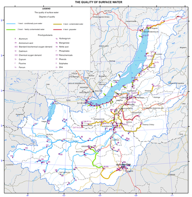
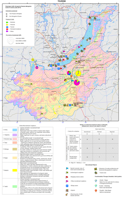
Qualitative characteristics of surface water summarised from the territorial reports are presented in the form of a map “Quality of surface water”, whose scale and information fullness are determined by the size of the lake’s catchment area. The original information for this map was taken from the governmental reports “On the state of Lake Baikal and measures for its protection” of the Republic of Buryatia and Irkutsk oblast, “Annual report on the quality of surface waters of the Russian Federation”, and the data provided by Mongolian scientists [National …, 2012, 2013; National …, 2013; Annual …, 2012]. To assess the state of water bodies, a specific index of water pollution (SIWP) was calculated from the most common contaminants of surface waters (see Methodology Instructions RD 52.24 643-2002). Water quality was assessed using SIWP and, as a result, five classes (categories) of water quality were identified in the examined water objects.</p>
<p>The water quality in the basin of the Selenga (the largest tributary of Lake Baikal) on the territory of Mongolia was classified according to the procedure similar to the Russian one. The main list and standards of chemical elements (dissolved oxygen, suspended particles, acidity, etc.) are almost identical for both countries [The harmonised monitoring program…, 2012]. The final classification of water bodies of the Selenga basin on the Mongolian territory was based on the calculated values of the water pollution index [Davaa, <a href="http://fofj.org/">http://fofj.org</a>] and brought into conformity with Russian classification.</p>
<p>
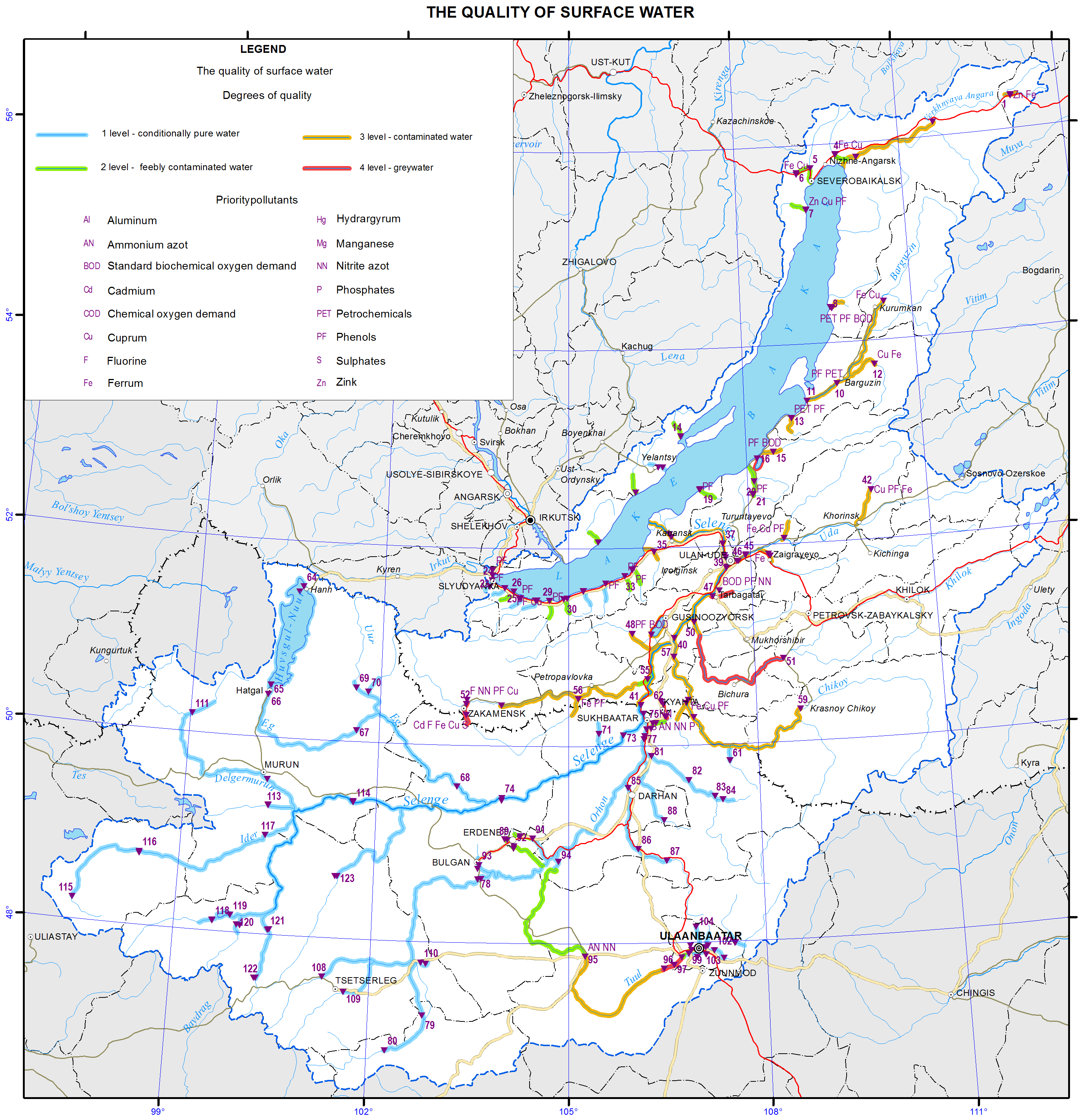
On the map, the water quality classes of water bodies are depicted by colored lines and supplemented by marks showing the places where samples of chemical elements that were the main pollutants for the given segment of the water body were taken. In the lake’s catchment area, the integral characteristic of the quality of surface water varies over a wide range from “conditionally clean” to “dirty” preeminently due to the different levels of economic development of the region.</p>
<p>
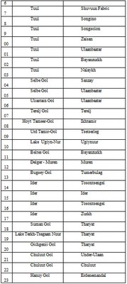
The major part of the lake catchment area belongs to the Selenga basin; the upper and central parts of the river are in Mongolia. The Selenga and a number of its large tributaries mainly cross underdeveloped territories and are not subject to significant pollution. The main large rivers of this area (the Delger-Muren, Ider, Orkhon, and Selenga) are characterized by high environmental indicators and practically pure (Class 1). The water in some areas of the hydrographic network of these streams that are adjacent to developed regions and subject to anthropogenic effect belong to Class 2 (“slightly polluted”). The Tuul river experiencing a severe anthropogenic impact (around Ulaanbaatar) significantly differs from other streams on the Mongolian territory: its surface water quality is classified as Class 4 (“dirty”). The main pollutants of this river are ammonium and nitrite nitrogen, phosphate, and sulphate. However, due to its self-purification processes occurring in the mouth area at the confluence with the Orkhon river the Tuul river water recovers to Class 1. The water in the Khiagt river on the northern border of Mongolia is also of low quality. This river brings its Class 4 waters to the territory of Buryatia (the Kyakhtinka river). Relatively low characteristics of the water quality (Classes 2 and 3) are recorded in some developed areas – in the Khangol (the town of Erdenet) and Orkhon (the town of Sukhbaatar) rivers.</p>
<p>
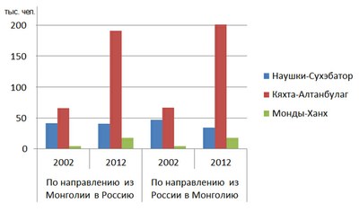
Up to the confluence with the Orkhon, the water quality of the Selenga in Mongolia is regarded as Classes 1 and 2. Further, below Sukhbaatar and the Orkhon’s mouth, the Selenga crosses the border to Russia. In Buryatia, its water quality is classified as Class 3 (“polluted”). The main pollutants of the river at the cross-section of Naushki are compounds of aluminium, iron and copper, the values of which exceed maximum permissible concentrations. Furtheron, the Dzhida river (together with the Modonkul river – Class 4) and the Kyakhtinka river (Class 4) join the Selenga. The first one is affected by the discharges of mine and drainage waters from the non-functional company JSC “Dzhida Combine”, while the second one contains elevated maximum permissible concentrations of 11 elements due to the transboundary transfer (the Khiagt river).</p>
<p>Large tributaries of the Selenga joining this river downstream bring polluted waters of Class 3. The most unfavourable situation is observed at some sites of the rivers Kuitunka, Chikoy, Khilok, and Uda, whose water quality is regarded as “polluted”. The main pollutants are different forms of nitrogen, organic substances, and phenol. The water in the lower Selenga is characterised as Class 3.</p>
<p>The quality of surface water in other largest tributaries of Lake Baikal is also low. Such large rivers as the Upper Angara, Barguzin and Turka have polluted waters of Class 3, whilst the water in smaller rivers such as the Tiya, Kholodnaya, Kika, Snezhnaya, Utulik, Buguldeika, and other are of Class 2. Phenols in combination with oil products, zinc, copper, and organic substances are typical contaminants of these rivers.</p>
<p>There is a scarce information on water quality in the lakes located on the examined territory as no monitoring has been conducted there. The exception is Lake Gusinoe, whose water quality is of Class 3 (“polluted”). The main pollutants of this lake are phenols, oil products, copper, and other substances. Moreover, the lake is subject to thermal pollution from the Gusinoozerskaya Thermal Power Plant. Another water body, Lake Kotokel, located within the Baikal basin has a very low water quality. The use of its water is prohibited for any purposes, except for technical use, which is confirmed by Decree No. 4 “On the Initiation of Restrictive Measures at Lake Kotokel” of the Chief Sanitary Inspector of the Republic of Buryatia, dated June 6, 2009, [On the state of …, 2013].</p>
<p>It should be noted that against the backdrop of the increased water discharge into water bodies of this territory in 2012, there is a trend of significant improvement of surface water quality of the Baikal basin.<b> </b>The water quality indicators in the majority of water bodies have been improved by 1-2 classes as compared to 2011 and previous years (On the state of …, 2012, 2013; Annual report …, 2012). <b> </b></p>
<p> </p>
<p align="center">References</p>
<p>Ministry of Natural Resources of the Russian Federation. (2012). <i>On the state of Lake Baikal and measures for its protection in 2011: State report</i>. Moscow. Retrieved from <a href="http://www.mnr.gov.ru/">http://www.mnr.gov.ru</a></p>
<p>Ministry of Natural Resources of the Russian Federation. (2013). <i>On the state of Lake Baikal and measures for its protection in 2012: State report</i>. Moscow. Retrieved from <a href="http://www.mnr.gov.ru/">http://www.mnr.gov.ru</a></p>
<p class="Default">The Sochava Institute of Geography SB RAS. (2013). <i>On the state and conservation of the environment in Irkutsk oblast in 2012: State report</i>. Irkutsk: The Sochava Institute of Geography SB RAS. p 337.</p>
<p>Hydrochemical Institute. (2012). <i>Annual report on the quality of surface waters of the Russian Federation in 2012</i>. Retrieved from <a href="http://www.ghi.aaanet.ru/">http://www.ghi.aaanet.ru</a></p>
<p>Methodology Instructions. <i>Method for a comprehensive assessment of pollution of surface waters using hydrochemical parameters</i>. RD 52.24.643-2002. Retrieved from <a href="http://www.opengost.ru/">www.OpenGost.ru</a></p>
<p class="Default">The Baikal Basin Information Center. (2012). <i>The harmonised monitoring program of water quality in the Selenga river basin</i>. Retrieved from <a href="http://baikal.iwlearn.org/">http://baikal.iwlearn.org/</a></p>
<p>Davaa, G., Oyunbaatar, D., &amp; Sugita. M. Surface water of Mongolia. Retrieved from <a href="http://fofj.org/">http://fofj.org/</a></p>
<p><img class="image-inline" src="../../../resolveuid/8ab4a641f7b64366a44f343cf70ed99b/@@images/image/preview" /></p>
<p><img class="image-inline" src="../../../resolveuid/d67bd6b239a943d3b369bf30ba816b82/@@images/image/preview" /></p>
<p><img class="image-inline" src="../../../resolveuid/58e43f91ba454fddb0ea9db3a53dc998/@@images/image/preview" /></p>
<p><img class="image-inline" src="../../../resolveuid/aa16f1c966d841e9ab2ad897cb711f3b/@@images/image/preview" /></p>]]></content:encoded>
    <dc:publisher>No publisher</dc:publisher>
    <dc:creator>Alexander Ayurzhanaev</dc:creator>
    <dc:rights></dc:rights>
    <dc:date>2014-10-10T05:55:00Z</dc:date>
    <dc:type>Page</dc:type>
  </item>


  <item rdf:about="http://bic.iwlearn.org/en/friends/the-nature-conservancy-in-mongolia-mongolia">
    <title>The nature conservancy in Mongolia (Mongolia)</title>
    <link>http://bic.iwlearn.org/en/friends/the-nature-conservancy-in-mongolia-mongolia</link>
    <description></description>
    <content:encoded xmlns:content="http://purl.org/rss/1.0/modules/content/"><![CDATA[<p style="text-align: center; "><b>THE NATURE CONSERVANCY IN MONGOLIA</b></p>
<p style="text-align: center; "><b><img class="image-inline" src="../../resolveuid/8984670d210c45da8b675eb858ae620c/@@images/image/preview" /></b></p>
<p><span style="text-decoration: underline;">Year of Establishment</span> 2008</p>
<p><span style="text-decoration: underline;">Contact details: </span>Amar Street-4, SBD-8, Ulaanbaatar, Mongolia</p>
<p>Tel: +1 (703) 841-5323<br /> Fax: +1 (703) 525-0208<span style="text-decoration: underline;"></span></p>
<p>Website <a href="mailto:eoidov@tnc.org">eoidov@tnc.org</a></p>
<p>e-mail <a href="mailto:asiapacific@tnc.org">asiapacific@tnc.org</a></p>
<p><span style="text-decoration: underline;">Head of the organization</span> Ms. Enkhtuya Oidov</p>
<p><span style="text-decoration: underline;">Scope of the activities</span><span style="text-decoration: underline;"></span></p>
<p>-         Working with the Mongolian government and conservation community to preserve natural resources, manage protected areas and slow environmental degradation.</p>
<p>-         Conducting workshops to introduce the Conservancy’s scientific methodology to Mongolian conservationists.</p>
<p>-         Assisting in the enhancement and design of Mongolia’s protected area network.</p>
<p>-         Helping preserve intact landscapes between protected areas so that wide-ranging species such as the Mongolian gazelle can continue seasonal migrations.</p>
<p>-         Working with eastern steppe stakeholders to create common conservation vision and goals.</p>
<p><span style="text-decoration: underline;">Mission</span> The mission of The Nature Conservancy is to conserve the lands and waters on which all life depends<span style="text-decoration: underline;"></span></p>
<p><span style="text-decoration: underline;">List of the environmental related projects implemented</span></p>
<p>-         Eastern steppe conservation projects</p>
<p>Protected area management in Toson Hulstai Nature Reserve.</p>]]></content:encoded>
    <dc:publisher>No publisher</dc:publisher>
    <dc:creator>Alexander Ayurzhanaev</dc:creator>
    <dc:rights></dc:rights>
    <dc:date>2015-02-09T03:32:42Z</dc:date>
    <dc:type>Page</dc:type>
  </item>


  <item rdf:about="http://bic.iwlearn.org/en/monitoring/the-harmonized-water-quality-monitoring-program-in-the-selenga-river-basin">
    <title>The harmonized water quality monitoring program in the Selenga river basin</title>
    <link>http://bic.iwlearn.org/en/monitoring/the-harmonized-water-quality-monitoring-program-in-the-selenga-river-basin</link>
    <description></description>
    <content:encoded xmlns:content="http://purl.org/rss/1.0/modules/content/"><![CDATA[<p> </p>
<div id="_mcePaste" style="text-align: center; "><img class="image-inline" src="../../resolveuid/3d87abab75e643ff8c6c5cb99677c4ba/@@images/image/preview" /></div>
<div style="text-align: left; ">The basin of Lake Baikal is one of the most outstanding ecosystems previously untouched by any significant impacts of economic activity. Preservation and maintaining of the natural condition of the Selenga river ecosystem (a part of Lake Baikal’s ecosystem) serve not only the national interests of the Russian Federation and Mongolia, but the entire world community.</div>
<div style="text-align: center; "></div>
<div>The surface waters condition and pollution monitoring system in the territory of Russia and Mongolia should be orientated towards strengthening of transboundary cooperation, acquisition of universal and commeasurable information. Alongside with the information on the condition of other environmental media it will serve as a basis for the support of executive decision making for the integrated water resource management in the basins of Lake Baikal and Lake Khubsugul to provide sustainable functioning and protection of the unique ecosystems under the conditions of economic development of the states concerned.</div>
<div></div>
<div id="_mcePaste">The harmonized water quality monitoring program in the Selenga river basin is aimed at the drawing together of the monitoring systems in Russia and Mongolia, exposure and fixing of discrepancies and disagreements in the course of its organization and maintenance.</div>
<div></div>
<div></div>
<p><a href="http://bic.iwlearn.org/en/documents-1/the-harmonized-water-quality-monitoring-program-in-the-selenga-river-basin" class="internal-link">Download file</a></p>]]></content:encoded>
    <dc:publisher>No publisher</dc:publisher>
    <dc:creator>Alexander Ayurzhanaev</dc:creator>
    <dc:rights></dc:rights>
    <dc:date>2015-02-09T04:30:00Z</dc:date>
    <dc:type>Page</dc:type>
  </item>


  <item rdf:about="http://bic.iwlearn.org/en/documents-1/the-harmonized-water-quality-monitoring-program-in-the-selenga-river-basin">
    <title>The harmonized water quality monitoring program in the Selenga river basin</title>
    <link>http://bic.iwlearn.org/en/documents-1/the-harmonized-water-quality-monitoring-program-in-the-selenga-river-basin</link>
    <description></description>
    
    <dc:publisher>No publisher</dc:publisher>
    <dc:creator>Alexander Ayurzhanaev</dc:creator>
    <dc:rights></dc:rights>
    <dc:date>2015-02-09T04:19:39Z</dc:date>
    <dc:type>File</dc:type>
  </item>


  <item rdf:about="http://bic.iwlearn.org/en/atlas/atlas/93-the-disturbance-of-vegetation-in-the-lake-baikal-basin-map/the-disturbance-of-vegetation-in-the-lake-baikal-basin-map">
    <title>The disturbance of vegetation in the lake Baikal basin map</title>
    <link>http://bic.iwlearn.org/en/atlas/atlas/93-the-disturbance-of-vegetation-in-the-lake-baikal-basin-map/the-disturbance-of-vegetation-in-the-lake-baikal-basin-map</link>
    <description></description>
    <content:encoded xmlns:content="http://purl.org/rss/1.0/modules/content/"><![CDATA[<p><img class="image-inline" src="../../../resolveuid/9768ae7881774f00bbb4e1df766e8cc8/@@images/image/preview" /></p>
<p><a href="http://bic.iwlearn.org/en/atlas/photos/copy_of__93_ThedisturbanceofvegetationinthelakeBaikalbasin.png" class="internal-link">Open full size</a></p>
<p align="center"><strong>Vegetation disturbance</strong></p>
<p>A cartographic evaluation of the anthropogenic disturbance of vegetation is the most effective method for solving numerous issues of environmental protection and the rational use of biotic resources in the Baikal basin. It was carried out taking into account the major changes in the floristic composition and cenotic structure of vegetation, which is developing mainly under the influence of anthropogenic factors. The degree of anthropogenic disturbance of the vegetation was determined by deviation criteria of the composition and structure of plant communities from their native state.</p>
<p>The evaluation is based on a modern universal map “Vegetation of the Baikal basin” 1:4, 000,000, which is created on the principles of a structural-dynamic classification of vegetation taking into account its main regional-typological features and dynamic processes caused by human and natural factors. Thus, invariants of epistructures of plant communities were established and thereby the base (zero) estimation level was defined, which was the starting point for the countdown of actual spontaneous and human-induced changes in the vegetation cover.</p>
<p>Besides the universal geobotanic map, basic cartographic sources were used in assessing the vegetation disturbances. These sources provide information about the boundaries of arable land and farmland and forests damaged by technogenesis, recreation, and harmful insects, burnt sites and regenerated cutover stands. Forest and land use management materials and Google 2013 surveying satellite images were used.</p>
<p>The disturbance of vegetation of the Baikal basin is determined primarily by its use as an industrial and agricultural resource, which is based on forests, grasslands and steppes.</p>
<p>Industrial logging leads to a change of indigenous coniferous stands to small-leaved, less valuable for the economy. Abandoned semi-subsistence raw materials on slashes increase forest fire debris and entomological danger. Light coniferous forests located in the riversides, especially on fertile soils used for agriculture, are often cut.</p>
<p>Besides logging, the forests in Irkutsk oblast, the Republic of Buryatia, Zabaikalsky krai, as well as in Mongolia are annually exposed to forest fire. Fire damages not only the forest but also the community of other vegetation types - mountain tundra, subalpine elfin cedar thickets, yerniks, steppes and others. That leads to the accumulation of large burnt areas, replacing native forests derivatives.</p>
<p>Negative impact on the steppe vegetation is also caused by plowing and irrational use of grazing territory. As for the pastural digression of vegetation, it has completely or partially changed the floristic composition and structure of many steppe and meadow communities.</p>
<p>In Mongolia, grazing currently remains the main type of agriculture. Here they raise cattle, sheep, camels, goats and horses, as well as Mongolian yaks and reindeer. Alpine pastures are even mountain-tundra, cryophyte steppe, marshy meadow and steppe. Vegetation communities of middle mountain, foothill, lowland areas and basins are widely used for pasture. Vegetation communities of floodplains and lakeshores with forest, meadow, prairie and wetland vegetation are especially strongly disturbed [Banzragch, et al, 1990].</p>
<p>In general, in Mongolia, as well as in Irkutsk oblast, the Republic of Buryatia and Zabaikalsky krai in the remote and undeveloped alpine areas, where there is no human activities, undisturbed (indigenous) vegetation is provisionally preserved. According to the development and availability of the areas, the assessment of vegetation disturbance is changing.</p>
<p>As a result of the analysis and assessment of vegetation communities, five categories of vegetation disturbance are identified on the map – conditionally drastic, weakly, moderately, and strongly disturbed and reformed.</p>
<p> </p>
<p align="center">References</p>
<p>Banzragch, D., Beckett, U., Buyan-Orshih, H., Munkhbayar, S., &amp; Tsedendash, T. (1990). The map: Types of pastures. Scale 1:3,000,000. <i>National atlas of the Mongolian People’s Republic</i>. Moscow-Ulaanbaatar. p 102-103.</p>]]></content:encoded>
    <dc:publisher>No publisher</dc:publisher>
    <dc:creator>Alexander Ayurzhanaev</dc:creator>
    <dc:rights></dc:rights>
    <dc:date>2014-10-13T00:25:00Z</dc:date>
    <dc:type>Page</dc:type>
  </item>


</rdf:RDF>
