<?xml version="1.0" encoding="utf-8" ?>
<rdf:RDF xmlns:rdf="http://www.w3.org/1999/02/22-rdf-syntax-ns#" xmlns:dc="http://purl.org/dc/elements/1.1/" xmlns:syn="http://purl.org/rss/1.0/modules/syndication/" xmlns="http://purl.org/rss/1.0/">


<channel rdf:about="http://bic.iwlearn.org/search_rss">
  <title>Байкальский информационный центр</title>
  <link>http://bic.iwlearn.org</link>

  <description>
    
            These are the search results for the query, showing results 251 to 265.
        
  </description>


  <image rdf:resource="http://bic.iwlearn.org/logo.png"/>

  <items>
    <rdf:Seq>
      
        <rdf:li rdf:resource="http://bic.iwlearn.org/en/friends"/>
      
      
        <rdf:li rdf:resource="http://bic.iwlearn.org/en/atlas/atlas/97-free-medical-care-system-map/free-medical-care-system-map"/>
      
      
        <rdf:li rdf:resource="http://bic.iwlearn.org/en/forum/forum-links"/>
      
      
        <rdf:li rdf:resource="http://bic.iwlearn.org/en/forum"/>
      
      
        <rdf:li rdf:resource="http://bic.iwlearn.org/en/atlas/atlas/52-forest-resources-and-their-use-map/forest-resources-and-their-use-map"/>
      
      
        <rdf:li rdf:resource="http://bic.iwlearn.org/en/atlas/atlas/130-fogs-map/fogs-map"/>
      
      
        <rdf:li rdf:resource="http://bic.iwlearn.org/en/atlas/atlas/29-floods-map/floods-map"/>
      
      
        <rdf:li rdf:resource="http://bic.iwlearn.org/en/documents/documents/papers/Fish%20nutrition%20in%20some%20small%20reservoirs%20of%20the%20Ivan-Arakhley%20system%20and%20their%20potential%20for%20piscicultural%20operations%20-rus.pdf"/>
      
      
        <rdf:li rdf:resource="http://bic.iwlearn.org/en/news/the-baikal-project/b47d69680c3666d58216d74f955eae61"/>
      
      
        <rdf:li rdf:resource="http://bic.iwlearn.org/en/atlas/atlas/44-ferrous-nonferrous-rare-and-precious-metal-resources-and-their-extraction-map/ferrous-nonferrous-rare-and-precious-metal-resources-and-their-extraction-map"/>
      
      
        <rdf:li rdf:resource="http://bic.iwlearn.org/en/friends/faction-green-russia-in-russian-united-democratic-party-yabloko-russia-buryat-republic"/>
      
      
        <rdf:li rdf:resource="http://bic.iwlearn.org/events/aggregator"/>
      
      
        <rdf:li rdf:resource="http://bic.iwlearn.org/events"/>
      
      
        <rdf:li rdf:resource="http://bic.iwlearn.org/en/documents/documents/papers/Estimation%20of%20forest%20biomass%20using%20satellite%20%20radar%20data%20-rus.pdf"/>
      
      
        <rdf:li rdf:resource="http://bic.iwlearn.org/en/atlas/atlas/112-environmental-protection-infrastructure-map/environmental-protection-infrastructure-map"/>
      
    </rdf:Seq>
  </items>

</channel>


  <item rdf:about="http://bic.iwlearn.org/en/friends">
    <title>Friends</title>
    <link>http://bic.iwlearn.org/en/friends</link>
    <description>The "Friends of Baikal Basin” NGO network </description>
    
    <dc:publisher>No publisher</dc:publisher>
    <dc:creator>Sergey Kudelya</dc:creator>
    <dc:rights></dc:rights>
    <dc:date>2013-03-02T07:35:24Z</dc:date>
    <dc:type>Folder</dc:type>
  </item>


  <item rdf:about="http://bic.iwlearn.org/en/atlas/atlas/97-free-medical-care-system-map/free-medical-care-system-map">
    <title>Free medical care system map</title>
    <link>http://bic.iwlearn.org/en/atlas/atlas/97-free-medical-care-system-map/free-medical-care-system-map</link>
    <description></description>
    <content:encoded xmlns:content="http://purl.org/rss/1.0/modules/content/"><![CDATA[<p><img class="image-inline" src="../../../resolveuid/3fbe9a4e710e4c318f0c03d56460881e/@@images/image/preview" /></p>
<p><a href="http://bic.iwlearn.org/en/atlas/photos/copy_of__97_FreeMedicalCaresystem.png" class="internal-link">Open full size</a></p>
<p align="center"><strong>Healthcare</strong></p>
<p align="center"><strong> </strong></p>
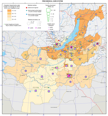
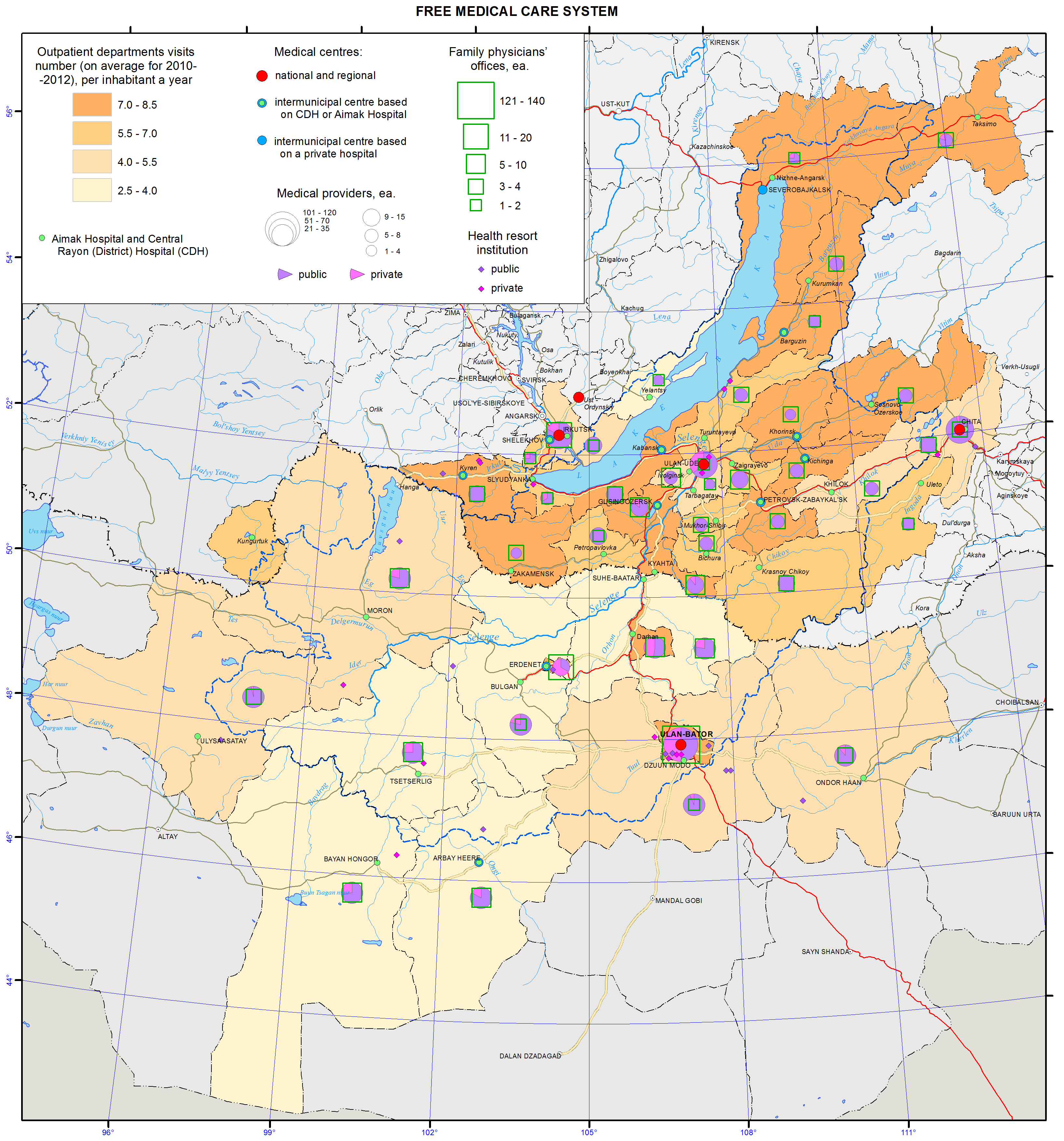
<p>Harsh climatic conditions across the entire territory of the Baikal basin and the surface and ground water used for drinking and food purposes that do not meet the drinking water quality standards (first and foremost in Mongolia and Buryatia) coupled with atmospheric emissions from industrial facilities and motor vehicles (in some parts of the territory) are responsible for the state of human health influencing the organization of healthcare. The ecological situation becomes substantially worse during winter months, which is encouraged by the topography of the terrain. In Mongolia, the spring period is very hard time to bear, with sharp temperature differences, abrupt variations in atmospheric pressure, and frequent dust and magnetic storms.</p>
<p class="NormalWeb">The organizational pattern of healthcare in Russia and Mongolia has much in common. This is a result of the cooperation of the two countries in this sphere and the fact that medical education and healthcare in Mongolia are organized using Russian experience. Today, Mongolian medical facilities operate on the principles of the state-private partnership concurrent with the demonopolization of the state system of medical services. The country has a mandatory and voluntary medical insurance system, in which state-owned and private medical institutions take part. The country also has various health institutes and centers.</p>
<p class="a">The territory of the Baikal basin is experiencing a deficit of medical workers. As of 2012, the availability of physicians varied from 13.8 to 30.1 per 10,000 people in Russian districts and from 16.1 to 29.0 per 10,000 people in Mongolian aimags. The availability of nurses varies from 25.1 to 112.2 per 10,000 people in Russian districts and from 26.4 to 38.2 per 10,000 people in Mongolian aimags. In Ulan-Ude, these indicators have the values of 53.9 and 117.3, while in Ulaanbaatar – 44.1 and 41.2, respectively.</p>
<p>The ratio of doctors and nurses in the Russian part of the basin is between 1:2 to 1:4, while in the Mongolian part it does not exceed 1:2. The World Health Organization (WHO) recommends that this ratio should be 1:4. A narrowing of this indicator causes imbalances in the healthcare system thereby limiting possibilities for further development of the after-treatment, casework and rehabilitation services.</p>
<p>Target indicators of healthcare activity are the standard volume of medical care per inhabitant. Currently, there are plans to decrease the per capita volume of in-patient services and increase the per capita volume of the hospital-replacing care. Accordingly, the number of hospital beds available 27/7 will decrease, while the number of beds in day hospitals will grow. Overall, the available number of hospital beds complies with the calculated standards and meets the demand of the population for the in-patient medical aid.</p>
<p class="ConsPlusNormal">As of today, in Russia, there is an array of problems relating to the high level of illnesses and disability incidences among the population, and these indicators are continuously growing. Such a situation is the result of inadequate preventive measures. Another important contributing factor to this situation is the increase of the proportion of elderly population and the improved effectiveness of illness detection using new diagnostic methods in the process of the increased number of medical checkups.</p>
<p class="ConsPlusNormal">The leading illnesses in the structure of morbidity are respiratory illnesses, bloodstream, eye, and digestive and musculoskeletal system diseases, as well as traumas. For many years, circulatory system diseases, neoplasms, and injuries have been the main causes of mortality and disability among the population.</p>
<p class="a">A complex of anthropogenic environmental factors contributes to the growth of morbidity and disability rates among the population with the most important one being air pollution. According to the WHO, atmospheric air pollution is the cause of up to 23% of all illnesses. The amount of pollutant emissions in the atmosphere produced by static sources in different administrative divisions in the Baikal basin differs by more than a thousand times. The most polluted air in the Baikal basin is in the Selenginsky district of Buryatia.</p>
<p>The health of the population and further development of healthcare depend on ecological, social, and economic factors. These problems can be resolved only through comprehensive approaches to the improvement of the quality of life of the population.</p>
<p>The strategic goal of the healthcare systems of Russia and Mongolia is to build a system, which ensures the quality and accessibility of medical services, primarily first aid, and increases the efficiency of medical services, based on the improvement of territorial planning of healthcare. The volume, types, and quality of these services should correspond to the rate of morbidity, population requirements, and the latest achievements of medical science, based on perfecting the system of territorial planning of public health services.</p>]]></content:encoded>
    <dc:publisher>No publisher</dc:publisher>
    <dc:creator>Alexander Ayurzhanaev</dc:creator>
    <dc:rights></dc:rights>
    <dc:date>2014-10-13T05:55:00Z</dc:date>
    <dc:type>Page</dc:type>
  </item>


  <item rdf:about="http://bic.iwlearn.org/en/forum/forum-links">
    <title>Forum links</title>
    <link>http://bic.iwlearn.org/en/forum/forum-links</link>
    <description></description>
    <content:encoded xmlns:content="http://purl.org/rss/1.0/modules/content/"><![CDATA[<table class="invisible">
<tbody>
<tr>
<th>
<p><a class="external-link" href="https://www.facebook.com/groups/baikalfriends/"><img class="image-left" src="../../resolveuid/6b402ceacda841e1a3d151de75e241a6/@@images/image/icon" /></a></p>
</th><th>
<p><a class="external-link" href="https://www.facebook.com/groups/baikalfriends/">Join the community</a></p>
<a class="external-link" href="https://www.facebook.com/groups/baikalfriends/"> </a>
<p><a class="external-link" href="https://www.facebook.com/groups/baikalfriends/">"Friends of the Baikal basin"</a></p>
</th>
</tr>
</tbody>
</table>
<p>The community "Friends of the Baikal basin" was created to strengthen join efforts of NGOs of Russia and Mongolia, which are working with environmental issues of lake Baikal.</p>]]></content:encoded>
    <dc:publisher>No publisher</dc:publisher>
    <dc:creator>Dmitry Popov</dc:creator>
    <dc:rights></dc:rights>
    <dc:date>2015-04-02T09:45:00Z</dc:date>
    <dc:type>Page</dc:type>
  </item>


  <item rdf:about="http://bic.iwlearn.org/en/forum">
    <title>Forum</title>
    <link>http://bic.iwlearn.org/en/forum</link>
    <description> </description>
    
    <dc:publisher>No publisher</dc:publisher>
    <dc:creator>Dmitry Popov</dc:creator>
    <dc:rights></dc:rights>
    <dc:date>2015-04-02T09:29:46Z</dc:date>
    <dc:type>Folder</dc:type>
  </item>


  <item rdf:about="http://bic.iwlearn.org/en/atlas/atlas/52-forest-resources-and-their-use-map/forest-resources-and-their-use-map">
    <title>Forest resources and their use map</title>
    <link>http://bic.iwlearn.org/en/atlas/atlas/52-forest-resources-and-their-use-map/forest-resources-and-their-use-map</link>
    <description></description>
    <content:encoded xmlns:content="http://purl.org/rss/1.0/modules/content/"><![CDATA[<p><img class="image-inline" src="../../../resolveuid/700ad65621bc487bbc5893966fe93356/@@images/image/preview" /></p>
<p><a href="http://bic.iwlearn.org/en/atlas/photos/copy_of__52_Forestresourcesandtheiruse.png" class="internal-link">Open full size</a></p>
<p align="center"><strong>Forest resources and their use</strong></p>
<p align="center"><strong> </strong></p>
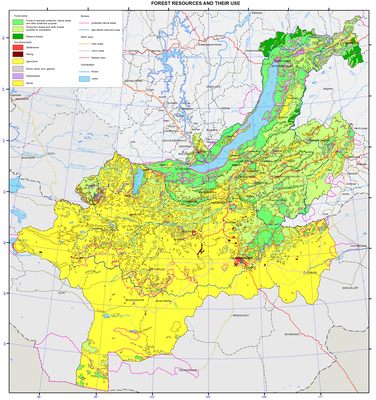
<p>The Baikal basin is a truly enormous treasury of "green gold." As of January 1, 2011 the forest area is 32103.6 thousand hectares in the Russian part of the basin and 10354.3 thousand hectares in Mongolia. Total timber reserves in the Russian part of the basin are 2,795,800,000 m3, with a stock of the conifers 2.443.000.000 m<sup>3</sup> (87.4 %). In Mongolia the total timber reserves is 1.373.100.000 m<sup>3</sup>.</p>
<p>The basic map shows the forests of nature conservation and other preservation patterns, as well as merchantable and other forests, suitable for commercial use, and reserved forests. It should be said that the division of forest lands into protected, merchantable and reserved is characteristic only of the Russian Federation. However, in the territory of Mongolia forests of special importance and in need of protection are distinguished, such as forest areas up to 100 hectares, forests on the slopes of the mountain areas of more than 30 degrees, etc.</p>
<p>Protected forests in Russia include forests subject to reclamation in order to maintain environmental, water protection, safety, sanitation, health and other useful features while using these forests providing compatibility with their intended purpose. Within the Baikal basin there is a high proportion of protected forests, due their ecosystemic, environment protection and water protection functions, as well as the important ecological role of montane forests. Merchantable<b> </b>forests are those which should be developed for the purposes of sustainable, maximum-efficiency rate production of high quality wood and other forest resources, as well as their conversion products ensuring the preservation of beneficial functions of forests. As far as the reserved forests are concerned, those are the forests not planned for logging for next twenty years. These forests are mostly located in the northern part of the region, in the permafrost zone, off-road area and are unattractive for development.</p>
<p>The insert map "Timber reserves by groups of the major forest forming species" shows the average reserves of softwood and hardwood forests (m3) per hectare of land covered by them. The average stand of timber per unit of the covered area is one of the indicators characterizing the productivity of forests, depending on growing conditions of stands, their species, and stands sparsity. The average stand of conifers and deciduous trees per hectare in the Russian part of the Baikal basin is 132.5 m3 (the global average is 100 m3/ha ), and it is fluctuating from 79-82 m3/ha (mostly in the steppe regions of Zabaikalsky krai, the Republic of Buryatia (Zaigraevsky, Chita districts) to 160 -170 m3/ha and up in the mid- and north areas (Uletovsky district of Transbaikalia, Kabansky and Severobaikalsky districts of the Republic of Buryatia, Irkutsky and Slyudyansky districts of Irkutsk oblast). Within the Mongolian part of the basin the average reserve of coniferous and deciduous tree stands is 126.6 m3 per one hectare with fluctuations in the aimaks from 81 to 205 m3 per ha. The highest average stand of timber per unit of forest area is characteristic of the northern mountainous areas of Mongolia.</p>
<p>Also this map shows the distribution of the total stand of timber by major groups of forest forming species (in million m3) with the method of cartodiagram. This index demonstrates forest-resource security area, which varies significantly in the districts of the Russian part of the basin and Mongolian aimaks (from 1.5 to 481 million m3). For correct depiction of the amount of total stand of timber within municipalities a conventional stepped scale for the circular cartodiagram was worked out, which enables to judge about the stands of timber for each group using the percentage between the major groups of forest forming species (coniferous, deciduous and shrubs).</p>
<p>Forest use is determined by the activities that have priority development within the forest vegetation areas. Timber harvesting is most developed among all kinds of forest utilization in the Russian part of the Baikal basin regulated by allowable cutting rates. Forests are actively used for recreation, hunting activities, etc.</p>
<p>In the analysis of forest utilization the following trends for all forests of the Baikal basin are revealed in recent years. They are reduction of coniferous stands, mostly maturing and mature stands; replacement of coniferous species by deciduous ones; widespread illegal logging, reduction of forested area due to fires, forest damage by pests, deforestation, and insufficient reforestation.</p>]]></content:encoded>
    <dc:publisher>No publisher</dc:publisher>
    <dc:creator>Alexander Ayurzhanaev</dc:creator>
    <dc:rights></dc:rights>
    <dc:date>2014-10-08T07:45:00Z</dc:date>
    <dc:type>Page</dc:type>
  </item>


  <item rdf:about="http://bic.iwlearn.org/en/atlas/atlas/130-fogs-map/fogs-map">
    <title>Fogs map</title>
    <link>http://bic.iwlearn.org/en/atlas/atlas/130-fogs-map/fogs-map</link>
    <description></description>
    <content:encoded xmlns:content="http://purl.org/rss/1.0/modules/content/"><![CDATA[<p><img class="image-inline" src="../../../resolveuid/2373960f555f475da742084bf54e7e49/@@images/image/preview" /></p>
<p><a href="http://bic.iwlearn.org/en/atlas/photos/copy_of__130_Fogs.png" class="internal-link">Open full size</a></p>
<p align="center"><strong>Fogs</strong></p>
<p align="center"><strong> </strong></p>
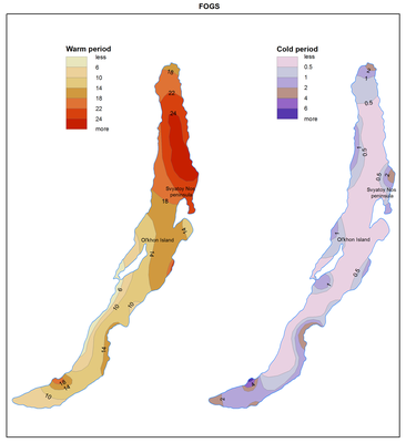
<p>Fogs at Lake Baikal form corresponding to sea fogs: they correlate with the relatively consistent seasonal drifting of air masses and with the seasonal distribution of winds. However due to the isolated inland location of the lake and the influence of the surrounding continental landmass, the Baikal fogs are to be classified as a separate type of advection fogs of large inland lakes and water reservoirs. The number of foggy days is the highest along the Northeast coast of Lake Baikal, and the lowest in the Central and the Southwest parts of the lake. The fogs lie mainly in the curves of the coastline, bays, coves, mouths of the rivers, flowing into Lake Baikal, and the numerous creek valleys that open towards the lake. In the annual cycle, the fogs are most frequent in July. The Northern stations report higher frequency of fogs in summer and register a single sharp peak in July. The Southern stations report lower frequency of fogs in the annual cycle, while the annual peak is extended over June, July and August.</p>
<p>At Lake Baikal, condensation prevails in summer, and evaporation – in winter. In the warm season, fogs are formed by passing of a warm front, or within a diffused pressure field above the wet underlying terrain. These fogs are formed by condensation of vapor in a mass of air warmed up above the land as it passes over the cold water. Summer fogs are very dense and persistent, especially in the first half of summer.</p>
<p>Evaporation fogs occur during the сold season. Until the lake freezes over, these fogs continuously stay above the water surface or can be lifted into low cloud. In winter, the Siberian Highland ground inversions accompanied by significant fall of temperature form radiation fogs. Winter fog formation is most commonly connected with advection of cold air over the warmer water surface. In cold season, as well as during the summer months, other types of fog can occur at Lake Baikal, caused by various reasons: temperature gradient between land and sea, the occurrence of floe patches and clear water surface, clearings in the fast ice of Lake Baikal.</p>
<p>Forecasting Baikal fogs requires an integrated approach with attention to such factors as their movability and the complexity of their formation processes. One has to take into account the general meteorological situation, the character of breeze/monsoon circulation in the area, the influence of coastline. It is important to consider the influence of West winds on the fog formation at the East coast, especially in winter.</p>]]></content:encoded>
    <dc:publisher>No publisher</dc:publisher>
    <dc:creator>Alexander Ayurzhanaev</dc:creator>
    <dc:rights></dc:rights>
    <dc:date>2014-10-15T02:00:00Z</dc:date>
    <dc:type>Page</dc:type>
  </item>


  <item rdf:about="http://bic.iwlearn.org/en/atlas/atlas/29-floods-map/floods-map">
    <title>Floods map</title>
    <link>http://bic.iwlearn.org/en/atlas/atlas/29-floods-map/floods-map</link>
    <description></description>
    <content:encoded xmlns:content="http://purl.org/rss/1.0/modules/content/"><![CDATA[<p><img class="image-inline" src="../../../resolveuid/9e12e2631dc94ca08fd88f97f030f2af/@@images/image/preview" /></p>
<p><a href="http://bic.iwlearn.org/en/atlas/photos/copy_of__29_Floods.png" class="internal-link">Open full size</a></p>
<p align="center"><strong>Floods</strong></p>
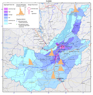
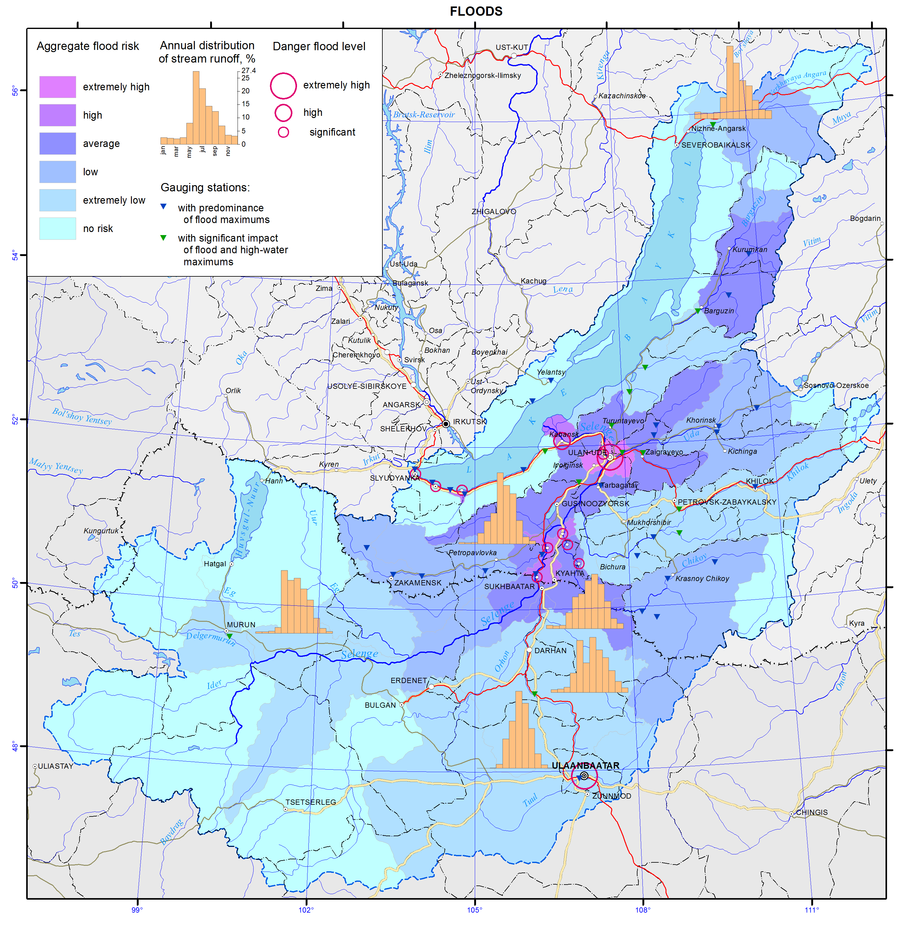
<p>The aim of the flood map is to give an insight into distribution of flooding risk on the territory, and level of its danger to human activity and facilities of national economy. The map was compiled on the basis of reference materials of the national water resource inventory [Long-term…, 1986; Resources …, 1973], data on the flooding damage, and archival and cartographic materials.</p>
<p>Flood hazard is characterized by their genesis, recurrence, impact, damage, possibility and appropriateness of forecasting a dangerous situation. T.A. Borisova determined the integral risk of floods from the territorial assessment of risk caused by floods [Borisova, 2013] using private maps of disturbances of land of different categories and population (based on the estimation of physical, economic and social risks). Flood danger for the rivers of Southern Baikal flowing from the Khamar-Daban Ridge is determined through an expertise as there are no appropriate calculated data.</p>
<p>Severe floods take place at the Selenga, Khilok, Uda, Upper Angara, and Barguzin rivers. The depth of floodplain inundation does not exceed 0.5-1 m during common floods and reaches 1.8-3 m during severe floods. The height of the water layer increases downstream the rivers: for example, its height at the Selenga river near the settlement of Ust-Kyakhta is 1 m and near the city of Ulan-Ude increases up to 3 m. The longest floods (30-90 days) are observed in the valley of the Selenga river and downstream the  river. Shorter floods (up to 25 days) are recorded in the basins of the Barguzin, Upper Angara, Uda, Dzhida, and other rivers. The duration of floods at small rivers, flowing directly to Lake Baikal, is, as a rule, 3-7 days.</p>
<p>The increase of water levels and flow rates in the rivers under study are observed during spring floods caused by thawing of snow cover and glaciers and during summer rain floods. High water floods are not characteristic of rivers located in the southern part. Spring floods are observed in the rivers of the Selenga basin, as well as in the streams running from the Khamar-Daban and Primorsky Ridges. The rivers with spring-summer floods are located in the northern part of the territory (Upper Angara, Barguzin, Turka, Tyya, Rel, Goudzhekit, and others).</p>
<p>Breakup of the ice is often accompanied by ice jams resulting in sharp short-term water level increases. Such local floods are confined to certain areas of narrowing riverbeds or river oxbows. Areas where ice jams are most likely to occur are noted on the Selenga River (Omulyovka Mountain – village of Voznesenovka – Mostovoy sidetrack – settlement of Reid, etc.).</p>
<p>Rain floods usually start from the decrease of spring flood and are observed during the entire summer period. The highest water levels are usually recorded in July-August. The highest intensity of the water level increase is registered at the rivers of the Selenga basin. For instance, during the highest flood in 70 years on the Dzhida River (19/1) it was 4.5 m per day (Khamney level gauge) and 2.79 m per day (Dzhida level gauge). Besides, rapid water level increases of a number of mountain stream tributaries (Khamney, Kurba, Ona, etc.) are associated with their location in the permafrost zone which considerably decreases the infiltration capacity of the soils. Fluctuations of water levels in the Selenga river and in the lower reaches of its tributaries are smoother, which is attributed to the spreading of floods and regulatory influence of the plains. However, the damage from the floods in this area is the most severe as the floodplains are the deepest and flooding is the longest. Moreover, this territory is highly developed economically and densely populated.</p>
<p>Maxima of rain floods on the territory under study significantly prevail over the maxima of spring floods in both absolute value and their number of the total annual maxima [Kichigina, 2000]. The first ones are the most dangerous for the flood formation. The exception is some rivers in the northern regions (Upper Angara, Barguzin, Rel, and Tyya) where the spring flood is the main water regime phase. The map represents the distribution of cross-sections with the dominance of rain flood maxima and with comparable contribution of spring and rain flood maxima. Rain floods cause huge damage as they are widely spread, repeat many times and have a high rate of formation. They can flood both separate small basins and vast territories. Their timely and precise forecast is, as a rule, low. For example, the destructive rain flood that happened in July of 1966 caused a 3 m water increase in the Tuul river, and for several hours the city of Ulaanbaatar submerged and 130 people drowned.  Only for the Republic of Buryatia the damages in the Selenga river basin amounted to about 1.4 billion roubles in 1971, 0.7 billion roubles in 1973 and 40 billion roubles in 1993 (based on current prices). In Mongolia the damages are considerably lower due to the specific settlement patterns and the unique features of the economic use of alluvial lands.</p>
<p>On the southern coast of Lake Baikal (from the Mysovka River mouth to the Angara River outlet), on the south-eastern slope of the Baikal Ridge and in a number of the Selenga River tributaries, floods are often aggravated by mud flows [Makarov, 2012]. Mud floods are caused by heavy rains at the sites with significant slope steepness and easily washed-away loose soil. Mud flow processes mostly develop in the near-mouth areas of the rivers of the northern slope of the Khamar-Daban Ridge and along the Circum-Baikal railway. Mud flows have very destructive force, and they are able to cause significant damages. The increase of water level in such small rivers as the Pokhabikha, Tiganchikha and others can be caused by thawing of ice crust formed as a result of freezing of their river beds.</p>
<p>In general the rivers in the Baikal basin are related to high flood probability ones. Small floods on certain rivers are registered almost annually. Recurrence of severe floods over the period from 1936 to 2012 amounts to 5-12%. According to statistics the most severe last century’s floods were registered in 1932, 1936, 1971, 1973, 1993 and 1998.</p>
<p>The height of the water level on the floodplain and the duration of high water stand are important characteristics. The height depends on both severity of a flood and hydrological and morphological properties of a river. During floods on the Selenga river near the village of Ust’-Kyakhta is comes to 1-2 meters; in the conditions of a narrowing valley and a sufficient stream supply by the Dzhida and Chikoy rivers near the village of Novoselenginsk it sharply rises and may exceed 4 meters. By the city of Ulan-Ude it drops down to 2.2 meters and to 1 meter in the vast delta.</p>
<p>The duration of high water stand varies. Long-term water floods on a floodplain (25-40 days) are observed in the valley of the Selenga river and in the lower course of the Chikoy river. Shorter-term floods (up to 25 days) are registered in the basins of the Barguzin, Upper Angara, Uda and Dzhida and other rivers. On small mountain streams floods usually do not exceed 3-7 days.</p>
<p>3 to 5% of the basin’s territory is exposed to recurrent floods. However, these are largely the most developed and settled lands. For instance, within the Russian part of the Selenga river basin about 4.000 sq km of inundated landscapes may be exposed to flooding; 231.600 hectares or 9.5% are agricultural lands. On the rivers of the northern part (the Barguzin, the Upper Angara) almost 2.000 sq km are flooded, a quarter of them agricultural lands.</p>
<p>The list of settlements on the territory of the Baikal basin, which are at risk of flooding, was compiled using summarized archival and reference data. In total, 75 settlements were included into the flood zone. The settlements with the highest risk of flooding are marked on the map.</p>
<p><b> </b></p>
<p align="center">References</p>
<p>Borisova, T.A. (2013). <i>Natural-anthropogenic risks in the Lake Baikal basin.</i> Chief Ed. A. Tulokhonov, Novosibirsk: Akad. Izd-vo “Geo”, 2013, 126 p.</p>
<p class="1">Kichigina, N.V. (2000). Genetic and statistic analysis of maximal flow of rivers in South-East Siberia. In: <i>Natural and socio-economic conditions of Siberian regions.</i> Novosibirsk: Izd-vo SO RAN, pp. 19-22.</p>
<p>Makarov, S.A. (2012). <i>Mud flows in Cisbaikalia.</i> Irkutsk: Izd-vo Instituta geografii im. V.B. Sochavy SO RAN, 111 p.</p>
<p><i>Long-term data on regime and resources of surface land waters.</i> (1986). Leningrad: Gidrometeoizdat, issue 13, 346 p.; issue 14, 282 p.</p>
<p><i>Surface water resources of the USSR.</i> (1973). Leningrad: Gidrometeoizdat, 1972, vol. 16, issue 2, 586 p.; vol. 16, issue 3, 400 p.</p>]]></content:encoded>
    <dc:publisher>No publisher</dc:publisher>
    <dc:creator>Alexander Ayurzhanaev</dc:creator>
    <dc:rights></dc:rights>
    <dc:date>2014-10-07T02:55:00Z</dc:date>
    <dc:type>Page</dc:type>
  </item>


  <item rdf:about="http://bic.iwlearn.org/en/documents/documents/papers/Fish%20nutrition%20in%20some%20small%20reservoirs%20of%20the%20Ivan-Arakhley%20system%20and%20their%20potential%20for%20piscicultural%20operations%20-rus.pdf">
    <title>Fish nutrition in some small reservoirs of the Ivan-Arakhley system and their potential for piscicultural operations (rus).</title>
    <link>http://bic.iwlearn.org/en/documents/documents/papers/Fish%20nutrition%20in%20some%20small%20reservoirs%20of%20the%20Ivan-Arakhley%20system%20and%20their%20potential%20for%20piscicultural%20operations%20-rus.pdf</link>
    <description></description>
    
    <dc:publisher>No publisher</dc:publisher>
    <dc:creator>Alexander Ayurzhanaev</dc:creator>
    <dc:rights></dc:rights>
    <dc:date>2014-03-28T13:15:00Z</dc:date>
    <dc:type>File</dc:type>
  </item>


  <item rdf:about="http://bic.iwlearn.org/en/news/the-baikal-project/b47d69680c3666d58216d74f955eae61">
    <title>First Steering Committee Meeting</title>
    <link>http://bic.iwlearn.org/en/news/the-baikal-project/b47d69680c3666d58216d74f955eae61</link>
    <description>22 Nov 2011 in Ulan-Ude, Russia the First Steering Committee Meeting was held.</description>
    <content:encoded xmlns:content="http://purl.org/rss/1.0/modules/content/"><![CDATA[<div>
<p style="text-align: left;"><a class="internal-link" href="http://baikal.iwlearn.org/en/project/steering-committee/first-meeting/agenda-in-english">Agenda </a>of meeting included the<strong> </strong>presentation of the project to the <a class="internal-link" href="http://baikal.iwlearn.org/en/project/steering-committee">Steering Committee</a> members and observers including overview of the project goals, objectives and outcomes; coordination, implementation and management arrangements; GEF M&amp;E requirements. Also it was a discussion on the project governance, strategy and priorities.</p>
<p style="text-align: left;"><a class="internal-link" href="http://baikal.iwlearn.org/en/contacts/project-manager">Project manager</a> presented the <a class="internal-link" href="http://baikal.iwlearn.org/en/project/steering-committee/first-meeting/s.kudelya">budget </a>and <a class="internal-link" href="http://baikal.iwlearn.org/en/project/steering-committee/first-meeting/first-year-workplan">working plan</a> for the project first year.</p>
<p style="text-align: left;">The results of discussions and <a class="internal-link" href="http://baikal.iwlearn.org/en/project/steering-committee" style="text-align: left;">Steering Committee</a> resolution was published in<a class="internal-link" href="http://baikal.iwlearn.org/en/project/steering-committee/first-meeting/Steering%20Committee%20First%20Meeting%20Minutes%20final%20eng.doc"> the minutes</a>.</p>
</div>]]></content:encoded>
    <dc:publisher>No publisher</dc:publisher>
    <dc:creator>Sergey Kudelya</dc:creator>
    <dc:rights></dc:rights>
    <dc:date>2013-03-02T08:05:31Z</dc:date>
    <dc:type>Feed Item</dc:type>
  </item>


  <item rdf:about="http://bic.iwlearn.org/en/atlas/atlas/44-ferrous-nonferrous-rare-and-precious-metal-resources-and-their-extraction-map/ferrous-nonferrous-rare-and-precious-metal-resources-and-their-extraction-map">
    <title>Ferrous, nonferrous, rare and precious metal resources and their extraction map</title>
    <link>http://bic.iwlearn.org/en/atlas/atlas/44-ferrous-nonferrous-rare-and-precious-metal-resources-and-their-extraction-map/ferrous-nonferrous-rare-and-precious-metal-resources-and-their-extraction-map</link>
    <description></description>
    <content:encoded xmlns:content="http://purl.org/rss/1.0/modules/content/"><![CDATA[<p><img class="image-inline" src="../../../resolveuid/c0893da58701459699e0f5004007f3b0/@@images/image/preview" /></p>
<p><a href="http://bic.iwlearn.org/en/atlas/photos/copy_of__44_Ferrousnonferrousrareandpreciousmetalresourcesandtheirextraction.png" class="internal-link">Open full size</a></p>
<p><img class="image-inline" src="../../../../resolveuid/086337cddf4549b08338fd489baddd69/@@images/image/preview" /></p>
<p><a href="http://bic.iwlearn.org/en/photos/copy_of__44_Table.png" class="internal-link">Open full size</a></p>
<p align="center"><strong>Resources of ferrous, nonferrous and rare metals and their mining</strong></p>
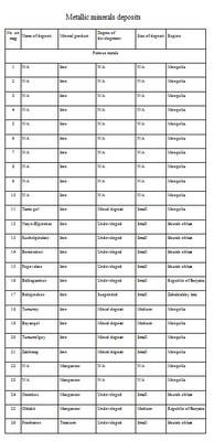
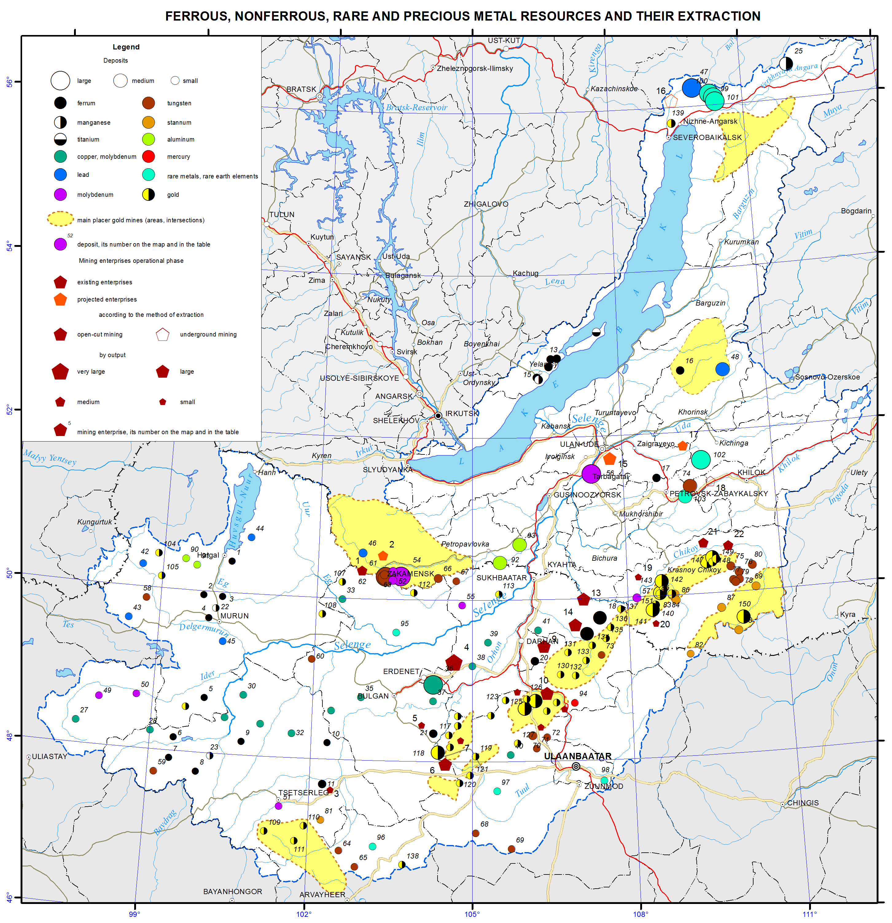
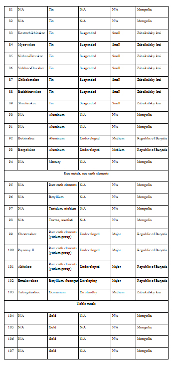
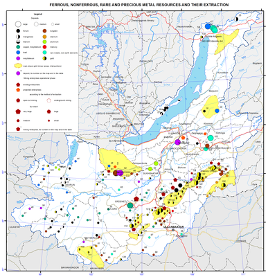
<p>Geological exploration exposed over 150 deposits of metallic minerals within the Baikal basin.<b> </b></p>
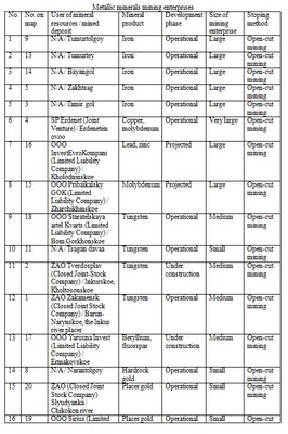
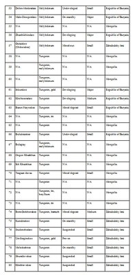
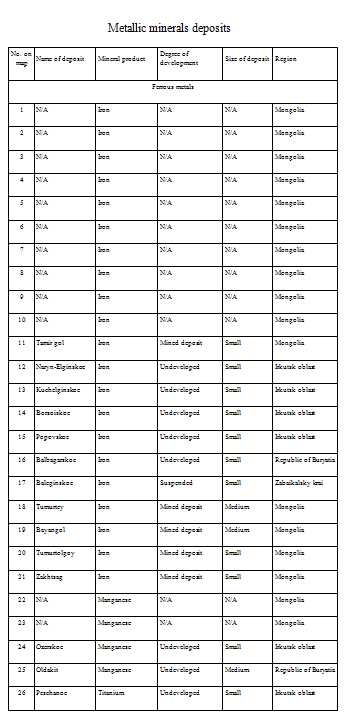
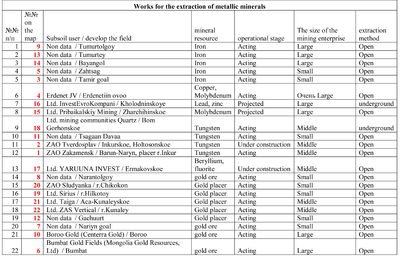
<p><b>Ferrous metals</b> are represented by a number of iron ore deposits of different genetic types, including two small magnetite deposits, namely, Balbagarskoe in the territory of the Khorinsky municipal district of the Republic of Buryatia and Baleginskoe in the Petrovsk-Zabaikalsky district of Zabaikalsky krai. In the 18<sup>th</sup>-19<sup>th</sup> centuries the Baleginsky mine supplied iron ore to the Petrovsky plant to procure iron and steel for the mines of the Nerchinsky district. In the Olkhonsky municipal district of Irkutsk oblast small iron ore deposits are known; they are mainly represented by brown iron ore deposits (Borsoiskoe, Kuchelginskoe, etc.). In the first half of the 18<sup>th</sup> century, ore from these deposits was used for the needs of the Anginsky (Laninsky) ironworks. The most promising iron ore deposits of Mongolia are the skarn type deposits such as Tumurtolgoy, Bayangol, and Tumurtey, forming the Bayangol iron ore zone in the north of the country. Currently, iron ore deposits in the region are developed only in the territory of Mongolia: small scale extraction of iron ore is underway on the Zakhtsag and Tamir gol deposits; over the recent years, the production on the deposits of the Bayangolskaya iron ore zone amounted to more than five million tons; primary processing is performed at the cleaning plants near the deposits; iron-ore concentrate is exported to China.</p>
<p>The Oldakit manganese deposit, medium in terms of reserves, is located in the Severobaikalsky municipal district less than 30 km from the Baikal-Amur Mainline. Given the fact that Russia is currently experiencing shortage of this raw material, the deposit may be of some interest. Moreover, several small deposits of manganese are known within the boundaries of the Baikal basin, including the Ozerskoe deposit (Olkhonsky district) developed in the 19<sup>th</sup> century for the needs of the Nikolaevsky ironworks.<b></b></p>
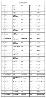
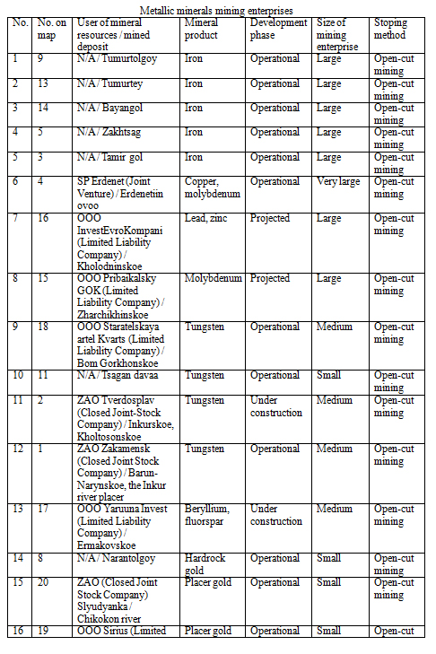
<p><b>Nonferrous metals</b>. Almost all reserves and resources of copper ores of the region are concentrated in complex copper-molybdenum and molybdenum-tungsten deposits of Mongolia, located within the Selenginsky volcanoplutonic belt. From 1978 to present a large deposit Erdenetiyn ovoo has been developed; on its basis a joint Soviet-Mongolian venture, the Erdenet Mining Company was established. The plant is engaged in open-pit mining and primary processing of copper-molybdenum ores and is one of the world leaders in the production of copper concentrate. Currently, the production output amounted to more than 25 million tons of ore, while the production of copper concentrate is about 350 thousand tons. In a globalizing world economy, the company faces the challenge of marketability of its products, which necessitates the construction of a copper-smelting plant. At present, the Erdenet Mining Company comprises a pilot plant for the production of pure cathode copper from off-balance and storage ore dump piles of KOO (Limited Liability Company) “Erdmin”, which is a joint venture of Erdenet Mining Company and the American company RCM.</p>
<p>Within the Baikal basin, the largest Kholodninskoe deposit of lead-zinc sulfide ores is explored and prepared for industrial development; its reserves amount to 11.2% of Russia’s total lead reserves and 34.1% of Russia’s total zinc reserves. Based on the economic indicators of development, the deposit is on par with the best world analogues. According to the feasibility study of final mining parameters, the annual production of the underground mine at the deposit should amount to three million tons of ore, 504 thousand tons of zinc concentrate, and 60.3 thousand tons of lead concentrate. In order to ensure environmental safety of production, provision is made for a circulating water supply system, transportation of wastes of the ore-dressing plant outside the catchment area of Lake Baikal using pipelines, and a number of other environmental measures. However, due to the fact that the deposit is located in the Central Ecological Zone of the Baikal Natural Territory (BNT), where mining activity is banned, the production license, owned by the KOO (Limited Liability Company) “InvestEuroCompany” was suspended until 2015. Among other objects of polymetallic raw materials in the region, the medium Davatkinskoe deposit, discovered and assessed in the Khorinsky municipal district of the Republic of Buryatia, should be pointed out.</p>
<p>In Buryatia there are two large deposits of molybdenum ores, namely, Zharchikhinskoe and Malo-Oinogorskoe, and small Pervomaiskoe (abandoned) and Dolon-Modonskoe (undeveloped) deposits. There is a project of the construction of the Pribaikalsky mining and processing plant on the basis of the Zharchikhinskoe deposit, located 40 km to the south of Ulan-Ude in close proximity to the highway and railway, with the molybdenum content in the ore of more than 0.1% and high technological and technical-economic indicators. Its effective development is possible, provided that all necessary environmental requirements are observed.</p>
<p>Tungsten in the region belongs to widespread elements. In the territory of the Zakamensky municipal district there is the Inkurskoe deposit of the stockwork geological-industrial type, which is comparable to the largest similar deposits of the world in terms of its reserves and tungsten content. The Kholtosonskoe deposit, located to the west of the Inkurskoe one, is the largest deposit of the vein type in Russia, and is considered to be unique not only in Russia but also in the world as to its characteristics. The Dzhidinsky tungsten-molybdenum mill operated from 1934 to 1996 on the basis of these two deposits as well as the Pervomaiskoe molybdenum deposit. After the closure of the mill, the tailings pond remained over the area of more than ​​one km<sup>2</sup>, forming the man-made Barun-Narynskoe deposit, the development of which has been started by OAO (Open Joint Stock Company) “Zakamensk” since 2010. A reclamation plant recycling the mill’s waste was built 1.5 km from the town of Zakamensk; the concentrate production amounts to about 300 tons per annum. ZAO (Closed Joint Stock Company) “Tverdosplav” is engaged in the construction of mining sites at the Inkurskoe and Kholtosonskoe deposits. It is planned to build a modern ore-dressing plant and a hydrometallurgical workshop for the processing of tungsten concentrates to produce commercial refined tungsten compounds. In the Petrovsk-Zabaikalsky municipal district of Zabaikalsky krai the prospectors' artel “Kvarts” mines the medium Bom-Gorkhonskoe tungsten deposit by the underground mining method. In recent years, the concentrate production amounted to around 600 tons. The remaining tungsten deposits within the territory of the Russian part of the Baikal basin are temporarily abandoned or are on the governmental standby.</p>
<p>A number of tungsten deposits are known in Mongolia. A small tungsten refinery plant was built on the Tsagaan davaa deposit; the concentrate production amounts to about 40 tons per annum; the final production is exported to the United States and China.</p>
<p>Tin deposits located in the Krasnochikoysky district are small in terms of reserves and are currently mothballed.</p>
<p>In the Dzhidinsky district of Buryatia the medium Borgoiskoe (Al2O3 – 19.8% on average) and Botsinskoe (21.44%) deposits of nepheline-bearing rocks are prospectively explored; currently they remain undeveloped.<b></b></p>
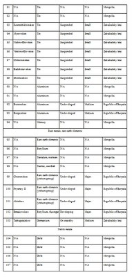
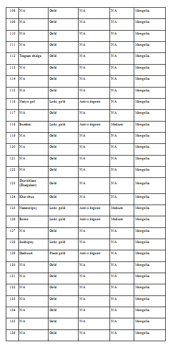
<p><b>Rare metals.</b> In the Kizhinginsky municipal district of the Republic of Buryatia there is the Ermakovskoe deposit of beryllium ores containing 80% of the total beryllium reserves of Russia and unique as to the grade of ore. From 1978 the deposit was developed by the Zabaikalsky mining and processing plant; in 1990 the enterprise was mothballed. Beryllium is a strategic metal essential for the development of nuclear, aerospace, and aviation industry, and instrument engineering; it is used in the manufacture of telecommunications equipment. Currently, Russia’s demand of this metal is met through imports. Whereas it is necessary to restore the raw material and production independence of the country in beryllium, it is expected to resume the production of ore on the deposit, and create production on primary processing of ore, as well as hydrometallurgical production, the end product of which – beryllium hydroxide – will be delivered to the Ulbinsky metallurgical plant in Kazakhstan for processing and producing beryllium alloying compositions and metal. The work to create the beryllium production is included in the Federal Target Program on rare metals of paramount importance.</p>
<p>In the Severobaikalsky municipal district within the Central Ecological Zone of the BNT, three subsoil plots of the Federal importance with large prognostic resources of rare earth elements of the yttrium group are on the governmental standby. They are the Chestenskoe, Akitskoe and Pryamoy-II deposits.<b></b></p>
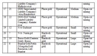
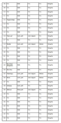
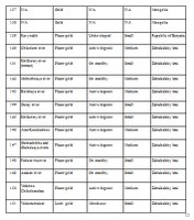
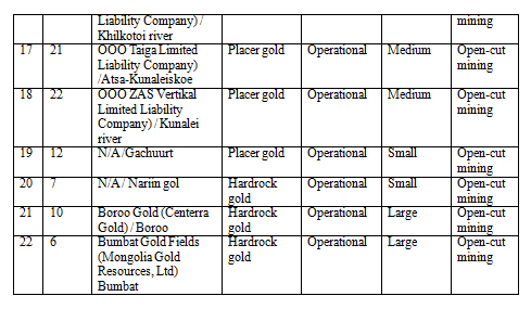
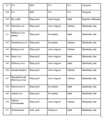
<p><b>Noble metals. </b>Within the Russian part of the Baikal basin there are no lode gold deposits (except the mined-out Voskresenskoe deposit in the Krasnochikoysky municipal district). Placer gold deposits are small or medium and are grouped into the gold-placer regions, namely: Dzhidinsky, Namaminsky, Yambuy-Tolutaisky, Chikoysky, and Baldzhikansky. In the Republic of Buryatia within the territory under consideration gold practically has not been produced over the recent three years (economically advantageous deposits are mined-out, and exploration and appraisal works require substantial expenditures); in the Krasnochikoysky district of the ​​Zabaikalsky krai, four prospectors' artels produce 300-400 kg of gold annually using the open-pit hydromechanical method.</p>
<p>Gold is the second most significant mineral resource of Mongolia after copper. The industrial mining of gold ores in the country was launched in the early 20<sup>th</sup> century by the Russian-Mongolian joint-stock company “Mongolor” in the Iro-Gol river basin, in the Khovsgol region and in the Boroo area. Primary deposits are usually of the vein type, more rarely – mineralized zones. The most significant primary deposits in terms of reserves include the Boroo deposit in the Boroo-Zuunmod region and the Bumbat deposit in the Zaamarsky gold field. The metal content in individual layers reaches 10 g/t. The deposits are developed by Canadians with the annual production of five and 1.5 tons of metal, respectively. Moreover, gold is currently mined on the Narantolgoy and Nariyn gol deposits.</p>
<p>Among the placers small and medium ones predominate, and only single ones are large placers in terms of reserves. Most placers are shallow single-layer, rarely double-layer; in rare cases deep placers occur. Dredging and separate production techniques are applied at the placer deposits. After mining by large companies, the remaining gold is mined by individual prospectors, whose number exceeded 10 thousand people according to the official data alone. In river valleys, where mining is possible, huge settlements are formed. As a result, in recent years the country faced an intensive shallowing and pollution of rivers, shrinking of grazing lands for cattle, and a process of desertification of the southern territory, and drinking water shortages for population occur. This is largely due to huge volumes of gold mining in the river valleys, illegal use of mercury and cyanides, and almost total lack of reclamation.</p>
<p>The map symbols show metallic mineral deposits depending on their size and type of commercial minerals. Mining companies are also shown with symbols. The size of a symbol corresponds to the production output. The group of large companies include ferrous, nonferrous and rare metals producing enterprises with production ranging from 1 to 10 million tons of ore per annum, the group of medium ones comprises the production output of 0.1-1 million tons per annum,</p>
<p><img class="image-inline" src="../../../../resolveuid/b5bd74556d5045bcac18238e545cd3c4/@@images/image/preview" /></p>
<p><a href="http://bic.iwlearn.org/en/photos/44.jpg" class="internal-link">Open full size</a></p>
<p><img src="http://bic.iwlearn.org/en/photos/441.jpg/@@images/9854ac0a-f6fc-46c7-b910-b40a35514466.jpeg" alt="" class="image-inline" title="" /></p>
<p><a href="http://bic.iwlearn.org/en/photos/441.jpg" class="internal-link">Open full size</a></p>
<p>and small ones produce less than 0.1 million tons per annum. The Erdenet Mining Company is highlighted as a very large enterprise with an annual production of more than 20 million tons. The following gradation is accepted for gold mining: large companies are gold mines with the production of more than one ton per annum, medium companies are those producing 0.1-1 ton, and small ones are those with less than 0.1 tons produced. The color of the symbol corresponds to the exploitation phase of an enterprise: operating or projected and under construction; additional outline corresponds to the underground mining method. Gold-placer regions of the given territory are depicted by areals.</p>
<p>Table 1</p>
<p><img class="image-inline" src="../../../../resolveuid/f4a37e81d4d7431fbf95f7265a1b458e/@@images/image/preview" /></p>
<p><a href="http://bic.iwlearn.org/en/photos/442.jpg" class="internal-link">Open full size</a></p>
<p><img class="image-inline" src="../../../../resolveuid/1441b8be04934550bc0ebb4c83b9c44e/@@images/image/preview" /></p>
<p><a href="http://bic.iwlearn.org/en/photos/443.jpg" class="internal-link">Open full size</a></p>
<p><img class="image-inline" src="../../../../resolveuid/98c96c25632e4b9dba75b2fc82411706/@@images/image/preview" /></p>
<p><a href="http://bic.iwlearn.org/en/photos/444.jpg" class="internal-link">Open full size</a></p>
<p><img class="image-inline" src="../../../../resolveuid/1daaaef9f0114fa981b1592254b6aace/@@images/image/preview" /></p>
<p><a href="http://bic.iwlearn.org/en/photos/445.jpg" class="internal-link">Open full size</a></p>
<p><img class="image-inline" src="../../../../resolveuid/447e28e1422745858950a3147aee5e36/@@images/image/preview" /></p>
<p><a href="http://bic.iwlearn.org/en/photos/446.jpg" class="internal-link">Open full size</a></p>
<p><img class="image-inline" src="../../../../resolveuid/27ce7f6bf2034632ac0fd4ae1948ce81/@@images/image/mini" /></p>
<p><a href="http://bic.iwlearn.org/en/photos/447.jpg" class="internal-link">Open full size</a></p>]]></content:encoded>
    <dc:publisher>No publisher</dc:publisher>
    <dc:creator>Alexander Ayurzhanaev</dc:creator>
    <dc:rights></dc:rights>
    <dc:date>2014-10-08T01:20:00Z</dc:date>
    <dc:type>Page</dc:type>
  </item>


  <item rdf:about="http://bic.iwlearn.org/en/friends/faction-green-russia-in-russian-united-democratic-party-yabloko-russia-buryat-republic">
    <title>Faction «Green Russia» in russian  united  democratic party «Yabloko» (Russia, Republic of Buryatia)</title>
    <link>http://bic.iwlearn.org/en/friends/faction-green-russia-in-russian-united-democratic-party-yabloko-russia-buryat-republic</link>
    <description></description>
    <content:encoded xmlns:content="http://purl.org/rss/1.0/modules/content/"><![CDATA[<p align="center"><strong>FACTION «GREEN RUSSIA» IN RUSSIAN </strong></p>
<p align="center"><strong>UNITED  DEMOCRATIC PARTY «YABLOKO»</strong></p>
<p style="text-align: center; "><img class="image-inline" src="../../resolveuid/ecf6392d90dd4f02a1afbfd86e064c36/@@images/image/preview" /></p>
<p><span style="text-decoration: underline;">Contact information:</span></p>
<p>Ulan-Ude, Octyabrskaya st., 21</p>
<p>Tel .: 44-57-52, 8-924-653-14-86</p>
<p>E-mail: tumureeva@rambler.ru</p>
<p><span style="text-decoration: underline;">Chairman</span> BRO faction «Green Russia»: Tumureeva Natalia Nikolaevna; Chairman of the «Green Russia» Alexey Yablokov.</p>
<p><span style="text-decoration: underline;">Year of establishment</span>: April 2006</p>
<p><span style="text-decoration: underline;">Purpose.</span> Creating fraction was due to the fact that in today's Russia there is a shortage unifying ideas and policies, clear and close to the majority of citizens. The country needed a new political force, designed to guide the development of society in accordance with the laws of nature and the ideals of humanism, power, public trust and capable to defend the interests that unite the majority of citizens. So unconditional and general interest is to preserve the diversity of life on earth and the favorable environment of people - the main condition for sustainable development as a country, and the entire human civilization.</p>
<p>Today, most Russians are not available natural human right to breathe clean air, drink clean water, eat quality food, have healthy children. As a result, decreases the life expectancy is increasing mortality, the number of sick children. The process of physical and spiritual degeneration of the people, the degradation of nature in Russia. Ecological trouble was to hinder social and political development of Russia.</p>
<p><span style="text-decoration: underline;">Implementation of projects</span></p>
<p>March 6, 2014 on the Arbat in Ulan-Ude activists faction «Green Russia» party «Yabloko» organized a picket in defense ecologist Eugene Vitishko, a member of the Board of Environmental Watch on the North Caucasus, illegally sentenced to three years in connection with its environmental and human rights activities.</p>]]></content:encoded>
    <dc:publisher>No publisher</dc:publisher>
    <dc:creator>Alexander Ayurzhanaev</dc:creator>
    <dc:rights></dc:rights>
    <dc:date>2015-02-06T03:20:00Z</dc:date>
    <dc:type>Page</dc:type>
  </item>


  <item rdf:about="http://bic.iwlearn.org/events/aggregator">
    <title>Events</title>
    <link>http://bic.iwlearn.org/events/aggregator</link>
    <description>Site Events</description>
    <content:encoded xmlns:content="http://purl.org/rss/1.0/modules/content/"><![CDATA[]]></content:encoded>
    <dc:publisher>No publisher</dc:publisher>
    <dc:creator>Taya Santives</dc:creator>
    <dc:rights></dc:rights>
    <dc:date>2013-02-28T11:55:24Z</dc:date>
    <dc:type>Collection</dc:type>
  </item>


  <item rdf:about="http://bic.iwlearn.org/events">
    <title>Events</title>
    <link>http://bic.iwlearn.org/events</link>
    <description>Site Events</description>
    
    <dc:publisher>No publisher</dc:publisher>
    <dc:creator>Taya Santives</dc:creator>
    <dc:rights></dc:rights>
    <dc:date>2013-02-28T11:55:24Z</dc:date>
    <dc:type>Folder</dc:type>
  </item>


  <item rdf:about="http://bic.iwlearn.org/en/documents/documents/papers/Estimation%20of%20forest%20biomass%20using%20satellite%20%20radar%20data%20-rus.pdf">
    <title>Estimation of forest biomass using satellite  radar data (rus).</title>
    <link>http://bic.iwlearn.org/en/documents/documents/papers/Estimation%20of%20forest%20biomass%20using%20satellite%20%20radar%20data%20-rus.pdf</link>
    <description></description>
    
    <dc:publisher>No publisher</dc:publisher>
    <dc:creator>Alexander Ayurzhanaev</dc:creator>
    <dc:rights></dc:rights>
    <dc:date>2014-03-28T13:15:00Z</dc:date>
    <dc:type>File</dc:type>
  </item>


  <item rdf:about="http://bic.iwlearn.org/en/atlas/atlas/112-environmental-protection-infrastructure-map/environmental-protection-infrastructure-map">
    <title>Environmental protection infrastructure map</title>
    <link>http://bic.iwlearn.org/en/atlas/atlas/112-environmental-protection-infrastructure-map/environmental-protection-infrastructure-map</link>
    <description></description>
    <content:encoded xmlns:content="http://purl.org/rss/1.0/modules/content/"><![CDATA[<p><img class="image-inline" src="../../../resolveuid/5ddf580d230f4a738c712732281c8455/@@images/image/preview" /></p>
<p><a href="http://bic.iwlearn.org/en/atlas/photos/copy_of__112_Environmentalprotectioninfrastructure.png" class="internal-link">Open full size</a></p>
<p align="center"><strong>Environment-protective infrastructure </strong></p>
<p align="center"><strong> </strong></p>
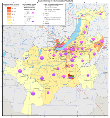
<p>The environment-protection infrastructure (EPI) is a component of ecological infrastructure and the most important sector of the current economic complex of the territory. The basic function of the EPI is to minimize the effect on the environment of deposited and utilized wastes (on the territory), discharges (into water bodies), production and consumer emissions (into the atmosphere), provided there is a developed selective (separate) collection of the secondary material resources. The EPI activity helps preserve a favorable environment for humans and use the territory’s resources in a rational manner. This map reflects only the EPI that deals with solid production and consumer wastes, with the latter often referred to as “municipal wastes” in the international practice.</p>
<p>The database includes the data of territorial offices of the Ministry of Natural Resources of Russia, the Russian governmental report on the state of Lake Baikal and measures for its protection (2013), Ministry of Nature, Environment and Tourism of Mongolia (2012), as well as project materials of regional development initiatives. It should be noted that the register of sites for storing (stockpiling or deposition) and burying of production and consumer wastes for individual regions is far from complete (based on  Form 2-TP (Wastes)).</p>
<p>In the Baikal catchment zone (in the lower level administrative districts of the Russian part and aimags in Mongolia), the annual volume of production and consumer waste reaches about 86 million tons. The majority of these wastes goes to the EPI facilities of production enterprises (sludge dumps, tailings ponds, mining waste piles, slag and ash dumps, etc.) and municipalities (predominantly waste dumps and landfills). The official statistics recorded over 600 sites for depositing waste. There is a waste recycling plant (WRP) in Ulan-Ude. There are plans to build three more WRPs (Irkutsk, Ulaanbaatar, and the Special Economic Zone “Baikal Harbor” in the Republic of Buryatia), a waste sorting plant in Chita (Zabaikalsky krai), and several waste collection facilities for processing waste from ships on Lake Baikal.</p>
<p>The total volume of production and consumer waste generation in the Baikal basin is growing annually. The leader is Zabaikalsky krai with almost 2/3 of all registered wastes in the Baikal basin. Irkutsk oblast is leading in terms of the speed of waste generation per unit of Gross Regional Product (tons/million rubles). In terms of the number of registered EPI facilities and their area, Mongolia tops the list, with Buryatia being the second, which corresponds to the territory they occupy in the Baikal basin. The average size of EPI facilities of municipalities and aimags is 4.3 hectares. The size of EPI facilities of Mongolian aimags (6.3 ha) exceeds this indicator by almost 1.5 times, while the size of such facilities in Irkutsk oblast exceeds the average by 1.3 times. There are plans to restart the selective (separate) collection of the utilized portion of generated consumer wastes in the future, which will significantly reduce the size of authorized waste dumps and landfills, as well as numerous unauthorized landfills of solid consumer wastes.</p>
<p>By the structure of economic activity, mining wastes and wastes generated by the thermal power sector make up the largest share in the total volume of generated waste (in Zabaikalsky krai, Irkutsk oblast, and Buryatia their share is over 90%). Wastes of mining companies weighing millions of tons, as well as construction wastes, slag, and ash are classified as Class V by their hazard impact on the environment (not dangerous or low-hazard wastes).</p>
<p> </p>
<p align="center">Reference:</p>
<p>Rosgeolfond. Siberian Branch. (2013). <i>On the state of Lake Baikal and measures for its protection in 2012: State report. </i>Irkutsk: Rosgeolfond. p 436.</p>]]></content:encoded>
    <dc:publisher>No publisher</dc:publisher>
    <dc:creator>Alexander Ayurzhanaev</dc:creator>
    <dc:rights></dc:rights>
    <dc:date>2014-10-14T05:55:00Z</dc:date>
    <dc:type>Page</dc:type>
  </item>


</rdf:RDF>