<?xml version="1.0" encoding="utf-8" ?>
<rdf:RDF xmlns:rdf="http://www.w3.org/1999/02/22-rdf-syntax-ns#" xmlns:dc="http://purl.org/dc/elements/1.1/" xmlns:syn="http://purl.org/rss/1.0/modules/syndication/" xmlns="http://purl.org/rss/1.0/">


<channel rdf:about="http://bic.iwlearn.org/search_rss">
  <title>Байкальский информационный центр</title>
  <link>http://bic.iwlearn.org</link>

  <description>
    
            These are the search results for the query, showing results 316 to 330.
        
  </description>


  <image rdf:resource="http://bic.iwlearn.org/logo.png"/>

  <items>
    <rdf:Seq>
      
        <rdf:li rdf:resource="http://bic.iwlearn.org/en/atlas/atlas/110-child-population-disability-map/child-population-disability-map"/>
      
      
        <rdf:li rdf:resource="http://bic.iwlearn.org/en/documents/state-of-the-environment-report-the-lake-baikal-basin-1/state-regulation-and-public-movement-of-environmental-protection-and-nature-management"/>
      
      
        <rdf:li rdf:resource="http://bic.iwlearn.org/en/documents/state-of-the-environment-report-the-lake-baikal-basin-1/ecological-conditions"/>
      
      
        <rdf:li rdf:resource="http://bic.iwlearn.org/en/documents/state-of-the-environment-report-the-lake-baikal-basin-1/socio-economic-conditions"/>
      
      
        <rdf:li rdf:resource="http://bic.iwlearn.org/en/documents/state-of-the-environment-report-the-lake-baikal-basin-1/natural-conditions"/>
      
      
        <rdf:li rdf:resource="http://bic.iwlearn.org/en/documents/state-of-the-environment-report-the-lake-baikal-basin-1/general-conditions-of-the-baikal-lake-basin"/>
      
      
        <rdf:li rdf:resource="http://bic.iwlearn.org/en/friends/centre-for-independent-social-research-and-education-russia-irkutsk-region"/>
      
      
        <rdf:li rdf:resource="http://bic.iwlearn.org/en/friends/center-for-study-and-conservation-of-darkhad-valley-ecosystem-mongolia"/>
      
      
        <rdf:li rdf:resource="http://bic.iwlearn.org/en/documents/documents/papers/Cartographic%20monitoring%20of%20transboundary%20socio-economic%20processes%20-rus.pdf"/>
      
      
        <rdf:li rdf:resource="http://bic.iwlearn.org/en/documents/documents/papers/Cartographic%20evaluation%20of%20natural%20flood%20risk%20in%20the%20Lake%20Baikal%20Basin%20-rus.pdf"/>
      
      
        <rdf:li rdf:resource="http://bic.iwlearn.org/en/friends/buryat-republic-departament-of-russian-geographical-society-russia-buryat-republic"/>
      
      
        <rdf:li rdf:resource="http://bic.iwlearn.org/en/friends/buryat-regional-branch-of-russian-public-organization-all-rusian-society-for-nature-conservation-russia-buryat-republic"/>
      
      
        <rdf:li rdf:resource="http://bic.iwlearn.org/en/atlas/atlas/138-bubble-the-gas-outlet-from-the-bottom-sediments-map/bubble-the-gas-outlet-from-the-bottom-sediments-map"/>
      
      
        <rdf:li rdf:resource="http://bic.iwlearn.org/en/atlas/atlas/126-bottom-contour-map/bottom-contour-map"/>
      
      
        <rdf:li rdf:resource="http://bic.iwlearn.org/en/documents/documents/complex-reports/bic-conception-for-mongolia-english"/>
      
    </rdf:Seq>
  </items>

</channel>


  <item rdf:about="http://bic.iwlearn.org/en/atlas/atlas/110-child-population-disability-map/child-population-disability-map">
    <title>Child population disability map</title>
    <link>http://bic.iwlearn.org/en/atlas/atlas/110-child-population-disability-map/child-population-disability-map</link>
    <description></description>
    <content:encoded xmlns:content="http://purl.org/rss/1.0/modules/content/"><![CDATA[<p><img class="image-inline" src="../../../resolveuid/7b407d27104245d988eb8434ba442e1f/@@images/image/preview" /></p>
<p><a href="http://bic.iwlearn.org/en/atlas/photos/copy_of__110_Childpopulationdisability.png" class="internal-link">Open full size</a></p>
<p align="center"><strong>Healthcare</strong><strong> </strong></p>
<p align="center"><strong> </strong></p>
<p>Harsh climatic conditions across the entire territory of the Baikal basin and the surface and ground water used for drinking and food purposes that do not meet the drinking water quality standards (first and foremost in Mongolia and Buryatia) coupled with atmospheric emissions from industrial facilities and motor vehicles (in some parts of the territory) are responsible for the state of human health influencing the organization of healthcare. The ecological situation becomes substantially worse during winter months, which is encouraged by the topography of the terrain. In Mongolia, the spring period is very hard time to bear, with sharp temperature differences, abrupt variations in atmospheric pressure, and frequent dust and magnetic storms.</p>
<p class="NormalWeb">The organizational pattern of healthcare in Russia and Mongolia has much in common. This is a result of the cooperation of the two countries in this sphere and the fact that medical education and healthcare in Mongolia are organized using Russian experience. Today, Mongolian medical facilities operate on the principles of the state-private partnership concurrent with the demonopolization of the state system of medical services. The country has a mandatory and voluntary medical insurance system, in which state-owned and private medical institutions take part. The country also has various health institutes and centers.</p>
<p class="a">The territory of the Baikal basin is experiencing a deficit of medical workers. As of 2012, the availability of physicians varied from 13.8 to 30.1 per 10,000 people in Russian districts and from 16.1 to 29.0 per 10,000 people in Mongolian aimags. The availability of nurses varies from 25.1 to 112.2 per 10,000 people in Russian districts and from 26.4 to 38.2 per 10,000 people in Mongolian aimags. In Ulan-Ude, these indicators have the values of 53.9 and 117.3, while in Ulaanbaatar – 44.1 and 41.2, respectively.</p>
<p>The ratio of doctors and nurses in the Russian part of the basin is between 1:2 to 1:4, while in the Mongolian part it does not exceed 1:2. The World Health Organization (WHO) recommends that this ratio should be 1:4. A narrowing of this indicator causes imbalances in the healthcare system thereby limiting possibilities for further development of the after-treatment, casework and rehabilitation services.</p>
<p>Target indicators of healthcare activity are the standard volume of medical care per inhabitant. Currently, there are plans to decrease the per capita volume of in-patient services and increase the per capita volume of the hospital-replacing care. Accordingly, the number of hospital beds available 27/7 will decrease, while the number of beds in day hospitals will grow. Overall, the available number of hospital beds complies with the calculated standards and meets the demand of the population for the in-patient medical aid.</p>
<p class="ConsPlusNormal">
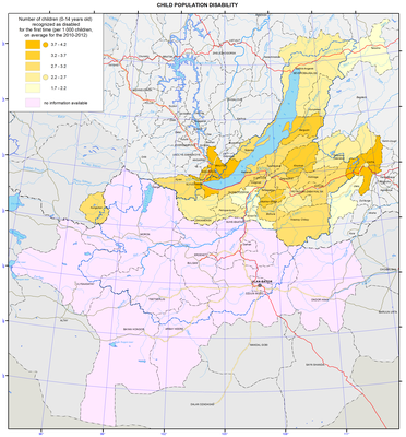
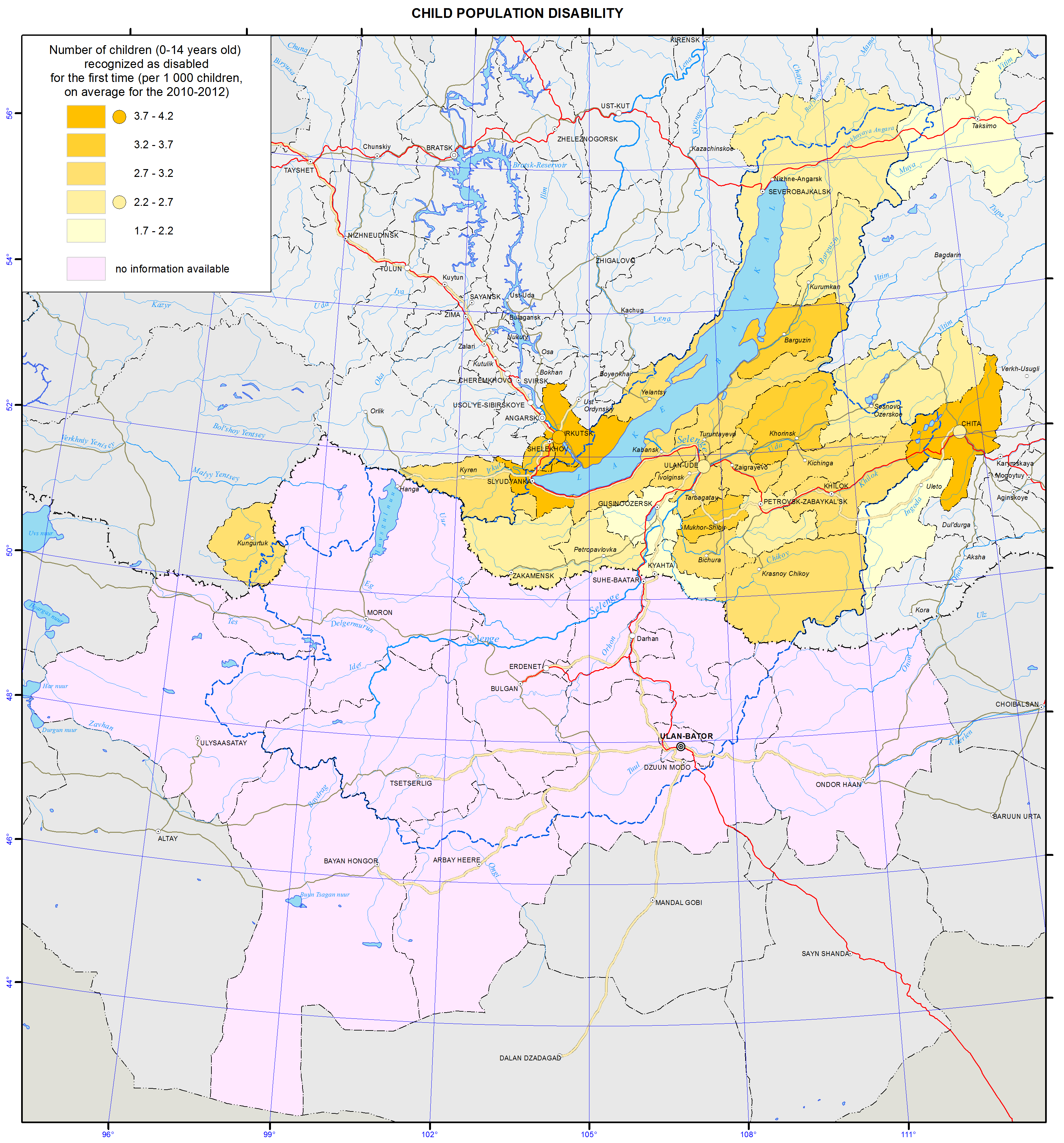
As of today, in Russia, there is an array of problems relating to the high level of illnesses and disability incidences among the population, and these indicators are continuously growing. Such a situation is the result of inadequate preventive measures. Another important contributing factor to this situation is the increase of the proportion of elderly population and the improved effectiveness of illness detection using new diagnostic methods in the process of the increased number of medical checkups.</p>
<p class="ConsPlusNormal">The leading illnesses in the structure of morbidity are respiratory illnesses, bloodstream, eye, and digestive and musculoskeletal system diseases, as well as traumas. For many years, circulatory system diseases, neoplasms, and injuries have been the main causes of mortality and disability among the population.</p>
<p class="a">A complex of anthropogenic environmental factors contributes to the growth of morbidity and disability rates among the population with the most important one being air pollution. According to the WHO, atmospheric air pollution is the cause of up to 23% of all illnesses. The amount of pollutant emissions in the atmosphere produced by static sources in different administrative divisions in the Baikal basin differs by more than a thousand times. The most polluted air in the Baikal basin is in the Selenginsky district of Buryatia.</p>
<p>The health of the population and further development of healthcare depend on ecological, social, and economic factors. These problems can be resolved only through comprehensive approaches to the improvement of the quality of life of the population.</p>
<p>The strategic goal of the healthcare systems of Russia and Mongolia is to build a system, which ensures the quality and accessibility of medical services, primarily first aid, and increases the efficiency of medical services, based on the improvement of territorial planning of healthcare. The volume, types, and quality of these services should correspond to the rate of morbidity, population requirements, and the latest achievements of medical science, based on perfecting the system of territorial planning of public health services.</p>]]></content:encoded>
    <dc:publisher>No publisher</dc:publisher>
    <dc:creator>Alexander Ayurzhanaev</dc:creator>
    <dc:rights></dc:rights>
    <dc:date>2014-10-14T02:55:00Z</dc:date>
    <dc:type>Page</dc:type>
  </item>


  <item rdf:about="http://bic.iwlearn.org/en/documents/state-of-the-environment-report-the-lake-baikal-basin-1/state-regulation-and-public-movement-of-environmental-protection-and-nature-management">
    <title>Chapter V. State regulation of nature management. environmental movement</title>
    <link>http://bic.iwlearn.org/en/documents/state-of-the-environment-report-the-lake-baikal-basin-1/state-regulation-and-public-movement-of-environmental-protection-and-nature-management</link>
    <description></description>
    
    <dc:publisher>No publisher</dc:publisher>
    <dc:creator>Dmitry Popov</dc:creator>
    <dc:rights></dc:rights>
    <dc:date>2014-03-21T10:55:00Z</dc:date>
    <dc:type>Folder</dc:type>
  </item>


  <item rdf:about="http://bic.iwlearn.org/en/documents/state-of-the-environment-report-the-lake-baikal-basin-1/ecological-conditions">
    <title>Chapter IV. Natural and anthropogenic changes in the environment</title>
    <link>http://bic.iwlearn.org/en/documents/state-of-the-environment-report-the-lake-baikal-basin-1/ecological-conditions</link>
    <description></description>
    
    <dc:publisher>No publisher</dc:publisher>
    <dc:creator>Dmitry Popov</dc:creator>
    <dc:rights></dc:rights>
    <dc:date>2014-03-21T10:55:00Z</dc:date>
    <dc:type>Folder</dc:type>
  </item>


  <item rdf:about="http://bic.iwlearn.org/en/documents/state-of-the-environment-report-the-lake-baikal-basin-1/socio-economic-conditions">
    <title>Chapter III.  Use of natural resources</title>
    <link>http://bic.iwlearn.org/en/documents/state-of-the-environment-report-the-lake-baikal-basin-1/socio-economic-conditions</link>
    <description></description>
    
    <dc:publisher>No publisher</dc:publisher>
    <dc:creator>Dmitry Popov</dc:creator>
    <dc:rights></dc:rights>
    <dc:date>2014-03-21T10:55:00Z</dc:date>
    <dc:type>Folder</dc:type>
  </item>


  <item rdf:about="http://bic.iwlearn.org/en/documents/state-of-the-environment-report-the-lake-baikal-basin-1/natural-conditions">
    <title>Chapter II. Conditions of natural environment</title>
    <link>http://bic.iwlearn.org/en/documents/state-of-the-environment-report-the-lake-baikal-basin-1/natural-conditions</link>
    <description></description>
    
    <dc:publisher>No publisher</dc:publisher>
    <dc:creator>Dmitry Popov</dc:creator>
    <dc:rights></dc:rights>
    <dc:date>2014-03-21T10:55:00Z</dc:date>
    <dc:type>Folder</dc:type>
  </item>


  <item rdf:about="http://bic.iwlearn.org/en/documents/state-of-the-environment-report-the-lake-baikal-basin-1/general-conditions-of-the-baikal-lake-basin">
    <title>Chapter I. General characteristics of lake Baikal basin  </title>
    <link>http://bic.iwlearn.org/en/documents/state-of-the-environment-report-the-lake-baikal-basin-1/general-conditions-of-the-baikal-lake-basin</link>
    <description></description>
    
    <dc:publisher>No publisher</dc:publisher>
    <dc:creator>Dmitry Popov</dc:creator>
    <dc:rights></dc:rights>
    <dc:date>2014-03-19T07:55:00Z</dc:date>
    <dc:type>Folder</dc:type>
  </item>


  <item rdf:about="http://bic.iwlearn.org/en/friends/centre-for-independent-social-research-and-education-russia-irkutsk-region">
    <title>Centre for independent social research and education (Russia, Irkutsk region)</title>
    <link>http://bic.iwlearn.org/en/friends/centre-for-independent-social-research-and-education-russia-irkutsk-region</link>
    <description></description>
    <content:encoded xmlns:content="http://purl.org/rss/1.0/modules/content/"><![CDATA[<p style="text-align: center; "><b>CENTRE FOR INDEPENDENT SOCIAL RESEARCH AND EDUCATION </b><b>(Irkutsk)</b></p>
<p style="text-align: center; "><img class="image-inline" src="../../resolveuid/474b6fd6b63b497f89a7ff7b80fa9979/@@images/image/preview" /></p>
<p style="text-align: center; "> </p>
<p><span style="text-decoration: underline;">Contact information:</span></p>
<p>Irkutsk, Lenina st., 6a</p>
<p>Tel. / Fax: 8 (3952) 33-37-21</p>
<p>E-mail: cnsio@list.ru</p>
<p>Website: http://www.irk-center.ru/</p>
<p><span style="text-decoration: underline;">Director:</span> Rozhansky Mikhail</p>
<p><span style="text-decoration: underline;">Year of establishment:</span> 2002.</p>
<p>It was then, with the support of the St. Petersburg Center for Independent Social Research succeeded in uniting into one organization a large research team that worked on the program «Teacher-researcher» and a two-year education and research program «Ethnopolitical situation in the Baikal region» (Irkutsk University with support from the Ford Foundation) .</p>
<p><span style="text-decoration: underline;">Main areas of work</span></p>
<p>Along with the research and educational activities of the Centre for Independent Social Research and Education conducts marketing and consulting work since the beginning of 2003. During this time, sold more than 50 research projects of different types and volume. Created an extensive database of methodological and other materials assembled a unique team of professional performers. All this allows us today as efficiently as possible to conduct market research.</p>
<p>The center works in projects «Expert» magazine and the Fund for Public Opinion Research.</p>
<p>Center - a research organization that enables constant internal quality assessment work and allows employees to constantly improve their skills and expand their knowledge.</p>
<p>We use quantitative research methods (such as the mass survey) and qualitative (in-depth interviews, focus group).</p>
<p><span style="text-decoration: underline;">Implementation of projects:</span></p>
<p>- International Conference of Young Researchers of Siberia «Siberia socialist soviet century in private memory», April 7-12, 2013, Irkutsk.</p>
<p>- International Conference of Young Researchers of Siberia «Siberia socialist-II. Soviet past today: practices, institutions, generation».May 25-30, 2014, Bratsk and Ust-Ilim.</p>
<p>- VI Baikal International School for Social Research «Historical Memory and generational analysis» (August 27 - September 2, 2013, Irkutsk).</p>
<p>- V Baikal International School for Social Research «Actors of social change. Humanities in public debates, social movements and social projects»юAugust 30 - September 5, 2012, Irkutsk, Olkhon Island.</p>]]></content:encoded>
    <dc:publisher>No publisher</dc:publisher>
    <dc:creator>Alexander Ayurzhanaev</dc:creator>
    <dc:rights></dc:rights>
    <dc:date>2015-02-06T06:45:54Z</dc:date>
    <dc:type>Page</dc:type>
  </item>


  <item rdf:about="http://bic.iwlearn.org/en/friends/center-for-study-and-conservation-of-darkhad-valley-ecosystem-mongolia">
    <title>Center for study and conservation of Darkhad valley ecosystem (Mongolia)</title>
    <link>http://bic.iwlearn.org/en/friends/center-for-study-and-conservation-of-darkhad-valley-ecosystem-mongolia</link>
    <description></description>
    <content:encoded xmlns:content="http://purl.org/rss/1.0/modules/content/"><![CDATA[<p align="center"><b>CENTER FOR STUDY AND CONSERVATION OF DARKHAD VALLEY ECOSYSTEM</b></p>
<p> </p>
<p><span style="text-decoration: underline;">Year of Establishment</span> 2007</p>
<p><span style="text-decoration: underline;">Contact details: </span>Ulaan Uul soum, Khuvsgul aimag, Mongolia</p>
<p>Unit 206, Block B of Mongolian University of Humanitarian</p>
<p>(976) 99799517, (976) 99772050</p>
<p>e-mail <a href="mailto:magsarjav_89@yahoo.com">magsarjav_89@yahoo.com</a></p>
<p><span style="text-decoration: underline;">Head of the organization</span> Magsarjav, E.</p>
<p><span style="text-decoration: underline;">Scope of the activities</span> Conduct research study, organize public awareness activities and other activities in line with the objective<span style="text-decoration: underline;"></span></p>
<p><span style="text-decoration: underline;">Mission </span>Study natural phenomenon, biodiversity resource of Darkhad depression, advocate results of research study, experience and knowledge sharing among national and international researches<span style="text-decoration: underline;"></span></p>
<p><span style="text-decoration: underline;">List of the environmental related projects implemented</span></p>
<p>-         Environmental campaign among school children against illegal mining</p>
<p>Supporting school clubs.</p>]]></content:encoded>
    <dc:publisher>No publisher</dc:publisher>
    <dc:creator>Alexander Ayurzhanaev</dc:creator>
    <dc:rights></dc:rights>
    <dc:date>2015-02-09T02:18:13Z</dc:date>
    <dc:type>Page</dc:type>
  </item>


  <item rdf:about="http://bic.iwlearn.org/en/documents/documents/papers/Cartographic%20monitoring%20of%20transboundary%20socio-economic%20processes%20-rus.pdf">
    <title>Cartographic monitoring of transboundary socio-economic processes (rus).</title>
    <link>http://bic.iwlearn.org/en/documents/documents/papers/Cartographic%20monitoring%20of%20transboundary%20socio-economic%20processes%20-rus.pdf</link>
    <description></description>
    
    <dc:publisher>No publisher</dc:publisher>
    <dc:creator>Alexander Ayurzhanaev</dc:creator>
    <dc:rights></dc:rights>
    <dc:date>2014-03-28T09:25:00Z</dc:date>
    <dc:type>File</dc:type>
  </item>


  <item rdf:about="http://bic.iwlearn.org/en/documents/documents/papers/Cartographic%20evaluation%20of%20natural%20flood%20risk%20in%20the%20Lake%20Baikal%20Basin%20-rus.pdf">
    <title>Cartographic evaluation of natural flood risk in the Lake Baikal Basin (rus).</title>
    <link>http://bic.iwlearn.org/en/documents/documents/papers/Cartographic%20evaluation%20of%20natural%20flood%20risk%20in%20the%20Lake%20Baikal%20Basin%20-rus.pdf</link>
    <description></description>
    
    <dc:publisher>No publisher</dc:publisher>
    <dc:creator>Alexander Ayurzhanaev</dc:creator>
    <dc:rights></dc:rights>
    <dc:date>2014-03-28T09:25:00Z</dc:date>
    <dc:type>File</dc:type>
  </item>


  <item rdf:about="http://bic.iwlearn.org/en/friends/buryat-republic-departament-of-russian-geographical-society-russia-buryat-republic">
    <title>Buryat republic departament of Russian geographical society (Russia, Republic of Buryatia)</title>
    <link>http://bic.iwlearn.org/en/friends/buryat-republic-departament-of-russian-geographical-society-russia-buryat-republic</link>
    <description></description>
    <content:encoded xmlns:content="http://purl.org/rss/1.0/modules/content/"><![CDATA[<p align="center"><strong>BURYAT REPUBLIC DEPARTAMENT OF RUSSIAN GEOGRAPHICAL SOCIETY (BRD RGS)</strong></p>
<p>670047, Republic of Buryatia, Ulan-Ude, Sakhyanovoy st. 8, of. 38</p>
<p>E-mail: baikalrgo@gmail.com</p>
<p>Website: buryatia.rgo.ru</p>
<p>Phone / fax: 8 (3012) 43-36-76</p>
<p><span style="text-decoration: underline;">Director:</span> Corresponding Member of the Russian Academy of Sciences, a member of the Federation Council Tulokhonov Arnold Kirillovich</p>
<p><span style="text-decoration: underline;">Scientific Secretary:</span> PhD (Geography) Batotsyrenov Eduard Ayurovich.</p>
<p> </p>
<p><span style="text-decoration: underline;">Year of </span><span style="text-decoration: underline;">establishment</span>: 13 July 1894 was created Troitskosavsk-Kyakhta Priamursky Department of the Imperial Russian Geographical Society (TKDRGS), which became the legal successor of the Buryat Branch of the Russian Geographical Society.</p>
<p>Goal of establishment: a collection and distribution of geographic information, promotion of geographical knowledge.</p>
<p>Number of members: 318 people.</p>
<p><span style="text-decoration: underline;">Main activities and implementation of projects</span></p>
<p><strong>2013:</strong></p>
<p>- «Trans-Eurasian flight» Leman - Baikal «, 2013-2015;</p>
<p>- Expedition «Following N.M. Przewalski (in honor of the 150th anniversary of the first expedition)», 5-18 August 2013</p>
<p>- The Summer geographical and ecological schools on the basis of international environmental education center «Istomino» (Nukutsky district of Irkutsk oblast', gymnasium №14 Ulan-Ude).</p>
<p><strong>Work under the RGS:</strong></p>
<p>- «Ecological Atlas of Russia» (co-executors);</p>
<p>- «Reexposition of the ak. V.A. ObruchevKyakhtinsky museum»;</p>
<p>- «The transformation of the natural environment Transbaikalia and adjacent areas: a retrospective analysis and present state» (Grant of the Russian Foundation for Basic Research -RGO).</p>
<p><strong>Support for olympiads and competitions:</strong></p>
<p>- «Baykalovedenie»</p>
<p>- «Geographic trip around the world»</p>
<p>The assets of the organization: scientific conferences, seminars, lectures, publication of monographs.</p>
<p>In May, planting of several hundreds of pine seedlings in Ivolginsky area;</p>
<p>in June, organizing geographical summer school at international environmental education center «Istomino»;</p>
<p>in July, organizing the round table discussion «Development of ecotourism: the initiatives and partnership business, society and the state» at Turka village;</p>
<p>in July and August, international research expedition «Trans-Eurasian flight Leman - Baikal». Three ultralight aircraft (deltaplanes) with the most modern equipment - hyperspectral (256 channels), RGB, infrared and near-infrared camera flight on the south part of Lake Baikal. Received tens of terabytes of images, which exhaustively filmed Selenga delta.</p>
<p>in August, at Kyakhtinsky museum started expedition of BRO RGS «By the Roads of N.M. Przewalskii». During two weeks the brigade followed the footsteps of the first, third and fourth Nikolai Mikhailovich Przewalskii expeditions through Mongolia to the border with China;</p>
<p style="text-align: center; "><img class="image-inline" src="../../resolveuid/daf07c18e75b40518c75db081dbe1bbf/@@images/image/preview" /></p>
<p align="center">Start of the expedition « By the Roads of N.M. Przewalskii » in Kyakhtinsky Museum, August 5, 2013</p>
<p>In September have been organized the third Baikal Ecoschool in Istomino. It was attended by students 8 «E» class (the letter «e» means ecology class) of 14th gymnasium Ulan-Ude. Within three days 29 students attended lectures of scientists from the Baikal Institute of Nature Management SB RAS, learned to make soil profiles and describe the forest, held cleaning-up of the shore of Lake Baikal, participated at the lesson of orienteering. In addition, students participated in the project GEF / UNDP project «Pilot Program sport fishing», under which the fish caught is returned to the pond alive and unharmed.</p>
<p>Work under the RGS grants and preservation of historical and cultural heritage of the RGS: create the database on the geographic discoveries history in Central Asia. In close cooperation with Kyakhtinsky Local History Museum stated the digitizing of archives of Troitskosavsk-Kyakhtinsky Branch RGS.</p>
<p><span style="text-decoration: underline;">Results, Lessons, and Prospects</span></p>
<p>Despite of the long period of neglect, in the past 3-4 years RGS Regional Office has revived its activities and in September 17-19, 2014 celebrated the 120-year anniversary.</p>
<p>In 2014 the international scientific-practical conference «Eastern Gate of Russia», dedicated to the 120th anniversary of the oldest in the province of scientific and educational society - Troitskosavsk-Kyakhtinsky Priamursky branch of the Imperial Russian Geographical Society have been prganized. Totally, from 1894 to 1961, 18 volumes Troitskosavsk-Kyakhtinsky Department of  RGS (TKDRGS) was published. Buryat department of RGS as the successor TKO RGS in collaboration with local history Kyakhtinsky Museum in order to celebrate the anniversary revived the tradition of publishing the studies of department members. Proceedings of the conference published in Volume XIX - «Proceedings of the Buryat regional department of the Russian Geographical Society.»</p>
<p>In the coming years, the department will continue work in the grant projects. In 2014, the new grant «History of Geographical Discoveries in Central Asia in the XVII-XIX centuries» started to implement.</p>
<p>One of the most important tasks of department is the creation of the Board of Trustees of BRD RGS. Thanks to him, it is planned to conduct grant competitions and support local initiatives. Another important goal is the creation Ulanbatar-Kyakhtinsky branch RGS. Academician G. Erdenzhav started the preparation of necessary documents in Ulan Bator and we hope that in the near future RGS will have an office in neighboring friendly country.</p>]]></content:encoded>
    <dc:publisher>No publisher</dc:publisher>
    <dc:creator>Alexander Ayurzhanaev</dc:creator>
    <dc:rights></dc:rights>
    <dc:date>2015-02-06T01:55:00Z</dc:date>
    <dc:type>Page</dc:type>
  </item>


  <item rdf:about="http://bic.iwlearn.org/en/friends/buryat-regional-branch-of-russian-public-organization-all-rusian-society-for-nature-conservation-russia-buryat-republic">
    <title>Buryat regional branch of russian public organization «All-rusian society for nature conservation» (Russia, Republic of Buryatia)</title>
    <link>http://bic.iwlearn.org/en/friends/buryat-regional-branch-of-russian-public-organization-all-rusian-society-for-nature-conservation-russia-buryat-republic</link>
    <description></description>
    <content:encoded xmlns:content="http://purl.org/rss/1.0/modules/content/"><![CDATA[<p style="text-align: center; "><strong>BURYAT REGIONAL BRANCH OF RUSSIAN PUBLIC ORGANIZATION «ALL-RUSIAN SOCIETY FOR NATURE CONSERVATION »</strong></p>
<p style="text-align: center; "><strong><img class="image-inline" src="../../resolveuid/15f33f61bb3c4ba491b7b4684f2c76bb/@@images/image/preview" /></strong></p>
<p>Tel .: 8 (301-2) 21-39-52, 21-84-15</p>
<p>Fax 8 (301-2) 21-48-99</p>
<p>E-mail: bator62@mail.ru, cerdeni@mail.ru</p>
<p><span style="text-decoration: underline;">Chairman</span>: Tsyrenov Bator Dashievich</p>
<p><span style="text-decoration: underline;">Vice-Chairman:</span> Tsydenov Erdeny Tsybikovich</p>
<p><span style="text-decoration: underline;">Executive Secretary</span>: Popkova Tatiana L'vovna</p>
<p><span style="text-decoration: underline;">Year of </span><span style="text-decoration: underline;">establishment</span>: 14 February 2008</p>
<p> </p>
<p><strong>All-Russian Society for Nature Conservation (ASNC)</strong> is all-Russian, social, cultural and educational environmental organization.</p>
<p><span style="text-decoration: underline;">ASNC Mission</span>: to maintain favorable environmental and social situation in the region and the country.</p>
<p><span style="text-decoration: underline;">The purposes of creation</span>: nature conservation, maintaining the diversity of flora and fauna; preservation and strengthening of health of community.</p>
<p><span style="text-decoration: underline;">Main activities:</span></p>
<p>- Assist public authorities and management in sustainable environmental development of the country;</p>
<p>- Environmental education, enlightenment and education of the population;</p>
<p>- Scientific and technical and practical environmental activities. Consulting activity of subjects of natural resources;</p>
<p>- Carrying out by organization and by accredited companies environmental monitoring of different areas;</p>
<p>- Introduction of modern high-precision technologies in order to implement an effective state environmental control.</p>
<p><strong>All-Russian Society for Nature Conservation (ASNC) celebrated 90-year anniversary at November 29, 2014.</strong></p>
<p>This old grassroots organization entered to the country's history as an authoritative public movement for safe and favorable environment. Despite the well-known difficulties of reforming the country, ASNC not only maintain but also strengthen their ranks and strengthen the scope of their meaningful participation in environmental activities.</p>
<p>At the present stage ASNC occupies a niche in the Russian environmental movement. This, above all, the personal involvement of its members in environmental education and public awareness in practical environmental actions, research and law-making, and development of club movement.</p>
<p>Statutory requirements ASNC is all possible assistance to state authorities in addressing environmental issues and state environmental programs (projects). This allow to bring in the nature protection the entire spectrum of civil society, and thus greatly improve work efficiency, especially in the regions.</p>
<p>ASNC has organizations in all regions of the Russian Federation and unites considerable potential scientists and specialists in various sectors of the economy.</p>
<p>All-Russian Society for Nature Conservation is member of the Coordinating Council of NGOs in Russia, a member of the «round table» of environmental organizations, the founder of Russian organization «Green Cross», Environment Congress, and the Russian environmental movement.</p>
<p>The Society carries out international cooperation, since 1960 it is a member of the International Union for Conservation of Nature (IUCN). In 1984 the Society was awarded by silver medal of United Nations Environment Programme (UNEP).</p>
<p>In Buryat Republic ASNC actually do not operate in several years. In April 2013 was renewed the membership of the organization, organized the election of the Council and Chairman of the Board, restored founding documents.</p>
<p>Implementation of projects</p>
<p>In 2013, Buryat department of ASNC:</p>
<p>- Participated in organizing and conducting the campaign of the «Green» Party during the elections to the People's Khural (regional parliament) of the Buryat Republic, involved to the work of the Public Environmental Council at the Prosecutor's Office of the Buryat Republic,</p>
<p>- Developed methodology for the construction of the mass primary organizations.</p>
<p>In 2014, Buryat department of ASNC:</p>
<p>- May 21, together with the Commission for the Environment, Environmental Management of the Public Chamber of the Buryat Republic, organized and conducted a round table discussion «Improvement of the environmental legislation in the area of Lake Baikal and the Baikal natural territory», where discussed the problem issues of improving environmental legislation in the area of the Lake Baikal and the Baikal area and decided organize the distribution in the media the open letter of inhabitants of Pribaikalsky. Kabansky, Barguzinsky, Severobaykalsky districts and Severobaykalsk town to the President of the Russian Federation V.V. Putin and organizing the collection of signatures for this letter;</p>
<p>- June 5, the organizer in the Buryat Republic the nationwide action «Let’s give to our rivers and lakes the pure shore», which annually held under Ministry of Natural Resources of Russia initiative (late May-early June), in the framework of the Federal Target Program «Development of water sector of the Russian Federation in 2012-2020» («Water of Russia»), supported by the All-Russian society for Nature Conservation;</p>
<p style="text-align: center; "><img class="image-inline" src="../../resolveuid/7129c6253a5543c6a4db7937ded7e6ae/@@images/image/preview" /></p>
<p align="center">All-Russian action «For our rivers and lakes - clean beaches»<span> </span></p>
<p>- August 21 organized a photo exhibition dedicated to the 90th anniversary of the All-Russian Society for Nature Conservation during the III International Forum «Dialogue Baikal. Prospects for economic development of the Baikal region» and the international scientific-practical conference «Development and distribution of productive forces of Buryat Republic»</p>
<p>- October 9, participated in the discussion of the Civil Forum «The role of environmental NGOs in the development of the economy and the preservation of the natural environment».</p>]]></content:encoded>
    <dc:publisher>No publisher</dc:publisher>
    <dc:creator>Alexander Ayurzhanaev</dc:creator>
    <dc:rights></dc:rights>
    <dc:date>2015-02-06T01:50:00Z</dc:date>
    <dc:type>Page</dc:type>
  </item>


  <item rdf:about="http://bic.iwlearn.org/en/atlas/atlas/138-bubble-the-gas-outlet-from-the-bottom-sediments-map/bubble-the-gas-outlet-from-the-bottom-sediments-map">
    <title>Bubble the gas outlet from the bottom sediments map</title>
    <link>http://bic.iwlearn.org/en/atlas/atlas/138-bubble-the-gas-outlet-from-the-bottom-sediments-map/bubble-the-gas-outlet-from-the-bottom-sediments-map</link>
    <description></description>
    <content:encoded xmlns:content="http://purl.org/rss/1.0/modules/content/"><![CDATA[<p><img class="image-inline" src="../../../../resolveuid/3db0cde9a6354efc8c79148fc3798900/@@images/image/preview" /></p>
<p><a href="http://bic.iwlearn.org/en/photos/138_Bubblethegasoutletfromthebottomsediments_Fixed.png" class="internal-link">Open full size</a></p>
<p align="center"><b>Gas bubble emissions from bottom sediments of Lake Baikal</b></p>
<p align="center"><b> </b></p>
<p>Methane emissions from bottom sediments in Lake Baikal have been known for a long time. Even the first travelers, who visited the lake in the 17<sup>th</sup> century, noticed gas emissions. Later gas emissions in Baikal were explored by the East Siberian Branch of the Russian Imperial Geographical Society. A review of the available materials on gas seeps in Baikal is presented in the publication [Granin and Granina, 2002]. A new stage of research on gas seeps in Baikal started after the discovery of gas hydrates [Kuzmin et al., 1998] and mud volcanoes at the bottom of the lake [Van Rensbergen et al., 2002] at the turn of the 20<sup>th</sup> century.</p>
<p>Gas seeps are found in oceans, seas and freshwater bodies. To study gas seeps hydroacoustic methods are used, as they enable an extensive search due to the strong backscattering of sound from the bubbles of floating-up gas. To locate and monitor the activity of gas plumes a digital record of acoustic signals of the echo sounders FURUNO, installed on the research vessels “G. Yu. Vereshchagin”, “Titov” and “Papanin”, was organized.</p>
<p>We subdivide gas seeps into shallow- and deepwater [Granin et al., 2010]. Deepwater gas seeps (red triangles on the map) are the ones that are located at depths greater than the depth of the gas hydrate stability (380 m); gas seeps, located at shallower depths (blue circles), belong to shallow-water gas seeps.</p>
<p>A substantial proportion of the shallow gas seeps are located near the Selenga river delta and on the Posolskaya bank. Multi-year monitoring of the activity of gas seeps made it possible to identify long-term and periodic gas shows. A maximum flare height of more than 1000 m was recorded in the area of ​​the mud volcano Malenky on June 23, 2011 from the RV “Titov”. According to the echo sounders data, the rise rates of gas bubbles reach 25 cm/s or more. In the area of plumes there is a near-bottom layer, where the temperature gradient is equal to the adiabatic one. This is indicative of a complete mixing of a significant layer of water as a result of the gas emissions [Granin et al.]</p>
<p>Using the acoustic sounding, a gas flow from bottom sediments was estimated. The estimation of the flow was made for several deepwater plumes. For different plumes the methane flow from the bottom sediments of Lake Baikal ranged from 14 to 216 tons per year. Comparing the result obtained with corresponding estimates for other water bodies, it may be said that the gas flow for the largest bottom gas seeps in Lake Baikal is corresponding to the flows in the Norwegian Sea and the Sea of ​​Okhotsk [Granin et al., 2-12].<b> </b></p>
<p align="center"><b> </b></p>
<p align="center">References</p>
<p>Granin, N. G., Granina, L. Z. (2002). Gas hydrates and gas venting in Lake Baikal. <i>Russ. Geol. Geophys, 43</i>(7), p 629-637.</p>
<p>Kuzmin, M. I., Kalmychkov, G. V., &amp; Gelety, V. F. (1998). The first finding of gas hydrates in the sedimentation mass of Lake Baikal. <i>Proceedings of the Russian Academy of Sciences, 362</i>(4). p 541-543.</p>
<p>Van Rensbergen, P., De Batist M., Klerkx J., Hus R., Poort J., Vanneste M., Granin N., Khlystov O., &amp; Krinitsky P. (2002). Sublacustrine mud volcanoes and methane seeps caused by dissociation of gas hydrates in Lake Baikal. <i>Geology, 30</i>(7). p 631-634.</p>
<p>Granin, N. G., Makarov, M. M., Kucher, K. M., &amp; Gnatovsky, R. Y. (2010). Gas seeps in Lake Baikal: Detection, distribution, and implications for water column mixing. <i>Geo-Marine Letters, 30</i>(3-4). p 399-409.</p>
<p>Granin N. G., Muyakshin, S. I., Makarov, M. M., Kucher, K. M., Aslamov, I. A., Granina, L. Z., &amp; Mizandrontsev, I. B. (2012). Estimation of methane flows from bottom sediments of Lake Baikal. <i>Geo-Marine Letters, 32</i>(5-6). p 427-436. DOI 10.1007/s00367-012-0299-6</p>]]></content:encoded>
    <dc:publisher>No publisher</dc:publisher>
    <dc:creator>Alexander Ayurzhanaev</dc:creator>
    <dc:rights></dc:rights>
    <dc:date>2014-10-15T04:50:00Z</dc:date>
    <dc:type>Page</dc:type>
  </item>


  <item rdf:about="http://bic.iwlearn.org/en/atlas/atlas/126-bottom-contour-map/bottom-contour-map">
    <title>Bottom contour map</title>
    <link>http://bic.iwlearn.org/en/atlas/atlas/126-bottom-contour-map/bottom-contour-map</link>
    <description></description>
    <content:encoded xmlns:content="http://purl.org/rss/1.0/modules/content/"><![CDATA[<p><img class="image-inline" src="../../../../resolveuid/ea99bdf4a99d4002b08ab8f2bd205eaa/@@images/image/preview" /></p>
<p><a href="http://bic.iwlearn.org/en/photos/copy2_of__126_Bottomcontour.png" class="internal-link">Open full size</a></p>
<p style="text-align: center; "><b>Bottom relief</b></p>
<p>The history of depth measurements in Lake Baikal goes back to 1798, when E. Kopylov and S. Smetanin, employees of a mine plant, carried out 28 measurements between the head of the Angara river and the mouth of the Selenga river. One of such measurements yielded a maximum depth of 1,238 m. Lake Baikal was immediately recognised as the second deepest lake in the world.</p>
<p>In the period of 1869-1876, B. Dybovsky and V. Godlevsky compiled a detailed and precise (for that time) map of Southern Baikal, which covered 11 cross-sections. Measurements of depth were carried out from the ice, which provided high accuracy [Dybovsky, Godlevsky, 1871, 1877].</p>
<p>In 1902 and 1908, the Pilot Chart of Lake Baikal and Atlas of Lake Baikal were published as a result of numerous hydrographic expeditions under the leadership of F. Drizhenko, in which the depths were shown in detail for the coastal areas of the lake.</p>
<p>In 1925, the USSR Academy of Sciences developed a long-term project under the supervision of G. Vereshchagin to study bathymetry of Lake Baikal. This initiative resulted in the organisation of Limnological Station, later reorganised into Limnological Institute. This project helped discover the deepest place in the lake and an underwater shallow ridge named the Akademichesky Ridge, which separates the northern basin from the central one. New bathymetric maps (scales 1:300,000 and 1:500,000) were compiled. They were demonstrated at the International Limnological Congress held in Rome in 1934.</p>
<p>In 1962, A. Rogozin and B. Lut compiled a new bathymetric map (scale 1:300,000) as a result of long-term bathymetric expeditions. Based on this map, the Central Department for Navigation and Oceanography of the Ministry of Defence of the USSR (CDNO) published maps  “Northern and Southern Areas of Lake Baikal”  in 1973 and 1974.</p>
<p>In the period of 1979-1985, CDNO carried out new systematic echo-sounding bathymetric measurements throughout the entire Lake Baikal. Traverses had a spacing of 100 and 250 m in the coastal waters and 1 km in the abyssal areas. As a result of these investigations, a four-sheet bathymetric map of Lake Baikal was published in 1992 (scale of 1:200,000). To date, this is the most reliable bathymetric map of Lake Baikal. However, it has some shortcomings:</p>
<ul>
<li>Bathymetry is based only on some available original data;</li>
<li>Bathymetry      is presented by the contours of isobaths that were taken manually;</li>
<li>Bathymetry is mainly represented by isobaths with a step of 100 m      up to a depth of 1,000 m and 500 m for depths exceeding 1,000 m;</li>
<li>Recent investigations showed that significant discrepancies can      exist between true depth values and echo-sounding measurements, which are      attributed to discrepancies between the real acoustic speed in Lake Baikal      and the calculated rate for the echo-sounder.</li>
</ul>
<p>In 1999, an international group of experts was organised to jointly compile a new, more precise bathymetric map of Lake Baikal. It was necessary to carry out more detailed recalculations of measurement values, which were used for maps in 1992, to digitise and adjust them to the real acoustic speed, to integrate them with the echo-sounding data obtained earlier, and to compile a new more complete computer map of Lake Baikal based on all available measurement data. This project was financially supported by INTAS (International Association for the Promotion of Cooperation with Scientists from the New Independent States of the Former Soviet Union).</p>
<p>The CD ROM is available with final results of this project. Coordinates of points are in a Mercator’s projection, WGS 1984 ellipsoid. The latitude for all generated maps is 53<sup>o</sup> 0’ 00’’ N.</p>
<p>New bathymetric data made it possible to obtain specified morphometric information on Lake Baikal and to present it in tables. Taking into account that the lake surface is at 455.5 m a.s.l. (Baltic System of Heights), the deepest point of Lake Baikal is situated at 1186.5 m below the sea level.</p>
<p class="a">The relief of the bottom of Lake Baikal is represented by isobaths with a step of 100 m. The lake consists of three basins: Northern basin – the most shallow one with a maximum depth of 904 m and an average depth of 598.4 m. Central basin is the deepest one. Its maximum depth is 1637 m, while the average depth is 856.7 m. Southern basin’s maximum depth is 1461 m with the average depth of 853.4 m. The existing Baikal depression is asymmetric: its northern and northwestern slopes are very steep, while the southern and southwestern slopes are more flat. Maximum depths are located at a distance of one third of the lake’s width from the steep northwestern slope. There is a shallow platform – a shelf - on the lake's northern and northwestern side, which is weakly developed. The shelf on the southern and southwestern coast is more pronounced.</p>
<p class="a">Measurement results demonstrated that in the place of the supposed maximum depth of 1741 m, according to G. Y. Vereschagin, the actual depth is less than 1600 m - 1593-1596 m. Based on the data derived from echo sounding, the deepest part of Central Baikal is located between Cape Izhimei and Otto-Khushun. In 1972, control measurements using the NEL-5 echo-sounder showed the depth of 1637 m [Lut, 1987].</p>
<p class="a">Numerous underwater works using Pisces, Mir-1, and Mir-2 submersibles offered an opportunity to visually examine morphologic and morphometric features of the underwater slopes and compare these data with the results of echo sounding. Northern and northwestern slope is sporadically covered with silt deposits with bed rock monoliths protruding between silty patches.</p>
<p class="a">The steepest part of the underwater slope is located on the northern side of the depression near Cape Kolokolny, about 40 km from the southern edge of the depression. The total steepness of the slope here reaches 60-65 degrees, however, its steepness is lower than the steepness on the Baikal side of Olkhon Island by 10-15 degrees [Lut, 1987]. The steepness of northern and northwestern slopes reaches 60-40 degrees. According to the Pisces XI expedition on September 22, 1991, negative slopes at the depth of more than 700 m were observed. The steepness of the southern and southeastern slope is five to six times lower.  The average slope of the whole lake is four degrees.                                                                                                                                                                                                                                                                                                                                                     <b><i></i></b></p>
<p align="center">References</p>
<p>Drizhenko, F. K. (1902). Pilot Chart of Lake Baikal.</p>
<p>Drizhenko, F. K. (1908). Atlas of Lake Baikal.</p>
<p>Dybovsky, B., Godlevsky, V. (1871). Report on depth measurements in Lake Baikal carried out in spring of 1871. <i>Bulletin of the East Siberian Department of the Imperial Russian Geographical Society, 2</i>(5). p 6-16.</p>
<p>Dybovsky, B., Godlevsky, V. (1877). Report on experiments in 1876 (Profiles of Lake Baikal in the appendix<i> Bulletin of the East Siberian Department of the Imperial Russian Geographical Society, 8</i>. p 115-135.</p>
<p>Lut, V. F. (1987). <i>Morphology and morphometry of the Baikal basin. The way of knowing Baikal.</i> Novosibirsk: Nauka. p 34-47.</p>
<p>Northern Area of Lake Baikal. Scale 1:300,000. (1973). Leningrad: GUNIO.</p>
<p>Southern Area of Lake Baikal. Scale 1:300,000. (1974). Leningrad: GUNIO.</p>
<p>Lake Baikal (4 sheets). Scale 1:200,000. (1991, 1992). Leningrad-St. P: GUNIO.</p>
<p>De Batist, M., Canals, M., Sherstyankin, P. P., Alekseev, S. P., and Teams (2002). The INTAS Project 99-1669, October 2002.</p>
<p><img class="image-inline" src="../../../../resolveuid/2a3e18c5c1c740c79edd980588808474/@@images/image/preview" /><img class="image-inline" src="../../../../resolveuid/23e939a5781f448f81c07101d0703962/@@images/image/preview" /></p>
<p><img class="image-inline" src="../../../../resolveuid/36964c3878ae4b3fae3fb1bf006b705b/@@images/image/preview" /></p>]]></content:encoded>
    <dc:publisher>No publisher</dc:publisher>
    <dc:creator>Alexander Ayurzhanaev</dc:creator>
    <dc:rights></dc:rights>
    <dc:date>2014-10-15T01:10:00Z</dc:date>
    <dc:type>Page</dc:type>
  </item>


  <item rdf:about="http://bic.iwlearn.org/en/documents/documents/complex-reports/bic-conception-for-mongolia-english">
    <title>BIC Conception for Mongolia (English)</title>
    <link>http://bic.iwlearn.org/en/documents/documents/complex-reports/bic-conception-for-mongolia-english</link>
    <description></description>
    
    <dc:publisher>No publisher</dc:publisher>
    <dc:creator>puntsagsurenchoimpog@yahoo.com</dc:creator>
    <dc:rights></dc:rights>
    <dc:date>2014-12-25T02:10:14Z</dc:date>
    <dc:type>File</dc:type>
  </item>


</rdf:RDF>
