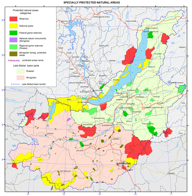
<?xml version="1.0" encoding="utf-8" ?>
<rdf:RDF xmlns:rdf="http://www.w3.org/1999/02/22-rdf-syntax-ns#" xmlns:dc="http://purl.org/dc/elements/1.1/" xmlns:syn="http://purl.org/rss/1.0/modules/syndication/" xmlns="http://purl.org/rss/1.0/">


<channel rdf:about="http://bic.iwlearn.org/search_rss">
  <title>Байкальский информационный центр</title>
  <link>http://bic.iwlearn.org</link>

  <description>
    
            These are the search results for the query, showing results 76 to 90.
        
  </description>


  <image rdf:resource="http://bic.iwlearn.org/logo.png"/>

  <items>
    <rdf:Seq>
      
        <rdf:li rdf:resource="http://bic.iwlearn.org/en/documents-1/state-of-the-environment-report-mongolia-2008-2010-english"/>
      
      
        <rdf:li rdf:resource="http://bic.iwlearn.org/en/documents/documents/state-reports/2013/state-of-the-environment-report-mongolia-2011-2012-mongolian"/>
      
      
        <rdf:li rdf:resource="http://bic.iwlearn.org/en/documents/documents/state-reports/2011/state-of-the-environment-report-mongolia-2008-2010-english-1"/>
      
      
        <rdf:li rdf:resource="http://bic.iwlearn.org/en/atlas/atlas/36-stability-of-soils-map/stability-of-soils-map"/>
      
      
        <rdf:li rdf:resource="http://bic.iwlearn.org/en/atlas/atlas/124-specially-protected-natural-areas-map/specially-protected-natural-areas-map"/>
      
      
        <rdf:li rdf:resource="http://bic.iwlearn.org/en/documents/documents/papers/Spatio-temporal%20dynamics%20of%20vegetation%20cover%20of%20arid%20and%20semiarid%20climatic%20zones%20in%20central%20Mongolia%20on%20the%20basis%20of%20time%20series%20NDVI%20and%20field%20studies%20-rus.pdf"/>
      
      
        <rdf:li rdf:resource="http://bic.iwlearn.org/en/documents/documents/papers/Spatial%20and%20temporal%20dynamics%20of%20the%20Baikal%20coastal%20line%20caused%20by%20control%20of%20the%20lake%20level%20regime%20-english.pdf"/>
      
      
        <rdf:li rdf:resource="http://bic.iwlearn.org/en/documents/documents/papers/some-results-of-applying-dpsir-analysis-for-ulaanbaatar-as-part-of-the-selenge-river-basin-integrated-water-management-system-english"/>
      
      
        <rdf:li rdf:resource="http://bic.iwlearn.org/en/atlas/atlas/35-soils-map/soils-map"/>
      
      
        <rdf:li rdf:resource="http://bic.iwlearn.org/en/atlas/atlas/37-soil-ecological-zoning-map/soil-ecological-zoning-map"/>
      
      
        <rdf:li rdf:resource="http://bic.iwlearn.org/en/atlas/atlas/91-soil-degradation-and-contamination-map/soil-degradation-and-contamination-map"/>
      
      
        <rdf:li rdf:resource="http://bic.iwlearn.org/en/atlas/atlas/128-slope-exposure-bottom-of-lake-baikal-map/slope-exposure-bottom-of-lake-baikal-map"/>
      
      
        <rdf:li rdf:resource="http://bic.iwlearn.org/en/news/the-baikal-project/ac801f1b626460c4a0bdaae7937098a7"/>
      
      
        <rdf:li rdf:resource="http://bic.iwlearn.org/en/news/the-baikal-project/1eea87bcabf590b0a14408e4f032e55e"/>
      
      
        <rdf:li rdf:resource="http://bic.iwlearn.org/en/friends/severobaikalsk-division-of-ngo-great-baikal-trail-russia-republic-of-buryatia"/>
      
    </rdf:Seq>
  </items>

</channel>


  <item rdf:about="http://bic.iwlearn.org/en/documents-1/state-of-the-environment-report-mongolia-2008-2010-english">
    <title>State of the Environment Report MONGOLIA- 2008-2010 -English</title>
    <link>http://bic.iwlearn.org/en/documents-1/state-of-the-environment-report-mongolia-2008-2010-english</link>
    <description></description>
    
    <dc:publisher>No publisher</dc:publisher>
    <dc:creator>Zorigma</dc:creator>
    <dc:rights></dc:rights>
    <dc:date>2015-03-03T07:41:50Z</dc:date>
    <dc:type>File</dc:type>
  </item>


  <item rdf:about="http://bic.iwlearn.org/en/documents/documents/state-reports/2013/state-of-the-environment-report-mongolia-2011-2012-mongolian">
    <title>State of the Environment Report MONGOLIA, 2011-2012 (Mongolian)</title>
    <link>http://bic.iwlearn.org/en/documents/documents/state-reports/2013/state-of-the-environment-report-mongolia-2011-2012-mongolian</link>
    <description></description>
    
    <dc:publisher>No publisher</dc:publisher>
    <dc:creator>puntsagsurenchoimpog@yahoo.com</dc:creator>
    <dc:rights></dc:rights>
    <dc:date>2014-12-25T06:06:10Z</dc:date>
    <dc:type>File</dc:type>
  </item>


  <item rdf:about="http://bic.iwlearn.org/en/documents/documents/state-reports/2011/state-of-the-environment-report-mongolia-2008-2010-english-1">
    <title>State of the Environment Report Mongolia, 2008-2010 (english)</title>
    <link>http://bic.iwlearn.org/en/documents/documents/state-reports/2011/state-of-the-environment-report-mongolia-2008-2010-english-1</link>
    <description></description>
    <content:encoded xmlns:content="http://purl.org/rss/1.0/modules/content/"><![CDATA[<p style="text-align: center; "><img class="image-inline" src="../../../../../resolveuid/11fad51eb3404c39865c475c67a44584/@@images/image/preview" /></p>
<p style="text-align: left; "><span>The Report of State of the Environment for 2008 to 2010 states that there are increasingly</span></p>
<div id="_mcePaste">negative impacts on the environment, for example: air pollution rates are increasing in the</div>
<div id="_mcePaste">capital and other big cities; desertification is increasing across Mongolia; rehabilitation work on</div>
<div id="_mcePaste">land damaged by mining activities are insufficient; the forest reserve area is decreasing; water</div>
<div id="_mcePaste">reserve management is insufficient; water pollution is increasing in some areas; and illegal use</div>
<div id="_mcePaste">of biodiversity is not decreasing.</div>
<div id="_mcePaste">To decelerate the negative changes in the state of the environment there is a need to improve</div>
<div id="_mcePaste">implementation of the legal framework and economy consistent with Mongolia’s ecology.</div>
<div id="_mcePaste">The primary mid-term strategies of the Government are the protection of native characteristics,</div>
<div id="_mcePaste">economic leverage for environmental protection, and expenditure on rehabilitation work</div>
<div id="_mcePaste">based on ecological and economic assessments.</div>
<div id="_mcePaste">I verify that the data and information contained in this report on current issues are the</div>
<div id="_mcePaste">results of real research into the current situation. It draws on the work of international and</div>
<div id="_mcePaste">non-governmental organisations, trainings, reports of research institutions, presentations, and</div>
<div id="_mcePaste">published information sets with scientific evidence.</div>
<div id="_mcePaste">If the words, terminology, report composition, or meanings used in this report do not fulfil</div>
<div id="_mcePaste">your needs please don’t hesitate to contact or write to us. Your suggestions are very valuable</div>
<div id="_mcePaste">to us and help to improve the quality of future reports.</div>
<p><a href="http://bic.iwlearn.org/en/documents-1/state-of-the-environment-report-mongolia-2008-2010-english" class="internal-link">Download file</a></p>]]></content:encoded>
    <dc:publisher>No publisher</dc:publisher>
    <dc:creator>Zorigma</dc:creator>
    <dc:rights></dc:rights>
    <dc:date>2015-03-03T07:45:24Z</dc:date>
    <dc:type>Page</dc:type>
  </item>


  <item rdf:about="http://bic.iwlearn.org/en/atlas/atlas/36-stability-of-soils-map/stability-of-soils-map">
    <title>Stability of soils map</title>
    <link>http://bic.iwlearn.org/en/atlas/atlas/36-stability-of-soils-map/stability-of-soils-map</link>
    <description></description>
    <content:encoded xmlns:content="http://purl.org/rss/1.0/modules/content/"><![CDATA[<p><img class="image-inline" src="../../../resolveuid/ceda1ca4ff4e474a8eab0d83c596e2ea/@@images/image/preview" /></p>
<p><a href="http://bic.iwlearn.org/en/atlas/photos/copy_of__36_Stabilityofsoils.png" class="internal-link">Open full size</a></p>
<p style="text-align: center; "><b><a href="http://bic.iwlearn.org/en/atlas/photos/copy_of__36_Stabilityofsoils.png" class="internal-link"></a><span>Soil stability</span></b></p>
<p align="center"><strong> </strong></p>
<p>A qualitative assessment of the soil stability (i.e. the resistance to external effects and the ability to restore the disturbed properties) was made with regard to the external and internal factors. In general, the stability decreases from low graded surfaces or gentle slopes with an increase in an altitude and steepness of slopes. In the same direction a change from loamy deposits to stony deposits with small thickness of the loose mass takes place, and heat supply changes for the worse. In total, four large subdivisions of soils were distinguished according to different degrees of stability: low, medium, medium and above medium, and moderate. Their characteristic is given in the legend to the map of the soil stability to the anthropogenic impact.</p>]]></content:encoded>
    <dc:publisher>No publisher</dc:publisher>
    <dc:creator>Alexander Ayurzhanaev</dc:creator>
    <dc:rights></dc:rights>
    <dc:date>2014-10-07T04:50:00Z</dc:date>
    <dc:type>Page</dc:type>
  </item>


  <item rdf:about="http://bic.iwlearn.org/en/atlas/atlas/124-specially-protected-natural-areas-map/specially-protected-natural-areas-map">
    <title>Specially protected natural areas map</title>
    <link>http://bic.iwlearn.org/en/atlas/atlas/124-specially-protected-natural-areas-map/specially-protected-natural-areas-map</link>
    <description></description>
    <content:encoded xmlns:content="http://purl.org/rss/1.0/modules/content/"><![CDATA[<p><img class="image-inline" src="../../../../resolveuid/b4c32351a3474621b3176dc8d5e0a7a2/@@images/image/preview" /></p>
<p><a href="http://bic.iwlearn.org/en/photos/copy2_of__124_Speciallyprotectednaturalareas.png" class="internal-link">Open full size</a></p>
<p align="center"><strong>Protected areas</strong></p>
<p>The Baikal basin is a unique region with a high biotic and landscape diversity. Specially protected areas ensure the protection of the ecosystems of the basin.</p>
<p>The importance of the principle of territorial nature protection is shown by the history of creation of protected natural territories (PNT). The first protected area in the Baikal basin – near the Bogd mountain range – was created in 1778, which is documented in the Mongolian written sources. Barguzinsky Reserve, founded in 1916, became the first of the currently operating Russian state reserves. The international significance of PNTs in the Baikal basin is underlined by the inscription of Lake Baikal on the UNESCO World Heritage list, as well as by the inclusion of four PNTs of the basin into the network of natural biosphere reserves run by the UNESCO program “Man and Biosphere” (MAB). In the recent years, determining factors of environmental policy included the implementation of the concept of sustainable development and Convention on Biological Diversity and other international environmental conventions ratified by Russia, as well as the compliance with the requirements concerning the ecosystem of Lake Baikal as a World Heritage Site.</p>
<p>A special federal law "On the Protection of Lake Baikal" was passed by Russia to preserve the World Heritage Site. This law established two ecological zones – central and buffer zones – within the Russian part of the Baikal basin, which, in turn, is part of the Baikal Natural Territory (BNT). In order to determine the nature protection regime in each of the category of PNTs in Russia and Mongolia, quite similar laws were passed in both countries including the Russian federal law “On Specially Protected Areas” (dated March 14, 1995) and national law of Mongolia “On Specially Protected Areas” (dated November 15, 1994, entered into force on April 1, 1995) [Mongolian…, 1996]. Due to the differences in the definition, we use the general term “Protected Natural Territory” (PNT).</p>
<p>It should be noted that a significant number of PNTs are divided by the basin’s borders. Nevertheless, they are also discussed in this Atlas.</p>
<p>
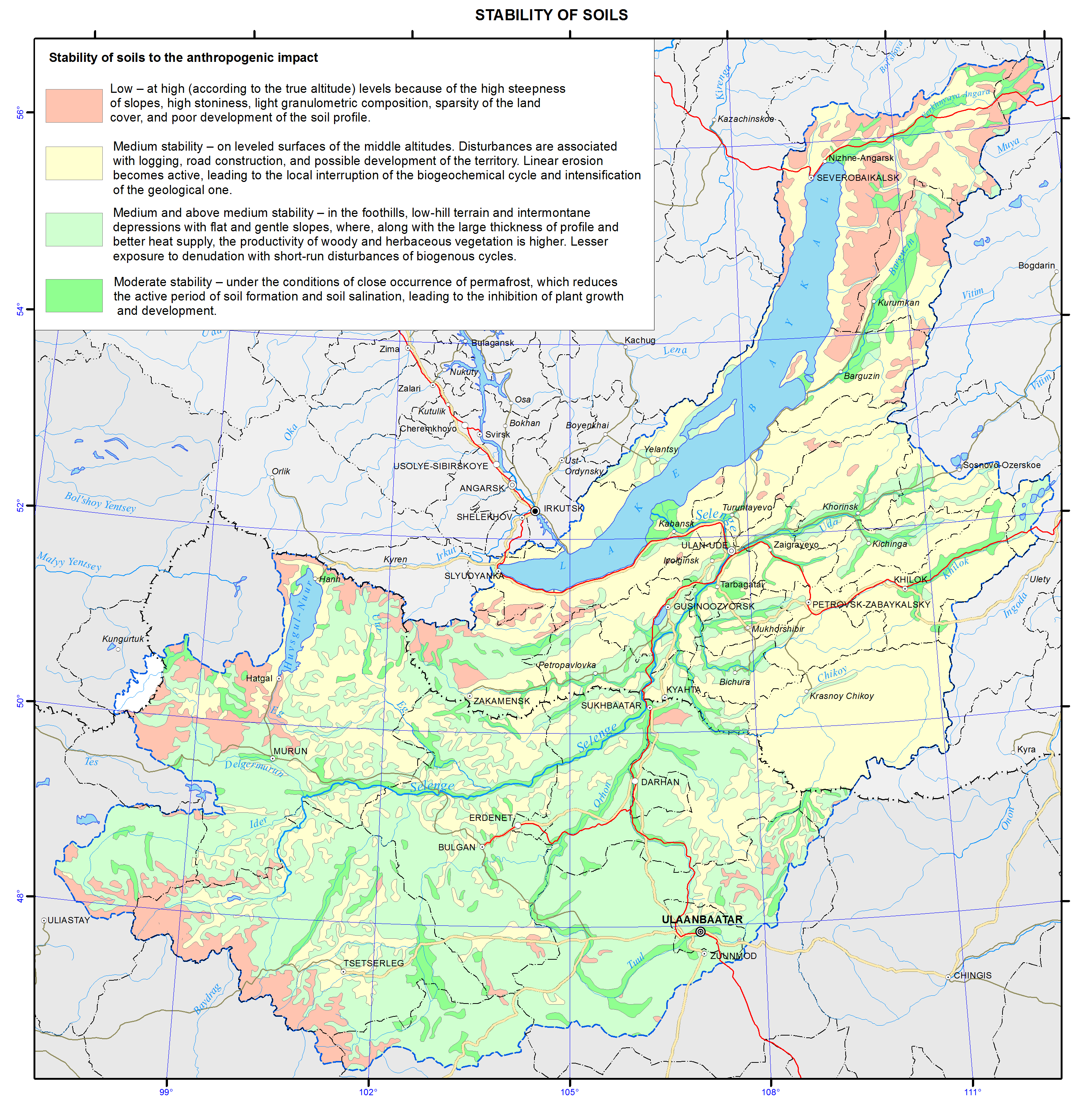
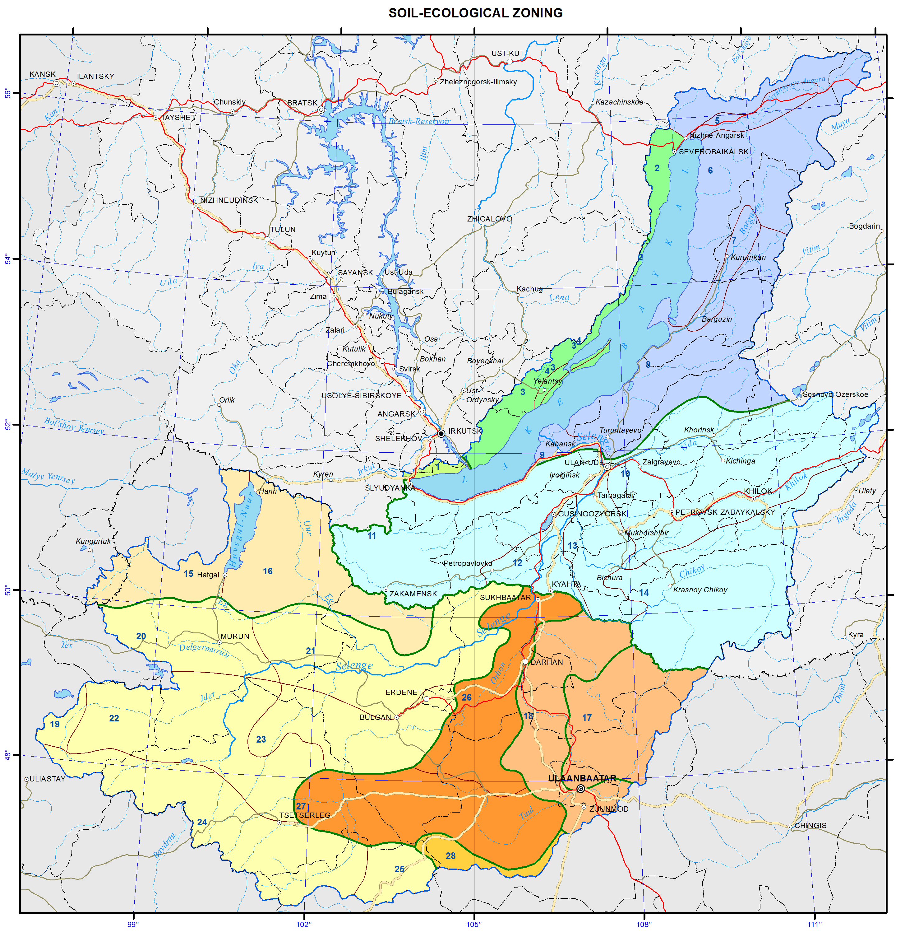
The PNTs within the basin are unevenly distributed [Savenkova, 2001, 2002]. The Irkutsk part of the basin is almost completely covered by the reserve regime (Pribaikalsky National Park, Baikal-Lena Reserve, Kochergatsky wildlife refuge) and represents an almost uninterrupted protected belt along the western shore of the lake. In Buryatia, the largest protected areas are located near Lake Baikal, while the rest represent only small-sized sanctuaries. In the Zabaikalsky part of the basin, PNTs are small, but they help protect the environment at the sources of key rivers. In the Mongolian part of the basin, PNTs are distributed along the basin’s boundary. Their number in the center of the basin is small. A small national park Tuzhiyn Nars can be mentioned among them. Thus, the ecosystems in the nearest surroundings of Lake Baikal are sufficiently protected, although the PNT distribution on the rest of the basin and the protection of the lake’s water area are not always optimal.</p>
<p>
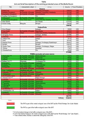
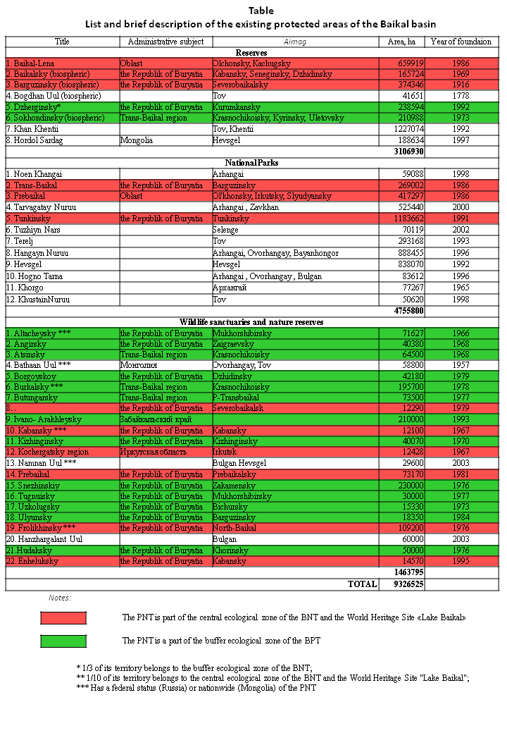
As of 2009, there are 46 PNTs of the main categories (see table) with a total area of 10442,171 thousand hectares within the Baikal basin. They include 10 reserves (incl. four biosphere reserves), 13 national parks, 23 wildlife refuges and sanctuaries. Moreover, in the Russian part of the basin, there are the so-called recreational areas, which are basically PNTs under district jurisdiction. In the Mongolian part of the basin, there are PNTs under aimag jurisdiction [Mongolia’s Wild Heritage…, 1996; Mongolia’s tentative…, 1999; Savenkova, Erdentsetseg, 2000, 2002; Oyungerel, 2009]. The map also shows four National Natural Monuments of Mongolia: Khuisiin Naiman Nuur, Uran Togoo-Tulga Uul, Bulgan Uul, and Dayan Derkhi.</p>
<p><img class="image-inline" src="../../../../resolveuid/774c005a6a094dffa18ec68a945bea49/@@images/image/preview" /></p>
<p><a href="http://bic.iwlearn.org/en/photos/copy_of__124_Table.png" class="internal-link">Open full size</a></p>
<p>There are plans to create 20 new PNTs of different categories in the Baikal basin.</p>
<p>In the Russian part these will include the “Selenga Delta” (Buryatia) and “Ikh Tayrisin” (Tuva) reserves, national parks "Chikoysky" (Zabaikalsky krai) and "Onotsky" (Irkutsk oblast), wildlife sanctuaries “Verhneulkansky” (Buryatia/Irkutsk oblast), "Khila" (Buryatia/Zabaikalsky krai), "Malkhansky" (Zabaikalsky krai), "Talovsky Lakes" (Irkutsk oblast), as well as the most numerous type of PNT – natural parks "Arey", "Yamarovka" (Zabaikalsky krai), "Utulik - Babkha", "Chersky Peak", "Warm Lakes" (Irkutsk oblast), "Upper Angara", "Kurkulinsky", "Mezhdurechye", "Posolsky Sor"," Slyudyanskiye Lakes", "Tagley", "Khakusy", "Yarki" (Buryatia) [Kalikhman, 2007].</p>
<p>In the Mongolian part of the basin, 11 territories will become new PNTs, including "Burengiyn Nuruu" reserve and nature reserves "Arkhan Buural-Badaryn Nuruu", "Bohloo-Chagtayn Nuruu", "Ikh Tunel-Emged Ovgod", "Tovhonhaan uul", "TerhenTsagaan uul", "Khalkhan bulnai" [Kalikhman, 2011; Special Protected Areas…, 2000].</p>
<p>Moreover, there are plans to organize five transboundary PNTs in the basin: "The Amur Source ", "Khentei – Chikoyskoye Highlands", "Selenga", "From Khovsgol to Baikal", "Delger - Muren" [Savenkova, 2001; Oyungerel, Savenkova, 2004]. A relative similarity in the legislature concerning the PNTs in Russia and Mongolia helps coordinate their activities, as well as the general nature protection efforts on neighboring territories. It can be proved by the already operating transboundary Russian-Mongolian PNTs outside the Baikal basin: the trilateral cluster transboundary reserve "Dauria", which includes the Russian reserve "Daursky" (Zabaikalsky krai), Mongolian reserve "Mongol Daguur", and Chinese reserve "Dalainor", has been working since 1994. A cluster transboundary World Heritage Site "The Uvs Nuur Basin" was founded in 2003. It consists of 12 different areas, five of which are in Mongolia and seven – in the Republic of Tuva, Russia [Kalikhman, 2012].</p>
<p>In general, it is possible to conclude that the currently existing system of the PNTs in the Baikal basin does not fully cover the region’s ecosystems and is unevenly distributed. In this regard, an increase in the number and size of PNTs is expected in order to improve the effectiveness of conservation measures.</p>
<p align="center"> </p>
<p align="center">References</p>
<p>Kalikhman, T. P. (2007). Specially protected natural areas within the boundaries of the Baikal Natural Territory. <i>Bulletin of the Russian Academy of Sciences: Geography, 3</i>, p 75-86.</p>
<p>Kalikhman, T. P.  (2011). <i>Territorial nature protection in the Baikal region</i>. Irkutsk: IG SB RAS Publishing. p 322.</p>
<p>Savenkova, T. P. (2001). <i>Protected areas of the Baikal basin</i>. Irkutsk: IG SB RAS Publishing. p 186.</p>
<p>Savenkova, T. P. (2002). <i>Atlas o</i>f p<i>rotected areas of the Baikal basin</i>. Irkutsk: p 96.</p>
<p>Savenkova, T. P., Erdenetsetseg, D. (2000). Development of a network of protected areas within the Baikal basin in Mongolia. <i>Geography and Natural Resources, 2</i>. p 131-138.</p>
<p>Savenkova, T. P., Erdenetsetseg, D. (2002). Protected areas of the Baikal Natural Territory. <i>Gazarzuyn Asuudluud</i>, 2. p 45-53.</p>
<p>Kalikhman, T. P.  (2012). The Nature Conservation of Baikal Region: Special Natural Protected Areas System in Three Environmental Models. In J. Tiefenbacher (Ed.,), <i>Perspectives on nature conservation: Patterns, pressures and prospects</i>. Rijeka, Croatia: InTech Open Access Publisher. p 199-222.</p>
<p>Mongolian Environmental Laws. (1996). Ulaanbaatar. p 152.</p>
<p>UNESCO Beijing office, Ministry of Education of Mongolia. (1999). Mongolia’s tentative list of cultural and natural heritage.  p 54.</p>
<p>Finch, C. (1996). <i>Mongolia’s wild heritage: Biological diversity, protected areas, and conservation in the land of Chingis Khaan</i>. Boulder, CO: Avery press. p 42.</p>
<p>Оyungerel, B. (2009). Tusgai khamgaalaltai gazar nutag. Scale 1 : 5,000,000. <i>Mongol ulsyn undesniy atlas, II khevlel</i>. Ulaanbaatar. p 156-157.</p>
<p>Special Protected Areas of Mongolia. (2000). Ulaanbaatar. p 105.</p>]]></content:encoded>
    <dc:publisher>No publisher</dc:publisher>
    <dc:creator>Alexander Ayurzhanaev</dc:creator>
    <dc:rights></dc:rights>
    <dc:date>2014-10-14T08:25:00Z</dc:date>
    <dc:type>Page</dc:type>
  </item>


  <item rdf:about="http://bic.iwlearn.org/en/documents/documents/papers/Spatio-temporal%20dynamics%20of%20vegetation%20cover%20of%20arid%20and%20semiarid%20climatic%20zones%20in%20central%20Mongolia%20on%20the%20basis%20of%20time%20series%20NDVI%20and%20field%20studies%20-rus.pdf">
    <title>Spatio-temporal dynamics of vegetation cover of arid and semiarid climatic zones in central Mongolia on the basis of time series NDVI and field studies (rus).</title>
    <link>http://bic.iwlearn.org/en/documents/documents/papers/Spatio-temporal%20dynamics%20of%20vegetation%20cover%20of%20arid%20and%20semiarid%20climatic%20zones%20in%20central%20Mongolia%20on%20the%20basis%20of%20time%20series%20NDVI%20and%20field%20studies%20-rus.pdf</link>
    <description></description>
    
    <dc:publisher>No publisher</dc:publisher>
    <dc:creator>Alexander Ayurzhanaev</dc:creator>
    <dc:rights></dc:rights>
    <dc:date>2014-04-11T06:20:00Z</dc:date>
    <dc:type>File</dc:type>
  </item>


  <item rdf:about="http://bic.iwlearn.org/en/documents/documents/papers/Spatial%20and%20temporal%20dynamics%20of%20the%20Baikal%20coastal%20line%20caused%20by%20control%20of%20the%20lake%20level%20regime%20-english.pdf">
    <title>Spatial and temporal dynamics of the Baikal coastal line caused by control of the lake level regime (english).</title>
    <link>http://bic.iwlearn.org/en/documents/documents/papers/Spatial%20and%20temporal%20dynamics%20of%20the%20Baikal%20coastal%20line%20caused%20by%20control%20of%20the%20lake%20level%20regime%20-english.pdf</link>
    <description></description>
    
    <dc:publisher>No publisher</dc:publisher>
    <dc:creator>Alexander Ayurzhanaev</dc:creator>
    <dc:rights></dc:rights>
    <dc:date>2014-04-11T06:20:00Z</dc:date>
    <dc:type>File</dc:type>
  </item>


  <item rdf:about="http://bic.iwlearn.org/en/documents/documents/papers/some-results-of-applying-dpsir-analysis-for-ulaanbaatar-as-part-of-the-selenge-river-basin-integrated-water-management-system-english">
    <title>Some results of applying dpsir analysis for Ulaanbaatar as part of the Selenge River Basin integrated water management system (English</title>
    <link>http://bic.iwlearn.org/en/documents/documents/papers/some-results-of-applying-dpsir-analysis-for-ulaanbaatar-as-part-of-the-selenge-river-basin-integrated-water-management-system-english</link>
    <description></description>
    
    <dc:publisher>No publisher</dc:publisher>
    <dc:creator>puntsagsurenchoimpog@yahoo.com</dc:creator>
    <dc:rights></dc:rights>
    <dc:date>2014-12-26T08:11:45Z</dc:date>
    <dc:type>File</dc:type>
  </item>


  <item rdf:about="http://bic.iwlearn.org/en/atlas/atlas/35-soils-map/soils-map">
    <title>Soils map</title>
    <link>http://bic.iwlearn.org/en/atlas/atlas/35-soils-map/soils-map</link>
    <description></description>
    <content:encoded xmlns:content="http://purl.org/rss/1.0/modules/content/"><![CDATA[<p><img class="image-inline" src="../../../resolveuid/3ba30bb6ade8473c90467fcbff108b20/@@images/image/preview" /></p>
<p><a href="http://bic.iwlearn.org/en/atlas/photos/copy_of__35_Soils.png" class="internal-link">Open full size</a></p>
<p><img class="image-inline" src="../../../../resolveuid/64331fca7f0746a2b5e94e77bc3d82d5/@@images/image/preview" /></p>
<p><a href="http://bic.iwlearn.org/en/photos/copy_of__35_Legend1.png" class="internal-link">Open full size</a></p>
<p><img class="image-inline" src="../../../../resolveuid/4834bd689a214af680fc5e260a4a4455/@@images/image/preview" /></p>
<p><a href="http://bic.iwlearn.org/en/photos/copy_of__35_Legend2.png" class="internal-link">Open full size</a></p>
<p align="center"><strong>Soils</strong></p>
<p class="normalnavy">Soil associations are presented in the contours on the map. Combinations of soils, united in a contour, are associated with the altitudinal and expositional differentiation, and are determined by the character of mesorelief (combinations) and microrelief (complexes), and by the heterogeneity of the soil-forming material (mosaic). The predominant soil is the first in the legend, followed by accompanying and occurring soils. Most soils are distinguished at the type level, rarely at the subtype level.</p>
<p class="normalnavy">The great extension of the territory of the Baikal basin from south to north determines latitudinal variations of the thermal factor and the associated vegetation and soil cover. In addition to these basic regular patterns, the influence of exposure and meridional arid mountain zonality is manifested here. The role of permafrost and heterogeneity of parent rocks, complicated and insufficiently clear evolution of landscapes in the past, and their changing as a result of the human impact are essential.</p>
<p class="normalnavy">Within the mountain taiga, independent contours are distinguished in the south-western and north-eastern parts of Cisbaikalia. They are represented by combinations of soils with the eluvial-illuvial and undifferentiated profile. The Baikalsky Ridge and the North-Baikal Highland are dominated by podzols and podburs, involving peat-podburs and sod-podzols. They are characterized by a thin profile, which averages 30 cm in podzols of the highland, while in the mountains of Cisbaikalia it is about 40 cm. Thickness of the profile of podburs, which can be regarded as being in the early stage of soil formation, is even less.</p>
<p class="normalnavy">Soils of piedmont dry steppes of Cisbaikalia are common in the Priolkhonie region and on Olkhon Island. Formation of dry steppe landscapes with chestnut soils is due to the arid mountain zonality (location in the rain shadow). The lack of atmospheric moistening is compounded here by a high water penetration capacity of woody-loamy soils. The territory is similar to that of the dry steppe of Kazakhstan in the nature of moistening, and to the middle taiga of Yakutia in heat supply. A consequence of the extreme soil-climatic conditions is a low biological productivity. Agroecosystems here are in a state of crisis; the vegetation and soil cover undergoes degradation.</p>
<p>In the high-mountain part of the Khamar-Daban, Muisky, Verkhne-Angarsky and Barguzinsky ridges the basic soils are petrozems, peat-lithozems, and coarse humus lithozems. Coarse humus, humic and humic-dark-humus soils are formed under the sub-alpine meadows. On the northern slopes, in relatively low relief elements, and in areas composed of parent rocks of heavier particle-size distribution, gley podburs are formed.</p>
<p>Cryo-lithozems, petrozems and cryo-carbo-lithozems accompany nival dissected landscapes of the Khangai region of Mongolia. Cryozems (coarse humus) and peat-cryozems are developed in the sub-goletz altitudinal belt, locating in a relatively narrow band near the forest line. In soils of taiga massifs permafrost areas are of frequent occurrence; moreover, seasonal frost is longstanding, and cryoturbation phenomena and solifluction are usual.</p>
<p>The structure of the soil cover of the mountain-taiga zone of Transbaikalia is heterogeneous and is largely associated with the manifestation of vertical zonality, slope exposure, and permafrost. The main soil background is comprised of podburs, podzols, sod-podzols, sod-podburs, gray-humus, humic, humic-dark-humus soils and coarse humus burozems. The main background of the soil cover of taiga territories of Mongolia includes cryozems, podburs and dark-humus soils. Soils of podzolic type are rare here. In the upper part of the taiga belt, cryozems and podburs are formed; higher there are peat-lithozems. In mountainous taiga there occur steppe "islands" with chernozem-like soils. They can be found on steep parts of the southern slopes, facing the broad areas of intermontane depressions.</p>
<p>The natural-climatic zone of forest-steppe is dominated by gray metamorphic soils, which are formed on the foothill areas of depressions and on the northern slopes of hills inside intermontane lows or at the bottom part of the forested slopes of ridges, facing the steppe depressions. These soils occupy the largest areas in the forest-steppe of the southern part of the Trans-Baikal middle mountains. In the forest-steppe landscape belt of Mongolia of light-coniferous and mixed subshrub and herbaceous facies there occur dark-humus metamorphosed soils, located mainly along the southern slopes of ridges and hills. Gray humus soils formed under woody communities with forbs on carbonate rocks. This combination of soils, characteristic of different environmental conditions, is the main feature of the soil cover at the junction of taiga and steppe.</p>
<p>In steppe landscapes of Transbaikalia the main background of the soil cover is comprised of chernozems. They are formed under meadow and true steppes. The main massifs of these soils are located in the Tugnui-Sukhara basin: on the Tugnuisky ridge and on the southern slopes of the Zagansky ridge, on the northern slopes of the Kudarinskaya range and the Small Khamar-Daban, Monostoisky, and Borgoisky ridges. In the more northern part of the territory, chernozems are formed in individual spots on the north-western slopes of the Unegeteisky ridge and along the Uda and Itantsa river valleys.</p>
<p>The soil cover of dry steppe is dominated by chestnut soils. They occupy vast tracts in the Udinskaya, Priselenginskaya, and Borgoiskaya steppes, and wide gently sloping terraces in the valleys of large rivers; they are common on the southern slopes of the ridges. On the watersheds of high ridges there occur soils of the lithozem group. Humus psammozems are formed on aeolian sand deposits of the dry steppe zone, especially in the Selenga-Chikoy and Chikoy-Khilok interfluves, and on pine-forest sands.</p>
<p>Soils of the river valleys of Cisbaikalia and Transbaikalia are represented mainly by alluvial humic-gley, peat-gley, dark-humus, gray-humus, and dark-humus quasi-gley soils. In the structure of the soil cover of the floodplains of the upper and middle reaches of the rivers stratified alluvial soils are of frequent occurrence. In the steppe and especially in the dry steppe zones of Transbaikalia solonchaks and less frequently solonetzic soils are formed in the river floodplains. They occupy mostly lacustrine depressions and lower parts of gentle slopes, generally adjacent to the river floodplains, where there is a zone of accumulation of waters of the valley runoff enriched with soluble salts or a discharge of mineralized groundwaters. The most common types of salinization of solonchaks and solonetzic soils are sulfate-soda, soda-sulfate, sulfate, and chloride-sulphate. Large massifs of saline soils are widespread in the Borgoiskaya steppe and lacustrine lows of Lakes Verkhnee Beloe and Nizhnee Beloe. Their proportion in the Ivolginskaya depression is quite substantial. Solonetzic soils and solonchaks also occur in lacustrine depressions of the Bichursky district and the Tugnuiskaya steppe. In the Selenga river delta, in the Barguzin river valley, and in some other regions relatively large massifs are covered with bogs, where mainly peat eutrophic and peat eutrophic gley soils develop.</p>
<p>Soils of waterlogged meadows and lacustrine-boggy complexes of Mongolia are widespread in the near-shore zone of Lakes Khovsgol and Doot-Nur, in the Dzhargalant-Gol and Mungaral-Gol interfluve, in the northern and southern part of the Darkhatskaya depression, and along river valleys. Alluvial dark-humus soils are formed in river floodplains on elevated areas, in deltas, and on alluvial fans of temporary streams. Alluvial humic gley soils are formed under the conditions of additional inflow of moisture. In elevated locations of the riverbed floodplain of mountain rivers on sandy-gravel deposits gray-humus alluvial and stratified soils were formed. Alluvial peat-gley (peat-mineral) soils are formed in relatively low locations of river floodplains with the conditions of long-term surface and subsurface moistening, as well as on the edges of water bodies overgrown with bog vegetation. Humus-hydrometamorphic seasonally freezing for a long time soils are formed in the central floodplain of the rivers. In the lacustrine part of the depressions humic-hydrometamorphic (silty-humic) cryogenic soils are developed.</p>
<p>In the territory of Mongolia a series of relatively small contours of saline soils occurring in different parts of the country was distinguished. Processes of erosion and deflation are widespread, which is due to the shower precipitation pattern, and periodic occurrence of dust storms and strong winds, especially in spring when soil is dry and vegetation grows poorly.</p>]]></content:encoded>
    <dc:publisher>No publisher</dc:publisher>
    <dc:creator>Alexander Ayurzhanaev</dc:creator>
    <dc:rights></dc:rights>
    <dc:date>2014-10-07T03:20:00Z</dc:date>
    <dc:type>Page</dc:type>
  </item>


  <item rdf:about="http://bic.iwlearn.org/en/atlas/atlas/37-soil-ecological-zoning-map/soil-ecological-zoning-map">
    <title>Soil-ecological zoning map</title>
    <link>http://bic.iwlearn.org/en/atlas/atlas/37-soil-ecological-zoning-map/soil-ecological-zoning-map</link>
    <description></description>
    <content:encoded xmlns:content="http://purl.org/rss/1.0/modules/content/"><![CDATA[<p><img class="image-inline" src="../../../resolveuid/e8259fb0bde84f5aabbe4c59eb83a14e/@@images/image/preview" /></p>
<p><a href="http://bic.iwlearn.org/en/atlas/photos/copy_of__37_Soilecologicalzoning.png" class="internal-link">Open full size</a></p>
<p><img class="image-inline" src="../../../resolveuid/39480f2187c8419ba823dbf6f4969ec0/@@images/image/preview" /></p>
<p><a href="http://bic.iwlearn.org/en/atlas/photos/copy_of__37_Legend_Soilecologicalzoning.png" class="internal-link">Open full size</a></p>
<p align="center" class="normalnavy"><strong>Soil-ecological zoning</strong></p>
<p align="center" class="normalnavy"><strong> </strong></p>
<p class="normalnavy">The principles of “Soil-ecological zoning of Irkutsk oblast” [Kuzmin, 2004], “Soil zoning of the Baikal region” [Kuzmin, 1993], and “Soil-geographical zoning of Mongolia” [Dorzhgotov, 2010], the map of the soil cover, information on soils, their connections with the natural conditions, obtained as a result of the in-house long-term research, and materials on geology, topography, and other natural components were used when developing the zoning.</p>
<p class="normalnavy">In the map of the soil-ecological zoning, nine provinces are singled out, reflecting the peculiarity of the surface topography, since the ratio of the heat and moisture balance, which serves as the basis for zoning, manifests itself against the background of the complex orography. Here bioclimatic factors play a key role. Twenty-eight districts are distinguished in the provinces according to the lithologic-geomorphological features. From the standpoint of the structural approach, the districts are regarded as territories with a specific regular change of several types of the soil cover structure, associated with the features of terrain and parent rocks.</p>
<p class="normalnavy">The complex of all natural conditions that influence the formation of the soil cover is taken into consideration in the soil-ecological zoning. Connections of soils with other components of the landscape are identified. It is necessary to consider regional features of the soil cover when planning the distribution of agricultural production, while knowledge of the interrelations of soils with the natural conditions is essential to develop the measures aimed at avoidance of negative consequences of the anthropogenic impact.</p>
<p class="normalnavy">The maps of soil cover can be used as independent scientific works, characterizing the soil cover of the area, which is an important component of the landscape, as a starting material for the soil (land) resources accounting, as a support material for planning the chemicalization of the agricultural production, agroforestal and erosion control measures, development of forest resources, environmental protection, as a basis for various types of zoning, and as a manual for students of higher education institutions.</p>
<p class="normalnavy"><b> </b></p>
<p align="center" class="normalnavy">References</p>
<p>Dorjgotov, D. and Batkhishig, O. (2009). Soils. Soil-geographical zoning of Mongolia, in <i>National Atlas of Mongolia</i>, Ulaanbaatar, pp. 120-122.</p>
<p>Dorjgotov, D. (1976). <i>Soil classification </i><i>of </i><i>Mongolia</i>.Ulaanbaatar, 170 p.</p>
<p>Dorjgotov, D. (2003). <i>Soils of Mongolia</i><i>.</i>Ulaanbaatar, 370 p.</p>
<p class="normalnavy"><i>Classification and Diagnostics of Soils of Russia.</i> (2013). Authors and compilers: Shishov, L.L., Tonkonogov, V.D., Lebedeva, I.I., and Gerasimova, M.I. Moscow: V.V. Dokuchaev Soil Science Institute RAAS,  <a href="http://soils.narod.ru/obekt/obekt.html">http://soils.narod.ru/obekt/obekt.html</a>.</p>
<p class="normalnavy">Kuzmin, V.A. (2004). <i>The soil cover. Soil-ecological zoning of Irkutsk oblast, in Atlas of Irkutsk Oblast,</i> pp. 40-41.</p>
<p class="normalnavy">Kuzmin, V.A. ( 1993). Soil zoning, in <i>Atlas of Baikal</i>, p. 130.</p>
<p class="normalnavy">Ubugunov, L.L., Ubugunova, V.I., Badmaev, N.B., Gyninova, A.B., Ubugunov, V.L., and Balsanova, L.D. (2012). Soils of Buryatia: diversity, taxonomy and classification, in  <i>Bulletin of the V.R. Filippov Buryat State Academy of Agriculture,</i> <a href="http://elibrary.ru/contents.asp?issueid=1019009&amp;selid=17784130">no. 2</a>, pp. 45-52.</p>
<p>Shishov, L.L., Tonkonogov, V.D., Lebedeva, I.I., and Gerasimova, M.I. (2004). <i>Classification and diagnostics of soils of Russia. </i>Smolensk: Izd-vo Oikumena, 342 p.</p>]]></content:encoded>
    <dc:publisher>No publisher</dc:publisher>
    <dc:creator>Alexander Ayurzhanaev</dc:creator>
    <dc:rights></dc:rights>
    <dc:date>2014-10-07T08:10:00Z</dc:date>
    <dc:type>Page</dc:type>
  </item>


  <item rdf:about="http://bic.iwlearn.org/en/atlas/atlas/91-soil-degradation-and-contamination-map/soil-degradation-and-contamination-map">
    <title>Soil degradation and contamination map</title>
    <link>http://bic.iwlearn.org/en/atlas/atlas/91-soil-degradation-and-contamination-map/soil-degradation-and-contamination-map</link>
    <description></description>
    <content:encoded xmlns:content="http://purl.org/rss/1.0/modules/content/"><![CDATA[<p><img class="image-inline" src="../../../resolveuid/dc0128e97e2e4ba2af493a1d5ef326ef/@@images/image/preview" /></p>
<p><a href="http://bic.iwlearn.org/en/atlas/photos/copy_of__91_Soildegradationandcontamination.png" class="internal-link">Open full size</a></p>
<p align="center"><strong>Soil degradation and contamination</strong></p>
<p align="center"><strong> </strong></p>
<p>The background basis of this map is the differentiation of the soil cover according to the conditions of its self-purification capacity, controlled by the processes of migration and accumulation of chemical elements. In this regard, the largest territory units are landscape-geochemical areas. They are distinguished based on the boundaries of the major lithological-geomorphological structures and bioclimatic conditions.</p>
<p>More fractional territory subdivisions are landscape-geochemical provinces, singled out based on a complex of factors of potential contamination of soils and their degradation in the process of different types of nature management. Among these factors is the zonal and altitude-belt specificity of bioclimatic conditions, determined by hydrothermal parameters of the territory. The possibility of involving elements-pollutants of the environment in the biological cycle and the food chain of living organisms depends on them. The rate of development of biochemical processes of pollutants transformation in the soil medium and neutralization of their toxic action also depends on the amount and ratio of heat and moisture. Another equally important factor of self-purification of the soil cover is the water migration of material. Criteria for determining the differentiation of the territory according to the intensity of material migration (IMM) are topography and true altitude (TA) of the area. Weak IMM is peculiar to lowland plain surfaces with TA below 200 m; medium IMM – to low-mountain relief terrain, and high and low plateau with TA from 400 to 600 m; high IMM – to middle altitudes and steep slopes with TA of 600-1000 m; and intensive IMM – to high mountains with TA above 1000 m. Mountain-depression landscapes widespread within the given territory are characterized by contrast migration: from intense to weak.</p>
<p>Geochemical classes, denoted by the indices of typomorphic elements, contain the integral characteristics of the soil medium, which is depositing with respect to the pollutants. The classes reflect alkaline-acid and redox conditions of the environment peculiar to different landscapes: the main factors of functioning of the migration-accumulation mechanism in soils and formation of various geochemical barriers, where elements-pollutants may deposit.</p>
<p>Based on these main criteria for evaluating the self-purification capacity of soils taking into account the location of currently functioning sources of industrial emissions into the environment within the territory, an assessment of the hazard level of its technogenic-chemical pollution was made.</p>
<p>Against the background of the degree of the potential hazard of soil contamination estimated according to the natural factors, the main sources of pollution are shown. They are industrial and boiler facilities of the towns of Slyudyanka, Baikalsk, Severobaikalsk, Nizhneangarsk, Listvyanka, Ulan-Ude, Gusinoozersk, Petrovsk-Zabaikalsk, Kyakhta, Ulaanbaatar, Darkhan, Erdenet, Zuunmod, etc. Virtually all industrial complexes are located in the conditions with insufficient self-purification of the environment, and those ones, emissions of which are heading toward<b> </b>the Baikal depression, represent a factor of environmental risk for it. The map shows the areas of soil contamination with the exceedance of pollutants MPC, their total emissions, industrial sources, and their contribution to air pollution. The pollution halos, 1-10 times exceeding the MPC values in the sum of the priority toxic elements (hazard class I-III), are contoured with a linear map sign. Emission rates into the atmosphere are presented in a pie chart for the sources with emissions of more than one thousand tons per year. The proportion (%) of different industries in the gross emissions is marked in the diagram. Halos with the emission sources of less than one thousand tons per year cover a small area, and in the given scale they are marked with point signs.</p>
<p>A significant contribution to the mechanical degradation and contamination of the soil cover in the Baikal basin, rich with various mineral resources, is made by their industrial development. Conventional signs mark the lands of mining industry (quarries, terricones, dumps, etc.). The most significant in size and intensive in the degree of disturbance of the soil cover and the geological environment are objects, registered in the Gusinoozersky and Erdenetsogt coal basins.</p>
<p><img class="image-inline" src="../../../../resolveuid/e766171404184f27b2846f1714ce7648/@@images/image/preview" /></p>
<p><a href="http://bic.iwlearn.org/en/photos/91.jpg" class="internal-link">Open full size</a></p>
<p><img class="image-inline" src="../../../../resolveuid/f544375ea10f4320b5d6edd91e462b56/@@images/image/preview" /></p>
<p><a href="http://bic.iwlearn.org/en/photos/911.jpg" class="internal-link">Open full size</a></p>]]></content:encoded>
    <dc:publisher>No publisher</dc:publisher>
    <dc:creator>Alexander Ayurzhanaev</dc:creator>
    <dc:rights></dc:rights>
    <dc:date>2014-10-10T06:25:00Z</dc:date>
    <dc:type>Page</dc:type>
  </item>


  <item rdf:about="http://bic.iwlearn.org/en/atlas/atlas/128-slope-exposure-bottom-of-lake-baikal-map/slope-exposure-bottom-of-lake-baikal-map">
    <title>Slope exposure bottom of Lake Baikal map</title>
    <link>http://bic.iwlearn.org/en/atlas/atlas/128-slope-exposure-bottom-of-lake-baikal-map/slope-exposure-bottom-of-lake-baikal-map</link>
    <description></description>
    <content:encoded xmlns:content="http://purl.org/rss/1.0/modules/content/"><![CDATA[<p><img class="image-inline" src="../../../resolveuid/d5d68e0b2c4747c6bd22da90aca23ead/@@images/image/preview" /></p>
<p><a href="http://bic.iwlearn.org/en/atlas/photos/copy_of__128_SlopeexposurebottomofLakeBaikal.png" class="internal-link">Open full size</a></p>
<p align="center"><strong>Slope exposure</strong></p>
<p>The history of depth measurements in Lake Baikal goes back to 1798, when E. Kopylov and S. Smetanin, employees of a mine plant, carried out 28 measurements between the head of the Angara river and the mouth of the Selenga river. One of such measurements yielded a maximum depth of 1,238 m. Lake Baikal was immediately recognised as the second deepest lake in the world.</p>
<p>In the period of 1869-1876, B. Dybovsky and V. Godlevsky compiled a detailed and precise (for that time) map of Southern Baikal, which covered 11 cross-sections. Measurements of depth were carried out from the ice, which provided high accuracy [Dybovsky, Godlevsky, 1871, 1877].</p>
<p>In 1902 and 1908, the Pilot Chart of Lake Baikal and Atlas of Lake Baikal were published as a result of numerous hydrographic expeditions under the leadership of F. Drizhenko, in which the depths were shown in detail for the coastal areas of the lake.</p>
<p>In 1925, the USSR Academy of Sciences developed a long-term project under the supervision of G. Vereshchagin to study bathymetry of Lake Baikal. This initiative resulted in the organisation of Limnological Station, later reorganised into Limnological Institute. This project helped discover the deepest place in the lake and an underwater shallow ridge named the Akademichesky Ridge, which separates the northern basin from the central one. New bathymetric maps (scales 1:300,000 and 1:500,000) were compiled. They were demonstrated at the International Limnological Congress held in Rome in 1934.</p>
<p>In 1962, A. Rogozin and B. Lut compiled a new bathymetric map (scale 1:300,000) as a result of long-term bathymetric expeditions. Based on this map, the Central Department for Navigation and Oceanography of the Ministry of Defence of the USSR (CDNO) published maps  “Northern and Southern Areas of Lake Baikal”  in 1973 and 1974.</p>
<p>In the period of 1979-1985, CDNO carried out new systematic echo-sounding bathymetric measurements throughout the entire Lake Baikal. Traverses had a spacing of 100 and 250 m in the coastal waters and 1 km in the abyssal areas. As a result of these investigations, a four-sheet bathymetric map of Lake Baikal was published in 1992 (scale of 1:200,000). To date, this is the most reliable bathymetric map of Lake Baikal. However, it has some shortcomings:</p>
<ul>
<li>Bathymetry is based only on some available original data;</li>
<li>Bathymetry      is presented by the contours of isobaths that were taken manually;</li>
<li>Bathymetry is mainly represented by isobaths with a step of 100 m      up to a depth of 1,000 m and 500 m for depths exceeding 1,000 m;</li>
<li>Recent investigations showed that significant discrepancies can      exist between true depth values and echo-sounding measurements, which are      attributed to discrepancies between the real acoustic speed in Lake Baikal      and the calculated rate for the echo-sounder.</li>
</ul>
<p>In 1999, an international group of experts was organised to jointly compile a new, more precise bathymetric map of Lake Baikal. It was necessary to carry out more detailed recalculations of measurement values, which were used for maps in 1992, to digitise and adjust them to the real acoustic speed, to integrate them with the echo-sounding data obtained earlier, and to compile a new more complete computer map of Lake Baikal based on all available measurement data. This project was financially supported by INTAS (International Association for the Promotion of Cooperation with Scientists from the New Independent States of the Former Soviet Union).</p>
<p>The CD ROM is available with final results of this project. Coordinates of points are in a Mercator’s projection, WGS 1984 ellipsoid. The latitude for all generated maps is 53<sup>o</sup> 0’ 00’’ N.</p>
<p>New bathymetric data made it possible to obtain specified morphometric information on Lake Baikal and to present it in tables. Taking into account that the lake surface is at 455.5 m a.s.l. (Baltic System of Heights), the deepest point of Lake Baikal is situated at 1186.5 m below the sea level.</p>
<p class="a">The relief of the bottom of Lake Baikal is represented by isobaths with a step of 100 m. The lake consists of three basins: Northern basin – the most shallow one with a maximum depth of 904 m and an average depth of 598.4 m. Central basin is the deepest one. Its maximum depth is 1637 m, while the average depth is 856.7 m. Southern basin’s maximum depth is 1461 m with the average depth of 853.4 m. The existing Baikal depression is asymmetric: its northern and northwestern slopes are very steep, while the southern and southwestern slopes are more flat. Maximum depths are located at a distance of one third of the lake’s width from the steep northwestern slope. There is a shallow platform – a shelf - on the lake's northern and northwestern side, which is weakly developed. The shelf on the southern and southwestern coast is more pronounced.</p>
<p class="a">Measurement results demonstrated that in the place of the supposed maximum depth of 1741 m, according to G. Y. Vereschagin, the actual depth is less than 1600 m - 1593-1596 m. Based on the data derived from echo sounding, the deepest part of Central Baikal is located between Cape Izhimei and Otto-Khushun. In 1972, control measurements using the NEL-5 echo-sounder showed the depth of 1637 m [Lut, 1987].</p>
<p class="a">Numerous underwater works using Pisces, Mir-1, and Mir-2 submersibles offered an opportunity to visually examine morphologic and morphometric features of the underwater slopes and compare these data with the results of echo sounding. Northern and northwestern slope is sporadically covered with silt deposits with bed rock monoliths protruding between silty patches.</p>
<p class="a">The steepest part of the underwater slope is located on the northern side of the depression near Cape Kolokolny, about 40 km from the southern edge of the depression. The total steepness of the slope here reaches 60-65 degrees, however, its steepness is lower than the steepness on the Baikal side of Olkhon Island by 10-15 degrees [Lut, 1987]. The steepness of northern and northwestern slopes reaches 60-40 degrees. According to the Pisces XI expedition on September 22, 1991, negative slopes at the depth of more than 700 m were observed. The steepness of the southern and southeastern slope is five to six times lower.  The average slope of the whole lake is four degrees.                                                                                                                                                                                                                                                                                                                                                     <b><i></i></b></p>
<p align="center">References</p>
<p>Drizhenko, F. K. (1902). Pilot Chart of Lake Baikal.</p>
<p>Drizhenko, F. K. (1908). Atlas of Lake Baikal.</p>
<p>Dybovsky, B., Godlevsky, V. (1871). Report on depth measurements in Lake Baikal carried out in spring of 1871. <i>Bulletin of the East Siberian Department of the Imperial Russian Geographical Society, 2</i>(5). p 6-16.</p>
<p>Dybovsky, B., Godlevsky, V. (1877). Report on experiments in 1876 (Profiles of Lake Baikal in the appendix<i> Bulletin of the East Siberian Department of the Imperial Russian Geographical Society, 8</i>. p 115-135.</p>
<p>Lut, V. F. (1987). <i>Morphology and morphometry of the Baikal basin. The way of knowing Baikal.</i> Novosibirsk: Nauka. p 34-47.</p>
<p>Northern Area of Lake Baikal. Scale 1:300,000. (1973). Leningrad: GUNIO.</p>
<p>Southern Area of Lake Baikal. Scale 1:300,000. (1974). Leningrad: GUNIO.</p>
<p>Lake Baikal (4 sheets). Scale 1:200,000. (1991, 1992). Leningrad-St. P: GUNIO.</p>
<p>De Batist, M., Canals, M., Sherstyankin, P. P., Alekseev, S. P., and Teams (2002). The INTAS Project 99-1669, October 2002.</p>
<p style="text-align: center; "><img class="image-inline" src="../../../resolveuid/9ff1a088aff84763a06d4a21da66500a/@@images/image/preview" /><img class="image-inline" src="../../../resolveuid/f7bb1d20c90544b898882537ad91b30e/@@images/image/preview" /><img class="image-inline" src="../../../resolveuid/02a2945f188c495d88811ddc56d2189b/@@images/image/preview" /></p>]]></content:encoded>
    <dc:publisher>No publisher</dc:publisher>
    <dc:creator>Alexander Ayurzhanaev</dc:creator>
    <dc:rights></dc:rights>
    <dc:date>2014-10-15T01:50:00Z</dc:date>
    <dc:type>Page</dc:type>
  </item>


  <item rdf:about="http://bic.iwlearn.org/en/news/the-baikal-project/ac801f1b626460c4a0bdaae7937098a7">
    <title>Shoreline clean-up campaign on Hovsgol Lake and setup of a water sanitation zone in Khatgal village</title>
    <link>http://bic.iwlearn.org/en/news/the-baikal-project/ac801f1b626460c4a0bdaae7937098a7</link>
    <description></description>
    <content:encoded xmlns:content="http://purl.org/rss/1.0/modules/content/"><![CDATA[<p style="text-align: justify;">The UNDP/GEF project "Integrated Natural Resource Management in the Baikal Basin Transboundary Ecosystem" has supported a work “Shoreline clean-up of Hovsgol Lake and setup of a water sanitation zone in Khatgal village”, implemented by “Domogt-Dalai”, LLC.<br />Also the purpose of the work is to attract public attention to the problems of Lake Khuvsgul Shoreline pollution. More than 1500 copies of promotion materials were distributed among 500 persons. The representatives from the Village Government, specialists from Khuvsgul Protected Area, hydro-meteorological observation stations, Association of Sayan Region Herder Communities and other organizations were involved in the clean-up campaign.<br />The Khatgal Village Government has announced the day of 28th September as a day for cleaning-up campaign. All citizens of the village and all government and non-government organizations were involved in the campaign and cleaned the solid wastes over 3500 ha areas. Over 200 people from 20 organizations took part in the cleaning-up campaign and removed about 70 tons of solids wastes.<br />Protection poles have been installed with distance of 1.5 meters along the sanitation zone of Khuvsgul lake near to Khatgal village for 2 km distance in order to protect the sanitation zone from vehicles and tourists pollution. There also 3 sign boards have been installed along the lake shoreline and 1 in the Protected Area’s entrance gate.</p>
<p style="text-align: justify;"><img alt="" class="image-inline" src="http://baikal.iwlearn.org/en/photos/02.jpg/@@images/9eef1f22-d8b8-4891-b40f-6f1b12f5d89e.jpeg" title="" /></p>
<p style="text-align: justify;"><img alt="" class="image-inline" src="http://baikal.iwlearn.org/en/photos/03.jpg/@@images/9ed42ac2-26bb-424d-917e-f16ea3d4650d.jpeg" title="" /></p>]]></content:encoded>
    <dc:publisher>No publisher</dc:publisher>
    <dc:creator>Sergey Kudelya</dc:creator>
    <dc:rights></dc:rights>
    <dc:date>2013-03-02T08:05:29Z</dc:date>
    <dc:type>Feed Item</dc:type>
  </item>


  <item rdf:about="http://bic.iwlearn.org/en/news/the-baikal-project/1eea87bcabf590b0a14408e4f032e55e">
    <title>Shoreline clean-up - Russia</title>
    <link>http://bic.iwlearn.org/en/news/the-baikal-project/1eea87bcabf590b0a14408e4f032e55e</link>
    <description>Shoreline clean-up of the Baikal Lake and Selenga</description>
    <content:encoded xmlns:content="http://purl.org/rss/1.0/modules/content/"><![CDATA[<p>Executor: International Baikal shoreline volunteer group, “Save Baikal” project, youth artistic theatre.</p>
<p>End of works: spring-summer 2012</p>
<p>The work completed. The Project has supported the activity of Baikal shoreline volunteer group camp. Shoreline and lake’s ice-cover clean-up actions in winter period have been held. The Uda river shoreline action has been organized together with city’s administration and citizens. Within the summer period the volunteers gathered more than 450 tons of garbage on the Baikal shoreline of 25 kms long.</p>
<p>More than 100 volunteers have taken part in the action.</p>
<p><a class="internal-link" href="http://baikal.iwlearn.org/en/project/project-tender-reports-2012/028-shoreline-cleanup-for-rf">Download the Final Report (RUS) </a></p>]]></content:encoded>
    <dc:publisher>No publisher</dc:publisher>
    <dc:creator>Sergey Kudelya</dc:creator>
    <dc:rights></dc:rights>
    <dc:date>2013-03-02T08:05:26Z</dc:date>
    <dc:type>Feed Item</dc:type>
  </item>


  <item rdf:about="http://bic.iwlearn.org/en/friends/severobaikalsk-division-of-ngo-great-baikal-trail-russia-republic-of-buryatia">
    <title>Severobaikalsk division of NGO «Great Baikal trail» (Russia, Republic of Buryatia)</title>
    <link>http://bic.iwlearn.org/en/friends/severobaikalsk-division-of-ngo-great-baikal-trail-russia-republic-of-buryatia</link>
    <description></description>
    <content:encoded xmlns:content="http://purl.org/rss/1.0/modules/content/"><![CDATA[<p align="center"><strong>SEVEROBAIKALSK DIVISION OF NGO</strong></p>
<p align="center"><strong>«GREAT BAIKAL TRAIL»</strong></p>
<p><span style="text-decoration: underline;">Contact information:</span></p>
<p>671701, Republic of Buryatia, Severobaikalsk,</p>
<p>Studentcheskaya st. t, 12, Apt. 16</p>
<p>Tel. / Fax: (30130) 2-38-60, 89243914514</p>
<p>E-mail: davan50@ya.ru</p>
<p><span style="text-decoration: underline;">Director:</span> Mar'yasov Evgeny Aleksandrovich</p>
<p><span style="text-decoration: underline;">Year of establishment:</span> 2003</p>
<p style="text-align: center; "><img class="image-inline" src="../../resolveuid/919325e0d5c24f92a5913ecd7e14fce8/@@images/image/preview" /></p>
<p align="center">Head of the organization Evgeny Mar'yasov</p>
<p><span style="text-decoration: underline;">The purposes of creation:</span></p>
<p>- The ideology of ecotourism in the local community;</p>
<p>- Promoting real ecotourism in the North Baikal through international</p>
<p>voluntary movement.</p>
<p><span style="text-decoration: underline;">Main activities:</span></p>
<p>- Active cooperation with local authorities and stakeholders to establish a network of nature hiking trails in the north of Lake Baikal;</p>
<p>- Assistance to local small businesses in developing and implementing eco-tours in the north of Lake Baikal;</p>
<p>- Attracting local youth and students, educational institutions and non-governmental organizations to participate in volunteer projects to create BBT;</p>
<p>- Advertising ideas Great Baikal Trail through the media and promotions.</p>
<p><span style="text-decoration: underline;">Implementation of projects</span></p>
<p>- To establish a network of trails on Sludyansky lakes with access to a. Baikal (16 km), on Sludyansky Gallery - (2 km) and around the Children's Camp «Echo» (2 km), only 20 km away. These trails are built according to international standards, labeled, provided information boards, leaflets with maps and information on the 2 languages and widely used as travel agencies and independent tourists;</p>
<p>From 2010 to 2013. in this area there are local volunteer action to clean the tracks of fallen trees and garbage collection.</p>
<p>Further development of the site and its content BBT entered a new phase, due to its gradual transition to the jurisdiction of the local specially protected natural area «Recreation Site Severobaykalsk» and with the village administration. Baikal. The project is implemented with the support of the Administration Severobaikalsky district, which began to finance projects for the development of trails and landscaping places of mass tourists. Funding for the project «The Gates of time» for the protection of the passage of cars on Cape Ludar where wheels destroyed unique natural landscape and archaeological complex, allowed for 2 years to build a gate for pedestrians and wooden fence 250 m. Now we are preparing a set of information panels for arranging the input node;</p>
<p>- Project within the BBT at the initiative of the NGO «Baykalplan» (Dresden, Germany) «Frolihinskaya coastal adventure trail» (Frolikha Adnenture Coastline Trak) from the mouth of the river. Verhnyaya Angara to resort Khakusy calling at Lake Frolikha length of 60 km.</p>
<p>From 2010 to 2013. Trail completed, extended to 100 km and reaches the river. Shirildy. Equipped with parking, marking bridges across rivers, information boards. Renovated two winter quarters, which will provide overnight ski groups of tourists. On this route started working ecotours, which holds local travel agencies, in partnership with the German and Russian tour operators;</p>
<p>- The project path to the highest point of the Baikal Mountains - cape Kotelnikovsky - mountain Cherskogo.</p>
<p>Very popular route from the mountain hikers and climbers, remote area will be available to a greater number of nature lovers. In 2013, work began on the first site and made exploration on all 30 km of the trail. The project will also partner – with NGO «BBT» (Irkutsk), Association «Baykalplan» (Dresden), and the local tourist industry;</p>
<p>- Design of the first North Baikal city ecotrail «Panorama». This trail is located directly in the city, has a length of 2 km and passes through the unique mountain-taiga landscapes and some beautiful vantage points. Affiliate Project GS «Warm North Baikal» «BBT» and the administration of the municipality «City Severobaikalsk».</p>
<p><span style="text-decoration: underline;">Up, Lessons and Prospects</span></p>
<p>BBT project became a real mechanism for the development of ecotourism in the Northern Baikal more and more young people engaging in it and representatives of other sectors of the population. project</p>
<p>- This is a great advertisement of our region in the west, in addition, it promotes intercultural exchange.</p>
<p>BBT development raises a number of problematic issues:</p>
<p>1. There is a need to formalize prepared sections of trails, as well as promising projected to provide a guaranteed safe passage of tourists on the beach, in connection with the privatization process begins (hidden privatization) of land.</p>
<p>2. Sharpening contradiction between the plans of local governments for the construction of tourist facilities such as entertainment and the interests of eco-tourists who prefer a quiet holiday and advocate for the maximum preservation of the landscape intact.</p>
<p>Lessons interact with the public (local communities, including with NGOs)</p>
<p>To participate in projects over the years attracted BBT 129 local volunteers. Is This older students and young people who are prepared to work in the tourist services as well as adults, guiding, or simply activists ecotourism. For all of them involved in projects - a good school training for a better understanding of ecotourism, its place and role in its development. In addition, it is a great language practice.</p>
<p>Creation of trails for tourists on Lake Baikal coincided with the emergence of a new system of local government administration in the form of rural settlements, the task is to earn more money for your budget. Some rural communities have realized that ecotourism - a profitable business. And is most likely begin done through the village school, which can give accommodation, food, transportation, museum, guides and teachers and their students, and now ready to sites of tourist trails that lead to interesting objects visit. Note especially Kindigirskuyu</p>
<p>Evenki high school (river Holodnaya) and Baikal high school. criterion can serve as the intensity of visiting tourists trails, reaching and registered through a school.</p>
<p><span style="text-decoration: underline;">Interaction with public authorities</span></p>
<p>A good example of cooperation with the authorities can be called cooperation with the Directorate «Podlemorye» (Ovdin M.E.) and forestry Severobaykalsky Federal State Institution «Agency of Forestry» (Nazarov S.P.). With their help manage all aspects of the delivery of the volunteers at the place of work (boat) and issued permits.</p>
<p><span style="text-decoration: underline;">Interaction with business</span></p>
<p>For the first time began to develop partnerships in the construction of trails cape Kotelnikovsky – mountain Cherskogo. This company «Portal» (Fomin V.H.). It is also planned participation of other entrepreneurs and business structures in this project. This is a very important factor, as in the area of protected areas is not any level, because business is committed to the delivery of volunteers, providing them with housing and services at the recreation center.</p>]]></content:encoded>
    <dc:publisher>No publisher</dc:publisher>
    <dc:creator>Alexander Ayurzhanaev</dc:creator>
    <dc:rights></dc:rights>
    <dc:date>2015-02-06T05:55:00Z</dc:date>
    <dc:type>Page</dc:type>
  </item>


</rdf:RDF>
