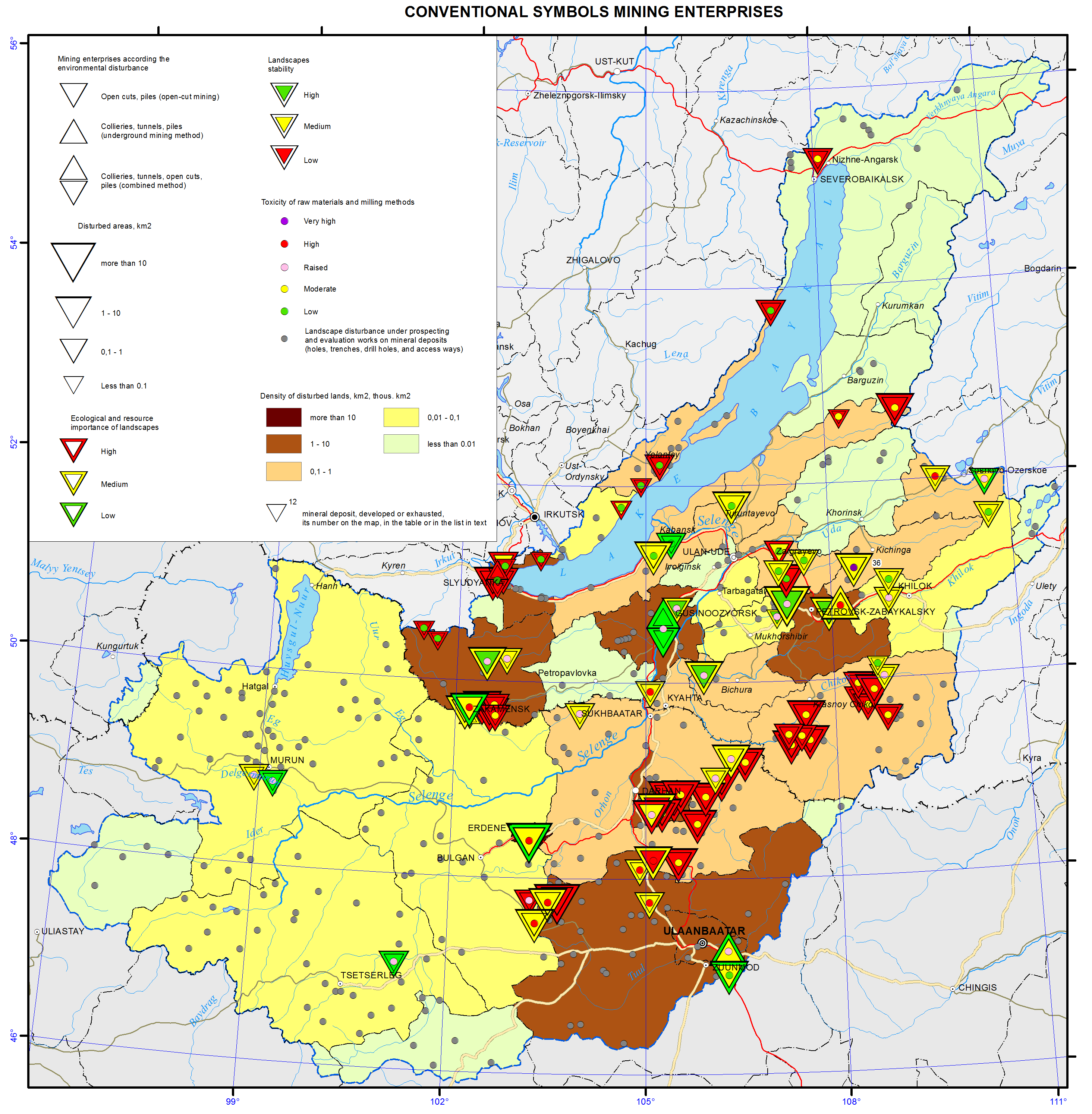
4.3 Anthropogenic pollution hotspots and their impact on the environment
4.3 Anthropogenic pollution hotspots and their impact on the environment
Severobaikalsk industrial hub covers part of the district Severobaykalsky and stretches in the latitudinal direction along the Baikal-Amur Mainline (BAM) (pic. 4.3.1). The region has been developed since 1974. Around the time, Severobaykalsk was built on the northern coast of Lake Baikal, and the large settlements New Uoyan, Angoya and Yanchukan were built to the east of it. In the district, 176 quarries have been developed and only 30% of them are partially remediated. Construction of BAM has led to the rapid population growth in the region (from 6.5 to 80 thousand). Construction of the settlements has often preceded construction of wastewater treatment facilities, landfills for industrial waste and dry garbage, etc. Currently, permanent residents of the settlements Nizhneangarsk, Dushchakan, Holodnoe and Uoyan are facing environmental issues and a lack of adequate waste treatment infrastructure [1].
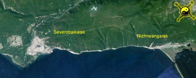
Pic. 4.3.1 Severobaikalsk industrial hub (Google)
In Severobaykalsk, the major air polluters are construction industry enterprises «Nizhneangarskstroy», «LenBAMstroy» and a plant producing asphalt and cement. Only 3% of all emissions by the plants is caught and contained, the rest is emitted into the environment. A considerable input to atmospheric pollution comes from 26 heating stations. Annually, 2.5 thousand tons of ash, 0.5 thousand tons of sulfur dioxide and 2.3 thousand tons of nitrogen oxides are emitted into the atmosphere (pic. 4.3.2). The contribution of transport to air pollution is approximately 26%. In recent years, emissions from stationary and mobile sources are continuously increasing. As a consequence, air pollution over Lake Baikal is worsening [1].
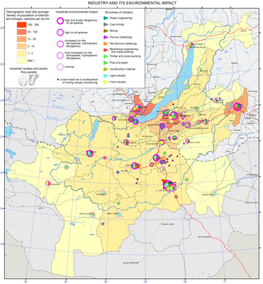
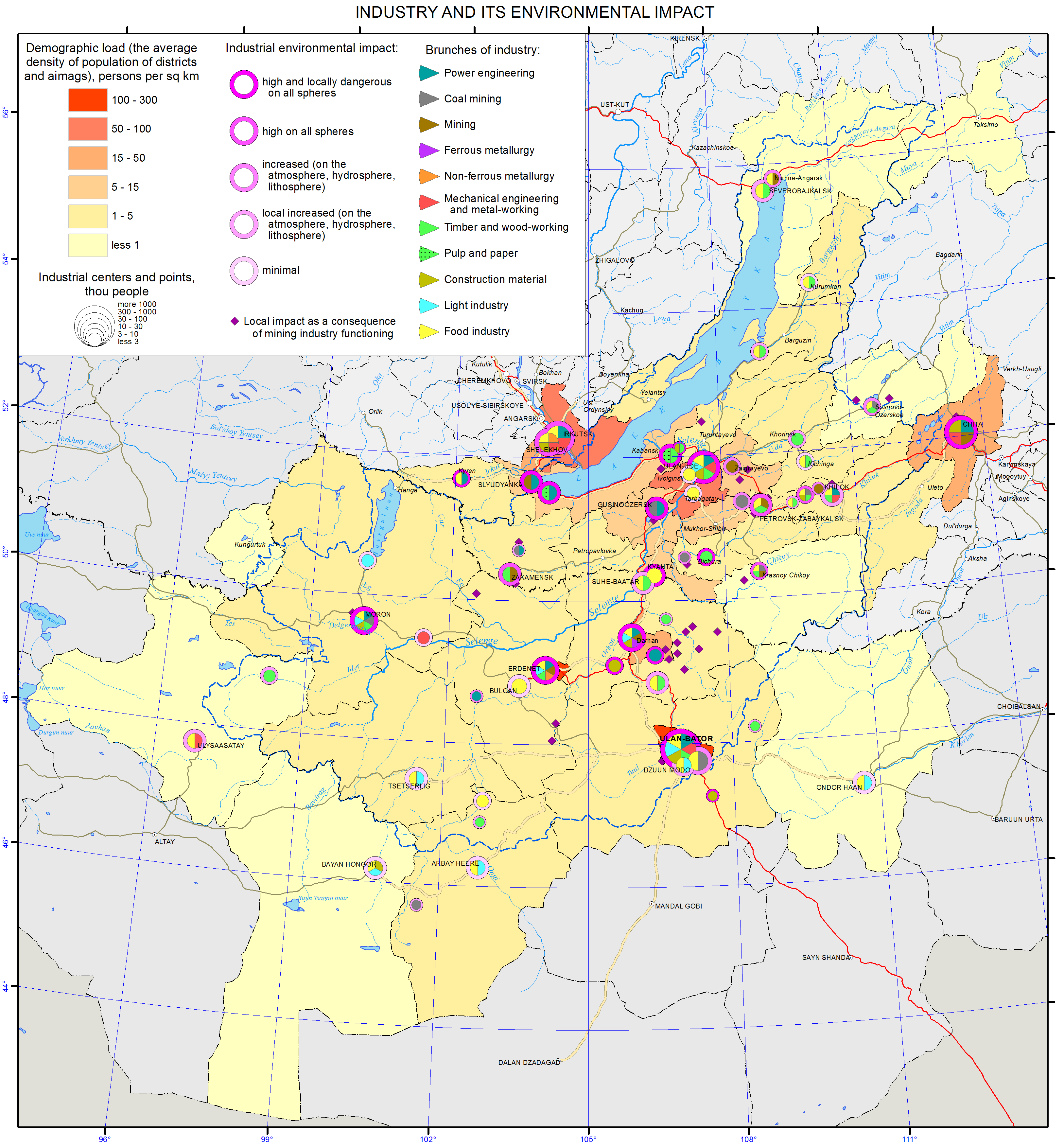
Pic. 4.3.2 Industries and their environmental impact of Baikal basin [3]
In the town of Nizhneangarsk, the total pollutant emissions have stabilized in recent years and are about 3 thousand tons per year. During winter, 22 coal-fired heating stations work in the village. With the annual consumption of about 18 thousand tons of coal, the stations emit 5.3 tons of ash, 2.5 tons of carbon monoxide and 1.3 tons of sulfur dioxide into the atmosphere every day. Thus, a zone of emission and dispersal of atmospheric pollutants forms over the northern shore of Lake Baikal. The zone stretches along Lake Baikal and its area for Severobaikalsk is approximately 100 km2, while for Nizhneangarsk it is 26 km2.
Nizhneselenginsk industrial hub is located in the western part of the district Kabansky of the Republic of Buryatia and stretches along the left bank of the Selenga river. There are major industrial centers in the towns of Selenginsk and Kamensk and the village of Kabansk (pic. 4.3.3). Among the major industrial polluters are Selenginsk Pulp and Paper Mill (SPPM) and Timlyuysky cement plant (TCP) [1].
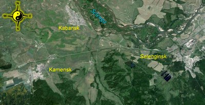
Pic. 4.3.3 Nizhneselenginsk industrial hub (Google)
During last year, emissions of SPPM amounted to 30.6 thousand tons. The share of solids was 23%, while liquid and gas emissions together accounted for about 77%. Carbon oxides were the main «ingredients» of the gaseous emissions of SPPM, constituting about 92% of the total amount of gaseous substances. The harmful sulfur compounds accounted for 4.9%, including 1.5% of sulfur dioxide. Nitrogen oxides accounted for 0.6% only [1].
In the village of Kamensk there are several enterprises, including Timlyuysky cement plant, a plant producing asbestos and cement, a brunch of electricity distributing company «Baikal electricity networks», and motor carrier enterprises. The greatest input to particulate matter emissions into the atmosphere comes from Timlyuysky cement plant. Out of the total emissions of the plant estimated to be 9287.1 tons, particulate matter accounted for 77.7% (i.e., 7189 tons). Overall, the main pollutants were benzopyrene (4.5 MPC), carbon disulfide and formaldehyde (2.0 MPC), particulate matter (1.3 MPC).
For cement production, limestone mined in Tarakanovskiy field, near the village of Kamensk, and loam from Timlyuyskiy field are used. The impact of the mining operations on the air quality has not been evaluated. The quarry dumps accumulated exposed rocks of a total volume of 190 thousand cubic meters. The mining operations covered 925 hectares, out of which 12 hectares only have been recultivated (pic. 4.3.4). The issue of safe disposal of mining waste has not been resolved.
Pic. 4.3.4 The technogenic impact of mining on the environment of Baikal basin [3]
Ulan-Ude industrial hub is the largest in terms of population and occupying territory. In the city, there are 67 industrial and 36 motor carrier companies, and 162 heating stations (including 112 industrial and 50 small heating stations). There are an estimated 6043 sources of harmful emissions into the atmosphere, of which 1784 (61%) sources are equipped with emission filters and/or emission containment equipment [1].
The main contribution to total emissions comes from the city’s Central Heating Plants (41.9%), Aviation Plant (12.2%), and motor vehicles. Central Heating Plants emit annually more than 54 tons of harmful substances, including over 30 tons of soot. According to Buryat Center of Hydrometeorology, exceedances of established thresholds were observed for particulate matter, phenol, formaldehyde (2 MPCs), nitrogen dioxide (1.5 MPCs), and benzopyrene (12 MPCs). Emissions into the air from stationary pollution sources amounted to 47.36 thousand tons, while emissions from vehicles were an estimated 40.88 thousand tons (46.3% of the total emissions in the city). The emissions from stationary sources were mainly accounted for by particulate matter (23.56 thousand tons), sulfur dioxide (12.62 thousand tons), and carbon monoxide (7.30 thousand tons). The priority pollutants were benzopyrene (6.8 MPC), formaldehyde (2.3 MPC), phenol (2.0 MPC) and nitrogen dioxide (1.5 MPC). Compared with the previous year, pollution levels by benzopyrene, formaldehyde and sulfur dioxide have decreased. However, the emissions of other pollutants remained unchanged [1].
Ulan-Ude city is surrounded by numerous organized and unorganized landfills, dumps and quarries of mining enterprises, specializing in production, transportation and processing of nonmetallic minerals used as building materials. Another growing concern is public health protection from possibly harmful impact of noise, vibration and electromagnetic fields.
Gusinoozersk industrial hub covers the area around Lake Gusinoe in the central part of Selenginskiy district of the Republic of Buryatia. Gusinoozersk city is the center of both the industrial hub and the district (pic. 4.3.5). The main industries are coal mining and electric and thermal power generation. Environmental situation in the area remains grave. The largest enterprises, which account for most of the pollution, are Gusinoozersk coal mine, Holboldzhinskiy coal opencast, and Gusinoozersk electric and thermal power plant.
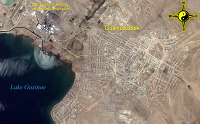
Pic. 4.3.5 Gusinoozersk industrial hub (Google)
In Gusinozersk mine’s waste heaps, a total of 72 thousand m3 of solid waste is accumulated. The mine’s lease area is 350 hectares, of which 100 hectares have been recultivated. In Holboldzhinsk opencast mine, which is the largest enterprise of its type in the Republic, 220 million m3 of waste rock are accumulated in dumps. The total area affected by mining is 900 hectares, of which 45 hectares have been reclaimed and 620 hectares are occupied by dumps (pic. 4.3.6).
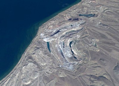
Pic. 4.3.6 Gusinozersk mine’s waste heaps (Google)
Within the industrial hub, Lake Gusinoe is the only source of drinking and industrial water supply to the city and nearby communities. One of the main sources of pollution is Gusinoozersk power plant, which uses the lake as a natural cooling facility. During winter, a polynya of more than 2 km2 in diameter forms in the lake. In the zone subjected to the thermal influence, the water temperature exceeds background levels by 13-14 °C, which is 1.5 - 2 times higher than the normal temperature. Thermal waters contribute to algal bloom and ecosystem changes in the lake. Every day the lake receives 15-16 thousand m3 of inadequately treated water from the city and the power plant’s treatment facilities; 2 thousand m3 of water from industrial settling tanks; and 2 million m3 of thermal water after cooling the turbines.
Emissions into the air from stationary pollution sources amounted to 29.01 thousand tons, while vehicle emissions were 2.49 thousand tons. The emissions from stationary sources were accounted for mainly by particulate matter (10.37 thousand tons) and sulfur dioxide (13.48 thousand tons). In recent years, air pollution by particulate matter, sulfur dioxide, carbon monoxide tends to decrease, while there is a slight increase in nitrogen dioxide levels [1].
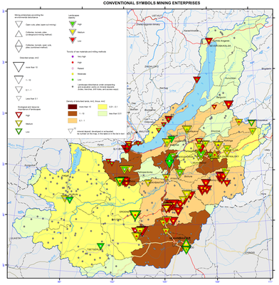
Kyahta industrial hub stretches along the border with Mongolia. Three settlements – Kyahta, Naushki and Horonhoy – are part of the hub. The biggest polluter in the area is Kyahta fluorspar mine located near Horonhoy, a station along the railway connecting Ulan-Ude and Ulan-Bator [1]. The main target product of the mine is fluorite concentrate. Annual capacity of the mine is 165 thousand tons per year. The mine has a tail dumping area of 60 hectares, of which 46 hectares are used. The volume of accumulated waste in the dump is 1900 thousand m3. The tailings are composed of fluorite (12.8%), silica (55-60%), calcium (1.5%) and clay (7-10%).
The town of Kyahta is among the most contaminated locations in Buryatia (4.3.7). Sources of surface water pollution are inadequately treated sewage of a cantonment and spinning-knitting factory, discharges of untreated municipal wastewater, as well as disorganized storage of slag and coal by heating stations, poor municipal solid waste management within the Kyahtinka river basin.
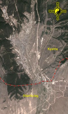
Pic. 4.3.7 The towns of Kyahta (Russia) and Altanbulag (Mongolia) (Google)
Emissions into the air of the city from stationary sources totaled 4.75 thousand tons, while emissions from vehicles amounted to 1.67 thousand tons. The emissions from stationary sources were accounted for by mainly particulate matter (2.38 thousand tons), carbon oxide (1.53 thousand tons) and sulfur dioxide (0.67 thousand tons). The levels of other regulated pollutants did not exceed the MPCs [1].
Zakamensk industrial hub covers the central part of Zakamensky district along the banks of the Dzhida River. The hub has formed due to exploration and mining of mineral resources in the area. The largest enterprise in the hub was Dzhida tungsten-molybdenum plant that conducted open cast mining of Inkurskiy and Holtosonskiy complex ore deposits. The plant operated for over sixty years and ceased operations in 1996. The closure of the plant was not done according to sanitary and environmental guidelines, i.e. remediation of affected land was not conducted, discharges of contaminated mine water into surface water bodies were not managed, environment protection measures designed for the plant were not implemented (pic. 4.3.8). All these led to a situation when with the plant closure the negative impact of its waste on the environment and the population has not decreased, but increased significantly [7].
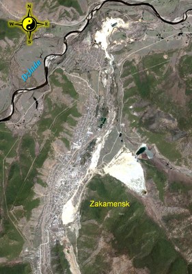
Pic. 4.3.8 Zakamensk industrial hub
For many years, the situation at the former plant remained environmentally disadvantaged. Environmental protection measures for the affected area were planned in the federal program «Ecology and Natural Resources of Russia in 2002-2010» but have remained unfulfilled. Only in 2011, the first stage of work on reclamation of 600 hectares of land occupied by man-made sand was carried out. The work was done by «Acropol Group» Ltd. through its subsidiary JSC «Zakamensk» - the owner of these man-made deposits. The work included relocation of 3.2 million tons of sand from the Modonkul river valley into a former hydraulic dump of the beneficiation department of the plant (pic. 4.3.9). The work was funded from the federal budget, and 500 million rubles were allocated.
Pic. 4.3.9 Relocation of sand from the Modonkul river valley into a former hydraulic dump.
To provide jobs and develop infrastructure, mining industry has been encouraged in the area. Currently, mining and processing of limestone, volcanic ash, clay, sand and gravel are conducted. Small-scale industries producing concrete, bricks, and lime are operating. Electricity is provided by Bayangolskaya thermal power plant, for which open cast mining of the brown coal deposit «Sangino» has been going on. «Sangino» has accumulated 194 thousand m3 of tails and host rocks. The area of affected land is 1135 ha, of which 70 ha is occupied by tail dumps.
In general, the environmental situation within Zakamensk industrial hub is grave and may adversely affect public health and the environment.
South Baikal industrial hub covers the south-western coast of the lake Baikal along the Trans-Siberian railway. The major transportation hubs and industrial sites are located there; those are the towns of Baykalsk and Sludyanka, and several smaller settlements and railway stations [1].
Baikalsk Pulp and Paper Mill (BPPM) was the biggest polluter in the area until recently. It ceased operations in December 2013. During its active years, airborne emissions of BPPM spread up to 160 km north-east along the coast of Lake Baikal, entering the territory of the Baikalsk Nature Reserve, and up to 40 - 50 km or more to the west, reaching Slyudyanka and Kultuk. The main sources of emissions are small heating stations using solid fuel. Pollutant trapping/removal efficiency on some of the enterprises is less than 50%, and emissions from food industry and transport are released into the atmosphere without any treatment.
The town of Sludyanka is located on the southwestern shore of Lake Baikal (pic. 4.3.10). A major railway station, many small heating stations and individual houses with their wood-burning stoves are the stationary sources of air pollution in the town. Mobile sources of pollution are motor vehicles. Maximum one-time concentrations of particulate matter, nitrogen oxides and soot exceeded the MPCs by 1.8-2, 2.5-4.0, and 3.5-5.0 times, respectively.
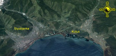
Pic. 4.3.10 The town of Sludyanka and the settlement of Kultuk (Google)
East Siberian Railway contributes significantly to the environmental pollution along its route between the towns of Sludyanka and Vidrino. Concentrations of petrochemicals, methanol, formaldehyde, total organic chlorine at monitoring stations exceeded MPCs by 2-4 times. From the railroad tracks contaminants are washed off into Lake Baikal by atmospheric precipitation and surface runoff.
Within a controlled zone in the vicinity of the town of Baikalsk, the area of polluted snow cover remains largely unchanged. During winter of 2012-2013, the area was around 270 km2 (it was 350 km2 during winter of 2011-2012).
In 2013, contamination of atmospheric precipitation reduced for the stations of Baikalsk, Khamar-Daban and Khuzhir by 25%, 33% and 11% (for the sum of monitored substances), respectively, compared with 2012.
The results of snow cover pollution monitoring in 2013 showed the reduced precipitation of suspended matter onto the lake and coastal areas of its southern part [1]. However, there were increased inputs of chromium, lead, zinc, nickel, copper, and iron near the town of Slyudyanka, the village of Kultuk and along the stretch between the village of Kabansk and the town of Baikalsk.
In 2013, the stationary sources of pollution within the Southern Baikal and Northern Baikal industrial hubs emitted 10.2 thousand tons of pollutants into the atmosphere (10 thousand tons in 2012), discharged 21.7 million m3 of wastewater (40.2 million m3 in 2012), generated 829.4 thousand tons of solid waste (974.1 thousand tons in 2012).
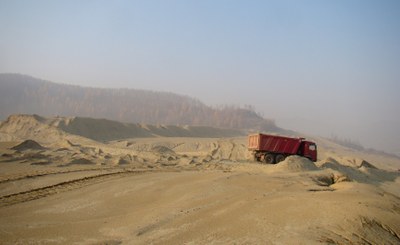
Within the Petrovsk-Zabaikalskiy industrial hub, the major air and water polluters are the town of Petrovsk-Zabaikalskiy, Tugnuiskiy coal mine (pic. 4.3.11) and a railway complex [1]. A metallurgical plant located in Petrovsk-Zabaikalskiy emits almost 90% of the total emissions in the district – dust, sulfur dioxide, carbon monoxide, nitrogen oxide and hydrocarbons. Among hydrocarbons, benzopyrene emissions significantly exceeded the MPC – by 10 times.
Pic. 4.3.11 Tugnuiskiy coal mine (Google)
Agriculture too contributes to environmental pollution. Stationary livestock farms and summer farms, usually located near water bodies, are of special concern. Water discharges from irrigation systems and run off from fields with an excess of fertilizers negatively impact the environment. Many municipalities still do not have wastewater treatment facilities, the available treatment facilities either do not work or work with a very low treatment efficiency.
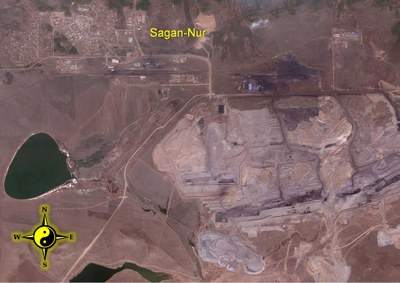
The largest sources of environmental pollution within the Mongolia are sewage treatment plants of the big cities - Ulaanbaatar, Darkhan (pic. 4.3.2 and pic. 4.3.12) and Erdenet (pic. 4.3.13), mining and ore processing enterprises (pic. 4.3.4), and light industry enterprises (particularly skin and wool processing facilities) [2,8].
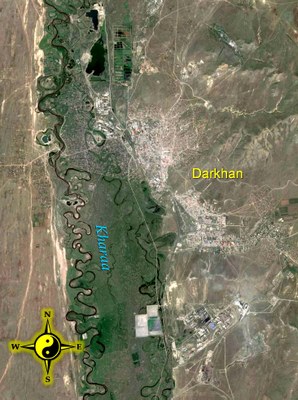
Pic. 4.3.12 Darkhan city (Google)
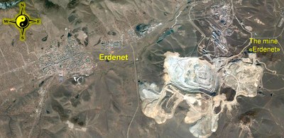
Pic. 4.3.13 Erdenet city (Google)
Within the frameworks of the project «Integrated natural resource management in the Baikal Basin transboundary system», a survey of pollution hotspots within the Selenga River basin was carried out by the non-governmental organization «Mongolian water forum – Water discussion» [9].
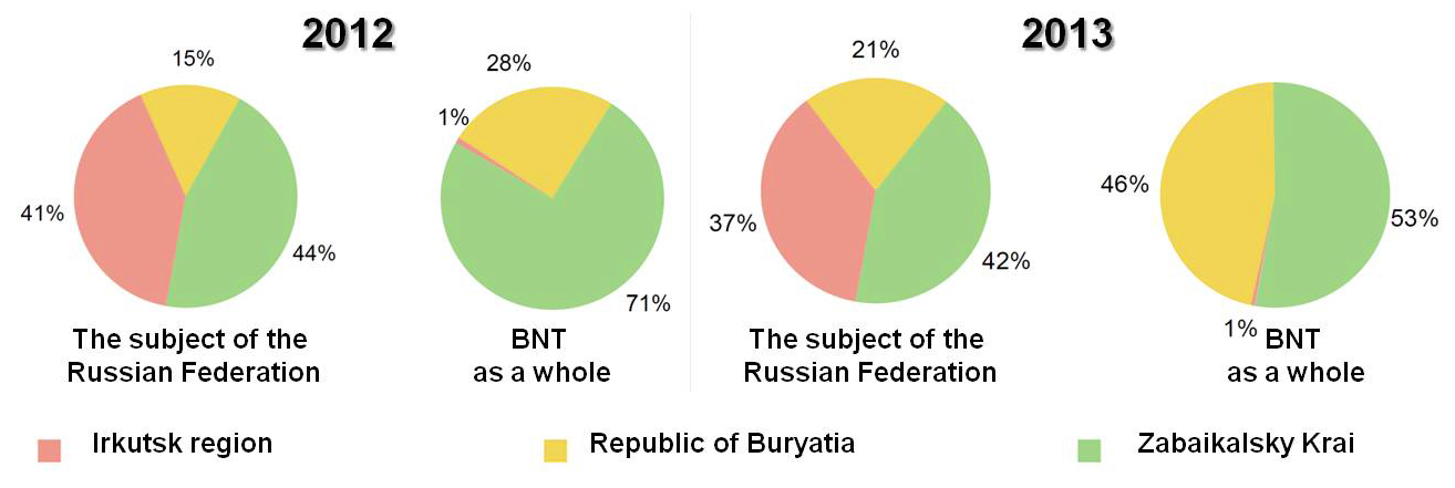
Waste generation and disposal. The volume of waste generated within the BNT increased by 31.9% in 2013 compared with the previous year (110.0 million tons in 2013, 83.5 million tons in 2012). This was associated with an increase in volumes of overburden rock in the Republic of Buryatia (Fig. 4.3.14) [1,11].
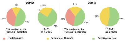
Fig. 4.3.14. The ratios of waste volumes in 2012-2013.
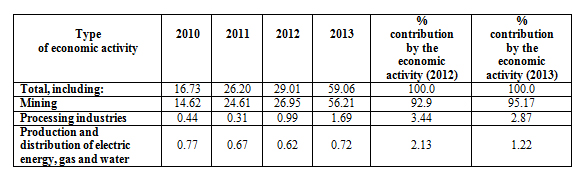
In general, 59.1 million tons of waste were generated in the Republic of Buryatia in 2013, which was two times more than in the previous year (Table. 4.3.1) [12].
Table 4.3.1 Waste generation within the Republic of Buryatia by type of economic activity in 2010 - 2013 (million tons).
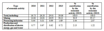
The increase in waste volumes in 2010-2013 was directly related to the extraction of coal, e.g. in Mukhorshibirsky district (JSC “Razrez Tugnuisky”) 17.96 million tons of waste were generated in 2013 (0.006 million tons in 2012), while in Selenginsky district (JSC “Coal Company “Bain-Zurhe”) 24.3 million tons of waste were generated in 2013 (7.0 million tons in 2012).
The bulk of the generated waste is waste of the hazard class 5. A total of 0.49 million tons of waste were disposed of at waste disposal sites (sanctioned landfills), while 2.06 million tons of waste were disposed of within the industrial facilities, where the waste was generated. Within the Republic of Buryatia there were 304 waste disposal sites, including 7 landfills for municipal solid waste, 294 sanctioned dump sites, 1 landfill for municipal solid and liquid waste, 1 dump site for forest waste and 1 reinforced concrete reservoir for temporary storage of industrial waste. As of January 1, 2014, in the Republic of Buryatia there were 147 illegal dump sites over a total area of 69 hectares. In 2013, 1191 illegal dumps were identified, and 1282 illegal sites were cleaned up.
