Chapter II. Conditions of natural environment
2.1 Surface and ground waters
2.1 Surface and ground waters
In the north of the Russian part of the basin, the biggest rivers are the rivers Angara, Barguzin and Turka. The middle part of the basin includes Selenga River with its major tributaries – the rivers Uda, Khilok, Chikoi and Dzhida. In the Mongolian part of the basin, the biggest rivers are the rivers Selenga, Ider, Chuluut, Khanui, Orkhon, Eruu, Kharaa, Tuul, Egiin-Gol, and Delgermurun.
Differentiation of the river network density of the Lake Baikal basin has a clearly pronounced zonal nature: from 0.1 km/km2 at the south-eastern boundary to 0.9 km/km2 on the coastal ridges and in the northern territories [1]. A high river network density is characteristic of the taiga zone, especially of ridges and valleys immediately adjacent to the lake. In general, the northern part of the basin is characterized by favorable conditions of flow. Mountainous terrain, steep slopes and the presence of permafrost contribute to a rapid discharge of water into the main water streams, namely, the Upper Angara and the Barguzin, and to the development of the river network. The highest density is specific to the western slopes of the Barguzinsky (0.92 km/km2) and Khamar-Daban ridges (0.69 km/km2). Among the plain territories, the most watered areas are the Barguzinskaya valley (0.89 km/km2) and the area of the Selenga river delta (0.68 km/km2) (pic. 2.1.1).
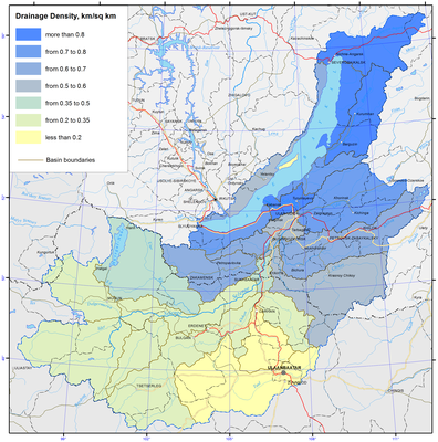
Pic. 2.1.1 River network density [1]
The middle part of the basin represents a border of forest and steppe, and is characterized by the mid-mountain terrain and a high occurrence of sandy and sandy loam soils. The presence of these factors provides for the average river network density ranging from 0.35 km/km2 in the middle reaches of the Selenga River and 0.55 km/km2 for the Chikoi river basin to 0.61 km/km2 for the Khilok and Dzhida river basins.
In physical and geographical terms, the south-western part of the basin, i.e. the area of Lake Khuvsgul, represents a forest-steppe with the high-mountain depression terrain, and is characterized by a lower river network density ranging from 0.32 km/km2 for the Delgermurun river basin to 0.34 km/km2 for the Egiin-Gol river basin. In the southern dry steppe part of the basin a low river network density is registered. This is especially typical for the Tuul and Kharaa river basins; here this index is below 0.2 km/km2.
Because of the disintegration of relief and a considerable contrast in the precipitation regime of the depressions and mountain ranges in the Russian part of basin, the average amount of annual runoff varies to a great extent – in the depressions it is seldom less than 2.5 l/s·km2, that is including some sites without an outflow, while the runoff on the range slopes exceeds 25 l/s·km2, averaging 5-10 l/s·km2 for the most part of the territory. The regime of most of the rivers is of Far East type with the maximum runoff in the rainy period and rain alimentation in the second half of summer. Many medium-sized rivers freeze in winter thereby contributing to the issue of winter water supply.
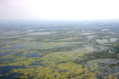
In the North of basin the Verkhnyaya Angara River flows from the southern slope of the Delun-Uransky mountain range and falls into Angarsky Sor bay, located in the northern part of Lake Baikal. The river forms a vast delta with a great number of river channels and lakes (pic. 2.1.2).
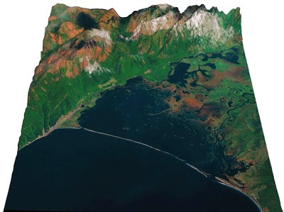
Pic. 2.1.2 The delta of Verkhnyaya Angara River (digital relief model, BINM SB RAS)
The length of the river is 438 km, water catchment area is 21400 km2, the general fall is 120 m. The total number of tributaries is 2291 with the overall length of 10363 km (0.45 km/km2). The average long-term water discharge is 265 m3/s (8.4 km3/year) [3,4].
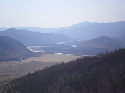
The Barguzin River originates at the spurs of the South-Muysky mountain range; falls into the Bay of Barguzin of Lake Baikal. The length of the river is 480 km, water-catchment area is 21100 km2, the general fall is 1344 m (pic. 2.1.3). The number of rivers within the basin is 2544 with the total length of 10747 km (0.51 km/km2). During the high water period, the river is navigable at the extent of 250 km and has a great significance for fishing. The basin economy is based on agriculture, and in particular irrigational agriculture. The average long-term water discharge is 130 m3/s (4.1 km3/year) [3,4].
Pic. 2.1.3 The Barguzin River
The Turka River originates in the southern slopes of Ikatsky range at the elevation of 1430 m and falls from the east into the middle part of Lake Baikal, 140 km to the north-east of the Selenga delta. The length of the river is 272 km, water-catchment area is 5870 km2, and general fall is 975 m. The lower part of the basin includes Lake Kotokelskoe with an area of 68.9 km2. The river has a great significance for fishing industry. The upper stream of the river is the center of exploration works for placer gold. The average long-term water discharge is 1.6 km3/year [3,4].
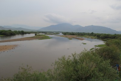
The Selenga River of Mongolian part takes its origin from the confluence point of the rivers Delgermurun and Ider. The total basin area of the Selenga river is 445 272 км2 km2, among this 67% is located in Mongolia. The Mongolian part of the Selenga river basin spans over 6 aimags - Bulgan (46.3%), Selenge (27.6%), Khuvsgul (25.3%), Arkhangai (0.7%) and Orkhon (0.04%) [2].
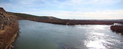
The Selenga River in the Russian part flows across the middle-mountain heavily indented location. The channel slope is 0.36 ‰. The width of the river valley varies from 2 to 25 km. In narrow places the river consists of one slightly meandering channel, in the wider parts the river channel divides into arms. The main channel and the river arms are meandering, at the abrupt turns the shores are intensely eroded (pic. 2.1.4). The width of the river in the low-water period is 100-150 m, depth at the river pool is 4-5 m, at the bar area is 0.5 – 1 m, at shallow places – 0.5 m. The velocity of current in the low-water period is 1 m/s, at disparate bars rising to 2-2.5 m/s. The bottom of the river is predominantly composed of pebble, or pebble and sand. The height of the shores is 1-2 m.
Pic. 2.1.4 The Selenga River
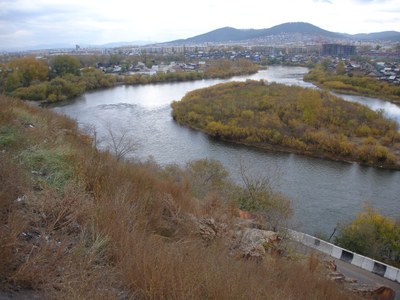
The Selenga has a delta with the area of about 1120 km2, made up of river channels and islands, formed of river sediment (pic. 2.1.5).
Pic. 2.1.5 The delta of Selenga river
Annually, the Selenga river discharges about 2.7 million of sediment load, increasing the area of the delta [3,4]. It is the delta area which has the shortest distance between the two shores of the lake – 26 km. The Selenga section of Lake Baikal is the area of accumulative shores, having the maximal length and consisting of the external part of the Selenga delta and bars, separating the lake from the bay: Bay of Proval, located to the north-east of the Selenga delta the bay of Sor Cherkalov, located to the south and south-west of it. Analysis of multi-temporal cartographic and space-image materials, fieldwork data suggest that the delta area grows disproportionately at its disparate parts. The maximal growth of the delta takes place in the north-eastern section, adjacent to the Bay of Proval, in particular, in the area of Lobanovsky water channel, reaching several tens of meters per year in some periods. The western sector of the Selenga delta, adjacent to the Bay of Sor Cherkalov protrudes with less velocity. Relatively stable in terms of growth is the northern section of the delta, located between the Srednyaya and Northen Ust’ channels [5].
The Dzhida River originates on the southern slope of the Khangarulsky mountain range. The upper part of the basin has an average absolute elevation of more than 1500 m, as the river flows through a ragged heavily indented location (pic. 2.1.6). The average slope of the river is 2.7 ‰, in the middle stream – 1 ‰, slopes - 200–300 ‰. The Dzhida river is the fourth largest tributary of the Selenga river (12.5 % of the Selenga river basin), the amount of the river runoff is 15 % of the overall amount within Russia [3,4]. The ratio of water influx from the area of 4920 km2 from Mongolia is 25 % (0.61 km3). The river is fed primarily through rains, the inundation stage does not exist, the ratio of winter runoff to underground alimentation is 6%. The upper, north-western part of the basin lies in the zone with episodic freezing, and the lower – with annual freezing. Some sections of the Dzhida River are characterized with karst rocks, but in general the impact of karst phenomena on the river flow is insignificant.
Pic. 2.1.6 The Dzida river
The Temnik River rises on the northern slope of the Khamar-Daban mountain range. The river basin is predominantly mountainous, since only the lower part of the basin has grassland landscapes. The average slope of the river is 3.6 ‰. The river is fed through rains, and inundations are observed from May to September. The specific runoff is 7 %, of the flow into the Selenga on the Russian territory. The ratio of winter runoff is 7 %, the river freezes in an episodic way, once in five years.
The Chikoi River is the biggest in terms of the basin area and the amount of water runoff among the Selenga tributaries, while its water catchment is about 10 % of the Selenga basin and 31 % of the catchment in Russia (pic. 2.1.7). About 25 % (2.14 km3) of the runoff comes from Mongolia. The average slope is 1.65 ‰, in the middle stream – 1.2 ‰ and lower stream – 0.58 ‰, mountain slopes - 200–300 ‰. The average river runoff, formed in Russia, accounts for 40 % of the water influx into the Selenga. The conditions of runoff formation in the upper and lower parts of the Chikoi basin as well as on the water catchment area of the left-bank and right-bank tributaries are quite different. The river alimentation comes from rains, inundation due to the spring snow melting is rare and constitutes no more than 20 % of the annual runoff, winter runoff – 6 %, on tributaries - 2 – 3 %. The upper part of the basin lies within the zone of non-freezing or rarely freezing rivers, the middle part in the zone of episodic freezing and the lower part within the zone of annual freezing. In terms of the specific runoff, the Chikoi river ranks second place among the major tributaries of the Selenga following the Temnik [3,4,6].
Pic. 2.1.7 The Chikoi river
The Khilok River originates from Lake Shakshinskoe to flow through the bottoms of prolonged intermountain depressions at the elevation of 500-800 m, between the chain of mountain ridges with flattened forms and absolute marks of 1300–1800 m. Slopes of the basin valleys are covered mainly with mountain and taiga vegetation, while the bottoms of the valleys tend to be taken up by grassland and forest-grassland sections. The average slope is 0.52 ‰. The area of the river basin is 26 % of the Selenga basin within Russia and the amount of water influx is 19 %. River alimentation is from rain, the stage of spring snow melting is weakly manifested and does not exceed 20% of the annual runoff. Winter runoff is less than 6 % for the mouth part, while in the upper and middle part of the Khilok River there is no runoff as a result of freezing. The specific runoff indicators are 1.5 times less than those for the Dzhida River, and more than 2 times less than for combined runoff for the Temnik and Dzhida rivers.
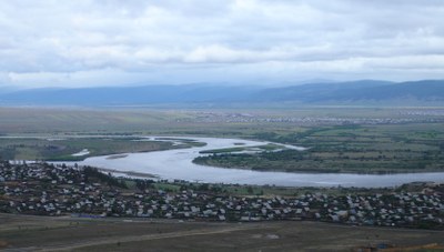
The Uda River originates in the south-western part of the Vitim plateau at the elevation of 1055 m, flows into the Selenga on the right side, 156 km off its mouth (pic. 2.1.8).
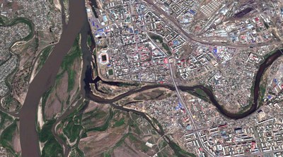
Pic. 2.1.8 The Uda river empties into the river Selenga (Google)
The length of the river is 467 km, water catchment area is 34800 km2, general fall of the river is 583 m. Average absolute elevation of the upper part of the Uda basin is 900 –1100 m. The average fall of the river is 1.2 ‰, in the lower stream – 0.7 ‰. The river basin is the third largest among the tributaries of the Selenga (23% of the water catchment area of the Selenga in Russia) and fourth largest in terms of the amount of water influx (13.4 %). The river network in the basin area is moderately developed, average value of density coefficient is equal to 0.39 km/km2. The upper part of the basin has vast spaces of wetlands as well as a great number of small lakes with the surface area of less than 1 km2) [4,7].
The modulus of flow is 2.0 l/s km2, the lowest as compared to other five largest tributaries of the Selenga. The river alienation is from rain, but as a result of spring snow melting water runoff reaches 30 % of the annual amount (pic. 2.1.9). The inundation stage manifests itself in the low-water years and the medium-water years. The ratio of the winter runoff of 10 – 12 %, formed due to the flow of non-freezing right-hand tributaries in the middle and lower parts of the basin. The tributaries of the upper part of the basin and the Uda itself in the middle stream freeze on the annual basis, while the left-bank tributaries in the middle and lower part of the basin freeze occasionally [2].
Pic. 2.1.9 The Uda river in Ulan-Ude
The Eruu River originates in the high reaches of the Khentii mountain range. The Sharlan River joins the Hongi River, and the Eruu River starts from the junction point of these two rivers (pic. 2.1.10). The river basin spans over four aimags, namely Selenge (69.1%), Tuv (23.8%), Khentii (7.0%), Darkhan-Uul (0.1%), and has a total area of 22 282 km2. The Eruu river basin authority is located in the center of Eruu soum in Selenge aimag.
Pic. 2.1.10 The Eruu river
The Bayan River takes its origin from the south-western branch of Khentii mountain range. The river’s confluence point with the Sognogor River is the source of the Kharaa River (pic. 2.1.11). The area of the Kharaa river basin is 17 667 km2and extends over Tuv (41.5%), Selenge (36.6%), and Darkhan-Uul (17.2%) aimags and several districts of Ulaanbaatar city (4.8%) [8,9].
Pic. 2.1.11 The Kharaa River
The Tuul River takes its origin at an elevation of 2 000 m above sea level at the Chisaalai mountain. The river source is the confluence point of the rivers Namya and Nergui. The total area of the Tuul river basin is 50 074 km2and the basin spans over 5 aimags, i.e. Tuv (59.2%), Bulgan (20.5%), Uvurkhangai (7.3%), Arkhangai (5.0%), and Selenge (1.7%), as well as 7 districts of Ulaanbaatar city(6.3%). The capital city of Mongolia, Ulaanbaatar, is located in the river basin; the central part of the basin is, therefore, a densely populated urban area (pic. 2.1.12) [8,10].
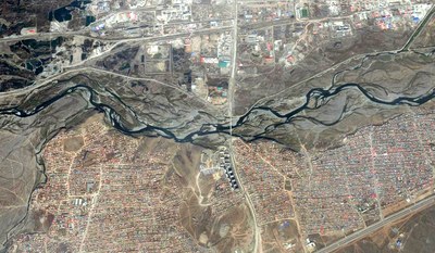
Рис. 2.1.12 The river Tuul in Ulaanbaatar (Google)
The Orkhon River originates in the east-northern part of the Khangai mountain range and flows northward joining the Selenga river in Sukhbaatar city in Selenge aimag. The total basin area of the Orkhon River, including basin areas of its tributaries - Tuul, Kharaa and Eruu, is 143 479.3 km2, 48.0% of which is part of the Selenga River basin. The biggest waterfall of Mongolia – Ulaantsutgalan – is located in the upstream of the Orkhon river (pic. 2.1.13). The river basin spans over 8 aimags - Arkhangai (38.2%), Bulgan (21.9%), Selenge (18.5%), Uvurkhangai (15.9%), Tuv (1.9%), Bayankhongor (1.6%), Orkhon (1.6%) and Darkhan-Uul (0.4%) [8,11].
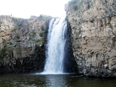
Pic. 2.1.13 The biggest waterfall of Mongolia – Ulaantsutgalan.
The Khanui River takes its source in the Khan-Undur mountains, which are in the central part of the Khangai mountain range. The river flows about 421 km towards the east-north before joining the Selenga River. The total area of the river basin is 15755 km2, which is divided between 3 aimags - Arkhangai (77.1%), Bulgan (22.7%) and Khuvsgul (0.1%) [8].
The Chuluut River originates in the western part of Gurvan-Angarkhai mountain in the Khangai mountain range. The Chuluut River flows 415 km till its confluence with the Ider river. The total river basin area is 20078 km2that span over 4 aimags - Arkhangai (95.7%), Khuvsgul (3.8%), Bayankhongor (0.4%), and Zavkhan (0.2%) [8].
The Ider River takes its source at the north side of Otgontenger mountain in the Khangai mountain range. There are several small and big tributaries, including the rivers Suman and Chuluut. The length of the river is about 465 km from its source to the mouth – its confluence with the Selenge River. The total area of the river basin is 23061 km2,which covers parts of Zavkhan (65 %), Khuvsgul (32.1%) and Arkhangai (2.9%) aimags of Mongolia [8,12].
The Delgermurun originates in Ulaantaiga mountain in Khuvsgul aimag. The river flows about 445 km till its confluence with the Ider River, together forming the Selenga River. This river basin area is 23324 km2extending over Khuvsgul (98.5%) and Zavkhan (1.5%) aimags of Mongolia [8].
Lakes are distributed unevenly across the Selenga basin which is due to the diverse relief, climate and water alimentation. The greatest number of large natural water objects is concentrated in intermountain depressions. The Selenga river basin has 5549 lakes with a total area of 616 km2. The density of lakes in the basin is less than 1 %. The more prevalent are small water objects with an area of 0.5 km2, and only 17 lakes have the area from 1 to 10 km2 and 4 lakes with the area of more than 10 km2. The biggest lake in the Selenga river basin is Gusinoe with an area of 163 km2. The biggest lakes are Kotokel (pic. 2.1.14), Shakshinskoe and Arakhlei (with surface areas of 52.6 and 58.5 km2, respectively) located in the outlet of the Khilok River [3,4].
Pic. 2.1.14 The Lake Kotokel
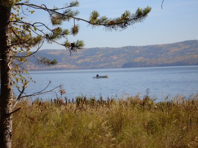
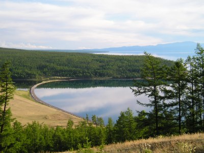
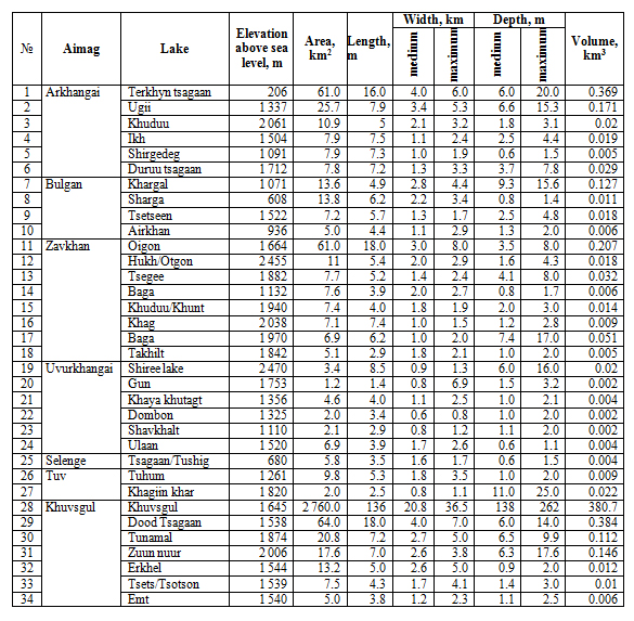
Lake Khuvsgul is the largest lake in Mongolia that contains 3/4 or 74.6% of the total surface water supply (380 km3) in Mongolia (pic. 2.1.15) [9,13].
Рис. 2.1.15 The Lake Khuvsugul
The water level in Lake Khuvsgul have increased by 1 m since 1963, the exact reason for which is unknown. However, it might be related to melting of permafrosts, increased precipitation, decreased outflow due to accumulation of sand an the bottom of the Eg river, water temperature decline and, thus, reduced evaporation from the lake surface, etc. In 1979 and 1995-1996, the water level in the lake declined significantly. It was attributed to the lower amount of precipitation during these years (table 2.1.1).
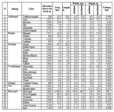
Table 2.1.1 Morphometric characteristics of lakes within the Mongolian part of Baikal basin [8,9].
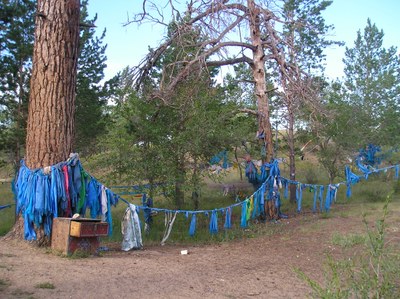
Wetlands in the Selenga river basin are comparatively rarely to be found. In most cases, wetlands are to be found in the river valleys and river mouths as well as on the shores of lakes. In the river valleys and river mouths, the most widely spread are sedge and moss types while the more drained parts have bushy wetlands. In the wetland depressions, located in the Khamar-Daban mountains (the Dzhida and Temnik river basins) there are some areas covered with sphagnum (pic. 2.1.16 ).
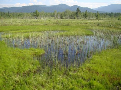
Pic. 2.1.16 The swamp on Khamar-Daban range
Large places of swampy valleys are found nearly everywhere in all the valleys. The density of wetlands varies within the range of 1 – 5 %. The most significant wetlands are found in the Khilok basin (about 10% of the catchment area) [5,14].
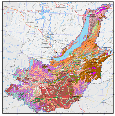
Ground waters are quite varied in terms of chemical composition and are subject to certain geochemical zonality. Artesian basins occupy intermountain depressions, composed of loose rocks of sedimentary cover and crystal rocks. They are characterized with porous zones of active water circulation. Hydrogeological massifs are composed of crystallic rocks of mountain-infolded framing and contain interstitial waters of exogenic fracture pattern. The capacity of active water exchange zone does not exceed 100-150 m. The most water-abundant are karstified carbonate rocks as well as zones of tectonic dislocations, cutting the basal complex or stretching alongside the contacts with sediment-metamorphic formations with erupted and metamorphic rocks. They are often traced by the rising water load of both cold and thermal waters. Fault waters of mountain ridges are ultra-fresh waters (with salinity of 0.003 to 0.005 g/l). In artesian basins of Baikal type (Barguzin, Verkhneangarsky), the water salinity does not exceed 0.5-1 g/l up to the depth of 2000 m, while the composition of water is mainly of hydrocarbonate-sodium and calcium-sodium type (pic. 2.1.17).
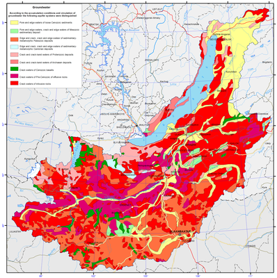
Рис. 2.1.17 Groundwater of Lake Baikal basin [1]
The major way of ground water alimentation is through infiltration of atmospheric precipitation and melted waters. Permafrost plays a significant role in the formation of ground water reserves and their regime. The replenishment of reserves takes place in the warm season, when the amount of infiltration exceeds the amount of unloading. In the course of the cold period, their unloading happens and their water levels decrease in this period. The amplitude of fluctuations during the year does not exceed 1.5-2 m.
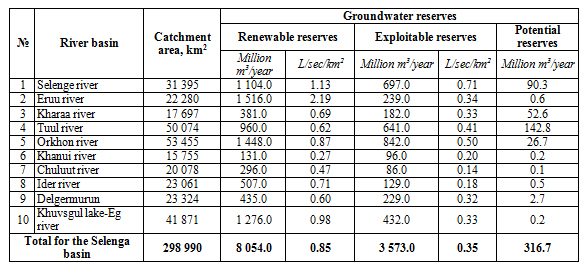
Ground alimentation of rivers relies on both the ground water and pressure artesian waters. Ground water flow on the considered territory is quite significant in scope. Deep compartmentalization of surface, dense river network, considerable gradients facilitate intensive ground flow (table 2.1.2).
Table 2.1.2 Groundwater reserves in the river basins Russian part of Baikal basin
In terms of availability of ground water, three groups of regions can be distinguished in the territory: with good availability, medium availability and little availability. The first group includes ground waters of intermountain depressions of Baikal type with virtually unlimited reserves – up to 3-5 m3/s and more. The second group includes artesian basins of Transbaikalian type with the amount of fresh water sampling up to 1.0 m3/s. The third group includes ground fault-veined waters of mountain ranges with limited (up to 5-10 m3/s) exploitation resources [3,4].
The territory of middle-sized and northern rivers of Lake Baikal has almost all the known types of curative mineral waters (thermal, cold carbon, hydrogen sulphide, radon, ferriferous). Thermal nitrogen-siliceous waters of Goryachinsk resort, located on the eastern shore of Lake Baikal, are used to treat the diseases of nervous system, skin diseases and other ailments (pic. 2.1.18).
Pic. 2.1.18 The hot springs of resort Goryachinsk
Barguzin valley has a number of resorts of the local level, such as Garga, Alla and Kuchiger. High temperature of thermal waters makes it possible to use them for acquiring thermal and electric energy. Thus, waters with the temperature of 40-70ºС can be used for greenhouse planting and hot water supply. In terms of curative properties, these waters are fit for curing the diseases of the locomotor system, peripheral nervous system and other diseases [3,4].
In Mongolia, groundwater is the main source of drinking water and water used for domestic and industrial purposes. According to some estimates, 95% of the domestic and industrial water demand is supplied by groundwater (pic. 2.1.17).
In the Selenga River basin, surface water mainly is used for irrigation but, in recent years, groundwater consumption has increased. In addition, most of mines and industries remove groundwater from exploration fields (during open pit and underground mining) to keep it dry. Industries located in cities usually use water from centralized water supply networks or own groundwater wells. Seosonal groundwater level decrease in Ulaanbaatar city is due to the fact that the rate of groundwater extraction is higher than the rate of its replenishment.
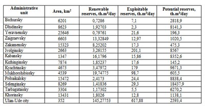
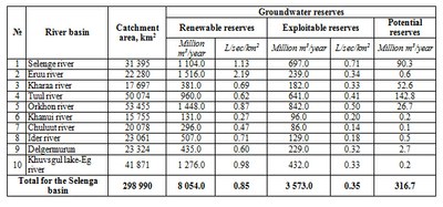
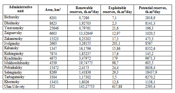
According to the Integrated Water Resource Management Plan of Mongolia [8], it is estimated that the renewable groundwater reserves are 8.1 million km3/year, the potential exploitable groundwater reserves are about 3.6 million km3/year and, in the Selenga River basin, the potential reserves are 316.7 million m3/year. However, these estimates should be treated as approximate. The groundwater reserves in each river basin were estimated based on hydrological data for the region, the type of geological formation in the area, estimates of groundwater recharge, regional field surveys (including test drilling), etc. (Table 2.1.3)
Table 2.1.3 Groundwater reserves in the river basins Mongolian part of Baikal basin
Document Actions
2.2 Soils
2.2 Soils
The great distance of the Lake basin from south to north determines latitudinal changes of the thermal factor and the related soil and vegetation cover. In addition to these main regularities, there is also the influence of exposition, meridional and mountain zonality. Of great significance is the role of permafrost, heterogeneity of soil-forming rocks, complex evolution of landscapes in the past and their transformation as a result of anthropogenic impact. The prevalence of mountain relief led to the domination in the region of East-Siberian mountain-taiga landscapes. A considerable part of the territory is covered with mountain taiga, while portions of grassland landscapes, associated with intermountain depressions, run far into the northern regions.
Lake Baikal basin is characterized with two types of soil: soils of mountain territories and soils of intermountain depressions [3,4]. Soils of mountain territories are thin and formed as a rule on eluvium and eluvium-deluvium of intrusive mountain rocks and to a lesser extent – on eluvium and eluvium-delivium of effusive, sediment and metamorphic rocks. Soils of intermountain depressions are formed on different loose sediments, on sandy and clay layers (pic. 2.2.1).
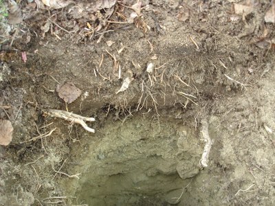
Fig. 2.2.1 Soil profile in the Valley of Verkhnyaya Angara River
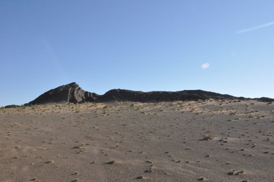
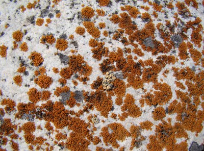
In the north of the territory, the upper part of the taiga belt is dominated by mountain permafrost soils containing iron, among which there are certain types with the signs of gleization. The latter manifest themselves most clearly on the sites with a more powerful (5-8 сm) organic horizon in form of a condensed and constantly wet layer of lichen and moss. In the zone of bald mountains, soils are widespread on the sites of fine earth. The places covered with large-block stony deposits and outcrops of solid rocks and do not have soils (pic. 2.2.2).
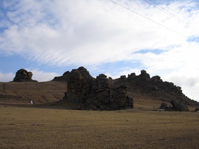
Pic. 2.2.2 Stone deposits and rock outcrops
Verkhneanagrskaya depression and mountains are dominated by bleach alluvium-ferriferous soils, while the slopes of mountains are dominated by permafrost-taiga soils. The latter are characterized with slight differentiation of soil profile and high concentration of mobile form of iron and shape on loose sediments of small thickness. The major property, uniting all the types of soils in the northern part of the basin, is their cryolithic character (pic. 2.2.3-a,b,c).
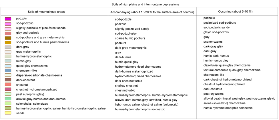
Pic. 2.2.3 Soils of Lake Baikal basin [1]
(Legend to the pic. 2.2.3)
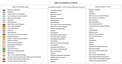

The area showing the simultaneous features of continuous and intermittent permafrost, embrace more than 90% of land resources. The geocryological feature of the territory is the correlation between permafrost and the lowering of relief. Soils in the bottoms of valleys and depressions have a lower temperature and the permafrost has the greatest thickness. Permafrost meadow-chernozem soils occupy flat or slightly sloping valleys on deluvium clay and sandy areas and ancient lake sands. Permafrost-taiga soils and ash gray soil are shaped at the elevation from 1000 to 1300 m. The most fertile are permafrost meadow-chernozem soils which yield the highest amount of harvest. These soils are characterized with a high concentration of humus and nitrogen as well as average concentration of sodium. Out of permafrost soils, the least productivity is observed on permafrost grey forest soils. Of intermediary importance are permafrost meadow soils.
The permafrost is related with other cryosolic processes and phenomena such as frost mold, thermokarst, soilfluction, polygon form of relief and ice [3,4]. Frost molds are associated mainly with the powerful layer of loose sediment. Seasonal frost molds are shaped in January and February on the sites of permanent springs, while their height can be 3 m and their diameter - 20-50 m. Thermokarst processes are well developed on the west shore of Lake Baikal, in the Barguzin river valley and at some portions of trough valleys. Thermokarst manifests itself through the formation of thermokarst lakes, swampy lowlands and funnels. The size of thermokarst depressions varies from 10-20 to 150-200 m. The high-mountain belt has well-developed forms of soilfluction: overmoistened melted soil float up from the places free of vegetation. Not infrequently soilfluction covers entire blocks of mountain rocks, sometimes with big trees. In the medium mountains area this phenomenon is slightly manifested and is observed mainly on the northern slopes.
The area of mountain taiga incorporates soils with eluvium-illuvium and non-differentiated profiles (pic. 2.2.4). Baikal range and Severobaikalsky uplands are dominated by ashen-grey and podzolized brown soils with the admixture of peat-brown soils. They are characterized with small thickness of profile, which in the layers of ashen-grey soil can be 30 cm, and in the mountains of Baikal region is about 40 cm. The thickness of brown soils, which can be seen as being at the incipient stage of soil-formation, is even smaller.
Pic. 2.2.4 The mountain taiga
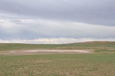
The soils of piedmont dry grasslands of Baikal region are widespread on Olkhon Island, the adjacent area and in the southern part of the basin (pic. 2.2.5). The formation of dry steppe landscapes with chestnut soils is related with arid mountain zonality. Lack of precipitation is exacerbated by high water permeability of loamy soils. Low bio-productivity is a consequence of the extreme natural-climatic conditions. Agroecosystems are in the state of crisis here while the vegetation cover degrades.
Pic. 2.2.5 The dry grasslands
The high-mountain part of the Khamar-Daban, Muysky, Verkhneangarsky and Barguzinsky ranges the main types of soil are petrozems, peat-lithozem. Hard-humus, humic and humic-dark humus soils are formed underneath sub-Alpine meadows. Brown gley soils are formed on the northern slopes in relatively lowered parts of relief and the sections composed of soil-forming elements of heavier granulometric composition.
Kryozems (hard humus), peat-kryozems are well-developed in the zone of bald mountains, being located in a comparatively narrow strip close to the upper margin of the forest. Soils of taiga area have frequently zones of permafrost as well as seasonal permafrost, kryoturbation phenomena and soilfluction.
The structure of soil cover in mountain-taiga zone is heterogeneous and is related with vertical zonality, slope exposition and permafrost. The major types of soils are brown soils, ashen-grey soil, sod-ashen-grey soil, sod-brown soils, grey humus, humic and other soils. The upper part of taiga belt is dominated by kryozems and brown soils, followed by peat –lithozems. Mountain taiga has steppe “islands” with the soils of black humus earth. They can be found on the abrupt slopes of southern exposition, facing wide sections of intermountain depressions.
The steppe zone is dominated by grey metamorphic soils, formed on the foothill parts of depressions and northern slopes of hills inside intermountain depressions or lower parts of deforested slopes, facing steppe depressions. Most of the territory is occupied by these soils in the southern part of Selenginsky uplands. The forest and steppe belt of light coniferous and grass facies can have dark humus metamorphosed soils found mainly on the southern slopes of hills. Grey humus soils were formed on carbonate rocks under the vegetation cover. This combination of soils, inherent to different ecological conditions is the main property of the soil cover at the juncture of taiga and steppe.
In the steppe landscapes of Lake Baikal basin soil cover is represented mainly by black humus soil. It is formed under the meadow steppes. The main portions of these soils are located in Tugnui-Sukharinskaya depression – on Tugnuisky range and southern slopes of Zagansky range, northern slopes of Kudarinskya mountain chain, Minor Khamar-Daba, Monostoiskiy, and Borgoisky ranges. In the north, black humus soil is formed in disparate spots on the north-western slopes of Unegetei range and the Uda and Itantsa river valleys.
The soil cover of dry steppe area is dominated by chestnut soils. They take up a vast territory of Udinsky, Priselenginsky and Borgoiskaya steppe, wide and flat terraces widespread on the southern slopes of hills. The watershed of high ridges can have lithozem soils. On the aeolian deposits of sand of the dry steppe zone, particularly in the areas between the Selenga and Chikoi rivers and Chikoi and Khilok rivers, humus psammozem soils are formed.
Soils of river valleys in the basin are represented mainly by alluvial humus-gley soils, peat-gley soils, dark humus, grey humus and dark humus quasi-gley soils. Within the structure of the soil cover of the upper and middle reaches of the rivers, alluvial layered soil can be found. In steppe and particularly in the dry steppe zone of Baikal region, saline soils and sodium soils are formed in river beds. They are found mainly in the lake depression and lower parts of flat slopes, adjacent to the flood plains where the zone of accumulation of water flow enriched with dissolved salts or the emission of mineralized ground waters to the surface. The most widespread types of salification include sulphate-sodium, sodium-sulphate, sulphate and chloride-sulphate.
Vast areas of saline soils are widespread in Borgoiskaya steppe and lake depressions of Verkhnee and Nizhnee Beloe lakes. Their role is rather significant in Ivolginskaya depression. Also saline forms of relief are observed in the lake depressions of Bichursky district and Tugnui steppe. The Selenga river delta, the Barguzin and some other large portions of land are taken by swamps where peat eutrophic and peat eutrophic gley soils are shaped.
Soils of swampy meadows and lake-wetland complexes are formed in fluvial plains on elevated places, in deltas and the progression cones of temporary water flows (pic. 2.2.6). Alluvial gley soils are formed under the conditions of additional humidity. The elevated parts of mountain rivers on the sand and pebble deposits have alluvial grey humus and layered soils. Alluvial peat-gley (peat mineral) soils are shaped in relatively low locations of river bed under the conditions of lengthy surface and ground moistening as well as on the fringes of the water bodies overgrowing with wetland vegetation. Humus-hydrometamorphic soils are shaped in the central plain of rivers. The lake part of the depression havs predominantly hydrometamorphic permafrost soils.
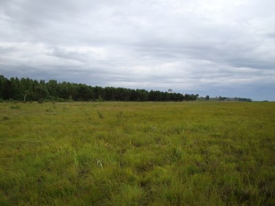
Pic. 2.2.6 Swampy meadow in the Selenga River delta
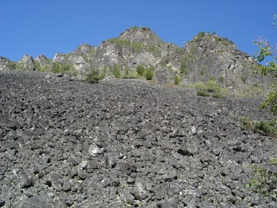
Soils of the basin are subject to destructive processes: wash-away, erosion and deflation (pic. 2.2.7) [3,4]. As a consequence of these processes the loss in harvest production is annually 15-20 %. Agrohydrological properties of soils are determined largely by their mechanical composition. The greatest amount of productive dampness is characterized by sandy soils (90-105 mm). Following an increase in the concentration of smaller fractions, the amount of productive dampness rises reaching 160-190 mm for light loamy soils and 215 mm for heavy loamy soils. The coefficient of water-yielding capacity is around 65-75%.
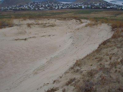
Pic. 2.2.7 The deflation
According to observation data, in spring the reserves of productive dampness in the meter-deep layer of soil is on the average 80 mm, for sandy soils and for loamy soils it is 100 and 160 mm, respectively. In summer, in July and August, they shrink for sandy soils up to 60 mm and for loamy soils up to 100 mm. Due to the low concentration of productive dampness in the soils of light mechanical composition and their insufficient moistening in the vegetation period, the acquisition of stable harvests is only possible through irrigation. Of great significance are agrotechnical devices aimed at preserving dampness in soil and the protection of soil from water and wind erosion (pic. 2.2.8).
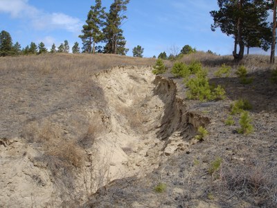
Pic. 2.2.8 The water erosion
The reduced anthropogenic impact on ecosystems of the Lake Baikal basin during the last decade contributes to the restoration of natural landscapes and the lowered rate of aridification. Therefore, desertification is not observed within the Russian part of the basin, in contrast to Mongolia [23].
Scientists have identified 34 types of soils in Mongolia. The most common type of soil - brown soil - comprises 40.4% of the total territory, of which 22.6% is located in mountainous areas and 17.8% is in plain areas (pic. 2.3.2). The brown soil is further classified into three sub-types, including dark brown, genuine brown and light brown soil. The most widespread is dark brown soil (17.6%), followed by genuine brown soil (11.9%), and light brown soil (10.9%) [15].
The Law on Soil Protection and Prevention of Desertification introduced a classification of the extent of soil degradation and desertification, categorizing it as «weak», «medium» and «strong» [16]. «Weak» extent of soil degradation implies that less than 5% of the soil is polluted or eroded; «medium» extent of degradation implies that 5-20% of soil is polluted or eroded; and «strong» extent of degradation implies 20-50% of soil is polluted or eroded.
In Mongolia, precipitation increases from the central part to the north following the changing relief and climate, and steppe landscape is replaced by meadow-steppes, meadows, swamps, forests and taiga-forests. In the mountainous region in the north of the country, the soil moisture is relatively higher due to more precipitation as well as humidification by big and small rivers and multi-year permafrost.
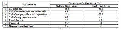
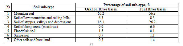
In the wide valley between the Khangai and Khentii mountain ranges, arid plain soil and desert-plain soil are spanning till the Tagna mountain range. Arid-steppe brown soil covers a significant area of the valleys located in Orkhon-Selenge basin. The Orkhon and Tuul river basins have mountain dernotaiga soils, low mountain chestnut soils, steppe valley brown and dark brown soils, while meadow and river valley soils are dominant (table 2.2.1).
Table 2.2.1 Percentage of soil sub-types in the Orkhon and Tuul river basins
The extent of land degradation can be defined as «weak» for 35.3% of lands, «medium» and «strong» for 25.9% and 6.7% of lands, respectively (pic. 2.2.9) [17].
Pic. 2.2.9 The soil degradation
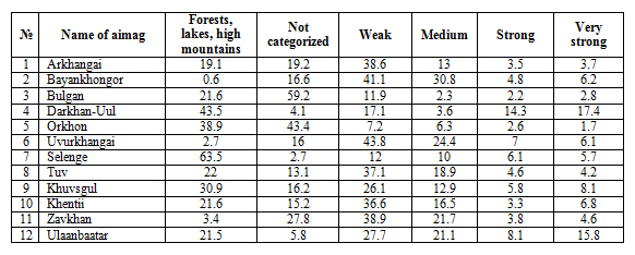
The desertification maps created by Geoecological Institute of Mongolian Science Academy in 2006 and 2010 were compared, and it was revealed that distribution of the areas with «strong» desertification changed during the period, i.e. numerous new desertification hotspots have formed [15]. For instance, new desertification hotspots were observed in the north of Bayankhongor aimag and Orkhon river basin. However, along the border of Uvurkhangai and Dundgobi aimags the area of lands affected by desertification have reduced (Table 2.2.2).
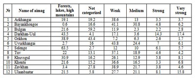
Table 2.2.2 Extent of desertification in the aimags within the Selenga River basin (%)
Increased logging, forest fires, vegetation damage by pests, mining (mineral extraction) and unauthorized tree-cuttings cause imbalance in forest ecosystems and facilitate desertification processes. The Law on Soil Conservation and Prevention of Desertification approved by State Great Khural in 2012 established incentive measures for individuals and organizations conducting soil conservation and desertification prevention activities (pic. 2.2.10).
Pic. 2.2.10 The hotbed of desertification
Document Actions
2.3 Vegetation
2.3 Vegetation
The territory of Lake Baikal basin is part of the forest-steppe and forest taiga zone [3,4]. However, a considerable degree of territorial disintegration and the presence of intermountain depressions determined vertical zonality in the distribution of the vegetation cover. Within the area of the basin the following belts are distinguished: steppe, forest-steppe, mountain-steppe, goltsy-forest with cedar shrubs and goltsy belt.
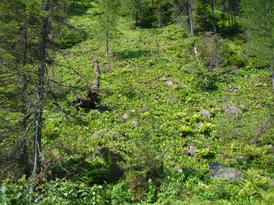
Goltsy belt stands out clearly on the ranges of Baikal mountain chain. The height of the lower level of the belt varies from 1100—1500 m in the north to1600—2000 m in the south. The goltsy belt is dominated by high mountain and wilderness landscapes. Vegetation of high mountain wilderness is represented by sparse low heather grass and lichen as well low heather shrubs. A characteristic feature of the goltsy belt is wide distribution of stone placers without vegetation (pic. 2.3.1). Comparatively small areas embrace portions of mountain tundra with shrub-lichen and small shrub-lichen vegetation. Barguzinsky range is abundant in the areas with mountainous sub-Alpine meadows (in the lower part of goltsy range). They do not constitute considerable land mass but alternate with the sections of mountain rocks and cedar forests, being located on the bottom of kar and in the upper part of trough valleys. Mountain meadows are characterized with dense and high grass (up to 40-60 cm) consisting of aquilegia, anemone and other species. Among sub-Alpine meadows one can observe portions of sedge-sphagnum and sedge wetlands.
Pic. 2.3.1 Goltsy belt of vegetation, Barguzinsky range
Belt of goltsy forest and cedar shrubs is found above mountain taiga at the elevation of 1000-1500 m in the north and 1500-2000 m in the south. It takes comparatively small territory on the mountain ranges having flattened contours and flat tops, rising above the upper boundary of the forest. The mountain slopes are covered by cedar forests with a height from 0.5 to 2 m and goltsy sparse forest on the flattened sides. The latter is a sparse and depressed larch and cedar-larch forest with cedar shrubs, dwarf birch and other shrubs (pic. 2.3.2). The soil cover is dominated by lichen and occasionally moss (pic. 2.3.3). In some areas, where considerable and stable inversions of air temperature are observed, goltsy forests are found within the mountain-taiga belt (on the northern slopes of mountains, facing narrow shadowed valleys, on river and lake terraces.
Pic. 2.3.2 Belt of goltsy forest and cedar shrubs on the Khamar-Daban range
Pic. 2.3.3 Lichens on the Barguzinsky range
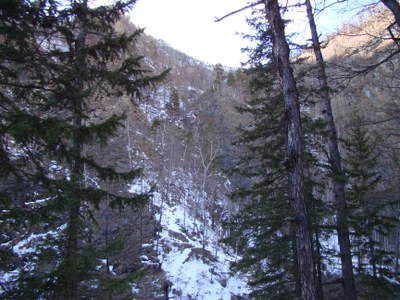
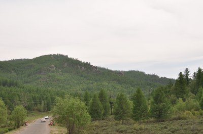
Mountain taiga is the most widespread landscape on the considered territory [3,4]. It takes up to about 70% of the Russian part of Lake Baikal basin and constitutes a bulk of its vegetation cover. The mountain taiga is mainly comprised by coniferous trees – Dahurian and Siberian larch as well as pine, cedar and in rare instances silver-fir and fir-tree. Of deciduous trees the most widespread species are birch and aspen. Depending on the latitudinal position of the place, the mountain-taiga belt occupies different altitudinal position. In the north, in the Verkhnyaya Angara basin, taiga is situated at an elevation of 460-600 to 1000-1500 m, and in the south at an elevation of 1000-1400 to 1500-1800 m. Along the coast of Lake Baikal, the lower boundary of taiga runs till the edge of water. The altitudinal position of the upper boundary of taiga depends on the exposition of mountain slopes. On the western slope of Barguzin range, facing Lake Baikal, the upper boundary of the forest is located at an elevation of 900-1400 m and on the better warmed eastern slope rises to 1400-1800 m.
Mountain-taiga zone is divided into three altitude belts, corresponding to the southern, middle and northern taiga. Southern taiga is located to the south of 52° N below 1100-1200 m. It includes sparse larch-pine and pine forests with addition of birch. The underbrush is sparse and is dominated by dahurian rhododendron and spiraea. The soil cover incorporates shrubs and grass (pic. 2.3.4). Middle taiga is most widely spread. The major kind of tree is larch, other important species include pine, cedar and birch. In some portions, especially on the slopes of hills facing Lake Baikal, aspen, silver fir and fir can be found. The stand of trees is rather sparse, the underbrush is well developed and includes dwarf birch and dahurian rhododendron. The soil cover includes dense shrubs of red bilberry, blueberry and foxberry. Moss can also be found but it does not form a continuous cover.
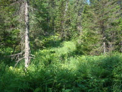
Pic. 2.3.4 The mountain taiga, the Khamar-Daban range
The composition of tree stand and underbrush changes depending on the slope exposition. Northern slopes have sections with depressed tree stand and dense underbrush of alder and cedar with a continuous moss cover. On the southern slopes, the tree stand is always better, pine tree is widespread, grass and shrubs are dominant in the soil cover. The belt of northern taiga is characterized by sparse and depressed tree stand, consisting of larch with the mixture of cedar. The underbrush always has cedar and dwarf birch trees as well as small-leaf rhododendron and alder. The grass and shrub layer includes wild rosemary, blueberry, red bilberry and sedge. The soil cover is dominated by moss while flat water-divide mountain tops have sphagnum. Forests in the mountain taiga zone protect soils from being washed away during snow melting and summer rain floods. Taiga protects soil from wind erosion, exerting a great impact on the conditions of snow cover formation. On the abrupt slopes, taiga reduces the risk of avalanches taking place.
Forest-steppe areas are usually bounded by the places with steppe vegetation (pic. 2.3.5). Baikal forest and steppe zone is commonly characterized by the alternation of steppe sections, lying on the southern slopes of mountains, with the deforested sections on the northern slopes [3,4]. The forest and steppe zone does not form a continuous belt and consists of disparate portions separated by mountain-steppe and mountain-taiga vegetation clusters. The sections of forest-steppe vegetation are located at an elevation of 900-1200 m. Forests of this belt are primarily sparse and are made up of pine, larch and birch; the underbrush is weakly developed or is gone. Steppe and forest-steppe areas are widely used in agriculture as plough lands, hay-making ground and pastures.
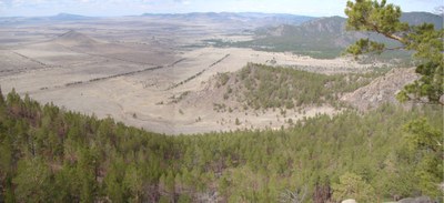
Pic. 2.3.5 The forest-steppe, Valley of Tugnui River
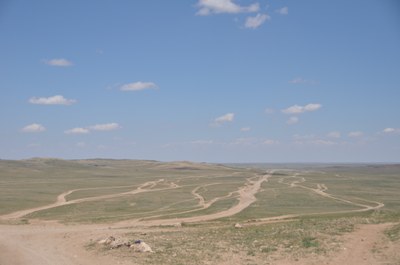
Steppes do not form a continuous landmass but incorporate separate sections, related with tectonic depressions and river valleys [3,4]. Two groups of formations are clearly distinguished – steppes of mountains and steppes of foothills, elevated plains and hummocky topography. In each of them one can distinguish two large ecological-morphological groups – meadow and dry steppes. For each of such groups one can distinguish separate regional steppe complexes – South Siberian, North Mongolian and Central Asian formations (pic. 2.3.6).
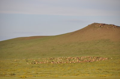
Pic. 2.3.6 The North Mongolian steppe
The upper border of the steppe does not rise above 900-1100 m. Dry steppes with hazel soils are characterized by the presence of low plants (average height is from 10-15 to 25-35 cm) and sparse density (with the project cover of 60-70%). Black humus soils have steppes with different herbs characterized by denser and higher grass level. Steppe plants have well developed root systems reaching the depths from 10 to 70 cm. Vegetation groups are quite diverse. Of gramineous plants, the most widely spread plants are mat-grass, cleistogenes, sheep fescue, meadow grass, and june grass [4,18]. Of wild grasses, widely present ones are tansy, potentilla, oxytrope, astragal, sedge, wormwood, pea shrub, etc. Saline soils typically have jiji grass and flag-leaf as well as salt grass and saltwort (pic. 2.3.7).
Pic. 2.3.7 The area of salinity in the Mongolian steppe
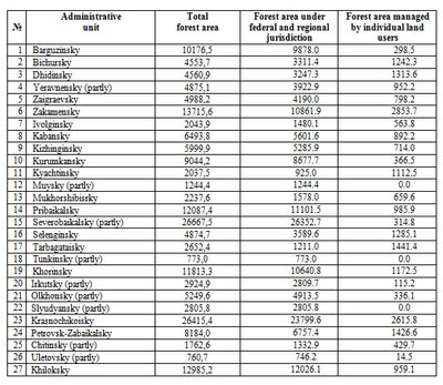
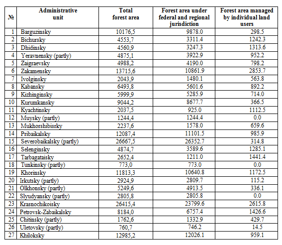
Forests. The total area of forested land within the Russian part of the Lake Baikal basin is 191982.5 km2, of which 169118.7 km2 is under the jurisdiction of the federal government and 22863.9 km2 is managed by individual land users (data of the digital topographic basis of BINM SB RAS) (табл. 2.3.1).
Table 2.3.1 Forest area within the Russian part of the Lake Baikal basin by administrative districts, km2
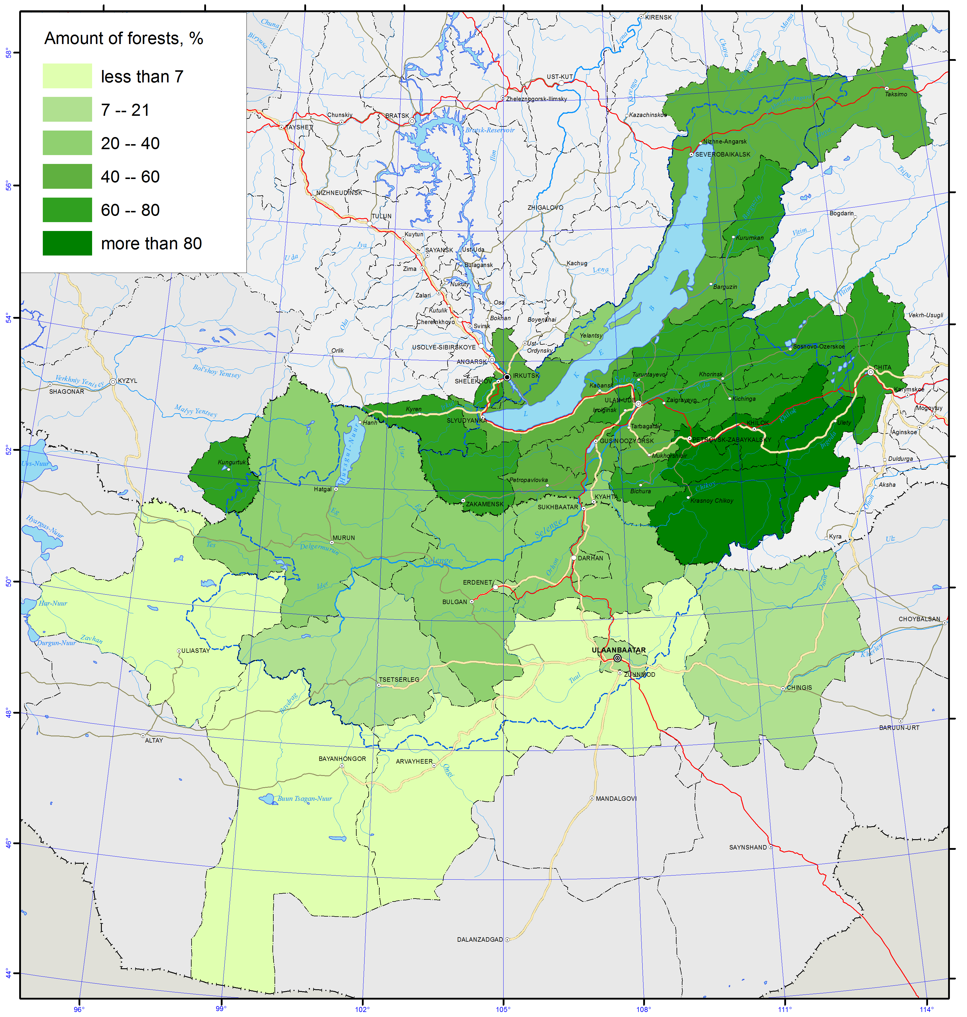
The total area of lands covered by forests in the Republic of Buryatia, including forest fund lands and other land categories, was 29638.4 thousand ha or 84.4 % of the total land area as of 01.01.2013 (pic. 2.3.8) [4,7].
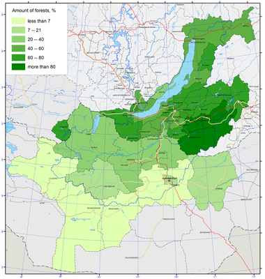
Pic. 2.3.8 Amount of forests of Lake Baikal basin [1]
The Republic Forest Agency is responsible for supervising the forests of the forest fund with the total area of 27010.3 thousand ha or 91.1% of the entire forest lands in Buryatia. In terms of use, forests are divided into 3 major categories: protected forests occupying 9308.1 thousand ha, exploited forests occupying 9436.4 thousand ha, and reserve forests occupying 8265.8 thousand ha.
Forests, not included in the forest fund, are the forests located on lands of other categories: forests located on the specially protected natural territories affiliated with the Ministry of natural resources and ecology of the Russian Federation – 2065.1 thousand ha (7% of all forests); forests, not included in the forest fund of the republic, are represented by the lands within human settlements with a total area of 29.6 thousand ha (0.1% of the forests), lands of other categories (lands of the water fund, land occupied by industries, reserve lands) with a total area of 85.1 thousand ha (0.3% of all forests) [7].
Mongolia’s forests are located in the transitional zone between the great Siberian taiga and the Mongolian plateau of grassland steppe (pic. 2.3.9). These forests play a critical role in preventing soil erosion and land degradation, in regulating the water regime in mountain areas, maintaining permafrost distribution, providing habitats for wildlife and preserving biodiversity. Even though Mongolia is a country with limited forest resources, there are more than 140 species of trees and shrubs and forests cover 12.9 million ha, which is about 8.2% of the total area of the country (pic. 2.3.8). According to the Law on Forestry approved in 2012, the lands already covered by forest and required for forest extension are determined as the forest fund [18,19].
Pic. 2.3.9 The coniferous forest in Mongolia
Forests are classified as strictly protected forests, protected forests, and utilization forests (pic. 2.3.10). Utilization forests are designated primarily for commercial timber harvest with contracts and the payment of fees required. The strict zone forest consists of sub-alpine forests, pristine and conservation zone forests within strictly protected areas, and special zone forests within national conservation parks.
The protected zone category is much broader, consisting of four sub-zones including certain forests within specially protected areas - national conservation parks, nature reserves, and monuments - as well as green zones around towns and villages, prohibited strips along riparian zones, national roads, and railways, and locally protected forests (pic. 2.3.10). Locally protected forests may consist of areas containing different forest types, including saxaul forests, oases, forest stands covering up to 100 hectares, forest groves, shrubs, sun-exposed forest areas, and forests on slopes steeper than 30 degrees.
Pic. 2.3.10 The locally protected forest
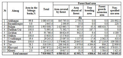
By 2012, the total area occupied by Mongolian forest fund was 18 592.4 thousand ha, of which 12 552.9 thousand ha were covered by forests. 75.4% of the total forest fund area is covered by coniferous and deciduous forests (pic. 2.3.11) and 24.6% by saxaul forests. 15.3 million ha of the forest fund area is the protected forest zone, and 10.8 million ha of this zone are covered by coniferous and deciduous forests and 4.5 million ha by saxaul forests. Every year the Government Implementation Agency reports the total forest fund area by administrative regions based on information from Geodesy and Cartography Agency and National Statistics Committee (table 2.3.2) [18,19,20].
Pic. 2.3.11 The forest on Lake Khuvsgul
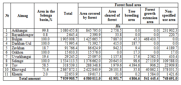
Table 2.3.2 Forest fund area in aimags within the Selenga river basin (2013)
The Selenga River basin in the northern part of Mongolia is covered by mixed forests (pine, larch, and cedar) and grassy plants (pic. 2.3.13). During the summer of 2013, Ministry of Environment and Green Development conducted a research expedition to catalogue endangered and beneficial plants. The expedition covered 17 aimags and various natural zones - forest steppe, steppe, and semi-desert steppe. The researchers have found and recorded 188 species of beneficial and 70 species of endangered plants growing in Khovd, Gobi-Altai, Uvurkhangai, Bayankhongor and Umnugobi aimags and 54 species endangered plants in Selenge, Orkhon, Bulgan, Arkhangai, Zavkhan and Tuv aimags. Among all these endangered plants, 23 were found and recorded in Khangai region.
According to the Mongolian vegetation list, there are more than 2 800 plant species in the country [19]. Among them, 382 species of plants can be used for food and drug manufacturing (pic. 2.3.12), 195 species of them need to be protected. Researchers have presented a list of 102 plants that have commercial value and recommended the ways the plants could be used. Ten species, such as licorice, ephedra, etc., are liable to illegal plant trade, eight more species were added into Mongolian endangered plant list, and 37 species require to be further inspected.
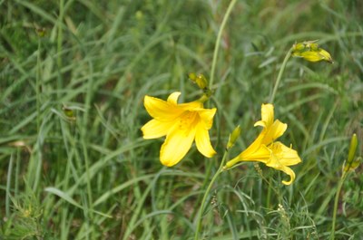
Pic. 2.3.12 Hemerocallis minor, the upper river Tuul
In Mongolia, there are 75 endangered species of medicinal plants, 20 species of which are on the brink of extinction [21]. Furthermore, in danger of extinction there are 11 species of food plants, 6 species of which are on the brink of extinction; 16 species of technical plants; and 55 species of ornamental plants, 5 species of which are on the brink of extinction.
Document Actions
2.4 Animal world
2.4 Animal world
A considerable number of natural landscapes in Lake Baikal basin determine a great diversity of animal species there. The region has 446 vertebrate species, including:
- 348 bird species of 18 orders (4% of the world avifauna);
- 85 mammal species of 7 orders (23% of the world theriofauna);
- 7 vermigrade species of one order (0.1% reptiles of the world);
- 6 amphibian species of 2 orders [3,4,22].
Mongolian fauna consists of 138 species of mammals, 75 species of fish, 22 species of reptiles, 6 species of amphibians, 472 species of birds, 13 000 species of insects, 516 species of mollusks and protozoa [21].
On the Russian territory of the basin, brown bear (Ursus arctos) inhabits the coastal and northern districts, large forests, in particular, in Eastern Pribaikalie and the Khamar-Daban (pic. 2.4.1) [3,4]. Among different habitats it prefers cedar forests. The brown bear is dormant in winter, digging lairs on dry slopes with sandy and sabulous soil, sometimes under rocks. He starts hibernation in the latter half of October, usually before the first big snow and leaves the lair in April or May. The oestrum period is in June or July, cubs are born in January-February. The number of cubs is1-3, most commonly 2. It feeds on vegetation and animal food. In the years of poor harvest of berries and nuts, insomniac bears may wander around. The bears wander alone on an area of about 70-400 km2. The number of brown bears is growing at present – from 2690 animals in 2001 to 4878 in 2010.
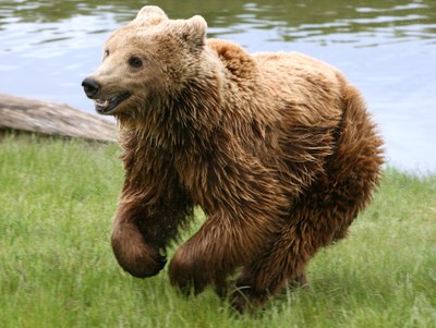
Pic. 2.4.1 The brown bear
By taxonomic parameters, the reindeer (Rangifer tarandus) inhabiting the Russian territory of the basin, is identified as Rangifer tarandus (pic. 2.4.2) [3,4]. Today, reindeers dwell in the disparate sections of mountain areas, including Ulan-Burgasy, Ikatsky, Barguzinsky, Severobaikalsky, Vitimsky and Muysky mountain ranges. Since the reindeer inhabits isolated and remote places, the assessment of the present-day number is based not only on the data of winter route tracking, experts emphasized gathering survey data from forest managers of natural protected territories and hunters. The number over the last five years was 16-19 thousand animals. The results of the winter route tracking in 2012 revealed the number of 18417 animals, which is in agreement with the assessment by forest managers and hunters.
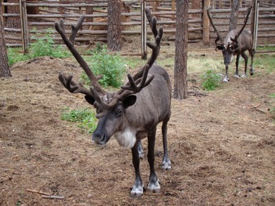
Pic. 2.4.2 The reindeer
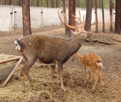
Red deer (Cervus elaphus xanthopygus) migrates seasonally from the zone of bald mountains to the foothills of mountain ranges, concentrating in the area of little snow with ample fodder reserves and minimal disturbing factors (pic. 2.4.3) [3,4].
Pic. 2.4.3 The red deer
According to the assessment of forest managers, the lengthy and high snow cover in the winter period of 2010-2012 caused forced migration of the red deer to the hitherto uncharacteristic areas of little snow, more favorable habitats (pic. 2.4.4). Thus, forced migration of the red deer led to the growth in number of intersections on the permanent routes, which impacted the winter route tracking assessment in 2011-2012 and made it difficult to assess the number of animals.
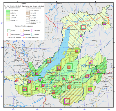
Pic. 2.4.4 Hunting resources [1]
The bore (Sus scrofa) is widely spread on the Russian territory of the basin (pic. 2.4.5) [3,4]. The distribution areal of the bore has been influenced by agricultural practices. The poorly harvested crops in some areas produced a good fodder basis for the bore and allowed it proliferate in the hitherto less available places. In the dynamics of the last ten years the number of bores rose from 4 to 8 thousand animals. At present, the number tends to grow and according to the 2012 data the number of bores is estimated at 8508.
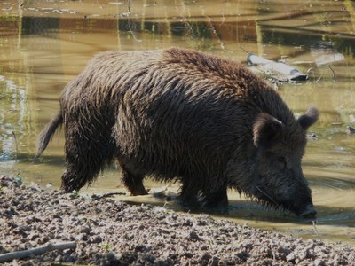
Pic. 2.4.5 The bore
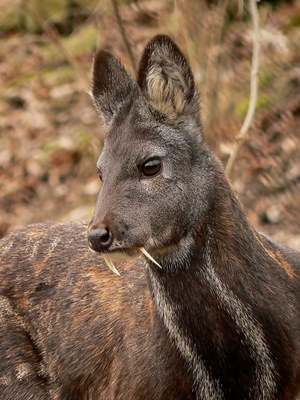
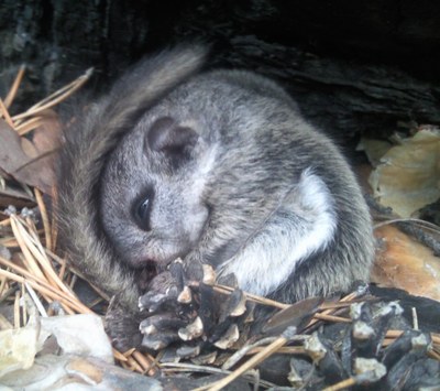
Musk deer (Moschus moschiferus) was listed by the International Union for Conservation of Nature (2003) as an «endangered» species due to the considerable amount of international trade in products derived from it (pic. 2.4.6) [3,4]. Considering these circumstances, the counting of musk deer is conducted based on the methods adapted to the biological peculiarities of this animal. According to the winter route tracking of 2012, the number of musk deer was 16.4 thousand animals, which is higher than the average long-term number over the last ten years. These data suggest stability in the number of animals, even though the musk deer population is affected by forest cutting and frequent forest fires.
In Mongolia found in Khentii, Khuvsgul, and Khangai mountain ranges, some mountain forests in the southern part of Mongol Altai.
Pic. 2.4.6 The musk deer
Siberian roe deer (Capreolus pugargus) is the most widely spread animal among large mammals in Buryatia (pic. 2.4.7). The area of distribution covers the whole territory of the Russian part of the basin. In spring, following the boundary of snow melting roe deer migrate from valleys to mountains and elevated wetlands, which serve them as protection, providing less sources of disturbance and simultaneously a good fodder basis and ample water sources [3,4]. Thus, watershed ranges provide home not only to the roe deer, but also all the hoofed animals. In autumn, starting from the end of August, roe deer migrate to their winter habitats in small groups of 2-4. Migration is usually started by females with calves born in the year, while males migrate later on. The period of autumn migration is usually from September to December, and spring migration is from March to May. According to the assessment of 2012, the number of roe deer was 42873 animals.
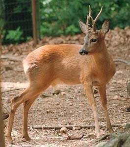
Pic. 2.4.7 The Siberian roe deer
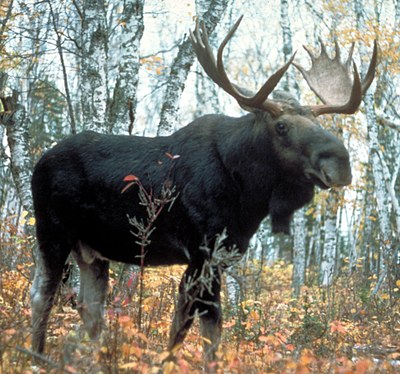
The territory of the basin is the habitat of one of the four biggest mammals in the country – East Siberian elk (Alces alces) (pic. 2.4.8). Seasonal migrations of the elk are determined by the availability of fodder [3,4]. The habitat of elk is usually dominated by young coniferous forests, pine, larch, aspen trees and elks particularly tend to dwell in burnt-out places, in the thickets of low-height birch, shrubs, meadows and river valleys. In summer, life of the elk is closely related with lakes and rivers. In addition to the availability of fodder, the areal distribution of elk is also determined by snow cover and anthropogenic impact. The number of animals over the last ten years varies from 6 to 8.5 thousand animals, which has to do with the above mentioned biotic and abiotic factors. According to 2012 assessment, the number of elks in the republic was 7851 animals. Widespread in northern Mongolia
Pic. 2.4.8 The elk
The territory of the basin is home to squirrel (Sciurus vulgaris), which inhabits mountain larch forests of Dahurian larch as well as cedar, pine and larch-pine forests (pic. 2.4.9). The dynamics of squirrel number over the five years varies within 145-170 thousand animals [3,4]. According to the data of the winter route tracking in 2012, the number of squirrels was estimated at 161.6 thousand animals. The number tends to fluctuate in cycles depending on solar activity and the fodder productivity.
Pic. 2.4.9 The squirrel
Dynamics in the number of mountain hare has a cyclic character with the decade-long growth cycles (pic. 2.4.10). The major causes influencing the reproduction of the species are climatic conditions in spring-summer period, having to do with the birth of the young and their first days of life [3,4]. The dynamics of the species within the last ten years vary within 37 to 95 thousand animals. According to the assessment of 2012, the number of mountain hare showed a decreasing trend and was estimated at 43.5 thousand animals, which is higher than the figure for 2011, yet lower than for the previous 5years.
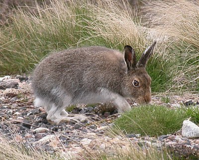
Pic. 2.4.10 The mountain hare
The habitat of sable (Martes zibellina) on the territory of the basin is cedar forests on the stony soil, cedar elfin wood, old burned places with coniferous and deciduous trees, larch-fir and pine-cedar forests with stony deposits (pic. 2.4.11). The number of sable over the last ten years has varied considerably across years. According to the assessment of 2012, the number of animals was 22.5 thousand, which is about the same for the preceding year [3,4]. In the winter period, both in 2011 and 2012, there were no signs of considerable vertical migrations of sable. Considering the ten-year dynamics, the number of sable in 2012 remained above the average level.
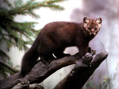
Pic. 2.4.11 The sable
Ermine (Mustela erminea) inhabits mountain-taiga, forest-steppe biotopes, on stony deposits. Forest cutting is advantageous for the ermine [3,4]. However, it has been clearly identified that in dark coniferous forests and pure cedar forests ermine is rarely observed. It is virtually not to be found in the area with the high concentration of sable. Within the last ten years, the number of sable has varied from 9 to 15 thousand animals which is typical for fur-bearing animals. According to the 2012 assessment, the number of ermine is estimated at around 10 thousand animals, which is higher than their number in the previous 2 years.
Siberian weasel (Mustela sibirica) is widely spread [3,4]. In taiga, forest-steppe and mountainous areas it can be observed in the river valleys, brooks, stony deposits, overgrowing burned places, river banks and shores of lakes and shrubs. It can be seldom found in dark coniferous forests and mixed taiga, as its main competitor here is the sable. It does not dwell on barren mountains and dry steppes. According to the state monitoring, the number of Siberian weasel was 7310 in 2012, which is above the level for the previous four years. There is no specifically organized hunting of the weasel, as the reproduction of weasel runs in parallel with the reproduction of other animals.
Fox (Vulpes vulpes) is spread across the whole territory of the basin, however, the distribution is uneven [3,4]. During the ten years preceding 2012, the number of foxes has risen, particularly in the last three years, reaching 5290 animals in 2012. The amount of production through hunting also varies from 100 to 800 animals, which is explained by the high demand for the fur on the market and price politics. Due to shrinking demand and low purchasing cost for the fur over the last four years, the amount of production dropped and averaged at no more than 200 animals per year.
The wolf (Canis lupus) is widely distributed, inhabiting all the districts of the basin. In the course of many years, the state authorities of the Buryat Republic have taken measures to regulate the population of wolves [3,4]. On average, the amount of production was 300-400 animals annually during 1995-2005. In 2006-2007, the amount dropped to110-140 animals. In most cases, guns are used for hunting. According to the assessments, the number of wolves was 2517 animals at the beginning of 2012, which testifies to the efficiency of regulation measures. At the same time, some further regulation measures are required, considering frequent migrations of wolf packs from the neighboring regions and Mongolia, to reduce possible damage to agriculture and hunting grounds.
The state of lynx (Felis lunx) habitat in the region can be considered satisfactory [3,4]. The most typical landscape habitats include mountains, pine and larch forest-steppe, pure and mixed forests, lowlands on the slopes of hills, sometimes intersected by cut or burned area, where young aspen and birch trees grow. During the last ten years, the number was stable and varied from 630 to 1300 animals. In 2012, the number of lynx was estimated at 1258, which was higher than for the previous year but about the same as during the preceding six years.
The distribution area of Siberian marmot (Marmota sibirica) on the Russian part of the basin is 32.3 thousand ha [3,4]. There are around 20-30 thousand marmots. The number of animals may vary. Spring counting of 2012 was conducted on the territory of steppe and forest-steppe districts of the republic, where the number of marmot was estimated at 20166.
Wild Przewalski's horse (Equus ferus przewalskii) that inhabits semidesert steppe and steppe. Found in Hustai mountain range located in Altanbulag soum of Tuv aimag (pic. 2.4.12) [23].
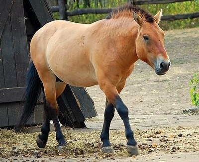
Pic. 2.4.12 The Przewalski's horse
Birds are the most diverse group of fauna on the Russian part of the basin [3,4]. Of 348 species, 260 are breeding birds, 34 are birds of passage, 7 wintering, 1 is flying and 46 are vagrant.
Grouse as a typical forest bird, leading a secluded way of life and spending most of the time, especially in summer, on land. In the period of collecting gastorolites, when the birds come to the sand bars and roads, grouse is rarely found. The number of grouse in the republic is recovering now after the forest fires of 2003-2004 and was estimated at 150.5 thousand in 2012. The winter period of 2012 was good for the grouse and it did not affect the number and reproduction conditions of the bird.
According to the assessment of 2011, the number of black grouse reached 311.8 thousand [3]. According to the state monitoring data, there were 252.7 thousand animals in 2012, which is comparable to the level of 2009-2010 and can be considered as the most plausible estimation. The analysis revealed that black grouse hunting is of little significance in the republic and the bird is hunted simultaneously during hunting for other animals. Overall, thanks to the favorable conditions during the last five years, the number of black grouse rose significantly.
Hazel grouse is a typical forest bird leading a secluded way of life and spending most of the time on the land. The number of the bird is subject to cyclic fluctuations. Based on the assessments of 2004, 2006 and 2008, the number of hazel grouse has been on the decline and was estimated to be one thousand birds. According to the same assessment, the number of hazel grouse rose in 2009-2012. Hazel grouse hunting is not practiced, it is concurrently done while hunting fur-bearing animals. The exception is hunting with the use of the call.
Dahurian partridge is sedentary species making short-distance and non-regular migratory trips [3]. The number of partridge has been declining during the last 3 years after reaching its maximum in 2009. According to the state monitoring of 2012, the number of Dahurian partridge was 78.4 thousand. The number has been about the same during the last 15 years.
Short-toed snake-eagle (Circaetus gallicus). Found in the west-south part of Khentii mountains during reproduction period. Generally inhabits Selenga river valley. During summer and laying of eggs, mostly found in Umnugobi aimag, Gobi desert (pic. 2.4.13) [23].
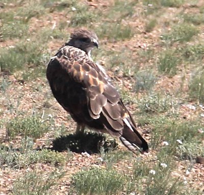
Pic. 2.4.13 The short-toed snake-eagle
Greater spotted eagle (Aguila clanga). A scarce summer visitor and passage migrant, presumably breeding in the taiga and/or forest-steppe of northern Mongolia. Was recorded in Khentii mountains and taiga or forest-steppe area along the Selenga river, in Zavhan, Bulgan, Arkhangai and Tuv aimags [23].
Pallas's Sea(fish)-Eagle (Haliaeetus leucoryphus) Found along banks of rivers and lakes. Have been spotted near the lakes Khuvsgul, Achit, Khar Us, Khar, Dorgon, Hyargas and Uvs, and the basins of the rivers Zavkhan, Kharaa, Tuul, and Orkhon [23].
Bibliography
- Ecological atlas of the Lake Baikal basin – Irkutsk: Institute of Geography SB RAS. 2014. http://bic.iwlearn.org/ru/atlas/atlas
- Garmaev E.Z., Khristoforov A.V. Water resources of the rivers within Lake Baikla basin: basis for their use and protection. Novosibirsk: “Geo” Academic Publishing, 2010. 231 pp.
- State report “On the state of Lake Baikal and measures for its conservation in 2012” - Irkutsk. Siberian branch of “Rosgeolfond”, 2013. - pp. 436. http://www.mnr.gov.ru/regulatory/list.php?part=1258 (in Russian)
- State report “On the state of Lake Baikal and measures for its conservation in 2013” - Irkutsk. Siberian branch of “Rosgeolfond”, 2014. - pp. 462. http://www.mnr.gov.ru/regulatory/list.php?part=1258 (in Russian)
- Tulokhonov A.K., Plyusnin A.M., Namsaraev B.B. et al. The Selenga river delta – the natural filter and indicator of the state of Lake Baikal. Novosibirsk: SB RAS Publishing, 2008. 314 pp.
- State report “On the state of the environment and its proptection in the Republic of Buryataia in 2012”. http://minpriroda-rb.ru/upload/iblock/9cb/frmoytmrq2013.pdf (in Russian)
- State report “On the state of the environment and its proptection in the Republic of Buryataia in 2013”. http://minpriroda-rb.ru/upload/iblock/26b/gocdoclad_2013.pdf (in Russian)
- MEGD, «Strengthening Integrated Water Resource Management in Mongolia» project, «Integrated Water Management Assessment Report, Volume I», http://www.tuulgol.mn/dmdocuments/reports/national_report_volume1_english.pdf
- Water resource of Mongolia http://www.travelnews.mn/index.php?songolt=content&task=content_item&id=833&menu_id=579
10. MEGD, «Strengthening Integrated Water Resource Management in Mongolia» project, “Tuul River Basin integrated water resources management assessment report”, UB city 2012, http://www.tuulgol.mn/dmdocuments/reports/tuul_r_b_report_english.pdf
11. «Mongolian water forum-ushelts» NGO, «Baseline study on Socio-economic and ecological conditions of Ider river basin», UB city 2013
12. «Mongolian water forum-ushelts» NGO, «Baseline study on Socio-economic and ecological conditions of Khuvsgul lake-Eg river basin», UB city 2013.http://baikal.iwlearn.org/en/project/project-tender-reports-2012/010-eg-sub-basin-watershed-management-plan-mongolia
13. Performance report on the convention on wetlands of international importance,especially as water fowl habitator RAMSAR convention, 2012.
14. The Institute of Geography of Mongolian Academy of Science, the National Atlas of Mongolia, 2009
15. Mongolian Law on Soil Protection and Desertification Prevention, 2012.05.17, http://www.legalinfo.mn/law/details/8664?lawid=8664
16. The Environmental Information Center, Desertification database, http://www.eic.mn/DLDbase/, eic.mn/DLDbase/upload/2013/tadesertcontent/jpg/20131021_8432.jpg
17. Mongolian Law on Natural Vegetation, 1995.04.11, http://www.legalinfo.mn/law/details/76?lawid=76
18. Plant and Forest Conservation, https://mn.wikipedia.org/wiki/Ургамал_ой_хамгаалал
19. National Statistical Office of Mongolia, «Mongolian Statistical Yearbook», UB city, 2013
20. MEGD, Mongolian Red book, UB city 2014
21. Red book of the Republic of Buryatia. Rare and endangered species of animals, plants and fungi. - 3rd edition, revised and enlarged. Ulan-Ude, BSC SB RAS Publishing house, 2013, 687 pp.
22. The National Program for endangered animals and rare animals, Appendix of the resolution № 277 of the Government in 2011, legalinfo.mn/annex/details/2927?lawid=5500
23. Voloshin A.L. Geoekologicheskie osobennosti sovremennykh ekzogennykh rel’efoobrazuyushchikh protsessov mezhgornykh kotlovin Selenginskogo srednegor’ya. Avtoreferat diss. Na soiskanie uchenoi stepeni kandidata geograficheskikh nauk. – Ulan-Ude. – 2011. [The Geoecological Peculiarities of Contemporary Exogeneous Landscape Forming Processes of Intermontane Hollows of the Selenga Mid-Mountains]
