2.2 Soils
2.2 Soils
The great distance of the Lake basin from south to north determines latitudinal changes of the thermal factor and the related soil and vegetation cover. In addition to these main regularities, there is also the influence of exposition, meridional and mountain zonality. Of great significance is the role of permafrost, heterogeneity of soil-forming rocks, complex evolution of landscapes in the past and their transformation as a result of anthropogenic impact. The prevalence of mountain relief led to the domination in the region of East-Siberian mountain-taiga landscapes. A considerable part of the territory is covered with mountain taiga, while portions of grassland landscapes, associated with intermountain depressions, run far into the northern regions.
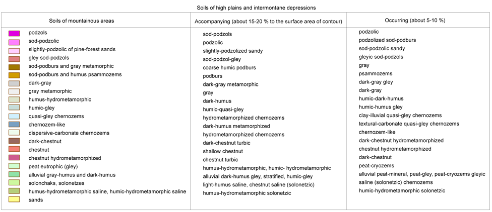
Lake Baikal basin is characterized with two types of soil: soils of mountain territories and soils of intermountain depressions [3,4]. Soils of mountain territories are thin and formed as a rule on eluvium and eluvium-deluvium of intrusive mountain rocks and to a lesser extent – on eluvium and eluvium-delivium of effusive, sediment and metamorphic rocks. Soils of intermountain depressions are formed on different loose sediments, on sandy and clay layers (pic. 2.2.1).
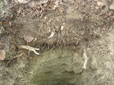
Fig. 2.2.1 Soil profile in the Valley of Verkhnyaya Angara River
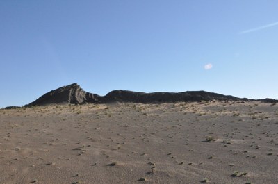
In the north of the territory, the upper part of the taiga belt is dominated by mountain permafrost soils containing iron, among which there are certain types with the signs of gleization. The latter manifest themselves most clearly on the sites with a more powerful (5-8 сm) organic horizon in form of a condensed and constantly wet layer of lichen and moss. In the zone of bald mountains, soils are widespread on the sites of fine earth. The places covered with large-block stony deposits and outcrops of solid rocks and do not have soils (pic. 2.2.2).
Pic. 2.2.2 Stone deposits and rock outcrops
Verkhneanagrskaya depression and mountains are dominated by bleach alluvium-ferriferous soils, while the slopes of mountains are dominated by permafrost-taiga soils. The latter are characterized with slight differentiation of soil profile and high concentration of mobile form of iron and shape on loose sediments of small thickness. The major property, uniting all the types of soils in the northern part of the basin, is their cryolithic character (pic. 2.2.3-a,b,c).
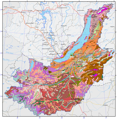
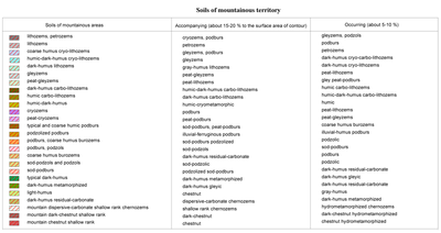
Pic. 2.2.3 Soils of Lake Baikal basin [1]
(Legend to the pic. 2.2.3)

The area showing the simultaneous features of continuous and intermittent permafrost, embrace more than 90% of land resources. The geocryological feature of the territory is the correlation between permafrost and the lowering of relief. Soils in the bottoms of valleys and depressions have a lower temperature and the permafrost has the greatest thickness. Permafrost meadow-chernozem soils occupy flat or slightly sloping valleys on deluvium clay and sandy areas and ancient lake sands. Permafrost-taiga soils and ash gray soil are shaped at the elevation from 1000 to 1300 m. The most fertile are permafrost meadow-chernozem soils which yield the highest amount of harvest. These soils are characterized with a high concentration of humus and nitrogen as well as average concentration of sodium. Out of permafrost soils, the least productivity is observed on permafrost grey forest soils. Of intermediary importance are permafrost meadow soils.
The permafrost is related with other cryosolic processes and phenomena such as frost mold, thermokarst, soilfluction, polygon form of relief and ice [3,4]. Frost molds are associated mainly with the powerful layer of loose sediment. Seasonal frost molds are shaped in January and February on the sites of permanent springs, while their height can be 3 m and their diameter - 20-50 m. Thermokarst processes are well developed on the west shore of Lake Baikal, in the Barguzin river valley and at some portions of trough valleys. Thermokarst manifests itself through the formation of thermokarst lakes, swampy lowlands and funnels. The size of thermokarst depressions varies from 10-20 to 150-200 m. The high-mountain belt has well-developed forms of soilfluction: overmoistened melted soil float up from the places free of vegetation. Not infrequently soilfluction covers entire blocks of mountain rocks, sometimes with big trees. In the medium mountains area this phenomenon is slightly manifested and is observed mainly on the northern slopes.
The area of mountain taiga incorporates soils with eluvium-illuvium and non-differentiated profiles (pic. 2.2.4). Baikal range and Severobaikalsky uplands are dominated by ashen-grey and podzolized brown soils with the admixture of peat-brown soils. They are characterized with small thickness of profile, which in the layers of ashen-grey soil can be 30 cm, and in the mountains of Baikal region is about 40 cm. The thickness of brown soils, which can be seen as being at the incipient stage of soil-formation, is even smaller.
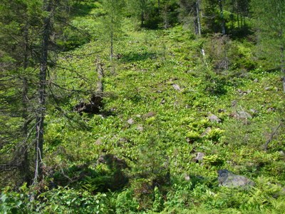
Pic. 2.2.4 The mountain taiga
The soils of piedmont dry grasslands of Baikal region are widespread on Olkhon Island, the adjacent area and in the southern part of the basin (pic. 2.2.5). The formation of dry steppe landscapes with chestnut soils is related with arid mountain zonality. Lack of precipitation is exacerbated by high water permeability of loamy soils. Low bio-productivity is a consequence of the extreme natural-climatic conditions. Agroecosystems are in the state of crisis here while the vegetation cover degrades.
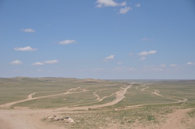
Pic. 2.2.5 The dry grasslands
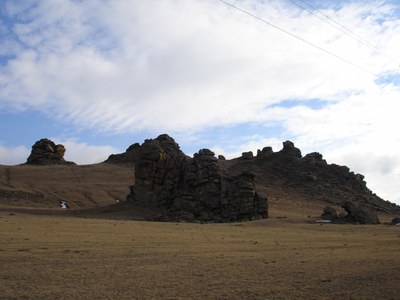
The high-mountain part of the Khamar-Daban, Muysky, Verkhneangarsky and Barguzinsky ranges the main types of soil are petrozems, peat-lithozem. Hard-humus, humic and humic-dark humus soils are formed underneath sub-Alpine meadows. Brown gley soils are formed on the northern slopes in relatively lowered parts of relief and the sections composed of soil-forming elements of heavier granulometric composition.
Kryozems (hard humus), peat-kryozems are well-developed in the zone of bald mountains, being located in a comparatively narrow strip close to the upper margin of the forest. Soils of taiga area have frequently zones of permafrost as well as seasonal permafrost, kryoturbation phenomena and soilfluction.
The structure of soil cover in mountain-taiga zone is heterogeneous and is related with vertical zonality, slope exposition and permafrost. The major types of soils are brown soils, ashen-grey soil, sod-ashen-grey soil, sod-brown soils, grey humus, humic and other soils. The upper part of taiga belt is dominated by kryozems and brown soils, followed by peat –lithozems. Mountain taiga has steppe “islands” with the soils of black humus earth. They can be found on the abrupt slopes of southern exposition, facing wide sections of intermountain depressions.
The steppe zone is dominated by grey metamorphic soils, formed on the foothill parts of depressions and northern slopes of hills inside intermountain depressions or lower parts of deforested slopes, facing steppe depressions. Most of the territory is occupied by these soils in the southern part of Selenginsky uplands. The forest and steppe belt of light coniferous and grass facies can have dark humus metamorphosed soils found mainly on the southern slopes of hills. Grey humus soils were formed on carbonate rocks under the vegetation cover. This combination of soils, inherent to different ecological conditions is the main property of the soil cover at the juncture of taiga and steppe.
In the steppe landscapes of Lake Baikal basin soil cover is represented mainly by black humus soil. It is formed under the meadow steppes. The main portions of these soils are located in Tugnui-Sukharinskaya depression – on Tugnuisky range and southern slopes of Zagansky range, northern slopes of Kudarinskya mountain chain, Minor Khamar-Daba, Monostoiskiy, and Borgoisky ranges. In the north, black humus soil is formed in disparate spots on the north-western slopes of Unegetei range and the Uda and Itantsa river valleys.
The soil cover of dry steppe area is dominated by chestnut soils. They take up a vast territory of Udinsky, Priselenginsky and Borgoiskaya steppe, wide and flat terraces widespread on the southern slopes of hills. The watershed of high ridges can have lithozem soils. On the aeolian deposits of sand of the dry steppe zone, particularly in the areas between the Selenga and Chikoi rivers and Chikoi and Khilok rivers, humus psammozem soils are formed.
Soils of river valleys in the basin are represented mainly by alluvial humus-gley soils, peat-gley soils, dark humus, grey humus and dark humus quasi-gley soils. Within the structure of the soil cover of the upper and middle reaches of the rivers, alluvial layered soil can be found. In steppe and particularly in the dry steppe zone of Baikal region, saline soils and sodium soils are formed in river beds. They are found mainly in the lake depression and lower parts of flat slopes, adjacent to the flood plains where the zone of accumulation of water flow enriched with dissolved salts or the emission of mineralized ground waters to the surface. The most widespread types of salification include sulphate-sodium, sodium-sulphate, sulphate and chloride-sulphate.
Vast areas of saline soils are widespread in Borgoiskaya steppe and lake depressions of Verkhnee and Nizhnee Beloe lakes. Their role is rather significant in Ivolginskaya depression. Also saline forms of relief are observed in the lake depressions of Bichursky district and Tugnui steppe. The Selenga river delta, the Barguzin and some other large portions of land are taken by swamps where peat eutrophic and peat eutrophic gley soils are shaped.
Soils of swampy meadows and lake-wetland complexes are formed in fluvial plains on elevated places, in deltas and the progression cones of temporary water flows (pic. 2.2.6). Alluvial gley soils are formed under the conditions of additional humidity. The elevated parts of mountain rivers on the sand and pebble deposits have alluvial grey humus and layered soils. Alluvial peat-gley (peat mineral) soils are shaped in relatively low locations of river bed under the conditions of lengthy surface and ground moistening as well as on the fringes of the water bodies overgrowing with wetland vegetation. Humus-hydrometamorphic soils are shaped in the central plain of rivers. The lake part of the depression havs predominantly hydrometamorphic permafrost soils.
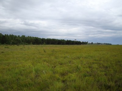
Pic. 2.2.6 Swampy meadow in the Selenga River delta
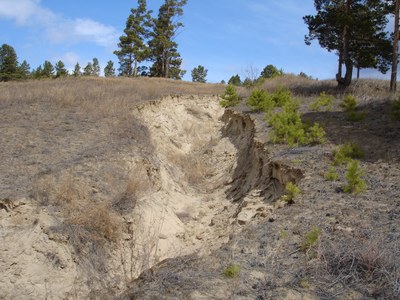
Soils of the basin are subject to destructive processes: wash-away, erosion and deflation (pic. 2.2.7) [3,4]. As a consequence of these processes the loss in harvest production is annually 15-20 %. Agrohydrological properties of soils are determined largely by their mechanical composition. The greatest amount of productive dampness is characterized by sandy soils (90-105 mm). Following an increase in the concentration of smaller fractions, the amount of productive dampness rises reaching 160-190 mm for light loamy soils and 215 mm for heavy loamy soils. The coefficient of water-yielding capacity is around 65-75%.
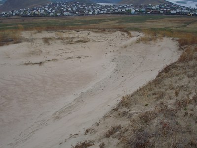
Pic. 2.2.7 The deflation
According to observation data, in spring the reserves of productive dampness in the meter-deep layer of soil is on the average 80 mm, for sandy soils and for loamy soils it is 100 and 160 mm, respectively. In summer, in July and August, they shrink for sandy soils up to 60 mm and for loamy soils up to 100 mm. Due to the low concentration of productive dampness in the soils of light mechanical composition and their insufficient moistening in the vegetation period, the acquisition of stable harvests is only possible through irrigation. Of great significance are agrotechnical devices aimed at preserving dampness in soil and the protection of soil from water and wind erosion (pic. 2.2.8).
Pic. 2.2.8 The water erosion
The reduced anthropogenic impact on ecosystems of the Lake Baikal basin during the last decade contributes to the restoration of natural landscapes and the lowered rate of aridification. Therefore, desertification is not observed within the Russian part of the basin, in contrast to Mongolia [23].
Scientists have identified 34 types of soils in Mongolia. The most common type of soil - brown soil - comprises 40.4% of the total territory, of which 22.6% is located in mountainous areas and 17.8% is in plain areas (pic. 2.3.2). The brown soil is further classified into three sub-types, including dark brown, genuine brown and light brown soil. The most widespread is dark brown soil (17.6%), followed by genuine brown soil (11.9%), and light brown soil (10.9%) [15].
The Law on Soil Protection and Prevention of Desertification introduced a classification of the extent of soil degradation and desertification, categorizing it as «weak», «medium» and «strong» [16]. «Weak» extent of soil degradation implies that less than 5% of the soil is polluted or eroded; «medium» extent of degradation implies that 5-20% of soil is polluted or eroded; and «strong» extent of degradation implies 20-50% of soil is polluted or eroded.
In Mongolia, precipitation increases from the central part to the north following the changing relief and climate, and steppe landscape is replaced by meadow-steppes, meadows, swamps, forests and taiga-forests. In the mountainous region in the north of the country, the soil moisture is relatively higher due to more precipitation as well as humidification by big and small rivers and multi-year permafrost.
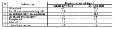
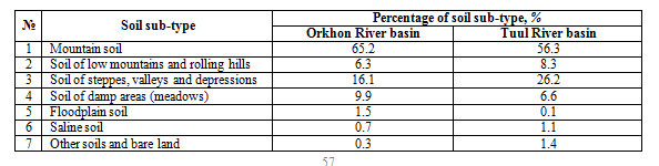
In the wide valley between the Khangai and Khentii mountain ranges, arid plain soil and desert-plain soil are spanning till the Tagna mountain range. Arid-steppe brown soil covers a significant area of the valleys located in Orkhon-Selenge basin. The Orkhon and Tuul river basins have mountain dernotaiga soils, low mountain chestnut soils, steppe valley brown and dark brown soils, while meadow and river valley soils are dominant (table 2.2.1).
Table 2.2.1 Percentage of soil sub-types in the Orkhon and Tuul river basins
The extent of land degradation can be defined as «weak» for 35.3% of lands, «medium» and «strong» for 25.9% and 6.7% of lands, respectively (pic. 2.2.9) [17].
Pic. 2.2.9 The soil degradation
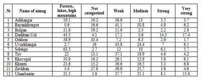
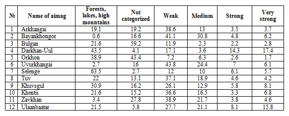
The desertification maps created by Geoecological Institute of Mongolian Science Academy in 2006 and 2010 were compared, and it was revealed that distribution of the areas with «strong» desertification changed during the period, i.e. numerous new desertification hotspots have formed [15]. For instance, new desertification hotspots were observed in the north of Bayankhongor aimag and Orkhon river basin. However, along the border of Uvurkhangai and Dundgobi aimags the area of lands affected by desertification have reduced (Table 2.2.2).
Table 2.2.2 Extent of desertification in the aimags within the Selenga River basin (%)
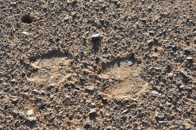
Increased logging, forest fires, vegetation damage by pests, mining (mineral extraction) and unauthorized tree-cuttings cause imbalance in forest ecosystems and facilitate desertification processes. The Law on Soil Conservation and Prevention of Desertification approved by State Great Khural in 2012 established incentive measures for individuals and organizations conducting soil conservation and desertification prevention activities (pic. 2.2.10).
Pic. 2.2.10 The hotbed of desertification
