3.4 Forest resources
3.4 Forest resources
The major bulk of forests in Lake Baikal basin is to be found in the Russian part of the water catchment area, where 38 forestry services are operating (pic. 3.4.1) [3,4]
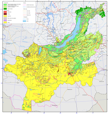
Pic. 3.4.1 Forest resources and their use in Baikal basin [1]
Forests are mainly represented by two groups of trees - coniferous and deciduous trees. Among the coniferous forests, pine (Pinussilvestris) and larch (Larix) are represented equally – and account for 25% of forests (pic. 3.4.2). Cedar forests are widely represented (Pinussibirica) - 17%.
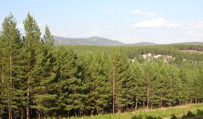
Pic. 3.4.2 The coniferous forest
Among the deciduous forests, birch (Betula) prevails - 17% (pic. 3.4.3). Shrubs in the high-mountain zone are formed by dwarf cedars, and in the river valleys – by dwarf birch thickets as well as willow shrubs. Forests areas are covered mainly by coniferous trees (more than 70%). They include larch, pine, cedar, birch and aspen.
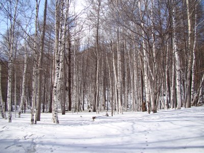
Pic. 3.4.3 The birch forest
Irkutsk region. The area of land, covered with forest vegetation (forest lands – forest fund, specially protected natural territories) within the confines of BNT (does not overlap with Lake Baikal basin) is 8,626 thousand ha (in 2011 – 8 ,623.0 thousand ha), of which 95% is covered by forests and 5 % by shrubs [3,4].
The rated wood cutting of mature forests within BNT in 2013 was 8597.2 thousand m3 (in 2012 – 8,893.2 thousand m3). During 2013, about 2,304.3 thousand m3 of forest was cut down (in 2012 – 2,133.2 thousand m3), which equals to 24 % of the rated wood-cutting. The area of wood cutting was 1.9 thousand ha (in 2012 – 1.8 thousand ha). Sanitary cutting was undertaken on the area of 4.5 thousand ha (in 2012 – 4.8 thousand ha).
Forest restoration within BNT was undertaken in 2013 on the area of 11.9 thousand ha (in 2012 - 7.9 thousand ha), including forest planting over the area of 1.3 thousand ha (in 2012 – 1.2 thousand ha). Young trees were transferred onto 14.7 thousand ha (in 2012 – 14.2 thousand ha) of forest fund area covered with forest vegetation.
Forests in this part of the basin are subject to fires because of the frequent draughts and strong winds. In 2013, the part of Irkutsk region within BNT had 327 registered forest fires (in 2012 – 201 fires), 5.4 thousand ha (in 2012 – 1.5 thousand ha) of land were affected by forest fires. As a way to speed up detecting and extinguishing forest fires, forest lands of the total area of 9,562.1 thousand ha were divided into the zones of fire hazard monitoring – a zone of terrestrial monitoring (717.6 thousand ha), a zone of aircraft monitoring (8,125 thousand ha), and a zone of the 2nd level space monitoring (719.5 thousand ha). The fire prevention activities were undertaken, including construction and maintenance of roads – 1,050.3 km (839.9 km in 2012); setting up and maintenance of fire-protection barriers – 2,041.5 km (1,787.5 km in 2012); conducting controlled burning – 21,878 ha (11,485 ha in 2012).
In 2013, the employees of forest services located within BNT organized 1,959 raids (2035 in 2012) to forestall illegal wood cutting and illegal trade in wood in the region, 520 of the raids were conducted jointly with police. The damage to the forest fund of Irkutsk region was estimated at 217 million rubles. Damages amounting to 9.7 million rubles were awarded by court rulings. The use of forests by the renters of forest sites is undertaken strictly in accordance with the projects of forest management based on the state environmental expertise. The renters of forest sites, who failed to elaborate their forest management project by the established procedure, are not allowed to work.
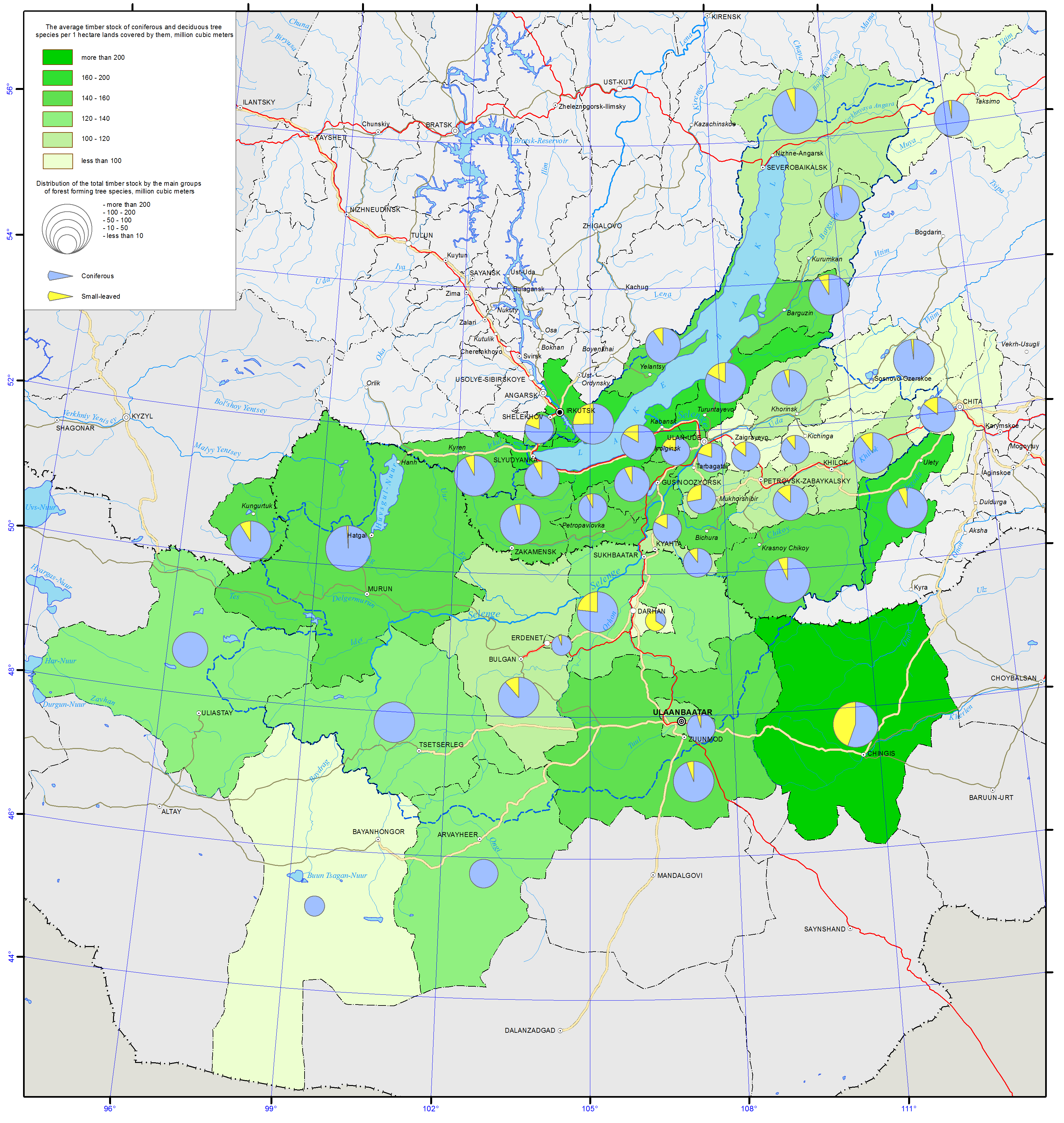
Republic of Buryatia. The area of land, covered with forest vegetation (forest lands – forest fund, specially protected natural territories) within the confines of BNT in 2012 equals to 11,891.7 thousand ha. The species of trees covering the area are represented by coniferous trees (75.4%), soft-wood trees (8.8%), hard-wood trees (0.001%) and shrubs (15.8 %) (pic. 3.4.4) [3,4].
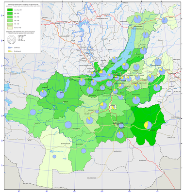
Pic. 3.4.4 Timber stock of the main groups of forest forming tree species [1]
The biggest forest areas are in Zakamensky (forest density – 86.6%), Khorinsky (81.5%), Pribaikalsky (80.8%), Zaigraevsky (74.1%) and Kizhinginsky (70.2%) districts of Buryatia. The least number of forests is in Kabansky (32.1%), Kyachtinsky (32.1%) and Mukhorshibisrky districts (41.8%) [2].
Forest management in the republic is conducted in accordance with the Forest plan of the Republic of Buryatia, approved by the resolution of the BR Government and by the regulations of the forest services. As a way to implement the resolution of the RB Government on “The investment projects in the field of forest management”, the Forest plan of the Republic of Buryatia has been equipped with sections concerning the implementation of investment projects.
The rated wood cutting area of mature forests decreased by 1% compared to 2012 and amounted to 4,794.3 (4,841.4 thouand m3 in 2012). During 2013, 891.9 thousand m3 of wood were cut (930.3 thousand m3 in 2012), which is 19% of the rated wood cutting. In 2013, cutting of mature forests dropped by 4 % compared to 2011. Maintenance cutting in 2013 dropped by 29% compared to 2012 and equaled to 23,1 thousand ha. Sanitary cutting was conducted on the area of 7.0 thousand ha (8.4 ha in 2012).
In 2013, forest restoration was conducted on the area of 11.6 thousand ha (20 thousand ha in 2012), trees were planted over 2.1 thousand ha of the area (2.1 thousand ha were used for the purpose in 2012). The area of young forests transferred to the category of lands covered with forest vegetation was 18.9 thousand ha in 2013 (24.8 thousand ha in 2012) (pic. 3.4.5).
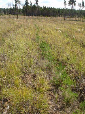
Pic. 3.4.5 Forest restoration (Tarbagataisky district)
In 2013, the territory covered by forest services had 474 registered forest fires (641 in 2012). Compared to 2012, the number of fires decreased by 26%. The forest land area affected by fires was 20.5 thousand ha, which was 83% less than in 2012 (117.73 thousand ha) (pic. 3.4.6).
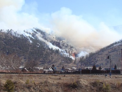
Pic. 3.4.6 Forest fire (Pribaikalskiy district)
As a way to speed up detecting and extinguishing forest fires, forest lands of the total area of 13,146 thousand ha were divided into the zones of fire hazard monitoring – a zone of terrestrial monitoring (2,388 thousand ha), a zone of aircraft monitoring (7,455 thousand ha), and a zone of the 1st level space monitoring (3,303 thousand ha). The fire-prevention activities were held, including controlled burning (260 thousand ha), setting up of mineralized strips (2488.67 km), and maintenance of mineralized strips (4,339.72 km) (pic. 3.4.7).
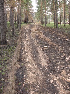
Pic. 3.4.7 Mineralized strip for fire protection (Ivolginsky District)
The Agency for Forest Resources of the Republic of Buryatia has concluded inter-departmental Agreements on cooperation in combating forest fires with the State Forest Service of Irkutsk region, the chief branch of the Ministry of the Russian Federation for Civil Defense, Emergencies and Elimination of Consequences of Natural Disasters in the Republic of Buryatia, central base of the aviation forest air protection.
In 2012, the Federal budget allocated 73.9 million rubles of subsidies, while the Republic budget allocated 3.9 million rubles for purchasing fire-control equipment. At the same time, 37 units of fire-control equipment were put into operation.
As a way to enhance the efficiency of forest reproduction activities, the decision was made on the construction of a forest seed-selection center. The project was developed, for implementation of which the amount of 6.5 million rubles was allocated.
With the purpose of using the uncultivated forest resources, three investment zones (Northern, Eastern and Southern) with a total area of 2.8 million ha were identified. The total annual timber production within the three zones is 1.09 million m3, including 1.04 million m3 of coniferous trees. The forest zones for geological exploration and mining (1,225 ha), for recreational purposes (213 ha) and other purpose areas were identified.
During 2012, 3 auctions selling the right for concluding forest site lease treaties were conducted, including land leases for recreational and agricultural activities, producing food from forest resources, etc. On the basis of the auctions, 22 forest sites of a total area of 9,462.2 ha were leased out [13].
In 2012, the lease holders procured 825.6 thousand m3 of wood, which was 39% of the allowed 2,107.3 thousand m3. Only those lease holders, who provided their forest-management projects, received positive assessment by the state expertise and submitted forest declarations, were allowed to procure wood [3].
In 2013, the Government of the Republic of Buryatia approved and enforced guidelines regarding preparation to the fire danger season of 2013 and methods of extinguishing fires. Specialized forest fire departments received licenses for fire extinguishing activity. 157 firefighters were trained to oversee/coordinate fire extinguishing activities.
The level of forest management and successful exploitation of forest resources are to a great extent determined by the presence of transportation infrastructure in forests. The length of roads of all-year operation is 2.1 km per 1000 ha. The Forest plan of the Republic provides for the construction of forest roads with the total length of 840 km till 2017 [6].
Zabaikalsky Krai. The area of land covered with forests within Lake Baikal basin is 4,715.4 thousand ha (in 2011 – 4,715.9 thousand ha). The area of lands covered with forest vegetation increased by 0.1% in 2013.
The rated wood cutting of mature forest plantings within Baikal Natural Territory in 2013 changed slightly compared to 2012 and equaled to 2,483.9 thousand m3 (2,484.0 thousand m3 in 2012). In 2013, 543.0 thousand m3 of timber was produced (628.3 thousand m3 in 2012), which accounts for 21.9 % of rated wood cutting. The volume of maintenance cutting dropped by 16% compared to 2012 and amounted to 0.6 thousand ha. Sanitary cuttings were undertaken on the area of 2.5 thousand ha (3.4 thousand ha in 2012).
Forest restoration was carried out in 2013 on the area of 5.8 thousand ha (9.2 thousand ha in 2012). Trees were planted on the area of 0.9 thousand ha (1.1 thousand ha in 2012). Young saplings were transferred onto the area of 15 thousand ha (13.4 thousand ha in 2012) that belongs to the category of lands covered with forest vegetation.
In 2013, the territory of Zabaikalsky Krai had 187 registered fires. Compared to 2012, the number of forest fires decreased by 25% (249 fires in 2012). The area affected by forest fires reduced 6.8 times and amounted to 7.3 thousand ha.
Zabaikalsky Krai is implementing the long-term goal-oriented program “Forest protection from fires (2011-2014)” [3,4]. The program has funded the production and installation of visual aids (posters, panel pictures), shooting of video clips dedicated to the theme of fire combating, and holding the activities on state contracts. The state contract activities were the following: the instruction courses for two aircraft observers and forest fire managers (103 persons) were held, the project of forest-fire zoning was designed; 4 specialized forest-fire equipment (semitrailers) were purchased; the first stage of the forest-fire equipment project was designed; the clearing of waste along the roads was undertaken.
The Government of Zabaikalsky Krai approved the long-term goal-oriented program «Forest restoration in Zabaikalsky Krai (2012-2015)». The main activities of the program include: procurement of seeds, fitting out the nursery with the new equipment and increasing the amount of planting material. In 2012-2013, 624 kg of coniferous tree seeds were prepared. All the seeds were checked for sowing quality and were of the 1st class of quality. In 2012-2013, 3,096.5 thousand seedlings of the main forest comprising tree species were grown.
The Government of Mongolia has formulated its National Forest Policy and Master Plan of Forest Management (pic. 3.4.8) [9].
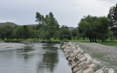
Pic. 3.4.8 Forest area on the river Tuul, a suburb of Ulaanbaatar
The use of saxaul for fuel is banned in areas with saxaul forests. Nationally, a total of 37,211.5 thousand ha of land was forested and reforested between 2008 and 2011, and windbreaks were established on 1,000 ha (Table). Within the framework of Green Belt Programme, windbreaks were established on 367 ha in 2005, 461 ha in 2006, 300 ha in 2007, 426 ha in 2008, 271.4 ha in 2009, 253 ha in 2010 and 365 ha in 2011. The afforestation and reforestation measures generated permanent and temporary jobs for 6,798 people in 2011.
In order to ensure the quality of forestation and reforestation efforts, the guidelines on “Purchasing and Accounting of Afforested Areas” have been issued. In accordance with the regulation, 194.3 ha of afforested land, managed by citizens for more than three years, were purchased by the State and registered in the national forest fund (56 ha in 2008, 77 ha in 2009 and 61.3 ha in 2010). Hentii aimag has generated good practices in implementation of the regulation that can be replicated to other aimags.
Ministry of Environment and Green Development defined the maximum limits for timber harvest as 1,128,464 m3 and 1,058,239 m3 for 2013 and 2014, respectively. For the Selenga river basin area, the maximum limits were 627,542 m3 and 601,167 m3 for 2013 and 2014, respectively. Maintenance cuttings were conducted over 13,900 ha and 13,180 ha in 2011 and 2012, respectively.
Despite the above achievements, the risks of forest degradation persist and the extent of forest depletion and degradation is still at an alarming rate urging immediate attention. Latest statistics indicate that approximately 1,395,661 ha of forest were affected by fire and 950,000 ha were damaged by insects [15].
