4.4 Dangerous natural phenomena and processes
4.4 Dangerous natural phenomena and processes
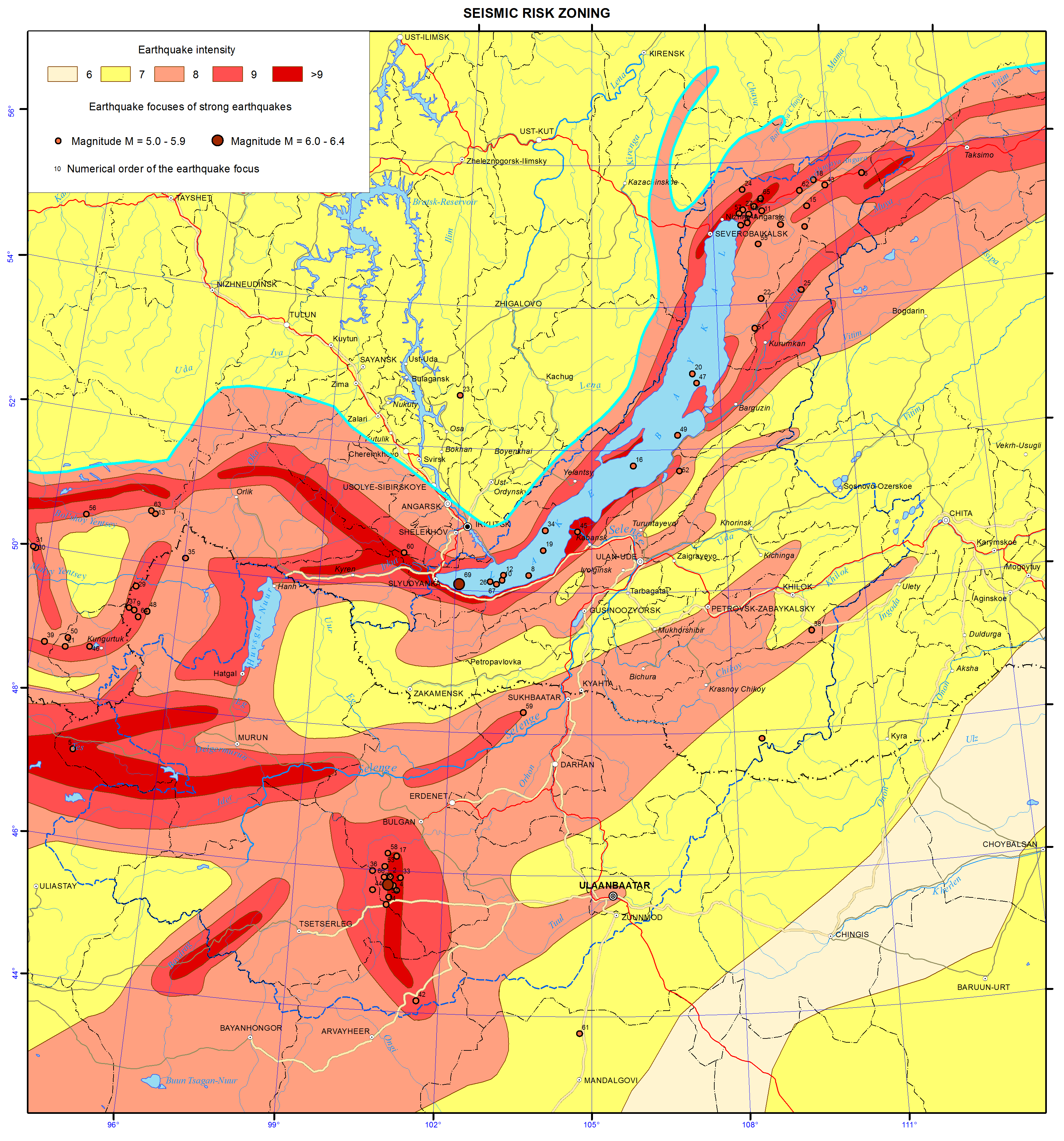
Earthquakes. Lake Baikal basin belongs to the seismically active Mongolian-Baikal seismic belt. The area is characterized by «very frequent» earthquakes of magnitude 2-3, «moderately rare» earthquakes of magnitude 6-7 and «rare» earthquakes of magnitude 9-10 [10]. Based on seismic zoning, the basin area is part of the Baikal rift zone and Transbaikal zone (pic. 4.4.1). The former is characterized by the maximum seismic activity of magnitude 9-10, while the latter by moderate seismic activity and «transits» from Baikal and northern Mongolia of magnitude up to 8. In addition, statistics show that even moderate earthquakes activate exogenous processes, and are often accompanied by landslides, rockslides, glacier movements and lead to the formation of mudflows, avalanches, etc.
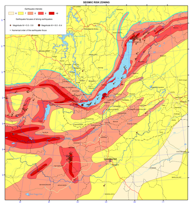
Pic. 4.4.1 Seismic risk zoning of Baikal basin [3]
Most of the earthquake epicenters are located in Lake Baikal and the Selenga River delta. Catastrophic consequences of earthquakes of magnitude 9-10 that took place in the area are well documented in archives and chronicles. Tremors of magnitude 6-7 were recorded in southern Buryatia as a result of two strong earthquakes of magnitude 11 and 12 that took place in Mongolia on July 7th and 23rd in 1905, respectively. They were felt even in the village f Kabansk. In a village of Kultuk, 500 km away from the epicenter, two railroad tunnels were damaged due to displacement of rock masses. A number of other earthquake can be mentioned: 1) the ridge Dzhidinskiy in Northern Mongolia (06/02/1957), magnitude 9; 2) Mogot on the river Orkhon in Northern Mongolia (1/5/1967), magnitude 10; 3) Northern Mongolia, near Zakamensk (17.01.1984), magnitude 7-8; 4) Orongoy, Buryatia (02.10.1980), magnitude 7; 5) the interfluve of the rivers Selenga and Zheltura (05.13.89), magnitude 7.
Tsagan earthquake (01/12/1862) is particularly noteworthy. Due to the earthquake, a portion of steppe between Harauz channel and the Enkhaluk river - a tectonic block with a surface area of 260 km2 - dropped to a depth of 7-8 m. 203 km2 of the land was inundated by the lake, forming Proval Bay. The earthquake was of magnitude 10. Tremors of magnitude 8 were felt at distances of 170-180 km from the epicenter. The earthquake was felt on the area of 2 million km2, large rock slides were recoded within 400 km 2 around the epicenter.
The intensity of earthquakes with epicenters in Lake Baikal and Mongolia can reach magnitude 6-7 and even 8, while the frequency of such earthquakes is 0.028-0.049. Earthquakes with epicenters in Mongolia and within the zone of Dzhida-Vitim fault pose greater threat to settlements in Zakamenskiy, Dzhidinskiy and Kyahtinskiy districts of the Republic of Buryatia. Earthquakes with epicenters in Lake Baikal endanger population of Kabanskiy, Pribaikalskiy, Ivolginskiy, Tarbagatayskiy and Zaigraevskiy districts and Ulan-Ude city.
More than 40 earthquakes of magnitude 6 or more took place in Mongolia during the last two decades. Most of the earthquakes occur in the areas of the mountain ranges Altai, Khangai, Khovsgol and Bulnai. There were 4 earthquakes of magnitude above 8 during the 20th century – in Zavkhan aimag (1905), Arkhangai aimag, in the Mongolian Altai mountains (1931) and Gobi-Altai (1957).
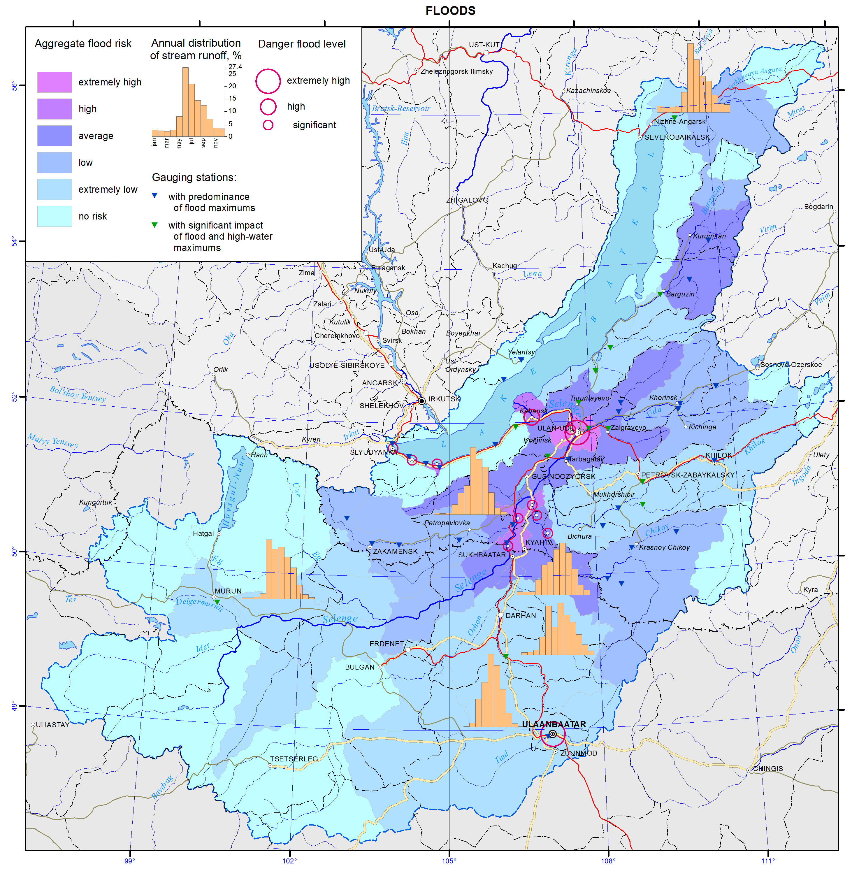
Floods. Archival, literary and historical documents provide evidence of frequent catastrophic floods within the basin [10]. According to available statistical data on water levels in the Selenga river during 1936-2012, a number of major floods (above 400 cm) took place on the following dates: 06/11/1936; 08/05/1940; 08/05/1971; and 29/07/1973. Besides, a series of smaller floods (above 300 cm) took place in 1938, 1942 and 1990s. The driving factors of floods are frequent cyclones during the second half of summer bringing heavy rainfall, as well as large masses of snow accumulated in mountains during the preceding winter, and the local landscape characterized by mountains and hollows (pic. 4.4.2).
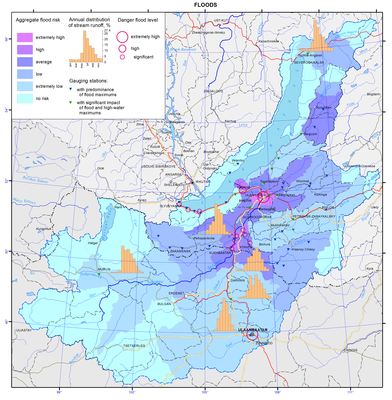
Pic. 4.4.2 Floods of Baikal basin [3]
Within the basin, 61–90% of floods are flash floods caused by rainfalls or snow meltwater, while only 10% are riverine floods. The Uda river is an exception with 31% of floods being riverine due to water input from the mountainous rivers Kurba and Ona flowing into it.
Flash floods can cause serious damage as, in some areas, the water level may rise by more than 400 cm. The basin’s mountainous relief and well branched river networks facilitate rapid collection and rise of water in rivers. During the largest flooding event in 70 years on the Dzhida river (1971), water level rose by 4.57 m/day (Khamnei monitoring station) and 2.79 m/day (Dzhida monitoring station). During a flood on the Chikoy river (1973), water level rose by 1.88 m/day (Povorot monitoring station) and 1.19 m/day (Cheremhovo monitoring station). Similarly, water level rose by 1.1 m/day during a flood on the Uda river (1991). The decline is slower, averaging 0.3-0.5 m/day. Rapid rise of water levels in mountainous tributaries (the rivers Khamnei, Kurba, Ona, etc.) is also associated with their location in permafrost zones, where soil infiltration is significantly reduced.
Duration of floods typically ranges between 10-15 days or more on the rivers Dzhida, Chikoy and Khilok, and 20-25 days on the Selenga river, but may reach 38 days (Ulan-Ude, 1936).
Forest fires. Typically arid conditions during spring-summer period and prevalence of pine, which has higher flammability than other trees, create fire-prone environments. Majority of forest fires have human causes [10].
Over the last decade, 431-1224 fire incidents were registered each year. The fires affected 6617 to 100 000 hectares and caused huge losses. Besides, the negative consequences of forest fires include smoke emissions and associated human health risks, altered water balance and disturbed natural habitats of wildlife. The forest fires occurring near settlements pose the greatest threat. According to statistical data, up to 140 fires break out every year around the city of Ulan-Ude, putting at risk its inhabitants (pic. 4.4.3).
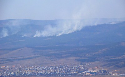
Pic. 4.4.3 Forest fires in the suburbs of Ulan-Ude city.
Till now the situation remains quite grave. For example, 1533 fires over the total area of 89630 hectares were registered in 2011, which was 731 incidents more than in 2010. The area affected by fires in 2011 also increased by 53 708.99 hectares compared with 2010. Significant numbers of fire break-outs were reported in the following districts: Pribaikalskiy – 148 fires over 16 408.54 ha; Zakamenskiy – 68 fires over 11 671.4 ha; Kizhinginskiy – 101 fires over 7356.75 ha; Zaigraevskiy – 208 fires over 4750.35 ha; Tarbagataiskiy – 131 fires over 7175.20 ha; Khorinskiy – 120 fires over 7557.82 ha; Ulan-Ude city – 134 fires over 406.78 hectares (MES RB). According to experts, the main reasons of fire break-outs were 1) burning initiated for agricultural purposes but left uncontrolled or gone out of control (52.8% of all fires); 2) other human causes – arson, accidents, etc. (45.7%); and 3) natural causes - dry thunderstorms, spontaneous ignition (0.8%).
Mudflows. Tectonic activity of the Baikal rift, deep faults that cause fracture and fragmentation of rocks, and weathering processes lead to accumulation of debris on mountain slopes, that gradually drifts down the slopes [10].
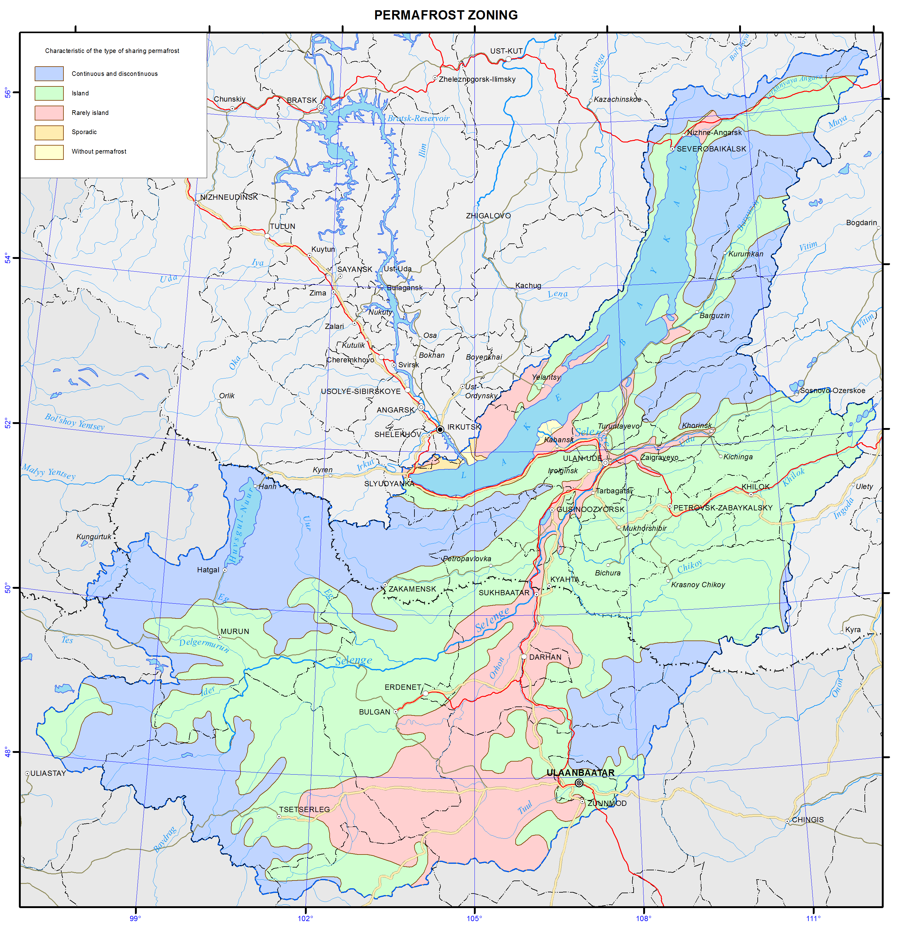
During prolonged rainfall (0.1-0.2 mm/min), short-term heavy showers (1.5-2.0 mm/min), and in the presence of permafrost (pic. 4.4.4), the rainwater flows down mountain slopes carrying along surface soil and debris. The mixture enters mountain rivers further gaining speed and mass. Mudflows incorporate and carry along large amounts of mud, rock debris, water, plant material, etc. The rivers and temporary river beds in the mountain ridges Hangarulskiy, Dzhidinskiy, Hamar-Daban and Ulan-Burgasy are prone to mudflow formation. Numerous mudflows were recorded for upper and middle reaches of the Dzhida river and the mountainous rivers Modonkul, Khamney, Zun-Naryn, Tsakirka, Ulyatuy, Borgoy and others.

Pic. 4.4.4 Permafrost zoning of Baikal basin [3]
In the Southern Baikal region (the slopes of Hamar-Daban ridge), mudflows of varied intensities were recorded in 1863, 1889, 1903, 1910, 1915, 1921, 1927, 1932, 1934, 1938, 1952, 1960, 1962, 1965 and 1971. Mudflows were observed for small rivers in the Selenga midlands, for example the rivers Kuytunka and Tarbagatay in 1914, 1950 and 1961. Strong mudflows that caused significant damage took place along the rivers Borgoy (in 1965) and Gryaznukha (in 1968). In addition, there is evidence of mudflows in different parts of the basin in 1960-1962.
Thus, the small rivers of the basin – Kuytunka, Tarbagatayka, Sukhara, Savva and Kyahtinka – are prone to mudflow formation. Mountain slopes formed by loose sand and sandy loams and areas with gully erosion in Tarbagatajsky, Mukhorshibir, Bichursk and Kyakhtinsky districts are especially vulnerable with respect to mudflow formation. The probability of a mudflow formation in the areas is equal to 0.08-0.2.
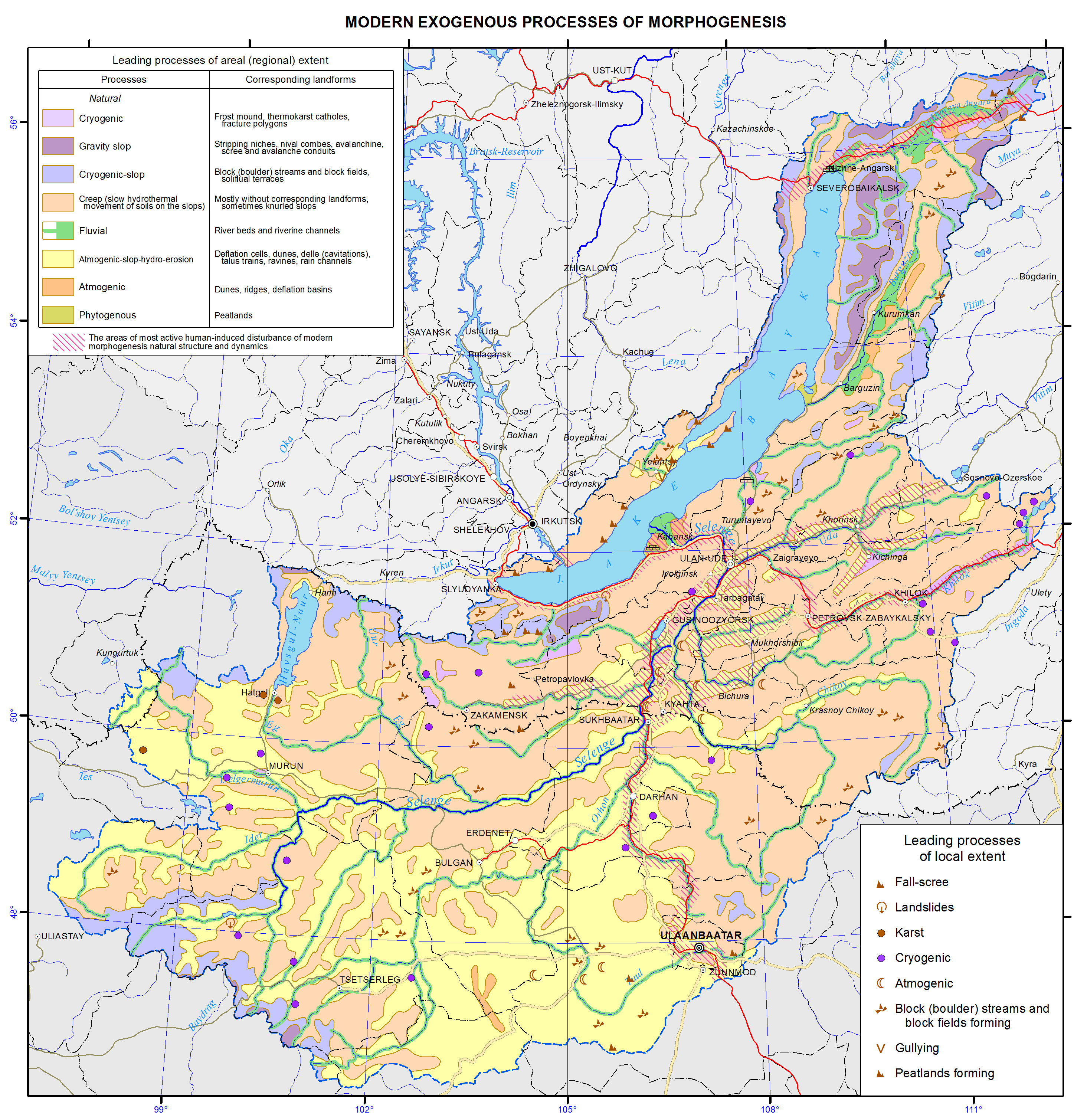
Erosion-accumulative processes. With the development of gully and river erosion, the erosion products are washed off into rivers, form sediments and contribute to silting and shallowing of small and medium-size rivers, that, in turn, contributes to the development of channel deformations [10]. Natural conditions within the basin, contribute to the high predisposition to the development of erosion processes (gully erosion and deflation). At the same time, intensive land use has led to the widespread erosion of hollows and slopes. Eolian processes are the processes of relief formation due to wind. During strong winds, dust storms take place that facilitate redeposition/redistribution of soil and changes in the microrelief. The processes actively proceed in areas with loose sand and disturbed soil and vegetation layer. The processes are widespread on the northern slopes of the mountain ridges Zaganskiy, Hudunskiy and Tsagaan-Daban, as well as in the interfluve area of the rivers Selenga and Chikoy. In some parts of the areas, zones of exposed moving sand are observed. The average index of deflation is equal to 0.01-0.5 (pic. 4.4.5).
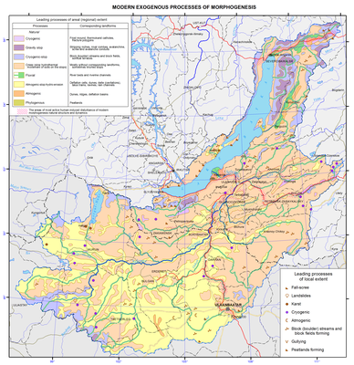
Pic. 4.4.5 Modern exogenous processes of morphogenesis of Baikal basin [3]
Erosion processes are ubiquitous in the basin and are observed in valleys of the rivers Selenga, Uda, Dzhida, Khilok and Chicoy. Active development of the processes is noticed in the steppe areas of the ridges Tsagaan-Daban, Malhanskiy, Zaganskiy and in the areas cleared of the forest. The density of gully erosion networks reaches 12 km/km2 in some areas. Currently, there are 1.2 thousand gullies in the basin that are longer than 400 m. The total length of all the gullies is equal to 1.9 thousand km. The total area of erosion-affected land is in the range of 1-13 / 100 km / km 2 , on average it is 5/100 km / km 2 , and the density of gully networks is 0,03-0,19 km / km 2 (0.08 km / km 2 ). In areas with thick layers of loess deposits, gullies reach a length of 5-7 km and a depth of 40 m. Borgoy, Gusinoozersk, Tugnui and Uda valleys are affected by erosion to a lesser extent (0.3-1 km/km2). On the slopes of the ridges Malhanskiy, Zaganskiy, Kudunskiy, and Kurbinskiy, linear erosion occurs in the areas cleared of the forest. The growth rate of gullies and ravines reach 0.5-26 m/year.
Within the basin, a high incidence of anthrax cases was recorded. As a result of an outbreak of anthrax in Kyakhtinskiy district (1999), 14 people fell ill and one died. Based on data from government agencies, there were 161 anthrax outbreak zones in Buryatia, among the areas at risk are Kabanskiy, Selenginskiyi, Zaigraevsky and Kyakhtinskiy districts. Diseases such as brucellosis, tuberculosis, leptospirosis, rabies, and foot and mouth disease also pose risks [10].
In Mongolia, the frequency of natural disasters has increased during the last decades. The increased frequency is often linked with and explained by climate change. The following natural disasters occur frequently: earthquakes (pic. 4.4.1), blizzards, heavy snowfalls, dust storms, “zuds” (harsh winters), flush floods (pic. 4.4.2), mud flows (pic. 4.4.5), wildfires, droughts, and desertification processes [2,9].
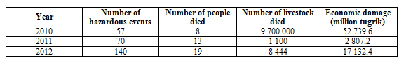
In 2008, natural disasters resulted in 82 human casualties, loss of 414918 heads of livestock, and economic damage of 3.5 billion tugrik. In 2009, there were 47 human casualties, 446402 heads of livestock lost, and 12.4 billion tugrik of economic damage sustained. In 2010 (the year of zud), the country sustained huge damages due to an unusually harsh winter resulting in loss of 9.7 million heads of livestock, 52.7 billion tugrik of damages and 8 human casualties. In 2011, there were 11 human casualties, 1100 heads of livestock lost and 2.8 billion tugrik of economic damage sustained.
Table 4.4.1 Damages caused by natural disasters during2010-2012
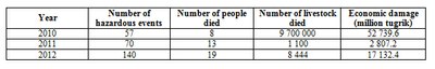
The following natural disasters took place in 2012: storms (13 events), heavy rainfall (2 events), extremely hot weather (2 events) and extremely cold weather (9 events). The conditions all together accounted for 1 human casualty and 6555 heads of livestock lost. Besides, roofs of 36 houses broke, 17 gers crashed and 58 electricity poles fell down.
Dzud is a Mongolian term for a severe winter in which large numbers of livestock die from starvation, cold or lack of water. There are various kinds of zuds, one of which is a white zud - an extremely snowy winter when livestock are unable to graze due to the tick snow cover. Another type of zud is a black zud, which is a cold snowless winter often preceded by draught conditions during summer. During a black zud, livestock dies primarily due to the lack of water, as well as starvation and cold. The most recent zud happened during winter of 2009-2010. 175 soums is 18 aimags were affected, 9.7 million heads of livestock died and the total economic damage sustained was estimated at 526.8 billion tugrik.
Droughts. With the prevailing arid and semi-arid conditions, Mongolia is a drought-prone country [2]. Most of the country’s territory regularly experiences droughts. Drought takes place once in 10 years in the country’s forest steppe and steppe zone, whereas in the desert zone the frequency is once in 2 years.
Bibliography
1. State report “On the state of Lake Baikal and measures for its conservation in 2013” - Irkutsk. Siberian branch of “Rosgeolfond”, 2014. - pp. 462. http://www.mnr.gov.ru/regulatory/list.php?part=1258 (in Russian)
2. State of the Environment in Mongolia, 2011-2012 (www.tsag-agaar.gov.mn/index.php/observation/environment)
3. Ecological atlas of the Lake Baikal basin – Irkutsk: Institute of Geography SB RAS. 2014. http://bic.iwlearn.org/ru/atlas/atlas
4. База данных Всемирной организации здравоохранения http://www.who.int/collaboratingcentres/database/ru/
5. Timoshkin О.А., Malnik V.V., Sakirko M.V., Boedeker K. Ecological crisis on Lake Baikal: Scientists make a diagnosis// Nauka is pervyh ruk. № 5 (59), 2014
6. (http://estandard.mn/filebase/files/4943-2011.pdf)
7. Khamnaeva G.G., Kulikov A.I., Tsydypov B.Z. On the current state of the environment in the town of Zakamensk and adjacent areas // Bulletin of BSAA - 2013. - №3. - p. 79-85.
8. Water Quality of the Kharaa River Basin, Mongolia: Pollution threats and hotspots assessment report, 2013
9. MEGD, «Strengthening Integrated Water Resource Management in Mongolia» project, «Integrated Water Management Assessment Report, Volume I», http://www.tuulgol.mn/dmdocuments/reports/national_report_volume1_english.pdf
10. Borisova T.A. Natural and anthropogenic risks within the Lake Baikal basin. Novosibirsk: "Geo", 2013. - 126 p.
11. State report “On the state of the environment and its proptection in the Republic of Buryataia in 2012”. http://minpriroda-rb.ru/upload/iblock/9cb/frmoytmrq2013.pdf (in Russian)
State report “On the state of the environment and its proptection in the Republic of Buryataia in 2013”. http://minpriroda-rb.ru/upload/iblock/26b/gocdoclad_2013.pdf (in Russian)
