1.4 Climatic conditions
1.4 Climatic conditions
The location of Lake Baikal basin in the central part of the vast Eurasian continent and its mountain-depression relief have equally determined the particular and, in a sense, unique climatic conditions. The specific feature of the climate is its abrupt and frequent spatial variability due to the presence of mountain ranges of different heights and orientation, intermountain depressions and valleys, orographic forms, which produces a strong impact on the local circulation of air masses, changing abruptly the main orographic indicators and producing uneven climate.
The territory is characterized with extremely continental climate with considerable annual and daily fluctuations of air temperature and uneven distribution of precipitation by seasons [3]. The exception is a narrow strip along the lake, where the signs of maritime climate with cooler summer and milder winters as compared to the surrounding territories. Extremely continental climate is characterized with cold winters and hot summers. One of its specialties is that, during the cold period, the region faces a powerful northeastern extension of the Siberian anticyclone, which comes in September-October and disappears in April-May.
Low winter temperatures are easily tolerated due to dry air. Severe windless winter is followed by late windy and dry spring with night frost, lasting till the first decade of June. High summer temperatures can be felt only at noon hours, while the morning and evening hours are enjoyable for their cool temperature. Summer is short, its first half is droughty and second half (July-August) – rainy. Autumn is rather warm and lasts until Baikal is covered with snow.
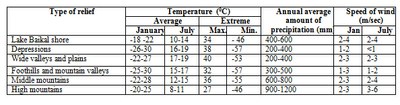
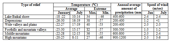
Climatic conditions in Lake Baikal basin are determined by the character of atmospheric circulation and radiation regime as well as by the structure of the surface and the impact of water masses on the shore regions (table 1.4.1).
Table 1.4.1 Distribution of temperatures, precipitation, speed of winds in correlation with relief
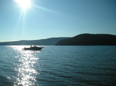
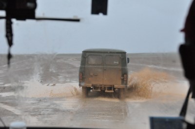
Atmospheric pressure. In winter, the major atmospheric phenomenon is the Asian (Siberian) anticyclone with the center in the north-west of Mongolia, reaching its maximum power in January [3]. In spring, the power of the anticyclone subsides, which makes dominant the factors of zonal circulation, conditioning the west-east transfer. Apart from the transfer of atmospheric entities from west to east, spring is marked with the arrival of cyclones from Central Asia. In summer, circulatory processes are characterized with the weakening of the west-east transfer. On the land surface, the baric field of reduced pressure with weak winds prevails (pic. 1.4.1).
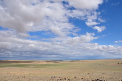
Pic. 1.4.1 The clouds over the Mongolian steppe
When the blocking warm anticyclone is located over the central regions of Yakutia, southern cyclones come from Mongolia to the area of Lake Baikal, moving subsequently to the west or north-west. Central forms of summer circulation occur under the intensive development of pressure ridges and troughs. Circulatory conditions in autumn are characterized with the formation of the general west-east transfer, interrupted by meridional intrusions of cold masses from the north. Siberian anticyclone is at the stage of inception. In comparison with the spring season, autumn west-east movements of baric systems occur slower. The final transition to winter conditions of circulation is due in mid-November, when the Siberian anticyclone becomes rather stable.
Air temperature. Within the territory of Baikal depression, climatic conditions of the surrounding areas are heavily influenced by Lake Baikal [3]. While climate of the inland territories of Irkutsk region, Republic of Buryatia, Zabaikalsky Krai and Mongolia can be considered as extremely continental, local climatic conditions of Baikal shore area are close to maritime climate. Temperature of winter months on the shore of south Baikal is on the average 5оС higher, and in summer months is as much lower than in the central areas. In summer time, temperature inversions are observed above the lake surface, impeding the ascending movements. The totality of radiological and circulatory factors and local conditions determine the peculiarities of the thermal regime.
In winter, due to the prevalence of anticyclone weather, air temperature depends mainly on the radiological conditions and air is cooled considerably above the surface. In summer, radiological factors play the dominant role in the formation of the temperature regime as well. The average long-term air temperature on most of the territory is below zero. The stations, located on the shore of Baikal, enjoy higher temperatures than the inland stations located on the same latitudes. The coldest month is January, the hottest month is July.
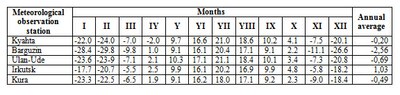
Spatial differentiation of temperature indicators within the basin is essential. Average daily temperature in the uplands does not reach 10 0С, and its total value varies from 2400 0С in the south of the basin to 500 0С on the north-eastern shore of the lake (табл. 1.3.2).
Table 1.4.2 Monthly averages of air temperature, °С (by meteorological station)
Atmospheric precipitation. The patterns of precipitation formation and distribution on the research territory are considerably influenced by the peculiarities of mountainous relief [3]. The altitude of the area and, more specifically, the location of mountains in relation to the moisture-carrying air currents make the distribution of precipitation highly uneven. The same altitudes of mountain ridges are characterized with different amount of precipitation (pic 1.4.2).
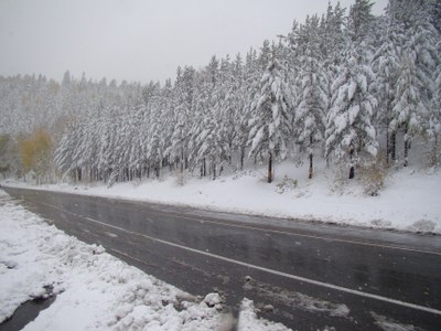
Pic 1.4.2 Snow on the mountain pass Mandrik
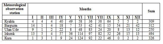
The maximum amount of precipitation is typical of the north-western and western slopes of the ridges, primary towards the prevalent air currents and bounding Lake Baikal – up to 1400 mm on the wind-faced slopes of the secondary ridges and in the interior regions of the uplands – 400-700 mm. In the grassland area of the western shore of Lake Baikal and its islands the amount of precipitation is 200-250 mm, in the intermountain depressions and valleys of the Uda and Selenga rivers – up to 300 mm (table 1.3.3).
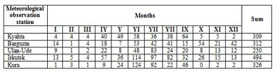
Table 1.4.3 Monthly and Annual precipitation, mm (by meteorological station)
Snow cover. Snow cover is formed unevenly [3]. Its height decreases from the north-east of Lena-Angara plateau (50-80 cm) to 5-10 cm on the vast plains of Transbaikalia and Mongolia. This is conditioned by the interaction of powerful northeastern air currents with the weakened Pacific currents as well as the rising amount of precipitation with increasing ratio of solid particles. This is why the snow level in valleys is not high, and in the mountains of Lake Baikal and Stanovoi mountain ridge rises up to 60-100 cm. Uninterrupted snow cover is characteristic of the whole basin of Lake Baikal, but because of the snow-storm transfer, it is distributed unevenly inside the depressions with inversions, on the windward and leeward slopes of mountains. On the windward slopes, the height of snow cover rises by 70 cm at 1500 m and by 125 cm – at 2000 m. On the leeward slopes of barren mountains snow cover constantly decreases to 7-12 cm at 2000 m. On the plains and coast of lake Baikal, its average altitude varies within the range of 30-40 см (pic. 1.4.3). The exception is the Mongolian plateau, where in February-March the snow level does not exceed several centimeters. One should note regional specificity of the snow cover formation. It is determined by the confrontation of humid air masses with the surface of mountain slopes. Passing over water surface, air masses are additionally saturated with water and enhance the amount of snow on the slopes.
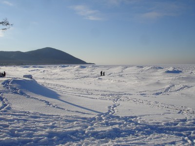
Pic. 1.4.3 Snow on the lake Baikal
Radiation regime. Meridional position of the sun changes in winter from 3º in the north to 17º in the south, and in summer from 50 to 64º; the duration of solar illumination varies from 4 hours in the north to 8 hours in the south, and in the south (due to the duration of day in high latitudes) from 21 to 16.5 hours [3]. The duration of solar illumination in Cis-Baikalia and on the shore of Lake Baikal is 1500 hours per year in the north to 2600 hours in the south, whereas in Transbaikalia – from 1770 to 3000 hours, respectively.
At the bottom of depressions, bounded by mountain ranges, in which the recurrence of fogs is significant, the duration of solar illumination diminishes by 300-500 hours. In this respect, the territory of Transbaikalia surpasses all the regions on these latitudes and even the well-known resorts of the Caucasus (in Kislovodsk – 2000 hours). The minimal amount of solar illumination is observed in November-December (22-100 hours) and the maximum amount – in May-June (240-280 hours), when the concentration of clouds is insignificant. The ratio of the observed solar illumination to the potential amount of illumination is 60-80% in February-March, 50-55% in July-August, 25-30% in November-December. Therefore, the sunniest period is the latter half of winter and spring, while the least sunny days are at the end of autumn and beginning of winter.
Biological impact of ultra-violet radiation on humans is only possible in the periods when the position of the sun exceeds 25-30º from February to October in the south of the territory. With the position of the sun exceeding 45%, the period of intense ultra-violet radiation occurs (75 days in the north and 165 days in the south), when under the excess of sunshine overheating of the human organism, sunburns are possible.
Overall amount of radiation in the south is 100-110 kk/sm2·year. The maximum value for radiation is in June (14-16 kk/sm2·month), and the least is in December. According to Budyko et al, theoretical values of radiation for these latitudes under the conditions of cloudless sky are considerably higher – in June 22-23 kk/sm2. Thus, high concentration of clouds diminishes radiation by 60-65%. In addition to the natural rise of radiation from north to south, one can observe some decrease in its intensity from west to east due to the increased intensity of clouds in Transbaikalia in the second half of summer.
Mongolia has an extreme continental climate with significant fluctuations of daily and seasonal temperatures [7]. The winter is typically long and cold, while the summer is warm and short. The central and northern parts of Mongolia are elevated above the sea level by about 1,580 m. The region is mountainous and Khangai and Khentii mountains located here as well as the mountains around Lake Khuvsgul constitute part of Syberian Great Taiga. The weather is bright on most of the days (pic. 1.4.4).
Pic. 1.4.4 The sun over Khuvsgul
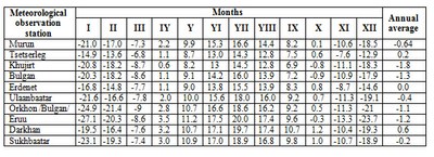
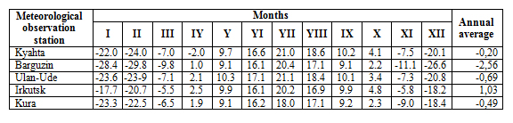
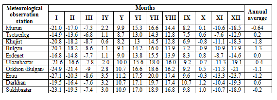
In 2012, the maximum recorded temperatures were 38.1-31.4°C and were recorded near the Ider River, in Khuvsgul mountainous region, Darkhad depression, Orkhon and Selenge river basin area [8]. The coldest temperatures observed in Orkhon and Selenge river basin were between -43.9 and -38.1°C, in Ider river basin, Khuvsgul Mountainous region and Darkhad depression the range was between -50.0 and -45.1°C, and from -41.5 to -32.5°C in other areas. The average air temperatures observed at meteorological stations in Selenge river basin are shown in table 1.4.4.
Table 1.4.4 Monthly averages of air temperature, °С (by meteorological station)
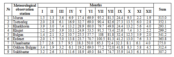
The annual average precipitation is around 200-350 mm in Khangai, Khentii and Khuvsgul mountainous region and Orkhon and Selenge river basins (pic. 1.4.5) [8]. The sum of the monthly and total annual precipitation recorded at meteorological stations in Selenge river basin are shown in the table 1.4.5.
Pic. 1.4.5 Rain in the Orkhon River Basin
Table 1.4.5 Monthly and Annual precipitation, mm (by meteorological station)
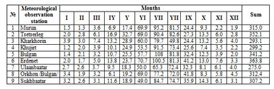
In 2012, the annual precipitation was 339.5-559.5 mm in Khuvsgul, Bulgan area and Orkhon and Selenge river basins. The surface water evaporation over the country is significant, particularly in forest steppe zones where evaporation reached 300-400 mm. In 2011, the annual average humidity was 64-79% in Khangai, Khentii and Khuvsgul mountainous region.
Annual average wind speed was 0.8-0.9 m/s in Bulgan area and 1.2-3.8 m/s in other areas, and the maximum wind speed reached 14 m/s in Jargalant area of Khuvsgul, Altanbulag area of Tuv aimag, and 15-34 m/s in other areas [8].
In Selengа River basin, prevailing winds change depending on the season. The winds from the north and west-north prevail in spring season (27%), winds from the east, north and west north are about 17-25% of winds in summer, while the east, west-north and south winds blow in autumn (16-20%). Winds from other directions are very rare. There are almost no winds in winter. In spring, summer and autumn, the average wind speeds are 3.0-6.9 m/s, depending on the direction. The annual average of wind speed is 2.7 m/s, not considering the direction.
Climate сhange. According to Ulan-Ude weather station over 103 years the warming of the climate is estimated by the air temperature growth by 2.5° C (fig. 1). At the same time in Novoselenginsk the average annual air temperature rose by 1.8° C, while in Kyakhta it rose by 1.6° C [15].
Global changes reflect in the length of seasons (fig. 2). Increases of spring, summer and autumn and, consequently, decrease of the winter period were established. If in the early 1970s the length of seasons with positive and negative temperatures was approximately equal to 180-185 days, in the early 2000s the length of period with temperatures exceeding 0° C amount to over 200 days [15].
According to the data of the Limnological Institute of the Siberian Branch of the Russian Academy of Sciences annual air temperature growth at Lake Baikal (1.2° C over 100 years) turned out to be twice higher than the globe’s average (0.6° C). This corresponds to the known fact of intensification of warming pace from low to middle to high latitudes. It may be expected that the annual air temperature at Lake Baikal by 2025 will rise by 2° C, and by 2100 by 4° C [17].
Reconstruction of hydrological regime show that over the recent 250 years the dynamics of precipitation and water level did not undergo significant (trend) changes. A growth of winter temperatures has not yet led to a drastic changes of hydrological budget of the Transbaikalian territory, where natural changes prevail. [15]. Cyclicity is the most characteristic part of the longstanding regime of annual run-off of the rivers of the Baikal region and changes in atmospheric precipitation.
From the middle of the last century average duration of snow cover in Transbaikalia shortened approximately by 5 days. This was caused by an increase of warm period duration connected with the increase of air temperature. The most significant decrease of the duration of snow cover is observed in the regions adjacent to Lake Baikal. On the contrary, in eastern regions the increase prevails. At the same time some precipitation enhancement during the cold season of the year results in a growth of snow cover depth. A tendency to increase is exposed in the longstanding changes of snow cover depth by 2-4 cm in average since the mid-1960s [13].
Climate change influences ice conditions on the lake. It is manifested in delayed freezing time and earlier breaking up of ice. At this time the change of freezing time in 1896-2000 was higher (by 11 days over 100 years) than for break up (7 days over 100 years) due to more active late autumn warming – early winter (November-December by 1.6° C) in comparison with the second half of spring (in April-May by 0.9°). The duration of an ice-free season increased, while that of the ice season decreased by 18 days. According to the observations, in 1949-2000 a maximum ice thickness in winter decreased by 2.4 cm over 10 years in average [16]. During the observation period from 1950 to 2007 a steady decrease of maximum ice-thickness on Lake Baikal amounts to 15-24 cm by different points. The duration of ice-formation decreased from 12 to 25 days for various areas of Lake Baikal and, consequently, the duration of ice-free period increased by 12-25 days [12].
According to forecasts the maximum ice-thickness on Lake Baikal will decrease to ~ 50 cm by 2050 and ~ 31 cm by 2100 [12]. Meanwhile the duration of ice season will decrease by 1 and 2 months respectively and by the end of the century will total 56-60 days on South and Middle Baikal and 76 days on North Baikal. It may be expected that in the end of the century in southern and middle areas of the lake there will be winters with short or unstable ice-formation [16].
The global warming affects Mongolia stronger in comparison with other regions of the globe. According to the data of 48 meteorological stations evenly spread on the territory of Mongolia, over past 70 years the average annual temperature in Mongolia rose by 2.14ºC. At the same time, in the period from 1990 to 2006 a small (-0.119ºC/year) temperature fall has been observed [18]. In the period from 1940-2004 winter air temperature rose by 3.6ºC, air temperature in spring rose by 1.4ºC, summer air temperature rose by 0.6ºC and autumn air temperature rose by 1.9º C. Climatic forecasts show that the territorial average monthly temperature of a warm season is expected to rise by 1.2-2.3º C in 2010-2039, by 3.3-3.6ºC in 2040-2069 and by 4.0-7.0º C in 2070-2099 [19].
Nowadays a gradual increase of evaporating capacity from the ground surface it taking place practically in all natural zones of Mongolia: in semi-arid and steppe and desert zone by 3.2-10 per cent, while in the highland and taiga areas by 10-15 per cent. Over the last 65 years the gross precipitation amount region-wise decreased by 8.7 – 12.5 per cent. Simultaneously, an annual redistribution of precipitation by seasons occurred. The winter precipitation amount rose while the precipitation amount in the warm season insignificantly fell. The amount of autumn precipitation rose by 5.2 per cent, winter precipitation rose by 10.7 per cent, while summer and spring rainfall, contrastingly, fell by 3.0 and 9.1 per cent respectively. This dynamics of humifying and the increase of the average annual temperature contributes to climate aridization [18]. Changes in rainfall will fluctuate approximately within ± 4% or 6-17 mm in the course of 2010-2039 with the expected rise by 7-8 per cent (27-33 mm) in 2040-2069 [19].
According to the research data gathered over the recent years changes in ice formation on rivers and lakes are concerned with the dates of ice cover formation and deterioration of condition and thickness of ice.
