2.3 Vegetation
2.3 Vegetation
The territory of Lake Baikal basin is part of the forest-steppe and forest taiga zone [3,4]. However, a considerable degree of territorial disintegration and the presence of intermountain depressions determined vertical zonality in the distribution of the vegetation cover. Within the area of the basin the following belts are distinguished: steppe, forest-steppe, mountain-steppe, goltsy-forest with cedar shrubs and goltsy belt.
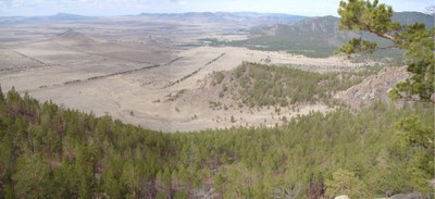
Goltsy belt stands out clearly on the ranges of Baikal mountain chain. The height of the lower level of the belt varies from 1100—1500 m in the north to1600—2000 m in the south. The goltsy belt is dominated by high mountain and wilderness landscapes. Vegetation of high mountain wilderness is represented by sparse low heather grass and lichen as well low heather shrubs. A characteristic feature of the goltsy belt is wide distribution of stone placers without vegetation (pic. 2.3.1). Comparatively small areas embrace portions of mountain tundra with shrub-lichen and small shrub-lichen vegetation. Barguzinsky range is abundant in the areas with mountainous sub-Alpine meadows (in the lower part of goltsy range). They do not constitute considerable land mass but alternate with the sections of mountain rocks and cedar forests, being located on the bottom of kar and in the upper part of trough valleys. Mountain meadows are characterized with dense and high grass (up to 40-60 cm) consisting of aquilegia, anemone and other species. Among sub-Alpine meadows one can observe portions of sedge-sphagnum and sedge wetlands.
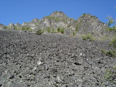
Pic. 2.3.1 Goltsy belt of vegetation, Barguzinsky range
Belt of goltsy forest and cedar shrubs is found above mountain taiga at the elevation of 1000-1500 m in the north and 1500-2000 m in the south. It takes comparatively small territory on the mountain ranges having flattened contours and flat tops, rising above the upper boundary of the forest. The mountain slopes are covered by cedar forests with a height from 0.5 to 2 m and goltsy sparse forest on the flattened sides. The latter is a sparse and depressed larch and cedar-larch forest with cedar shrubs, dwarf birch and other shrubs (pic. 2.3.2). The soil cover is dominated by lichen and occasionally moss (pic. 2.3.3). In some areas, where considerable and stable inversions of air temperature are observed, goltsy forests are found within the mountain-taiga belt (on the northern slopes of mountains, facing narrow shadowed valleys, on river and lake terraces.
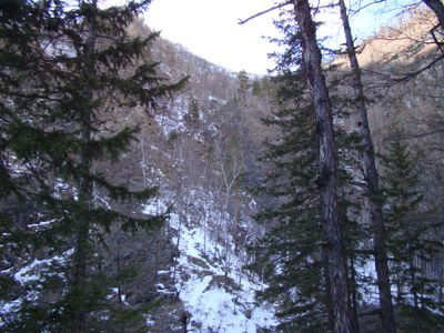
Pic. 2.3.2 Belt of goltsy forest and cedar shrubs on the Khamar-Daban range
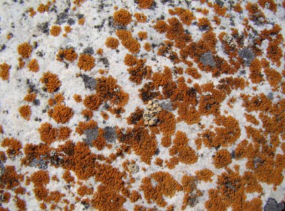
Pic. 2.3.3 Lichens on the Barguzinsky range
Mountain taiga is the most widespread landscape on the considered territory [3,4]. It takes up to about 70% of the Russian part of Lake Baikal basin and constitutes a bulk of its vegetation cover. The mountain taiga is mainly comprised by coniferous trees – Dahurian and Siberian larch as well as pine, cedar and in rare instances silver-fir and fir-tree. Of deciduous trees the most widespread species are birch and aspen. Depending on the latitudinal position of the place, the mountain-taiga belt occupies different altitudinal position. In the north, in the Verkhnyaya Angara basin, taiga is situated at an elevation of 460-600 to 1000-1500 m, and in the south at an elevation of 1000-1400 to 1500-1800 m. Along the coast of Lake Baikal, the lower boundary of taiga runs till the edge of water. The altitudinal position of the upper boundary of taiga depends on the exposition of mountain slopes. On the western slope of Barguzin range, facing Lake Baikal, the upper boundary of the forest is located at an elevation of 900-1400 m and on the better warmed eastern slope rises to 1400-1800 m.
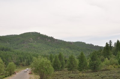
Mountain-taiga zone is divided into three altitude belts, corresponding to the southern, middle and northern taiga. Southern taiga is located to the south of 52° N below 1100-1200 m. It includes sparse larch-pine and pine forests with addition of birch. The underbrush is sparse and is dominated by dahurian rhododendron and spiraea. The soil cover incorporates shrubs and grass (pic. 2.3.4). Middle taiga is most widely spread. The major kind of tree is larch, other important species include pine, cedar and birch. In some portions, especially on the slopes of hills facing Lake Baikal, aspen, silver fir and fir can be found. The stand of trees is rather sparse, the underbrush is well developed and includes dwarf birch and dahurian rhododendron. The soil cover includes dense shrubs of red bilberry, blueberry and foxberry. Moss can also be found but it does not form a continuous cover.
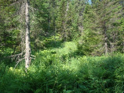
Pic. 2.3.4 The mountain taiga, the Khamar-Daban range
The composition of tree stand and underbrush changes depending on the slope exposition. Northern slopes have sections with depressed tree stand and dense underbrush of alder and cedar with a continuous moss cover. On the southern slopes, the tree stand is always better, pine tree is widespread, grass and shrubs are dominant in the soil cover. The belt of northern taiga is characterized by sparse and depressed tree stand, consisting of larch with the mixture of cedar. The underbrush always has cedar and dwarf birch trees as well as small-leaf rhododendron and alder. The grass and shrub layer includes wild rosemary, blueberry, red bilberry and sedge. The soil cover is dominated by moss while flat water-divide mountain tops have sphagnum. Forests in the mountain taiga zone protect soils from being washed away during snow melting and summer rain floods. Taiga protects soil from wind erosion, exerting a great impact on the conditions of snow cover formation. On the abrupt slopes, taiga reduces the risk of avalanches taking place.
Forest-steppe areas are usually bounded by the places with steppe vegetation (pic. 2.3.5). Baikal forest and steppe zone is commonly characterized by the alternation of steppe sections, lying on the southern slopes of mountains, with the deforested sections on the northern slopes [3,4]. The forest and steppe zone does not form a continuous belt and consists of disparate portions separated by mountain-steppe and mountain-taiga vegetation clusters. The sections of forest-steppe vegetation are located at an elevation of 900-1200 m. Forests of this belt are primarily sparse and are made up of pine, larch and birch; the underbrush is weakly developed or is gone. Steppe and forest-steppe areas are widely used in agriculture as plough lands, hay-making ground and pastures.
Pic. 2.3.5 The forest-steppe, Valley of Tugnui River
Steppes do not form a continuous landmass but incorporate separate sections, related with tectonic depressions and river valleys [3,4]. Two groups of formations are clearly distinguished – steppes of mountains and steppes of foothills, elevated plains and hummocky topography. In each of them one can distinguish two large ecological-morphological groups – meadow and dry steppes. For each of such groups one can distinguish separate regional steppe complexes – South Siberian, North Mongolian and Central Asian formations (pic. 2.3.6).
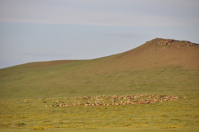
Pic. 2.3.6 The North Mongolian steppe
The upper border of the steppe does not rise above 900-1100 m. Dry steppes with hazel soils are characterized by the presence of low plants (average height is from 10-15 to 25-35 cm) and sparse density (with the project cover of 60-70%). Black humus soils have steppes with different herbs characterized by denser and higher grass level. Steppe plants have well developed root systems reaching the depths from 10 to 70 cm. Vegetation groups are quite diverse. Of gramineous plants, the most widely spread plants are mat-grass, cleistogenes, sheep fescue, meadow grass, and june grass [4,18]. Of wild grasses, widely present ones are tansy, potentilla, oxytrope, astragal, sedge, wormwood, pea shrub, etc. Saline soils typically have jiji grass and flag-leaf as well as salt grass and saltwort (pic. 2.3.7).
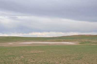
Pic. 2.3.7 The area of salinity in the Mongolian steppe
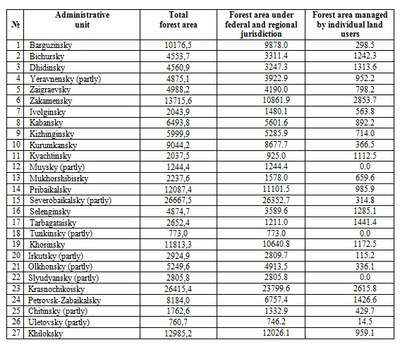
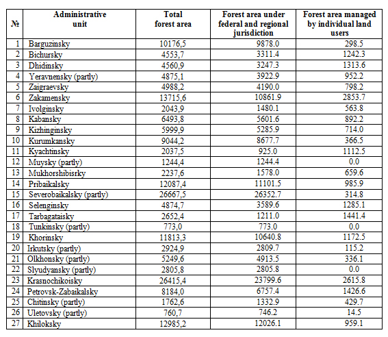
Forests. The total area of forested land within the Russian part of the Lake Baikal basin is 191982.5 km2, of which 169118.7 km2 is under the jurisdiction of the federal government and 22863.9 km2 is managed by individual land users (data of the digital topographic basis of BINM SB RAS) (табл. 2.3.1).
Table 2.3.1 Forest area within the Russian part of the Lake Baikal basin by administrative districts, km2
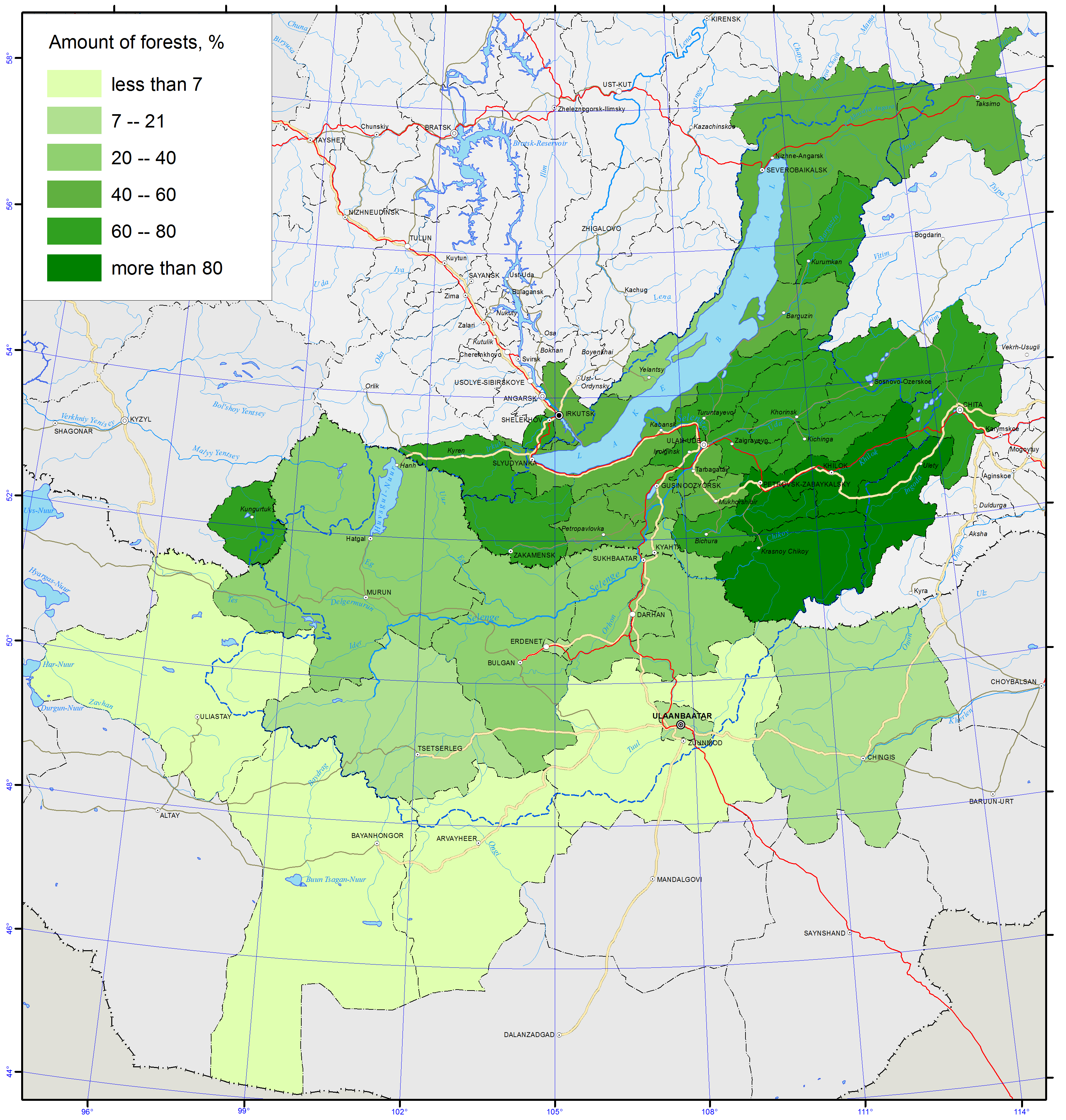
The total area of lands covered by forests in the Republic of Buryatia, including forest fund lands and other land categories, was 29638.4 thousand ha or 84.4 % of the total land area as of 01.01.2013 (pic. 2.3.8) [4,7].
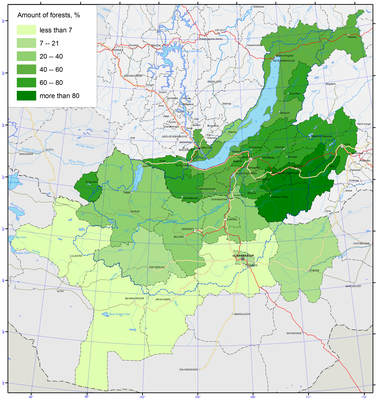
Pic. 2.3.8 Amount of forests of Lake Baikal basin [1]
The Republic Forest Agency is responsible for supervising the forests of the forest fund with the total area of 27010.3 thousand ha or 91.1% of the entire forest lands in Buryatia. In terms of use, forests are divided into 3 major categories: protected forests occupying 9308.1 thousand ha, exploited forests occupying 9436.4 thousand ha, and reserve forests occupying 8265.8 thousand ha.
Forests, not included in the forest fund, are the forests located on lands of other categories: forests located on the specially protected natural territories affiliated with the Ministry of natural resources and ecology of the Russian Federation – 2065.1 thousand ha (7% of all forests); forests, not included in the forest fund of the republic, are represented by the lands within human settlements with a total area of 29.6 thousand ha (0.1% of the forests), lands of other categories (lands of the water fund, land occupied by industries, reserve lands) with a total area of 85.1 thousand ha (0.3% of all forests) [7].
Mongolia’s forests are located in the transitional zone between the great Siberian taiga and the Mongolian plateau of grassland steppe (pic. 2.3.9). These forests play a critical role in preventing soil erosion and land degradation, in regulating the water regime in mountain areas, maintaining permafrost distribution, providing habitats for wildlife and preserving biodiversity. Even though Mongolia is a country with limited forest resources, there are more than 140 species of trees and shrubs and forests cover 12.9 million ha, which is about 8.2% of the total area of the country (pic. 2.3.8). According to the Law on Forestry approved in 2012, the lands already covered by forest and required for forest extension are determined as the forest fund [18,19].
Pic. 2.3.9 The coniferous forest in Mongolia
Forests are classified as strictly protected forests, protected forests, and utilization forests (pic. 2.3.10). Utilization forests are designated primarily for commercial timber harvest with contracts and the payment of fees required. The strict zone forest consists of sub-alpine forests, pristine and conservation zone forests within strictly protected areas, and special zone forests within national conservation parks.
The protected zone category is much broader, consisting of four sub-zones including certain forests within specially protected areas - national conservation parks, nature reserves, and monuments - as well as green zones around towns and villages, prohibited strips along riparian zones, national roads, and railways, and locally protected forests (pic. 2.3.10). Locally protected forests may consist of areas containing different forest types, including saxaul forests, oases, forest stands covering up to 100 hectares, forest groves, shrubs, sun-exposed forest areas, and forests on slopes steeper than 30 degrees.
Pic. 2.3.10 The locally protected forest
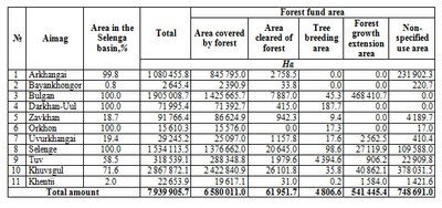
By 2012, the total area occupied by Mongolian forest fund was 18 592.4 thousand ha, of which 12 552.9 thousand ha were covered by forests. 75.4% of the total forest fund area is covered by coniferous and deciduous forests (pic. 2.3.11) and 24.6% by saxaul forests. 15.3 million ha of the forest fund area is the protected forest zone, and 10.8 million ha of this zone are covered by coniferous and deciduous forests and 4.5 million ha by saxaul forests. Every year the Government Implementation Agency reports the total forest fund area by administrative regions based on information from Geodesy and Cartography Agency and National Statistics Committee (table 2.3.2) [18,19,20].
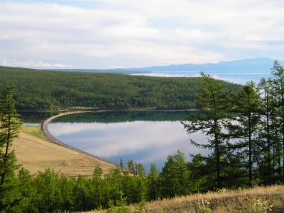
Pic. 2.3.11 The forest on Lake Khuvsgul
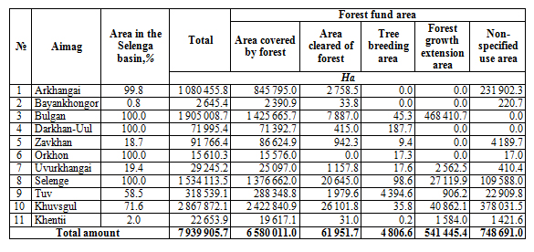
Table 2.3.2 Forest fund area in aimags within the Selenga river basin (2013)
The Selenga River basin in the northern part of Mongolia is covered by mixed forests (pine, larch, and cedar) and grassy plants (pic. 2.3.13). During the summer of 2013, Ministry of Environment and Green Development conducted a research expedition to catalogue endangered and beneficial plants. The expedition covered 17 aimags and various natural zones - forest steppe, steppe, and semi-desert steppe. The researchers have found and recorded 188 species of beneficial and 70 species of endangered plants growing in Khovd, Gobi-Altai, Uvurkhangai, Bayankhongor and Umnugobi aimags and 54 species endangered plants in Selenge, Orkhon, Bulgan, Arkhangai, Zavkhan and Tuv aimags. Among all these endangered plants, 23 were found and recorded in Khangai region.
According to the Mongolian vegetation list, there are more than 2 800 plant species in the country [19]. Among them, 382 species of plants can be used for food and drug manufacturing (pic. 2.3.12), 195 species of them need to be protected. Researchers have presented a list of 102 plants that have commercial value and recommended the ways the plants could be used. Ten species, such as licorice, ephedra, etc., are liable to illegal plant trade, eight more species were added into Mongolian endangered plant list, and 37 species require to be further inspected.
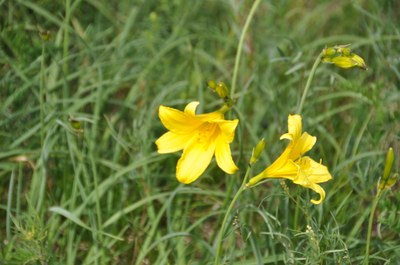
Pic. 2.3.12 Hemerocallis minor, the upper river Tuul
In Mongolia, there are 75 endangered species of medicinal plants, 20 species of which are on the brink of extinction [21]. Furthermore, in danger of extinction there are 11 species of food plants, 6 species of which are on the brink of extinction; 16 species of technical plants; and 55 species of ornamental plants, 5 species of which are on the brink of extinction.
