1.3 Specially protected natural territories
1.3 Specially protected natural territories
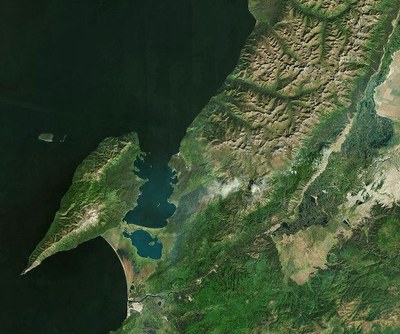
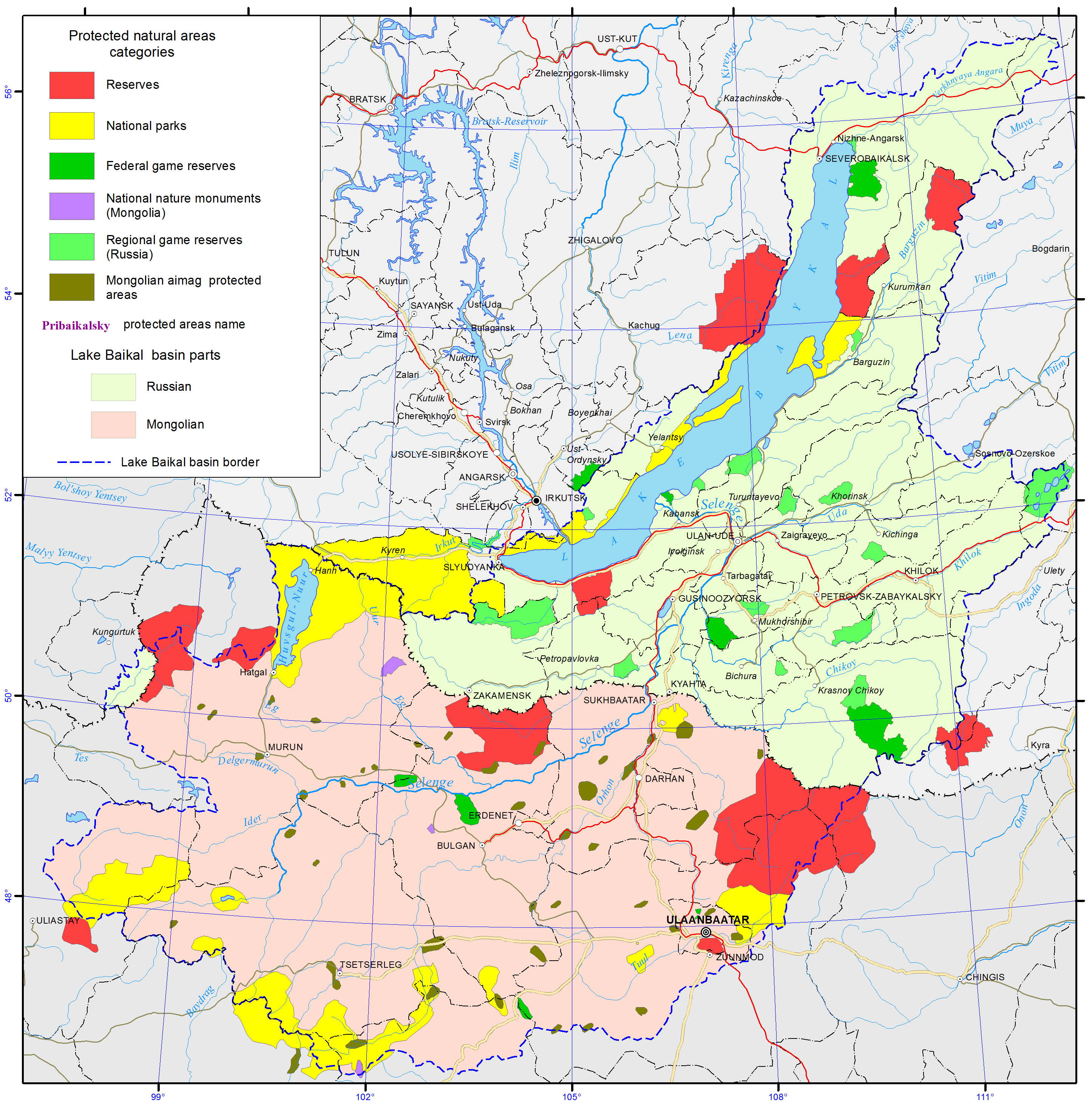
At present, the Russian territory of the basin incorporates all the major categories of specially protected natural territories (SPNT) distinguished by the federal law «On specially protected natural territories» (1995): state nature reserves, national parks and wildlife sanctuaries of the federal and regional level as well as resorts and recreation locations, botanic gardens and monuments of nature (pic. 1.3.1) [3,4]. The total area of SPNT within Russian part of basin is 31252 km2 (data of the digital topographic basis of BINM SB RAS). In 2013, the number of reported violations in protected areas compared with 2012 increased by 29% and amounted to 1 110 violations.
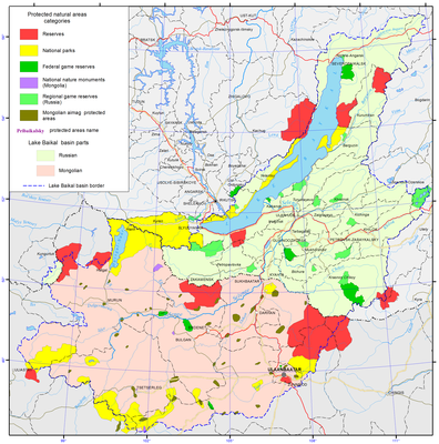
Pic. 1.3.1 The specially protected natural territories [1]
Reserves. Of the five state natural reserves three natural reserves are biospheric in accordance with the international UNESCO «Man and Biosphere» program: Barguzinsky (having a biospheric polygon), Baikalsky (pic. 1.3.2) and Sokhondinsky [3,4]. The boundaries of Barguzinsky reserve include a three-kilometer area along the coast of Lake Baikal. Sokhondinsky and Baikalsky reserves have protection zones – buffer territories, mitigating the transition from the strictly protected areas to the exploited areas. The reserves of the region preserve high-mountain taiga ecosystems: Baikal-Lena nature reserve preserves Baikal range; Barguzinsky reserve -Barguzinsky range, Baikalsky-Khamar-Daban mountains; Dzherginsky reserve – the juncture of Barguzinsky, Ikatskt and South-Muysky ranges; and Sokhondinsky reserve – Sokhondo mountains.
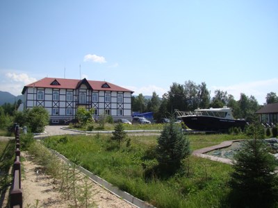
Pic. 1.3.2 The office of Baikal Reserve
The Baikal Natural Biospheric Reserve on the south coast of Lake Baikal is the major hub of the Eurasian ecological network and serves the research and nature conservation purposes. The biospheric reserve includes the Museum of Nature, which keeps its collection of animal and bird collection regularly updated (pic. 1.3.3).
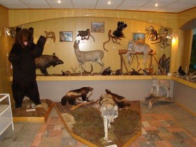
Pic. 1.3.3 The Museum of Nature of Baikal Reserve
The reserve also provides premises to the “Ethno-town” complex with a total area of 0.25 ha. In 2012, the museum managers conducted 61 excursions, while the number of museum visitors was 633 persons. The territory of the reserve is traversed with 6 ecological trails. The «Khamar-Daban Wilderness Trail» with a length of 12 km (2.5 km of which are within the protected area) passes through the Osinovka River and offers a good view of the bald mountain landscape. The path is reconstructed and maintained by volunteers of the «Great Baikal Trail Association» (pic. 1.3.4). The second excursion trail is designed as an ecological trail along the Vydrinnaya River and has a length of 44 km (22 km of which are outside the protected area). In 2012, the territory of the reserve and the protected area within it were visited by 357 groups of a total of 4 thousand people, as well as 25 foreign groups totally numbering more than 100 people.
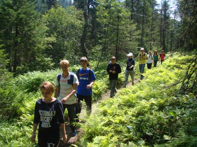
Pic. 1.3.4 The Great Baikal Trail
National parks. The region has four national parks being a type of specially protected natural territories more geared towards the development of tourism and recreational activities [3,4]. National parks are supposed to incorporate some of the following types of functional zones: a wilderness area, a specially protected area, a learning tourism area, a recreational area, and an area for historical and cultural objects. The functional zoning of national parks in Lake Baikal basin is different. For instance, in addition to the above-mentioned zones, Zabaikalsky National Park (pic. 1.3.5) has a defined water protection zone and a zone for traditional economic activities, where regulated fishing is allowed (6165 ha, or 2.7 %). Pribaikalsky park has a zone of traditional nature management (33 900 ha, or 8.1 %), but it does not have a specially protected area.
Pic. 1.3.5 The Zabaikalsky National Park (Google)
The territory of Pribaikalsky national park stretches over 600 km as a narrow strip along the southwestern coast of Lake Baikal. The park is composed of clusters of five separated sections: Olkhon Island, mainland Olkhon district area, Maritime range and Baikal range. The boundaries of Pribaikalsky national park embrace about 40 locations as well as 112 thousand ha of agricultural lands, some of which are disputed. In terms of agricultural land disputes, the situation is relatively successful at Zabaikalsky national park. Its territory is compact and access is easily regulated. A 2011resolution of the Ministry of Natural Resources and Ecology of the Russian Federation stipulated merging of Barguzinsky state reserve and Zabaikalsky national park into a single entity under the official name of «Zapovednoe Podlemorye».
Wildlife sanctuaries of the federal level. The territory of the three federation subjects have seven wildlife sanctuaries of the federal level, being located mainly on their peripheral part [3,4]. «Frolikhinskiy» wildlife sanctuary is situated on the northeastern coast of Baikal and on the western slope of Barguzinsky range. Lake Frolikha as a unique natural object, a habitat to endemic species of flora and fauna. Part of Lake Baikal coast, adjacent to the SPNT, belongs to the protected area of the sanctuary. The water-spa resort «Khakusy» is part of the wildlife sanctuary.
«Kabansky» wildlife sanctuary is located in the Selenga river delta and is recognized as a structural part of Baikal biospheric reserve (pic. 1.3.6). The sanctuary incorporates aquatic and semi-aquatic complexes of multiple water channels and wetlands. This area is considered as an internationally significant territory with the status of «key ornithological territory» recognized by the Convention on the Conservation of Migratory Species of Wild Animals as well as the Convention on Wetlands of International Importance (Ramsar Convention). The reason for that is that the sanctuary is the major node on the migration trajectory of the birds of passage, many of which are numbered as rare or endangered species (pic. 1.3.6).
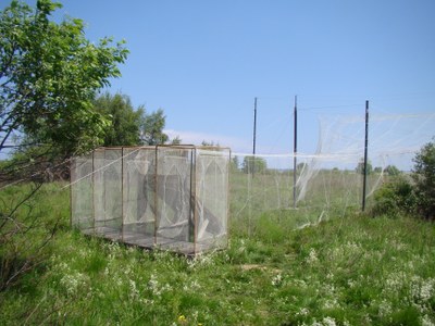
Рис. 1.3.6 The trap for birds
«Altacheisky» wildlife sanctuary is at the confluence of the rivers Sulkhara and Khilok (right-hand tributary of the Selenga River) and represents a transition between middle-mountain pine forest and typical Selenga dry steppe area. The main protected species are roe deer, Siberian stag, bustard, demoiselle crane and Daurian hedgehog.
«Burkalsky» wildlife sanctuary is centrally located amid Khentei-Chikoi mountains and preserves cedar (Siberian larch) taiga. The population of Chikoi sable is endemic to this place, which unlike Barguzin sable has darker fur and is bigger in size.
Wildlife sanctuaries of regional significance. Irkutsk region numbers 12 wildlife sanctuaries of regional significance (nine of them are of comprehensive character, while Zulumaisky, Irkutniy and Kochegarsky are species-oriented). In the Republic of Buryatia, there are 13 sanctuaries all of which have the status of «state natural biological» entities. In Zabaikalsky Krai there are 15 sanctuaries [3,4]. This category of SPNT is affiliated with the special departments of the executive power of the federation subjects. According to the federal legislation, such sanctuaries are established for a definite period, after which the decision on the prolongation or abolition is to be made. It should be noted that at present all the wildlife sanctuaries of Irkutsk region have been made to exist for an unlimited period of time. In Irkutsk region, some wildlife sanctuaries (Irkutniy, Magdansky, Kochergatsky and Boyskiy wetlands) have been functioning this way from 2003, while all other sanctuaries assumes the status in 2008. The Republic of Buryatia abolished time limits for wildlife sanctuaries in 2005, and Zabaikalsky Krai in February 2009.
Most of the wildlife sanctuaries of Irkutsk region cover river valleys and lake depressions of the middle-height mountains as hubs on the migratory routes of hoofed animals, nesting places of commercial birds, including semi-aquatic and swimming birds. In Buryatia, coastal SPNTs near Lake Baikal include Verkhne-Angarsky (the Kichera and Upper Angara river deltas), Pribaikalsky and Enkhelukskiy wildlife sanctuaries; high mountain-taiga type SPNTs include Muyskiy, Snezhinsky, and Ulyunsky (serves as a protection zone for Zabaikalsky national park); mountain-taiga SPNTs include Angirsky, Kizhinginsky, Kondinsky, Uzkolugsky, and Khudaksky sanctuaries; steppe SPNTs are Tugnuisky and Borgoisky. In Zabaikalsky Krai mountain-taiga sanctuaries include Atsynsky, Butungarsky, Nikishinsky, Uldurginsky and Chitinsky. A significant part of Ivano-Arakhleisky wildlife sanctuary is made up of lake and wetland complexes.
Monuments of nature are the most numerous group of SPNTs, but these territories are insignificant in size and least protected legally [3,4]. In many cases, monuments of nature are seen as being supervised by non-existent organizations such as collective farms. Irkutsk region numbers 75 monuments of nature, including 4 of the federal level, 28 of the regional level and 43 of the local level. Out of the two latter groups, 23 monuments of nature are geological and geomorphological, 18 are hydrological, 9 are botanical, 4 are zoological, 5 are landscape monuments and 12 are complex. Monuments of nature also included archeological monuments, even though these objects are supervised by the state bodies responsible for the preservation of historical-cultural legacy but not by nature-protection bodies.
In the Republic of Buryatia, all the 152 monuments of nature have the regional status. The following types of them are distinguished: geological – 43, hydrological – 53, botanic – 19, zoological – 9, landscape – 19, complex (including natural-historical) – 9.
In Zabaikalsky Krai, the total number of monuments of nature of regional level is 66, including geological – 21, hydrological – 17, botanic – 9, zoological – 1, and complex (including recreational and natural-historical) – 18.
Mongolian Law on Specially Protected Areas provides for four categories of protected areas, such as «Strictly protected area» (SPA), «National conservation parks» (NCP) (pic. 1.3.1 and pic. 1.3.7), «Natural reserves» (NR) and «Monuments» (NM) [10].
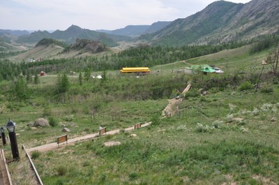
Pic. 1.3.7 The National conservation park Gorhi-Terelj
As of 2012, 99 locations covering 27.2 million ha are considered as specially protected areas. These areas occupy 17.4% of the country’s total territory and are to be further expanded to reach 30%. According to the classification of the specially protected areas, there are 20 Strictly Protected Areas occupying 12 402 429 ha of land, 32 Natural Conservation Parks spanning over 11 711 815 ha, 34 Natural Reserves covering 2 958 142 ha, and 13 Monuments over 126 848 ha. Mongolian Government further increases the number of Specially Protected Areas year by year [11].
Eleven Mongolian lakes and the areas surrounding them (wetlands, meadows, etc.) are registered under RAMSAR convention [14,24]. Among these, Lake Ugii (47º46’N 102º46'E) located in Ugii soum and Lake Terhyn Tsagaan (48°10'N, 99°43'E) located in Tariat soum of Arkhangai aimag were registered under RAMSAR convention in 1998.
The Orkhon valley with its numerous archaeological remains dating back to the 6th century was recognized as a World Heritage Site by UNESCO in 2004 [9]. Collectively the remains within the valley reflect the symbiotic links between nomadic, pastoral societies and their administrative and religious centers, and the importance of the Orkhon valley in the history of central Asia. The site includes Kharkhorum, the 13th- and 14th-century capital of Chingis (Genghis) Khan’s vast Empire (pic. 1.3.8). Within the cultural landscape are a number of archaeological remains and standing structures, including Turkic memorial sites of the 6th-7th centuries, the 8th-9th centuries’ Uighur capital of Khar Balgas. Erdene Zuu, the earliest surviving Mongol Buddhist monastery, Tuvkhun Hermitage, etc.
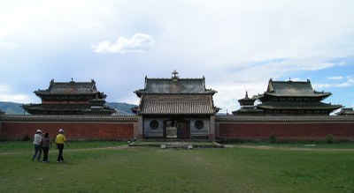
Pic. 1.3.8 The modern Erdenezuu in Kharkhorin
