1.1 Physical and geographical position
1.1 Physical and geographical position
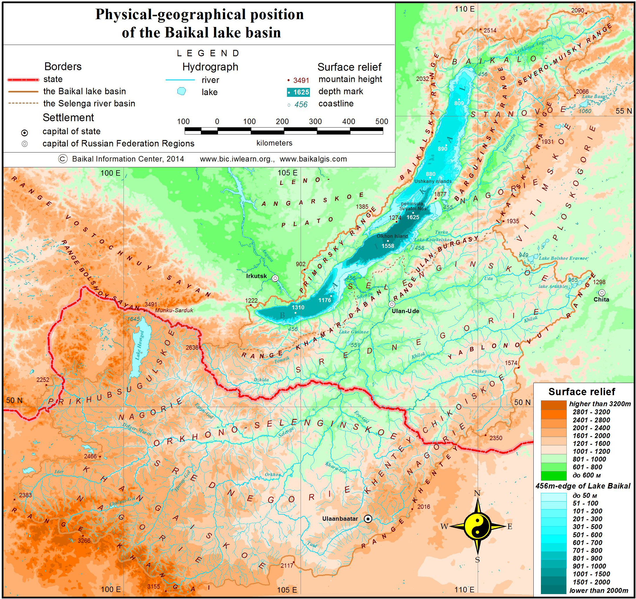
The transboundary basin of Lake Baikal is located on the boundary of North and Central Asia between 46º 28′ and 56º 42′ in the north-south direction and between 96º 52′ and 113º 50′ in the west-east direction. The longest stretch of the basin from south-west to north-east is 1470 km, from west to east it is 962 km, and its minimal length from west to east is 193 km. In the north, the basin is conterminous with the Lena river basin, bounded by the mountain range of Synnyr, Verkhneangarsk and Delun-Uransky. In the east, it is bounded by the Vitim uplands and the border is formed by the Ikatskiy mountain range. In the south-east, it borders the Amour river basin, where the water divide is constituted by the Yablonovy mountain range and is coextensive with the World watershed, separating surface waters of the Arctic Ocean and the Pacific Ocean, extending into the Khentei Mountains (World watershed). In the south, the basin is bounded by the inland drainage area of North Mongolia, while its south-western border is the formed by the Khangai range (World watershed). In the west, it is conterminous with the upper stream of the Yenisei and Lena rivers. At this point, the watershed line is coextensive with the state border and the Khangarulsky range, traversing the Khamar-Daban Mountains and reaching the outlet of the Angara River along the shore of Lake Baikal, extending along the Primorski and Baikal ranges (pic. 1.1.1).
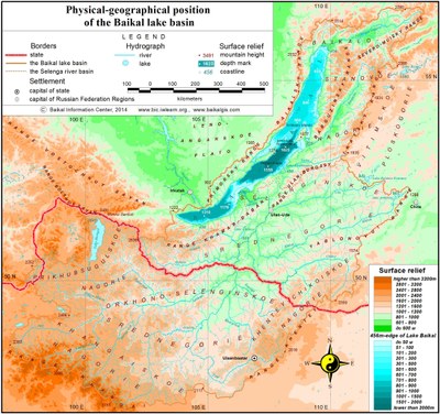
Pic. 1.1.1 Physical and geographical position of Lake Baikal
The territory of Lake Baikal is considerably elevated above sea level and is characterized with mid-mountain relief. The lowest elevation point is that of Lake Baikal - 456 m (Baltic system of altitude), and its highest point is Munku-Sardyk (3491 m). The land surface of the region is the ancient folded area, encompassing huge mountain ranges and vast, deep and in some cases isolated intermountain depressions. It is composed of ancient crystalline rocks, which are in some sections (predominantly in tectonic depressions) covered with a comparatively small (up to 0.5-2 km) layer of Mesozoic and Cenozoic deposits. Regional tectonics structure exerts considerable influence on the formation of relief and the regime of surface and ground waters. The rift area is the major element of the basin, incorporating the northern, central and southern depressions, filled with water and constituting the single Baikal depression (pic. 1.1.2). It is surrounded by mountain ranges, has a crescent-like form and stretches from the south-west to the north-east. The length of the lake is 636 km, and its width varies from 25 to 80 km. The average depth of the lake is 758 m, while its maximum depth is 1637 m.
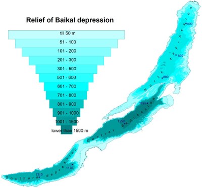
Pic 1.1.2 Relief of Baikal depression
Flat surfaces on the territory of the basin can only be found in tectonic depressions and the valleys of big rivers, which can in turn be divided into two major types - intramountanous (depressions of Baikal type) and intermountanous (depressions of Trans-Baikalian type) [1]. The depressions of Baikal type (Baikal, Verkhneangarsk, Barguzin, and Khuvsgul), formed as a result of curved deformation of the earth crust, are comparatively deep and large in size. Their northern and north-western sides are usually steeper. The depressions are filled with Cenozoic sediments, accumulated under the conditions of crustal warping. It is for this reason that rivers, flowing across this territory, have well-shaped and broad flood plains. The most significant of them is the one of Lake Baikal as well as Verkneangarsk and Barguzin depressions.
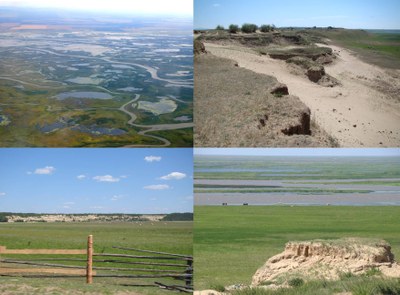
The depressions of Trans-Baikalian type have predominantly a tectonic and erosion-accumulative origin, while their number is more than 50 (Gusinoozerk, Ust-Selenginsk, Tugnui-Sukharisnk, Ivolginsko-Udinsk etc). They are surrounded by plateau mountains, which have at their base flattened and gently rugged foothills, separated by proluvian valleys. The submontane strips of the valleys embrace isolated mountains, low conic hills and small mountain groups. Some sections of the Selenga basin at the sabulous and sandy sites incorporate a dense network of ravines and are dominated by the eolian relief (dunes and deflation basins) (pic. 1.1.3).
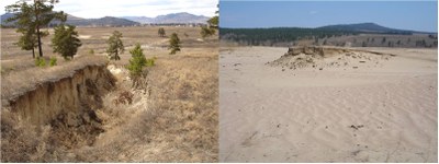
Pic. 1.1.3 Elements of eolian relief in Ivolginsk-Udinsk depression: ravines and deflation basins
Mid-level and high terrains in the Trans-Baikalian depressions are gone, low terrains are composed of gravel and sandy soil, while the terrain steps, cut by rivers, as well as subaerial deltas of tributaries and foothill shelves are composed of sandy and sabulous material. Trans-Baikalian depressions include the big fresh-water Lake Gusinoe – the third biggest lake in the basin in the center of Gusinoozersk depression, as well as the major rivers of the area (pic. 1.1.4).
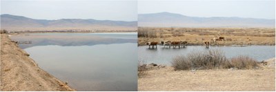
Pic. 1.1.4 Lake Gusinoe
Of special significance is Ust-Selenginsk depression, located in the tectonic downwarp area, protruded into the south-eastern shore of Baikal rift zone (pic. 1.1.5). It is characterized with active neotectonic processes. The depression is filled with a huge layer of loose sediments, while its ground waters are connected with Lake Baikal water by a hydraulic way at the depth of 200-250 m.
Рic. 1.1.5 Ust-Selenginsk depression
According to the geographic zoning scheme of IG SB RAS, the northern part of Lake Baikal basin is situated on the territory of Baikal Dzhugdzhursky mountain-taiga area, the middle part – on the territory of South-Siberian mountain area and its southern part – on the territory of North-Mongolian semi-desert and grassland area [2]. The relief of the basin territory is constituted by the following geomorphological formations:
1. Baikal-Stanovoe uplands;
2. Selenga middle mountains;
3. Orkhon-Selenga middle mountains
4. Khentei-Chikoi uplands;
5. Lake Khuvsgul uplands;
6. Khangai uplands.
Baikal-Stanovoe uplands incorporate those parts of the Siberian platform which are highly elevated and greatly dissected as a result of neotectonic movements. The heights of some mountain ranges range between 2000-2500 m, while the elevation of the depression bottom above sea level is 456 – 600 m. The highlands have significant traces of mountain-valley glaciation with the glacial forms of relief and a great number of lakes (pic. 1.1.6).
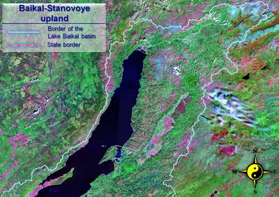
Pic. 1.1.6 Baikal-Stanovoe uplands (Landsat space image)
In the west, Baikal depression is bounded by the Primorsky range (with the heights ranging between 1100-1700 m), which does not have clear-cut water divide, but rather softly-shaped or flat peaks with incised valleys. To the north-east lies the heavily dissected Baikal range with mountain heights of 2000-2500 m. To the north, broadening in width to 80-100 km, it grows into the Ungdar highlands. Starting from the highlands, Verkhneangarski mountain range runs in the north-eastern direction (above 2000 m) (pic. 1.1.7) [3].
Pic. 1.1.7 Verkhneangarski range
In the east, parallel to the northern part of Baikal depression, run the Barguzin and Ikatsky ranges, between which lie Barguzin depression. The Barguzin range is the highest one among the highlands in the region (the height of some peaks reaches 2500-2840 m). Its distinctive feature is a strongly pronounced asymmetry: its southeastern slopes end abruptly towards Barguzin depression, and northwestern slopes run gradually to Lake Baikal (pic. 1.1.8).
Pic. 1.1.8 Spurs of Barguzinsky range
Barguzin depression has the length of about 200 km, while its maximum width is 25-35 km. The bottom of the depression is characterized by a flat relief (with elevation of 470-600 m), at the foot of which runs a foothill terrace.
The southern part of the range belongs to the zone of the specific Trans-Baikalian pine-larch (more rarely – birch) mountainous forest-steppes. The northern part of the upland is a typical mountain-taiga area.
The whole territory is a permafrost area. The southern part of the depression belongs to the zone of insular permafrost, while the northern (in particular the intermountain basins) – to the glaciation zone with the width of up to 120 m. The upland is characterized by increased tectonic activity and high seismicity.
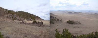
Selenga middle mountains are a huge lowered area between the Khamar-Daban, Ulan-Burgasy and Khentei-Chikoi ranges and bounded by the water divide of the Selenga basin (pic. 1.1.9) [1]. The peneplainized Khamar-Daban is a relatively flat plateau with the elevation of up to 1500 m, has the direction from the south-west to the north-east. The more prominent elements are massive round-shaped tops, exceeding 2700 m above sea level. To the south lies the middle-mountain Minor Khamar-Daban with the heights below 1700-1800 m, being heavily dissected by the many tributaries of the Dzhida River. The Dzhida range, made up of mid-level mountains with the maximum elevation of 1612 m above sea level, extends in the west as far as the Selenga river valley.
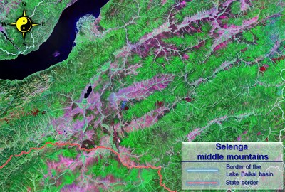
Pic. 1.1.9 Selenga middle mountains (Landsat space image)
The relief of the territory incorporates a considerable number of open, isolated and half-isolated depressions of Trans-Baikalian type, alternating with vast flat-topped ranges slightly varied in height (1300-1800 m). The intermountain depressions of Trans-Baikalian type are comparatively shallow, stretching in the same direction as the mountain ranges. The bottom of the depressions is at about 550-700 m above sea level in the western and central parts, and 700-850 m in the eastern part. The elevation fluctuates within 500-900 m. The depressions are relatively small in size, but their total area is rather large (pic. 1.1.10).
Pic. 1.1.10 Tugnuy-Sukharinskaya depression
Since intermountain depressions are bounded by the Khamar-Daban in the west, and the Khentei-Chikoi range in the east, and are open to the south, they receive just a small amount of precipitation, while their snow cover is thin and is not always formed in the driest regions.
The piedmont river fans, occupying a considerable part of the depressions’ bottom, have in their western section steppe and dry-steppe environment, and in their eastern section – forest and steppe environment. The more widely distributed are dry sod grasslands on chestnut soil and less widely distributed – bunchgrass steppe as well as forb and grassland on leached chernozem. The grassland belt has the elevation of up to 900-1000 m, forest and grassland – from 900-1000 to 1200 m. The lowest belt of the vertical zonation is the grassland-forest of the Selenga delta.
The bottoms and slopes of the depressions house dry pine forests. Considerable in size, the fluvial meadow plains and terraces as well as meadow-swamp plains are characterized by salination. The slopes of the ridges, facing south, are commonly covered by pine and pine-larch south-taiga forests, which include meadow-grassland plots – “uburs”. The northern slopes are grown by larch taiga, while the upper sections of the slopes (at the elevation of 1400-1600 m) one can find larch-cedar and cedar taiga. The middle mountains of the Selenga are the most economically advanced region of Lake Baikal basin.
Orkhon-Selenga middle mountains (Orkhon-Selenga erosion mountains) occupy a transitory area of the depression, located between the Khantai and Khentei-Chikoi mountains [4]. Territorially, this depression is coextensive with the heavily dissected basins of the Selenga and Orkhon rivers. The total length of the Orkhon-Selenga Mountains from east to west is about 1000 km, and its width – 300-350 km. This vast area consists for the most part of orographically branched and predominantly low mountains with unequal height. The area is dominated by low and narrow heavily flattened ridges and hills, separated by wide intermountain depressions and river valleys (pic. 1.1.11).
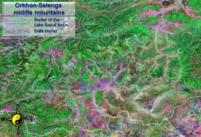
Pic. 1.1.11 Orkhon-Selenga middle mountains (Landsat space image)
The average height of the Orkhon-Selenga mountains is 1500-2000 m, and their maximum height is 2132 m (the Khantai range), while the bottom of depressions and valleys reaches the elevation of 800-1200 m. The landscape of low and heavily destructed mountains is dominated by the big range of the Khantai, Bulgan-Khan, Burin-Nuru and Burelyin-Nuru, with the heights up to 1600-2000 m. They occupy the extreme northeastern part of the Orkhon-Selenga mountains, adjacent to the Khentei range and extending in the same north-eastern direction. The other part of the Orkhon-Selenga mountains, gravitating towards the Khangai range, is considerably lower in elevation and is composed of heavily dissected low-height massifs, ridges and mountains (pic. 1.1.12).
Pic. 1.1.12 The Suvarga Khairkhan mountain, origin of the Orkhon River
Khentei-Chikoi uplands are on the Russian-Mongolian border and, for the most part in north-eastern Mongolia, where the ranges and depressions do not have considerable length [4]. Khentei-Chikoi uplands are typical low and flattened vault-like uphills with the barren relief on top of the vault (pic. 1.1.13).
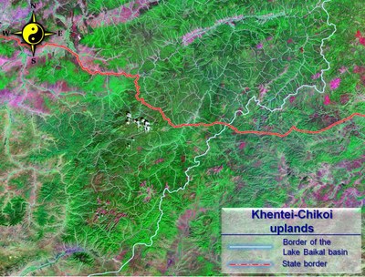
Pic. 1.1.13 Khentei-Chikoi uplands (Landsat space image)
This area lacks the single pronounced orographic core, but instead has a zone of bald mountains which assume the functions of the orographic core. The latter takes up the most elevated central part of the highlands, located in the upstream of the Onon, Tuul, Iro, Kherlen and Menza rivers. The bare mountains and ridges are commonly huge and have round-shaped or flattened tops, while their slopes, round-shaped and asymmetric, are covered with stones (pic. 1.1.14).
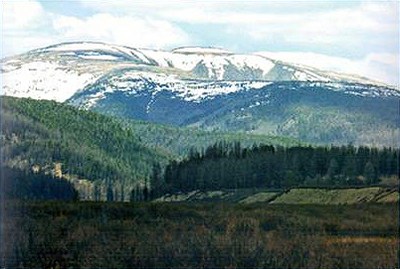
Pic. 1.1.14 Khentei mountain range
Of particular interest is the fluvial network of the highlands. Even though the rivers, originating in the barren mountains, flow in different directions, but none of them flows beyond their realm to the south – drainless Central Asian basin. All of them flow either into the basin of the Arctic Ocean, or the basin of the Pacific Ocean. Apart from that, some of them form abrupt and characteristic meanders and loops close to the boundaries of the drainless basin (Tuul, Kherlen). The world water divide in Khentei is not always coextensive with the maximum relief elevation, being second to the local water divides and forming a sinuous line.
The area is dominated by mountain taiga. The lower sections of the hills are taken by larch forests with the underwood of Rhododendron dauricum. At the heights, exceeding 1200-1300 m, larch forests are supplanted by cedar and larch forests. Purely cedar forests are rare and found predominantly at upper edges of mountainous taiga and damp places. At the height of 1700-1800 m, the sparse forest and barren mountains come to the fore. The upper stream of the Chikoi River has separate sites, the formation of which has been facilitated by glaciers. The most elevated places may have snow fields. The highlands also have permafrost of the island type.
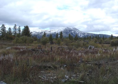
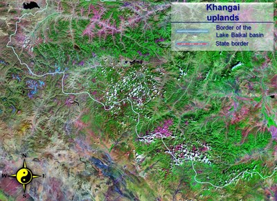
Lake Khuvsgul uplands form the southwestern node in the system of Baikal rift, ending without further visible extension [4]. The highlands protrude deeply into the mountain systems of Tuva and Eastern Sayans, forming a complex structural and orographic node, connecting their spurs with the spurs of the Khangai (pic. 1.1.15).
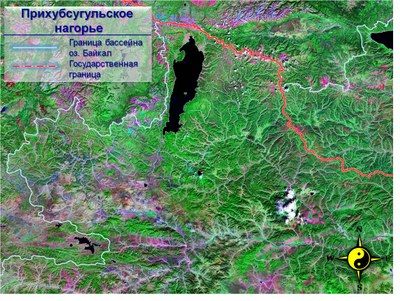
Pic. 1.1.15 Lake Khuvsgul uplands (Landsat space image)
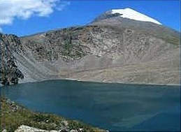
Khuvsgul uplands are represented by a number of mountain ranges and intermountain depressions, occupied by the valley of the Uree-Gol River, Lake Khuvsgul depression and Darkhat depression. The position of these depressions and ranges is strictly conditioned by submeridional rift, cutting across the extension of the sublatitudinal formations of Khangai mountains. Lake Khuvsgul serves as the orographic center of the area (pic. 1.1.16).
Pic 1.1.16 Lake Khuvsgol
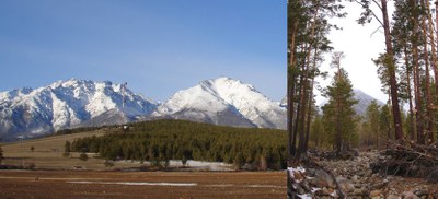
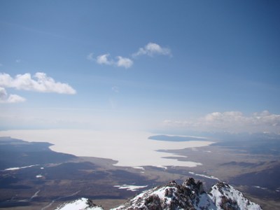
North of the lake runs the borer-area range of Munku-Sardyk, whose tops are permanently covered with snow and small modern glaciers. Along the western shore of lake Khuvsgol lie the huge and hard-to-access ranges of Bayan-Ula (3002 m) and Khardyl-Sardyk (3189 m), forming the boundary of the basin here. For the most part they exceed the elevation of 2000 m and have a relative elevation up to 500 m. Lake Khuvsgul rift area is the only mountainous area in Mongolia, which has a well pronounced Alpine relief (pic. 1.1.17).
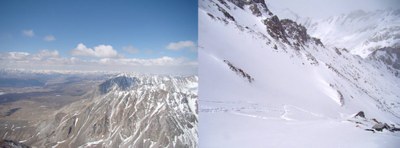
Pic. 1.1.17 Top of Munku-Sardyk
The slopes of the ranges, facing Lake Khuvsgul (Bayan-Ula range) and Darkhad depression (Khardyl-Sardyk range), form high and steep stone benches with the relative high elevation of up to 500-1000 m over Lake Khuvsgul. The southern part of the area has a mid-mountain relief, characterized with relatively flat tops of dividing ranges, comparatively flat and smooth slopes and wide valleys.
Khangai uplands are located in the southern part of the basin, forming the peculiar inland mountains of Mongolia. In the west, their slopes stop at the Great Lakes Depression, and in the south and the southeast at the Valley of the Lakes and the Central Gobi pereplain (pic. 1.1.18) [4]. The boundaries of the mountain area are clear-cut and distinct, conditioned by the deep faults of Dzabkhansky and Bayankhongorsky. The transition to valleys is marked either with benches, or the ridges of low mountains and hummocks, protruding deeply into their realm.
Pic. 1.1.18 Khangai mountains (Landsat space image)
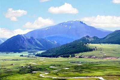
The orographic core of the area is its main water divide range, which stretches in the northwestern direction for 700 km and is coextensive with the World water divide. It reaches the maximum elevation in the west, where there is the most powerful mountain plexus with the well-preserved ancient glacial relief. The largest of them is the mountain group of Otgon-Khairkhan-Nuru. Its top Otgon-Tenger, 4008 m high, permanently covered with snow, is the highest mountain of the Khangai (pic. 1.1.19).
Pic. 1.1.19 The Otgon Tenger Mountain, origin of the Ider River
The northern slope of the Khangai forms vast foothills, deeply indented with the dense river network. Apart from the washed-out and peneplainized spurs of the main range, the area abounds in closed lake depressions predominantly with small, and more rarely large water bodies, which imparts this indented and flattened area the character of lake plateau and lake peneplain. In the latitudinal direction it is traversed by the aforementioned asymmetric ranges of the Tarbagatai and Bolnai, which underwent a considerable elevation.
