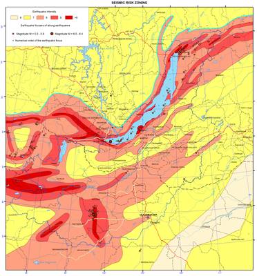
007. Seismic risk zoning map
007. Seismic risk zoning map
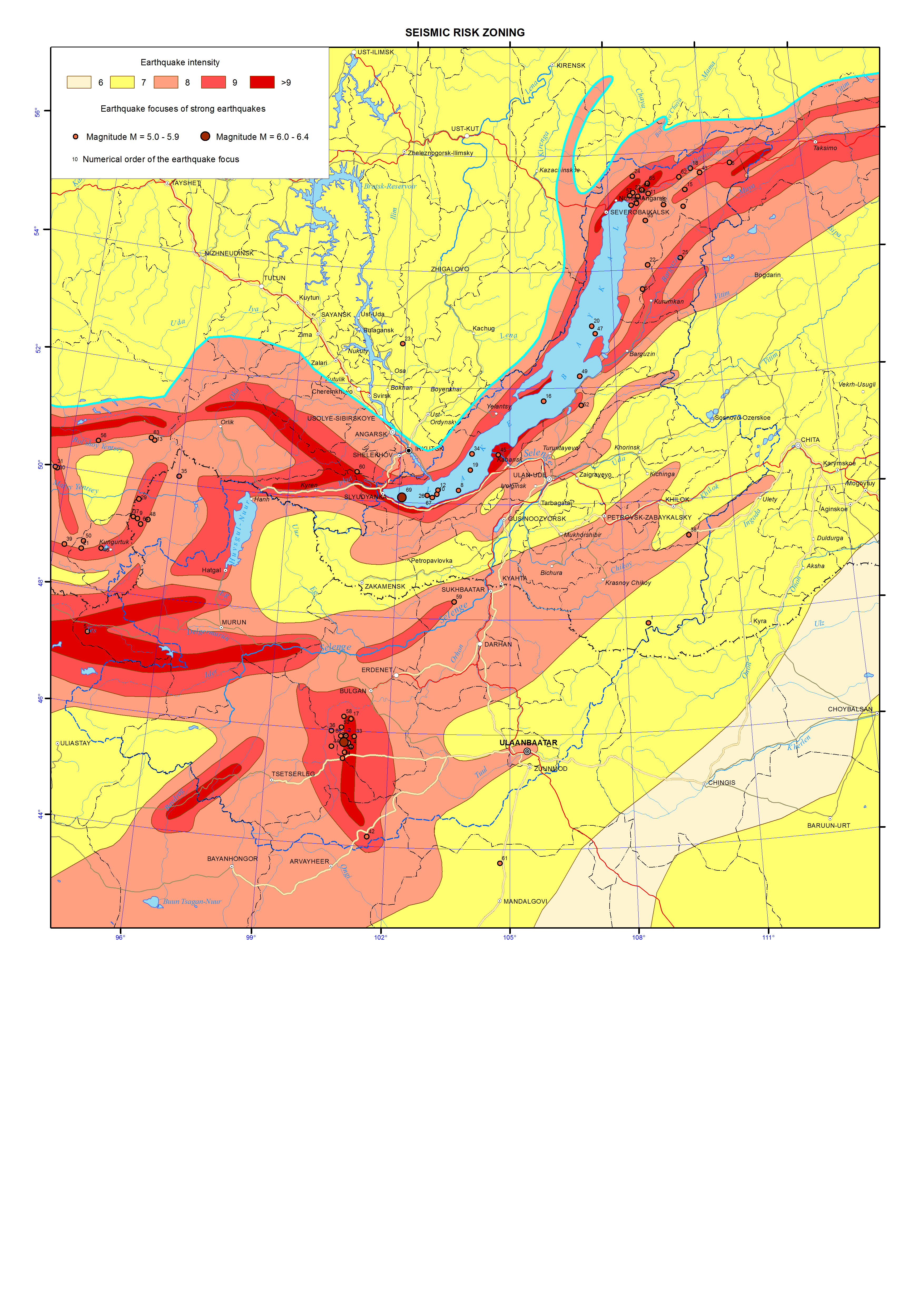
Seismic zoning. Epicenters of strong earthquakes
Seismic zoning implies mapping of seismic risk due to maximum seismic impact, which might originate over this area and be exceeded with a certain probability during the assigned time interval [Ulomov and Bogdanov, 2013].
Total seismic zoning (TSZ) is implemented on the basis of studying regional and global seismicity-generating structures (SGS), determining recent geodynamics, seismicity and seismic regime over territories of states. TSZ serves as the foundation for a rational land use and securing the antiseismic construction. To specify the degree of seismic risk in appropriate regions and over the local areas the supplementary field surveys are performed, including instrumental surveys.
The map of seismic zoning over the territory of the Lake Baikal catchment area depicts the materials collected through a systematic study of active faults within the territories of Cisbaikalia and Mongolia, where the strongest earthquakes might be the case. This type of mapping is methodologically based on the geological and geophysical evidence specifying the features of seismic and tectonic development of the territory including the elements of historic-structural, tectonophysic and paleo-seismic approaches applied for recognizing the zones of probable earthquake foci (PEF). The main goal of identified PEF zones is a maximally reality-approached reflection of projections of future focal zones of earthquakes of varying magnitude (М) occurring with a certain repeatability. Construction of PEF zones also includes extrapolation of possible M of earthquakes occurred in known geologic-geophysical environs onto the morphology-structural fault complexes with similar conditions, but in which the respective earthquakes have not taken place yet. This seismotectonic approach proposed by I.E. Gubin (1950) is applicable so far. On the map of seismic zoning from PEF zones with a certain seismic potential (М of an earthquake), according to a decay of seismic waves from quake epicenters, seismic zones are outlined following the MSK-64 intensity scale units [New map …., 1996; Recent geodynamics…, 1996].
The map of seismic zoning may be regarded as the long-term prognosis of strong earthquakes during 1000 years. The map was based on seismic statistical data on the seismicity recorded over the regional territory for over 100 years period of observations, as well as seismogeological evidence and maps of active faults [Smekalin et al., 2011].
The main goal of the map of seismic zoning is to reflect the realistic level of seismic risk as a magnitude in each point of the surveyed territory considering the quantification of the boundaries of regions with different seismic risk measured in probabilistic values.
The map representing modern concepts of seismogeological analysis developed by seismologists of Irkutsk [Seismic zoning…, 1977] distinctly displays a linear elongated mode of isolines with different seismic risk expressed in magnitude. This is because configuration of all these lines lies upon seismic lineaments. They represent the axes of the upper edges of 3D seismically active fault structures, related structured seismicity and framework of the lineament-domain-focal (LDF) model applied in this study.
The entire area of the Baikal basin is outlined by the intensity 7 to 9 isolines of seismic risk. As this takes place, the narrow linear zones of possible quakes with intensity 10 (on the map intensity >9) are common for the southern termination of the lake basin, and they are associated with the Main Sayan fault and numerous paleo-seismic dislocations located nearby. The paleo events, they are related to, could generate quakes with intensity 10 to 11. The other similar spot of quakes with intensity 10 is located in the north of the lake, in the region of the Kichera paleo dislocations occurring within the Kichera seismically active faults capable to generate earthquakes with magnitude М= 7.0 – 7.5. The third spot in the Selenga river delta is linked with the Delta seismically active fault, its plane comprising the focus of the catastrophic Tsagan earthquake of 1862 with М=7.5 (with the M=10 effects observed on the surface). All the water area of Lake Baikal is contoured by the M=9 isoseism.
The isoline of M=8 intensity turns over M=9 isoseisms and extends in the north-eastern direction on both sides from Lake Baikal. This area includes such large populated localities as the cities of Irkutsk, Ulan-Ude and Ulaanbaatar. Over the Mongolian territory, to the south of Lake Khovsgol, there is a sublatitudinal zone of M=10 quakes (intensity > 9 on the map), associated with the area of two faults, in which planes the foci of the Bolnay and Tsetserleg earthquakes of 1905 occur. These seismic events are referred to the strongest intra-continent earthquakes on the Earth of instrumental period (М=8.5, intensity 11-12). Lake Khovsgol and adjacent territories lie within the zone of intensity-9 quakes.
The city of Ulaanbaatar sits within the zone with seismic effect of intensity-8 quakes. This zone is contoured on both sides by M=7 isoseisms stretching northeastward to the city of Chita. The area of possible intensity-7 quakes extends from Ulan-Ude in the north to Sukhe-Baatar (Mongolia) in the south.
These materials were used as the basis to construct a new map of seismic zoning over the RF territory TSZ-2012, which in the future will become the normative and reference document for all research and design project organizations of Russia [Ulomov, Bogdanov, 2013].
References
Gubin, I. Е. (1950). Seismotectonic approach of seismic zoning. Moscow-Leningrad: Izd-vo AN SSSR, 63 p.
New map of seismic zoning of the North Eurasia territory. (1996) // V. S. Khromovskikh, V. V. Nikolaev, М.G.. Dem’yanovich, А. V. Chipizubov, R. М. Semenov, S. P. Serebrennikov, S. G.. Arzhannikov, О. P. Smekalin, and Е. А. Del’yanskii. In: Geophysical Research in Eastern Siberia at the turn of the 21st century. Novosibirsk: Nauka, pp. 94-99.
Seismic zoning of Eastern Siberia and its geologo-geophysical fundamentals. (1977). Ed. Solonenko V. P. Novosibirsk: Nauka,.
Smekalin, О. P., Imaev, V. S., and Chipizubov, А. V. (2011). Paleoseismology of Eastern Siberia. Irkutsk: Izd-vo IZK SO RAN, 98 p.
Recent geodynamics: seismotectonics, earthquake prognosis, seismic risk (fundamental and applied aspects) (1996) // Levi, K. G., Khromovskikh, V. S., Kochetkov, V. М., Nikolaev, V. V., Semenov, R. М., Serebrennikov, S. P., Chipizubov, А. V., Dem’yanovich, М. G., Arzhannikov, S. G., Zhel’yanskii, E. A., Smekalin, O. P., Ruzhich, V. V., Buddo, V. Yu., Massal’skii, O. K., Potapov, V. А., Berzhinskii, Yu. A., Radziminovich, Ya. B. In: Lithosphere of Central Asia. Irkutsk: Izd-vo IZK SO RAN, pp. 150-183.
Ulomov, V. I. and Bogdanov, M. I. (2013). New set of maps of total seismic zoning on the RF territory TSZ-2012, Inzhenernye izyskaniya, , no. 8, pp. 8-17.
