024. Annual river map
Annual river map
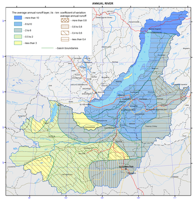
Annual river runoff
The main rivers of the Baikal basin are the Selenga, giving about a half of the river flow into the lake, with its tributaries, namely, the Chikoy, Khilok, Orkhon, and Uda, as well as the Upper Angara, Barguzin, Turka, etc.
Diversity of natural conditions of the Baikal basin causes large fluctuations in water content of rivers within the territory. The norm of the annual runoff varies from 0.62 to 27.8 L/s km2. Its value decreases from north to south, in accordance with a general decrease in precipitation and an increase in evaporation discharge. The maximum water content (from 12.7 to 27.8 L/s km2) is characteristic of the northmost rivers (the Upper Angara with its tributaries: Rel, Tyya, and Kholodnaya), as well as the rivers that originate on the slopes of the Khamar-Daban range (Bol’shaya Rechka, Snezhnaya, Khara-Murin, and Utulik). The rivers of the Ulan-Burgasy range, namely, the Turka and Kika, are characterized by high water content. The increased water content of 5.63 L/s km2 (r. Eroo) to 9.70 L/s km2 (r. Chikoy) is characteristic of the rivers of the Khentei-Chikoy highlands. The increased water content in the same range is also observed in the rivers of the Barguzin basin and in the watersheds of the Temnik and Tsakirka rivers, carrying their waters from the northern slopes of the Khamar-Daban.
The rivers of the Selenginskoe middle mountains and watercourses of the Mongolian part of the Baikal basin are characterized by the lowest water content (except for the above mentioned r. Eroo, a relatively high water content amounting to 4.65 L/s km2 is descriptive of the Tuul River with, which originates in the Khentei mountains). For all other river basins the norm of annual runoff ranges from about 1 to 3 L/s km2. The average annual runoff of the highly located watersheds of the rivers of the Khangai and Khovsgol regions is in the same range, which is due to the limited access of the moisture-bearing air masses. The greatest differences in the water content are observed in the Orkhon River basin due to combined effects of orography, terrain elevation, latitude, and soil-geological conditions.
The value of the variability of annual runoff has a general tendency of increasing from north to south and varies from 0.15 to 0.65 within the territory under consideration. Exceptions are provided by the sections of the upper reaches of the Khilok and Tuul rivers, where the values of the variation coefficient are much higher. For example, in the r. Khilok–st. Sokhondo section line (А= 1900 km2) Cv = 1.32. The annual runoff module at this point varies from 0.01 (1978) to 5.84 L/s km2 (1984). In winter, the river freezes over every year, and dries out in the summer low water years, and in some years there is no river runoff during 9 months (1965, 1967). In the r. Tuul–Ulaanbaatar section line (А = 6300 km2) Cv= 0.82, which is due to drying and through freezing of the river frequently observed here, as well as to a significant anthropogenic load. In this section line the average water consumption vary within wide limits and their values can vary up to 13 times. For example, Qav. amounted to 5.00 m3/s in 1972, 60.5 m3/s in the following 1973, 65.3 m3/s in 1993, and 7.76 m3/s in 1996; there was no winter runoff in 60% of cases of the entire observation period.
