032. Permafrost zoning map
Permafrost zoning map
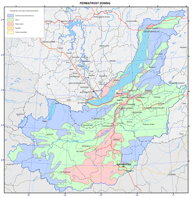
Permafrost
Permafrost occurs in abundance within the Baikal basin. According to the extent of spreading, thickness of a permafrost section and its temperature, the following five types of areas of permafrost distribution are distinguished: 1) continuous and discontinuous, 2) insular, 3) sparsely insular, 4) sporadic, and 5) without permafrost.
Continuous and discontinuous permafrost is developed on all relief features in the mid- and high-mountain and goletz areas. Unfrozen rocks occur only under large rivers, lakes and in the zones of tectonic faults with the discharge of subsurface water, along the fissures of exogenous weathering, as well as on sands, gravels and karsted rocks. The permafrost thickness reaches 100-300 m, and up to 500-600 m on watersheds. The average annual temperature ranges from -0.5 ºC to -3 ºC. Frost mounds, thermokarst, frost weathering, aufeis formation, kurum (rock stream) formation, and solifluction should be mentioned among the prevailing cryogenic processes and phenomena.
Insular permafrost. The permafrost thickness reaches 50-80 m. Islands of permafrost occur on all relief elements, but usually only in wet, waterlogged or shaded areas, and in mountains above abs. alt. of 1000-1200 m. Sand massifs and karsted rocks are usually unfrozen. The average annual temperature of permafrost ranges from -0.2 ºC to -1ºC. Thermokarst, frost mounds, aufeis formation, solifluction, and frost fracturing of soil are distinguished among the prevailing cryogenic processes and phenomena.
Sparsely insular permafrost occurs in waterlogged areas in valley bottoms, and at the bottom parts of northern slopes of hills, composed of peaty (from the surface) clay rocks. The permafrost thickness reaches 20-30 m. The average annual temperature of permafrost ranges from -0.1ºC to -0.5ºC.
Sporadic permafrost. Individual islands and lenses of permafrost occur only in wet lowlands, composed of peaty (from the surface) clay loams and sandy loams. The permafrost thickness reaches 10-15 m. The average annual temperature of permafrost varies from 0ºC to -0.2ºC. Seasonal frost mounds, relic thermokarst, and frost fracturing of soil are distinguished among the prevailing cryogenic processes and phenomena.
The area of only seasonal soil freezing has become of widespread occurrence in the Angara river valley and the Selenga river delta. Permafrost patches and neoformations are possible when developing a territory, composed of clay rocks. The depth of winter freezing of rocks ranges from 2-2.5 m in clay loams to 2.5-3 m in sands. Ground heaving, frost fracturing of soil, and relic thermokarst should be mentioned among the prevailing cryogenic processes and phenomena.
