062. Environmental potential map
Environmental potential map
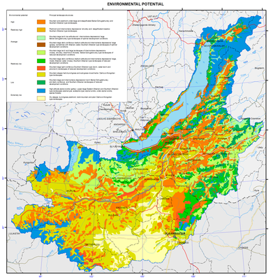
Ecological landscape potential (ELP)
The map characterises the ability of landscapes to create specific local human environment. It was compiled on the basis of ecological interpretation of landscape characteristics and consequent zoning of the Baikal basin taking into account comfort level of landscapes for human activity.
The ratio of heat and moisture supply of landscapes, as well as productivity of their plant (low, moderate, elevated, and high), was used to indicate ecological comfort of landscapes (lack of heat, excess of moisture, etc.).
Relative estimating categories (very low, low, moderate, high, and very high) are used for ELP characterisation. In the map legend, they are correlated with factors of integral functioning intensity.
