035. Soils map
Soils map
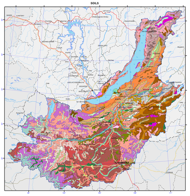
Soils
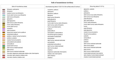
Soil associations are presented in the contours on the map. Combinations of soils, united in a contour, are associated with the altitudinal and expositional differentiation, and are determined by the character of mesorelief (combinations) and microrelief (complexes), and by the heterogeneity of the soil-forming material (mosaic). The predominant soil is the first in the legend, followed by accompanying and occurring soils. Most soils are distinguished at the type level, rarely at the subtype level.
The great extension of the territory of the Baikal basin from south to north determines latitudinal variations of the thermal factor and the associated vegetation and soil cover. In addition to these basic regular patterns, the influence of exposure and meridional arid mountain zonality is manifested here. The role of permafrost and heterogeneity of parent rocks, complicated and insufficiently clear evolution of landscapes in the past, and their changing as a result of the human impact are essential.
Within the mountain taiga, independent contours are distinguished in the south-western and north-eastern parts of Cisbaikalia. They are represented by combinations of soils with the eluvial-illuvial and undifferentiated profile. The Baikalsky Ridge and the North-Baikal Highland are dominated by podzols and podburs, involving peat-podburs and sod-podzols. They are characterized by a thin profile, which averages 30 cm in podzols of the highland, while in the mountains of Cisbaikalia it is about 40 cm. Thickness of the profile of podburs, which can be regarded as being in the early stage of soil formation, is even less.
Soils of piedmont dry steppes of Cisbaikalia are common in the Priolkhonie region and on Olkhon Island. Formation of dry steppe landscapes with chestnut soils is due to the arid mountain zonality (location in the rain shadow). The lack of atmospheric moistening is compounded here by a high water penetration capacity of woody-loamy soils. The territory is similar to that of the dry steppe of Kazakhstan in the nature of moistening, and to the middle taiga of Yakutia in heat supply. A consequence of the extreme soil-climatic conditions is a low biological productivity. Agroecosystems here are in a state of crisis; the vegetation and soil cover undergoes degradation.
In the high-mountain part of the Khamar-Daban, Muisky, Verkhne-Angarsky and Barguzinsky ridges the basic soils are petrozems, peat-lithozems, and coarse humus lithozems. Coarse humus, humic and humic-dark-humus soils are formed under the sub-alpine meadows. On the northern slopes, in relatively low relief elements, and in areas composed of parent rocks of heavier particle-size distribution, gley podburs are formed.
Cryo-lithozems, petrozems and cryo-carbo-lithozems accompany nival dissected landscapes of the Khangai region of Mongolia. Cryozems (coarse humus) and peat-cryozems are developed in the sub-goletz altitudinal belt, locating in a relatively narrow band near the forest line. In soils of taiga massifs permafrost areas are of frequent occurrence; moreover, seasonal frost is longstanding, and cryoturbation phenomena and solifluction are usual.
The structure of the soil cover of the mountain-taiga zone of Transbaikalia is heterogeneous and is largely associated with the manifestation of vertical zonality, slope exposure, and permafrost. The main soil background is comprised of podburs, podzols, sod-podzols, sod-podburs, gray-humus, humic, humic-dark-humus soils and coarse humus burozems. The main background of the soil cover of taiga territories of Mongolia includes cryozems, podburs and dark-humus soils. Soils of podzolic type are rare here. In the upper part of the taiga belt, cryozems and podburs are formed; higher there are peat-lithozems. In mountainous taiga there occur steppe "islands" with chernozem-like soils. They can be found on steep parts of the southern slopes, facing the broad areas of intermontane depressions.
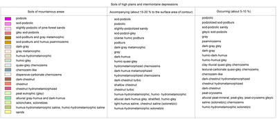
The natural-climatic zone of forest-steppe is dominated by gray metamorphic soils, which are formed on the foothill areas of depressions and on the northern slopes of hills inside intermontane lows or at the bottom part of the forested slopes of ridges, facing the steppe depressions. These soils occupy the largest areas in the forest-steppe of the southern part of the Trans-Baikal middle mountains. In the forest-steppe landscape belt of Mongolia of light-coniferous and mixed subshrub and herbaceous facies there occur dark-humus metamorphosed soils, located mainly along the southern slopes of ridges and hills. Gray humus soils formed under woody communities with forbs on carbonate rocks. This combination of soils, characteristic of different environmental conditions, is the main feature of the soil cover at the junction of taiga and steppe.
In steppe landscapes of Transbaikalia the main background of the soil cover is comprised of chernozems. They are formed under meadow and true steppes. The main massifs of these soils are located in the Tugnui-Sukhara basin: on the Tugnuisky ridge and on the southern slopes of the Zagansky ridge, on the northern slopes of the Kudarinskaya range and the Small Khamar-Daban, Monostoisky, and Borgoisky ridges. In the more northern part of the territory, chernozems are formed in individual spots on the north-western slopes of the Unegeteisky ridge and along the Uda and Itantsa river valleys.
The soil cover of dry steppe is dominated by chestnut soils. They occupy vast tracts in the Udinskaya, Priselenginskaya, and Borgoiskaya steppes, and wide gently sloping terraces in the valleys of large rivers; they are common on the southern slopes of the ridges. On the watersheds of high ridges there occur soils of the lithozem group. Humus psammozems are formed on aeolian sand deposits of the dry steppe zone, especially in the Selenga-Chikoy and Chikoy-Khilok interfluves, and on pine-forest sands.
Soils of the river valleys of Cisbaikalia and Transbaikalia are represented mainly by alluvial humic-gley, peat-gley, dark-humus, gray-humus, and dark-humus quasi-gley soils. In the structure of the soil cover of the floodplains of the upper and middle reaches of the rivers stratified alluvial soils are of frequent occurrence. In the steppe and especially in the dry steppe zones of Transbaikalia solonchaks and less frequently solonetzic soils are formed in the river floodplains. They occupy mostly lacustrine depressions and lower parts of gentle slopes, generally adjacent to the river floodplains, where there is a zone of accumulation of waters of the valley runoff enriched with soluble salts or a discharge of mineralized groundwaters. The most common types of salinization of solonchaks and solonetzic soils are sulfate-soda, soda-sulfate, sulfate, and chloride-sulphate. Large massifs of saline soils are widespread in the Borgoiskaya steppe and lacustrine lows of Lakes Verkhnee Beloe and Nizhnee Beloe. Their proportion in the Ivolginskaya depression is quite substantial. Solonetzic soils and solonchaks also occur in lacustrine depressions of the Bichursky district and the Tugnuiskaya steppe. In the Selenga river delta, in the Barguzin river valley, and in some other regions relatively large massifs are covered with bogs, where mainly peat eutrophic and peat eutrophic gley soils develop.
Soils of waterlogged meadows and lacustrine-boggy complexes of Mongolia are widespread in the near-shore zone of Lakes Khovsgol and Doot-Nur, in the Dzhargalant-Gol and Mungaral-Gol interfluve, in the northern and southern part of the Darkhatskaya depression, and along river valleys. Alluvial dark-humus soils are formed in river floodplains on elevated areas, in deltas, and on alluvial fans of temporary streams. Alluvial humic gley soils are formed under the conditions of additional inflow of moisture. In elevated locations of the riverbed floodplain of mountain rivers on sandy-gravel deposits gray-humus alluvial and stratified soils were formed. Alluvial peat-gley (peat-mineral) soils are formed in relatively low locations of river floodplains with the conditions of long-term surface and subsurface moistening, as well as on the edges of water bodies overgrown with bog vegetation. Humus-hydrometamorphic seasonally freezing for a long time soils are formed in the central floodplain of the rivers. In the lacustrine part of the depressions humic-hydrometamorphic (silty-humic) cryogenic soils are developed.
In the territory of Mongolia a series of relatively small contours of saline soils occurring in different parts of the country was distinguished. Processes of erosion and deflation are widespread, which is due to the shower precipitation pattern, and periodic occurrence of dust storms and strong winds, especially in spring when soil is dry and vegetation grows poorly.
