060. Environmental landscapes map
Environmental landscapes map
Environment resources: ecological resources of landscapes in the Baikal basin
This package contains small-scale overview maps with the most common patterns of ecological resources of landscapes in the Baikal basin. The definition “ecological resource”, which is identical to the definition “ecological potential”, means the ability of landscapes to provide people with all necessary conditions for existence, i.e. to create specific local environment.
The structure of the map package was developed as applicable to the solution of practical problems of information support of regional programmes on rational use and protection of natural landscapes. The information base of the package consists of literature sources [Geosystems …, 1991; Isachenko, 1990; Mikheev, 1987, 1988; Polikarpov et al., 1980; Sochava, 2005], cartographic material [Atlas …, 2004; National Atlas …, 1990; Correlation …, 1977; Landscapes …, 1977; Eco-geographic …, 1996] and Internet resources.
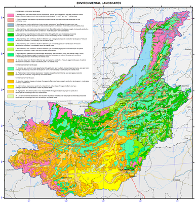
Landscape-ecological complexes
This map is a mosaic of 16 structural landscape subdivisions belonging to 2 subcontinents (Northern and Central Asia) and 3 types of natural conditions (arctic-boreal, semiarid and arid) [Geosystems …, 1991].
Typological classification of landscapes (goletz, subgoletz, upper taiga, taiga, subtaiga and steppe) reflects altitude-zonal differentiation of environmental conditions, as well as depression and piedmont effects of their manifestation. Regional range of landscapes classification (Baikal-Dzhugdzhurskiye, South-Siberian, Central Asian, Khangaisko-Daurskiye, Srednekhalkhasko-Mongolian) includes sector differentiation of environmental conditions formed under the influence of prevailing air masses of different direction (mainly western and eastern transfer), as well as interpenetration and uniqueness of natural phenomena in the basin of Lake Baikal.
According to the material and energy exchange, the North-Asian goletz, taiga and subtaiga landscapes are subdivided into subgroups of natural conditions: extreme, reduced, limited and optimal development. South-Siberian and Central Asian steppe landscapes are subdivided into arid, dry and very dry landscapes depending on moisture supply of these landscapes.
The legend of the map also presents numerical values of integral intensity of landscape functioning (heat and moisture supply of landscapes and plant biological productivity) [Eco-geographic …, 1996]:
- heat supply (total mean daily temperatures over 10ºC): cold (600-800ºC), moderately cold (800-1200 ºC), moderately warm (1200-1600 ºC) and warm (1600-2000 ºC);
- moisture supply (radiation dryness index according to M. Budyko): perhumid (less than 0.5), humid (0.5-0.9), subhumid (1.0-1.4), insufficiently humid (1.5-1.9), dry (2.0-2.4), and very dry (over 2.5);
- plant biological productivity (annual growth of plants at appropriate values of heat and moisture expressed in dry mass of organic matter of terrestrial and underground parts of plants): very low (less than 20 metric centners/ha), low (20-40 metric centners/ha), mean (40-60 metric centners/ha), elevated (60-80 metric centners/ha), and high (over 80 metric centners/ha).
This map is used as an interpretation basis for the development of derived assessment and recommendation maps of the environment.
