051. Land resources use map
Land resources use map
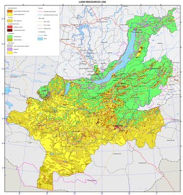
Land resources and their use
Land resources are the main spatial basis, a store of various types of mineral resources for many branches of industry, as well as a basic means of production for agriculture and forestry. For the latter branches land resources and soil fertility are important means of growing crops and forest stands. For other types of land use (residential, transport, etc.) the role of land resources is reduced mainly to the role of the operational basis for spatial location of specific objects inherent to these types of land use.
Under the working legislation and established practice state land registration in the Russian Federation is carried out on land categories and agricultural lands, forms of ownership and types of land rights, as well as their use for agricultural production and other needs. Land registration in Mongolia is carried out similarly (with minor changes).
On the basic map the land fund structure on agricultural lands is presented as a quality background. The latter ones are defined as land, systematically used or usable for specific economic purposes and different in their natural and historical features. Land carries material properties typical of land use as an economic phenomenon.
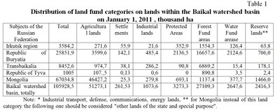
The second map and the Table represent the layout of the land fund on land categories and the index of availability of agricultural land. Land categories are land plots distinguished according to their intended use (agricultural land, settlements, industry, energy, transport, communication, defense and security, etc., forest, water resources, reserves, etc.). Mongolia is characterized by the absence of the concept of "land reserve". However, a large share of the land fund structure there belongs to public land for special purposes, which consists not only of lands of defense and security and protected areas, but lands, used in ways uncharacteristic of Russia. Therefore, in the map legend the category "lands of state and special purpose" applies only to Mongolia, excluding the land of specially protected natural areas and defense and security lands. The latter ones are included in the respective land categories.
The availability index of farmland is the ratio of agricultural land area (in hectares) belonging to the agricultural land to the number of residents living in the municipality. Farmland is an essential part of land, which is a potential resource for the formation of local food base. The average area of agricultural land per capita (within Russian territory, except Tere-Khol district of the Republic of Tyva) amounts to 3.7 hectares; it ranges from 0.06 ha within Sludyansky district of Irkutsk oblast to 22.9 ha in the Eravninsky district of the Republic of Buryatia. Within the Mongolian territory the indicators of the agricultural land per aimak inhabitant, is on the average significantly higher than in the Russian part of the basin as it amounts to about 45 hectares. Minimum rates are found in the Ulaanbaatar, Darkhan, and Orkhon aimaks, which is connected, first of all, with the high population numbers in these aimaks and relatively smaller areas of agricultural land compared to other aimaks.
In 1990 – 2010 the reduction of agricultural area for most municipalities is registered in the Russian part of the basin, which is directly linked to their withdrawal from agricultural use. The main reason of the reduction of such agricultural areas was shutdown of many agricultural enterprises, organizations, and farms and transfer of the withdrawn lands, for the most part, to the land redistribution fund. Another reason is the expiration of the land leasehold (or temporary use) and non renewal of its agricultural productivity. The agricultural land reduction is caused by negative processes became widespread due to the sharp reduction of valuable land protection measures from water and wind erosion, flooding, bogging, waterlogging and other processes. It should be noted that the actual outflow of productive land is much higher. Previously transferred farmland reserves are overgrown with shrubs and low forests and lose their agricultural value.
In Mongolia problems of agricultural lands reduction are currently not registered because of their significant amount due to natural factors and historical specific features of agriculture.
