Atlas
Non-profit environmental organizations map
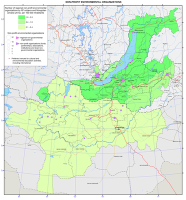
Environmental non-profit organizations
The environmental well-being of the Baikal basin is largely determined by the activities of environmental non-governmental organizations (eco-NGOs). The main purpose of eco-NGOs is to protect nature. They see the foundation for sustainable development of society in nature preservation. Their effectiveness is determined by personal qualities and civic engagement of their activists and, especially, their leaders.
The number of eco-NGOs significantly increased in the 1990s, which was determined by state reforms in Russia and Mongolia and the growing interests of citizens towards the state of the environment.
Eco-NGOs operating in the Baikal basin differ by their territorial status (international, national, inter-regional, regional and local) and organizational and legal forms (community associations: community-based organizations, community-based foundations, community-based institutions, and community movements; nonprofit organizations: autonomous nonprofits, nonprofit foundations, nonprofit partnerships, associations (unions, alliances) of legal persons, and nonprofit institutions).
In Mongolia, the creation of eco-NGOs is mainly associated with the efforts to protect the Selenga and its tributaries from negative impacts of mining, construction of hydro-power plants, and the transfer of the Orkhon water to arid areas of the Gobi desert. Eco-NGOs are also created in all river basins, where open-pit mining operations are active. The largest community associations are the “United Movement of Rivers and Lakes of Mongolia” and “Nature Protection Coalition of Mongolia”. Eco-NGO campaigns usually involve 300-8,000 people.
In the Russian part of the Baikal basin, the organizations defining community-based environmental activities aimed to protect Lake Baikal are the community-based organization “All-Russian Nature Conservation Society” and the public organization “Russian Geographical Society”. Branches of these organizations are located in all the regions of the Baikal basin. In 2012, among the participants of the project initiated by the All-Russian Nature Conservation Society and entitled "Clean Waters of the Baikal Region" were over 60 environmental organizations created at educational institutions of 23 districts of Irkutsk oblast. Members of the Russian Geographical Society include both private individuals and legal persons. A widely known member of the Russian Geographical Society is the “Fund for Protection of Lake Baikal” established by Metropol Group of Companies. A lot of work is done by the nonprofit organization "WWF - Russia" and other all-Russian organization.
As of the beginning of 2013, the total number of registered eco-NGOs in Buryatia, Zabaikalsky krai and Irkutsk oblast was about 100 organizations. The overwhelming majority of them are community associations and community-based organizations.
In Buryatia, the most famous eco-NGOs include regional community associations "The Buryat Regional Association on Baikal", "Baikal Information Center Gran", "Baikal-Eco", "Ecological Association LAT", "Ecological and Humanitarian Center ETNA", "Ecological center The Planet and Delta", "Ecoleague", nonprofit partnership "The Great Baikal Trail - Buryatia", and a local environmental NGO "Turka". In Irkutsk oblast, they include regional nonprofit organizations "Baikal Environmental Wave" (BEW), "The Baikal Ecological Network Association", "Baikal Environmental Patrol", Inter-regional community-based organization "The Great Baikal Trail", private non-state research institution "The Baikal Center of Field Studies “Wildlife of Asia”, nonprofit partnership "Protecting Baikal Together", and the Irkutsk city community organization "Children’s Ecological Union". In Zabaikalsky krai, there is a regional public institution “Public Environmental Center “Dauria”. There are also many other successful organizations.
Regional and local eco-NGOs actively attract volunteers from different countries to implement their projects, so quite often these projects become international.
Information about the work of the most active eco-NGOs operating in the Russian part of the Baikal basin is provided in public reports on the state of Lake Baikal and governmental reports on the state and protection of the environment in Buryatia, Zabaikalsky krai and Irkutsk oblast. Brief descriptions about them in the form of short essays are also presented in the reference book entitled “The White Book”, prepared by the eco-NGO “Ecoleague” and published in 2010.
Among the organizations whose head-quarters are located outside of Russia and Mongolia, the Russian branch of the international non-governmental non-profit organization Greenpeace conducts a very active work on Lake Baikal.
In the Baikal basin, eco-NGOs conduct research, educational, and outreach activities among the population, boost its environmental activity, and involve local communities in the decision-making process. They organize community oversight and participate in the preparation and discussion of laws aimed at optimizing natural resources management. They take part in public hearings on the development of deposits and construction of industrial facilities and participate in the creation of protected areas. They also develop eco-tourism, conduct cleaning works on the lake’s shores and other activities, including the "Days of Baikal". Often, eco-NGOs receive federal or regional funding by winning competitions of socially-oriented projects.
Eco-NGOs help unite the efforts of government, science, business, and society in finding solutions of environmental problems. They become members of public environmental councils in the regions and conduct conferences, round tables, telethons, presentations, seminars, courses, summer schools, etc. In 2013, BEW conducted an international conference in Irkutsk and Listvyanka ("Rivers of Siberia and the Far East",). Also in 2013, the Russian Society for Ecological Economics jointly with the Irkutsk branches of the Russian Geographical Society and All-Russian Nature Conservation Society conducted a conference in Irkutsk entitled “The management of ecological and economic systems: Interaction of government, business, science, and society”.
The creation of eco-NGOs’ coalitions and international cooperation is extremely important for reaching the goals of sustainable development of the regions. It determined the creation of a network of eco-NGOs in Buryatia and Mongolia called "Friends of Baikal" and a long-term cooperation with the US organization "Tahoe-Baikal Institute" to share best practices in natural resources management in the watershed basins of Lake Baikal, Tahoe, Khovsgol, and the Great Lakes. Other joint projects promoting sustainable development of communities of different levels are also being implemented.
It is mostly due to the work of eco-NGOs that Lake Baikal was inscribed on the list of World Heritage Sites, the Baikal Natural Territory was zoned, over 700 kilometers of trails were built, and the operation of several environmentally hazardous production facilities, including the Baikalsk Pulp and Paper Mill, was stopped. On the site of this Pulp and Paper Mill, in December 2013, Russian government decided to create a nature protection complex, which will include a museum and exhibition, as well as information and educational facilities. In order to manage this complex, the government jointly with the Charitable Foundation for Environmental Protection "Green Future" (NF, Moscow) created ANO “Expocenter “Reserves of Russia””. Often, the results of the work of eco-NGOs become the foundation of major federal and regional programs.
Document Actions
Pasture degradation map
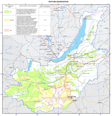
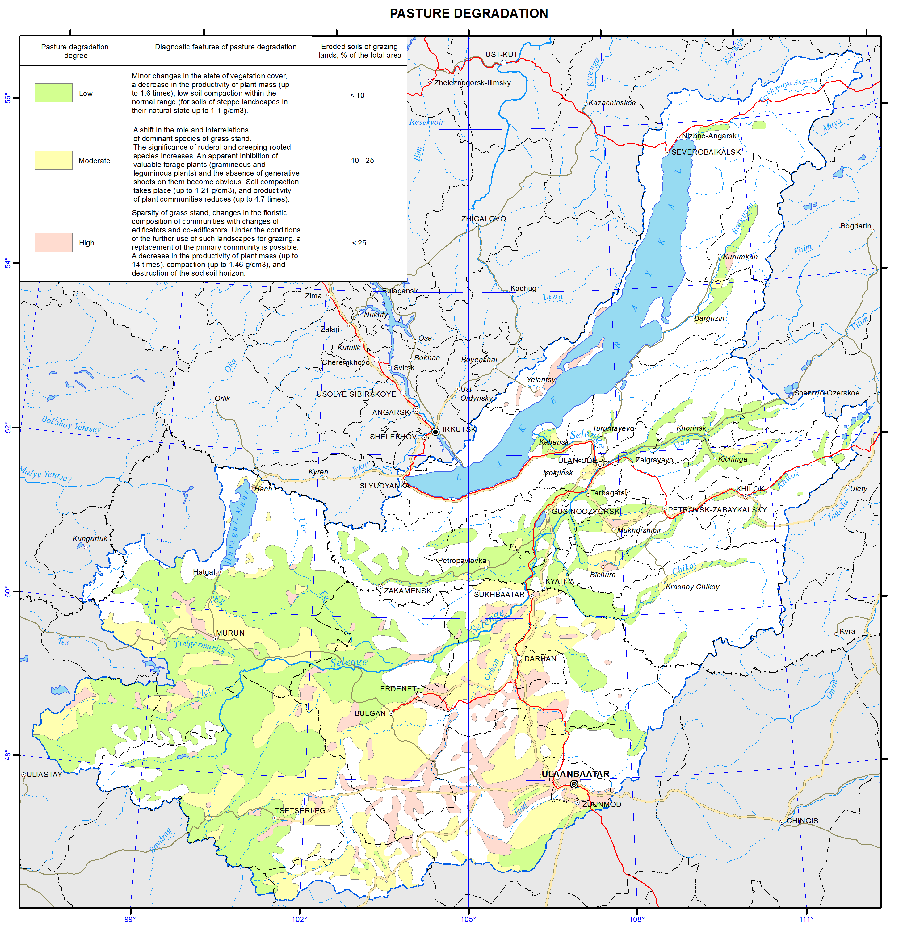
Pasture Degradation
Under the conditions of a complex geomorphological structure of the territory, uneven particle-size distribution, and often thin profile of soils, degradation processes are dominated by linear and sheet erosion. Based on the intensity of development of water erosion and deflation processes and, consequently, different disturbances of the soil profile, as well as according to the results of evaluating the areal development of all types of erosion processes, three degrees of land degradation are shown on the map in shading: slight, moderate, and severe. They were determined by the share of the main categories of eroded soils as a percentage of the agricultural lands area. Twenty-four percent, up to 42%, 47%, and more than 60% of developed lands are eroded in varying degrees in the Baikal region, in the territory of the Republic of Buryatia, in the Olkhon district, and in some areas of Mongolia, respectively.
As a result of a special analysis and assessment of the pasture condition, three categories of the degree of their degradation are distinguished in the map “Pasture degradation”, namely: low, moderate, and high. The map’s explanatory note explains the diagnostic features of pasture degradation. The predominant part of pastures experiencing moderate anthropogenic impact is classified as slightly or moderately disturbed.
In general, the map is the basis for preventing the development of dangerous geo-ecological situations in the region, organizing environmental activities, and optimizing the management of the biogeochemical environment of the population’s life-sustaining activities.
References
Dorzhgotov, D. and Batkhishig, O. (2009). Soils: The soil and geographical zoning of Mongolia. National Atlas of Mongolia. Ulaanbaatar. p 120-122.
Dorzhgotov, D. (1976). Soil classification of Mongolia. Ulaanbaatar. p 170.
Dorzhgotov, D. (2003). Soils of Mongolia. Ulaanbaatar. p 370.
Kuzmin, V. A. (2004). The soil cover: The soil and ecological zoning of Irkutsk oblast. Atlas of Irkutsk oblast. Irkutsk. p 40-41.
Nechaeva, E. G., Belozertseva, I. A., Naprasnikova, E. V., Vorobyeva, I. B., Dubynina, S. S., Davydova, N. D., & Vlasova N. V. (2010). Monitoring and forecasting of the substance-dynamical state of geosystems in Siberian regions. Novosibirsk: Nauka. p 315.
Nechaeva, E. G. (2001). Landscape-geochemical zoning of Asian Russia. Geography and Natural Resources, 1. p 12-18.
Nechaeva, E. G., Belozertseva, I. A., Davydova, N. D., & Sorokovoy, A. A. (2009). The map of degradation and contamination of the soil cover. Scale 1:5,000,000. Electronic atlas of natural resources, economy, and population of the Baikal Region. Irkutsk: V.B. Sochava Institute of Geography SB RAS.
Sochava, V. B., Timofeev, D. A. (1968). Physical and geographical regions of North Asia. Proceedings of the Institute of Geography of Siberia and the Far East, 19. p 3-19.
Ubugunov, L. L., Badmaev, N. B., Ubugunova, V. I., Gyninova, A. B., Balsanova, L. D., Ubugunov, V. L., Gonchikov, B. N., & Tsybikdorzhiev, T. D-T. (2011). Soil map of Buryatia. Scale 1:3,000,000. Ulan-Ude: Institute of General and Experimental Biology SB RAS.
Khismatullin, S. D. (1991). Erosion on agricultural lands of Irkutsk oblast. Geography and Natural Resources, 4. p 49-61.
Shishov, L. L., Tonkonogov, V. D., Lebedeva, I. I., & Gerasimova, M. I. (2004). Classification and diagnostics of soils of Russia. Smolensk: Oikumena. p 342.
Degradation of ecosystems. (2005). In E. A. Vostokova & P. D. Gunin (Eds.), Atlas of Ecosystems of Mongolia. Moscow. p 44.
Document Actions
Permafrost zoning map
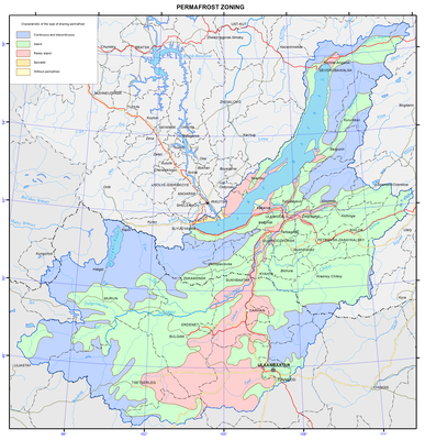
Permafrost
Permafrost occurs in abundance within the Baikal basin. According to the extent of spreading, thickness of a permafrost section and its temperature, the following five types of areas of permafrost distribution are distinguished: 1) continuous and discontinuous, 2) insular, 3) sparsely insular, 4) sporadic, and 5) without permafrost.
Continuous and discontinuous permafrost is developed on all relief features in the mid- and high-mountain and goletz areas. Unfrozen rocks occur only under large rivers, lakes and in the zones of tectonic faults with the discharge of subsurface water, along the fissures of exogenous weathering, as well as on sands, gravels and karsted rocks. The permafrost thickness reaches 100-300 m, and up to 500-600 m on watersheds. The average annual temperature ranges from -0.5 ºC to -3 ºC. Frost mounds, thermokarst, frost weathering, aufeis formation, kurum (rock stream) formation, and solifluction should be mentioned among the prevailing cryogenic processes and phenomena.
Insular permafrost. The permafrost thickness reaches 50-80 m. Islands of permafrost occur on all relief elements, but usually only in wet, waterlogged or shaded areas, and in mountains above abs. alt. of 1000-1200 m. Sand massifs and karsted rocks are usually unfrozen. The average annual temperature of permafrost ranges from -0.2 ºC to -1ºC. Thermokarst, frost mounds, aufeis formation, solifluction, and frost fracturing of soil are distinguished among the prevailing cryogenic processes and phenomena.
Sparsely insular permafrost occurs in waterlogged areas in valley bottoms, and at the bottom parts of northern slopes of hills, composed of peaty (from the surface) clay rocks. The permafrost thickness reaches 20-30 m. The average annual temperature of permafrost ranges from -0.1ºC to -0.5ºC.
Sporadic permafrost. Individual islands and lenses of permafrost occur only in wet lowlands, composed of peaty (from the surface) clay loams and sandy loams. The permafrost thickness reaches 10-15 m. The average annual temperature of permafrost varies from 0ºC to -0.2ºC. Seasonal frost mounds, relic thermokarst, and frost fracturing of soil are distinguished among the prevailing cryogenic processes and phenomena.
The area of only seasonal soil freezing has become of widespread occurrence in the Angara river valley and the Selenga river delta. Permafrost patches and neoformations are possible when developing a territory, composed of clay rocks. The depth of winter freezing of rocks ranges from 2-2.5 m in clay loams to 2.5-3 m in sands. Ground heaving, frost fracturing of soil, and relic thermokarst should be mentioned among the prevailing cryogenic processes and phenomena.
