Soil degradation and contamination map
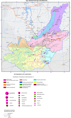
Soil degradation and contamination
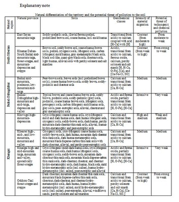
The background basis of this map is the differentiation of the soil cover according to the conditions of its self-purification capacity, controlled by the processes of migration and accumulation of chemical elements. In this regard, the largest territory units are landscape-geochemical areas. They are distinguished based on the boundaries of the major lithological-geomorphological structures and bioclimatic conditions.
More fractional territory subdivisions are landscape-geochemical provinces, singled out based on a complex of factors of potential contamination of soils and their degradation in the process of different types of nature management. Among these factors is the zonal and altitude-belt specificity of bioclimatic conditions, determined by hydrothermal parameters of the territory. The possibility of involving elements-pollutants of the environment in the biological cycle and the food chain of living organisms depends on them. The rate of development of biochemical processes of pollutants transformation in the soil medium and neutralization of their toxic action also depends on the amount and ratio of heat and moisture. Another equally important factor of self-purification of the soil cover is the water migration of material. Criteria for determining the differentiation of the territory according to the intensity of material migration (IMM) are topography and true altitude (TA) of the area. Weak IMM is peculiar to lowland plain surfaces with TA below 200 m; medium IMM – to low-mountain relief terrain, and high and low plateau with TA from 400 to 600 m; high IMM – to middle altitudes and steep slopes with TA of 600-1000 m; and intensive IMM – to high mountains with TA above 1000 m. Mountain-depression landscapes widespread within the given territory are characterized by contrast migration: from intense to weak.
Geochemical classes, denoted by the indices of typomorphic elements, contain the integral characteristics of the soil medium, which is depositing with respect to the pollutants. The classes reflect alkaline-acid and redox conditions of the environment peculiar to different landscapes: the main factors of functioning of the migration-accumulation mechanism in soils and formation of various geochemical barriers, where elements-pollutants may deposit.
Based on these main criteria for evaluating the self-purification capacity of soils taking into account the location of currently functioning sources of industrial emissions into the environment within the territory, an assessment of the hazard level of its technogenic-chemical pollution was made.
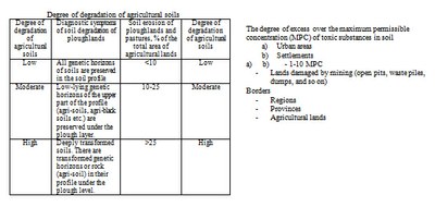
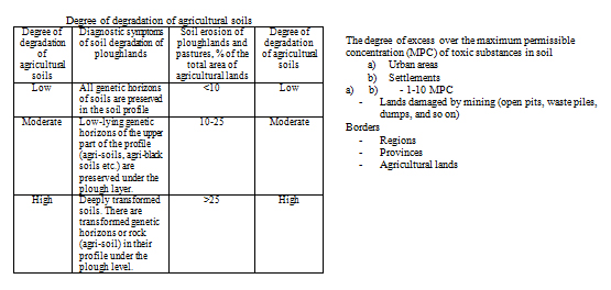
Against the background of the degree of the potential hazard of soil contamination estimated according to the natural factors, the main sources of pollution are shown. They are industrial and boiler facilities of the towns of Slyudyanka, Baikalsk, Severobaikalsk, Nizhneangarsk, Listvyanka, Ulan-Ude, Gusinoozersk, Petrovsk-Zabaikalsk, Kyakhta, Ulaanbaatar, Darkhan, Erdenet, Zuunmod, etc. Virtually all industrial complexes are located in the conditions with insufficient self-purification of the environment, and those ones, emissions of which are heading toward the Baikal depression, represent a factor of environmental risk for it. The map shows the areas of soil contamination with the exceedance of pollutants MPC, their total emissions, industrial sources, and their contribution to air pollution. The pollution halos, 1-10 times exceeding the MPC values in the sum of the priority toxic elements (hazard class I-III), are contoured with a linear map sign. Emission rates into the atmosphere are presented in a pie chart for the sources with emissions of more than one thousand tons per year. The proportion (%) of different industries in the gross emissions is marked in the diagram. Halos with the emission sources of less than one thousand tons per year cover a small area, and in the given scale they are marked with point signs.
A significant contribution to the mechanical degradation and contamination of the soil cover in the Baikal basin, rich with various mineral resources, is made by their industrial development. Conventional signs mark the lands of mining industry (quarries, terricones, dumps, etc.). The most significant in size and intensive in the degree of disturbance of the soil cover and the geological environment are objects, registered in the Gusinoozersky and Erdenetsogt coal basins.
